ATL: IAN - Models
Moderator: S2k Moderators
-
Iceresistance

- Category 5

- Posts: 9592
- Age: 22
- Joined: Sat Oct 10, 2020 9:45 am
- Location: Tecumseh, OK/Norman, OK
Re: ATL: INVEST 98L - Models
First HWRF weakens this back to a TD because of the Northerly Wind Shear by Fiona.
0 likes
Bill 2015 & Beta 2020
Winter 2020-2021
All observations are in Tecumseh, OK unless otherwise noted.
Winter posts are focused mainly for Oklahoma & Texas.
Take any of my forecasts with a grain of salt, refer to the NWS, SPC, and NHC for official information
Never say Never with weather! Because ANYTHING is possible!
Winter 2020-2021
All observations are in Tecumseh, OK unless otherwise noted.
Winter posts are focused mainly for Oklahoma & Texas.
Take any of my forecasts with a grain of salt, refer to the NWS, SPC, and NHC for official information
Never say Never with weather! Because ANYTHING is possible!
Re: ATL: INVEST 98L - Models
Iceresistance wrote:First HWRF weakens this back to a TD because of the Northerly Wind Shear by Fiona.
I was wondering about Fionas influence on 98L...
0 likes

Re: ATL: INVEST 98L - Models
Iceresistance wrote:First HWRF weakens this back to a TD because of the Northerly Wind Shear by Fiona.
Pretty much the same as the GFS. This shear ablates in the day 4-5 range as an upper-level anticyclone begins to establish itself over 98L/Hermine. The end of the HWRF run should, in theory, show reorganization and intensification.
0 likes
Irene '11 Sandy '12 Hermine '16 5/15/2018 Derecho Fay '20 Isaias '20 Elsa '21 Henri '21 Ida '21
I am only a meteorology enthusiast who knows a decent amount about tropical cyclones. Look to the professional mets, the NHC, or your local weather office for the best information.
I am only a meteorology enthusiast who knows a decent amount about tropical cyclones. Look to the professional mets, the NHC, or your local weather office for the best information.
-
chris_fit

- Category 5
- Posts: 3261
- Age: 43
- Joined: Wed Sep 10, 2003 11:58 pm
- Location: Tampa Bay Area, FL
Re: ATL: INVEST 98L - Models
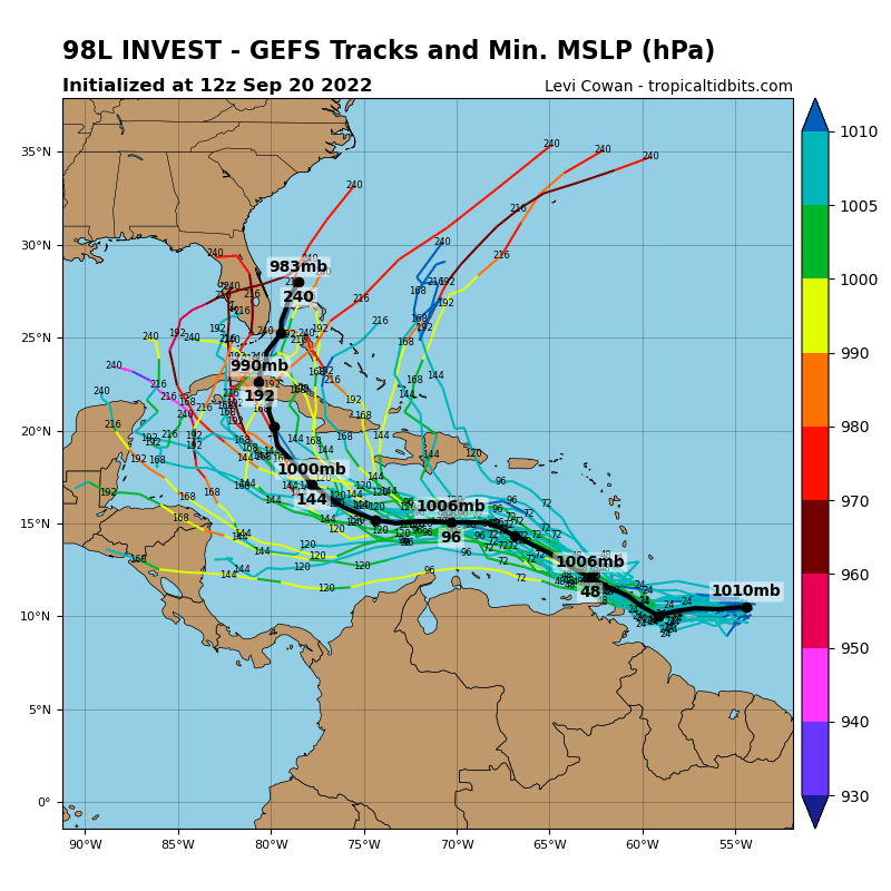
12z GEFS, while W of the 06z Suite, most (almost all) are also E of the 12z OPS

0 likes
-
SFLcane

- S2K Supporter

- Posts: 10281
- Age: 48
- Joined: Sat Jun 05, 2010 1:44 pm
- Location: Lake Worth Florida
Re: ATL: INVEST 98L - Models
chris_fit wrote:12z GEFS, while W of the 06z Suite, most (almost all) are also E of the 12z OPS
https://i.imgur.com/QvfWHEq.gif
Indeed this has been the story for runs now.
0 likes
-
TallyTracker
- Category 2

- Posts: 787
- Joined: Thu Oct 11, 2018 2:46 pm
Re: ATL: INVEST 98L - Models
HurricaneBelle wrote:This run would be disastrous for Tallahassee
Agreed! While the last Hermine thinned out some trees, our grid would be wrecked for many weeks with a run like that. Not to mention the clay soils would cause massive flash flooding. A couple of summer downpours over washed some roads as-is.
1 likes
Fran '96, Georges '98, Gordon '00, Gabrielle '01, Charley '04, Frances '04, Jeanne '04, Barry '07, Fay '08, Debby '12, Matthew '16, Emily '17, Irma '17, Michael ‘18, Elsa ‘21, Fred ‘21, Mindy ‘21, Nicole ‘22, Idalia ‘23, Debby ‘24, Helene ‘24
-
toad strangler

- S2K Supporter
- Posts: 4546
- Joined: Sun Jul 28, 2013 3:09 pm
- Location: Earth
- Contact:
Re: ATL: INVEST 98L - Models
chris_fit wrote:12z GEFS, while W of the 06z Suite, most (almost all) are also E of the 12z OPS
https://i.imgur.com/QvfWHEq.gif
Almost all of those members take a turn to the N and then NE regardless of where they are. So, there ain't no "trends" past the central and western half of the Caribbean right now. Too far out
3 likes
My Weather Station
https://www.wunderground.com/dashboard/pws/KFLPORTS603
https://www.wunderground.com/dashboard/pws/KFLPORTS603
-
CrazyC83
- Professional-Met

- Posts: 34315
- Joined: Tue Mar 07, 2006 11:57 pm
- Location: Deep South, for the first time!
Re: ATL: INVEST 98L - Models
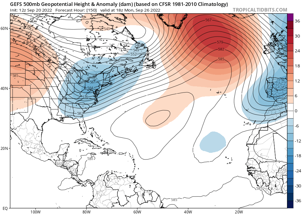
The keys I think are the speed of 98L/Hermine and the trough incoming. There's strong support for a powerful trough coming down around the end of September.
4 likes
-
Iceresistance
- Category 5
- Posts: 9592
- Age: 22
- Joined: Sat Oct 10, 2020 9:45 am
- Location: Tecumseh, OK/Norman, OK
Re: ATL: INVEST 98L - Models
0 likes
Bill 2015 & Beta 2020
Winter 2020-2021
All observations are in Tecumseh, OK unless otherwise noted.
Winter posts are focused mainly for Oklahoma & Texas.
Take any of my forecasts with a grain of salt, refer to the NWS, SPC, and NHC for official information
Never say Never with weather! Because ANYTHING is possible!
Winter 2020-2021
All observations are in Tecumseh, OK unless otherwise noted.
Winter posts are focused mainly for Oklahoma & Texas.
Take any of my forecasts with a grain of salt, refer to the NWS, SPC, and NHC for official information
Never say Never with weather! Because ANYTHING is possible!
-
AutoPenalti
- Category 5
- Posts: 4091
- Age: 29
- Joined: Mon Aug 17, 2015 4:16 pm
- Location: Ft. Lauderdale, Florida
Re: ATL: INVEST 98L - Models
That's weird, the ensembles members are a bit west before SFL...
1 likes
The posts in this forum are NOT official forecasts and should not be used as such. They are just the opinion of the poster and may or may not be backed by sound meteorological data. They are NOT endorsed by any professional institution or STORM2K. For official information, please refer to products from the NHC and NWS.
Model Runs Cheat Sheet:
GFS (5:30 AM/PM, 11:30 AM/PM)
HWRF, GFDL, UKMET, NAVGEM (6:30-8:00 AM/PM, 12:30-2:00 AM/PM)
ECMWF (1:45 AM/PM)
TCVN is a weighted averaged

-
CrazyC83
- Professional-Met
- Posts: 34315
- Joined: Tue Mar 07, 2006 11:57 pm
- Location: Deep South, for the first time!
Re: ATL: INVEST 98L - Models
AutoPenalti wrote:
That's weird, the ensembles members are a bit west before SFL...
That would be because of a strong trough most likely.
3 likes
-
MississippiWx

- S2K Supporter
- Posts: 1720
- Joined: Sat Aug 14, 2010 1:44 pm
- Location: Hattiesburg, Mississippi
Re: ATL: INVEST 98L - Models
Looks like the farthest east members went even more to the east. Looks like more spread than before. We have a long way to go with this one.
1 likes
This post is not an official forecast and should not be used as such. It is just the opinion of MississippiWx and may or may not be backed by sound meteorological data. It is not endorsed by any professional institution including storm2k.org. For Official Information please refer to the NHC and NWS products.
-
SFLcane
- S2K Supporter
- Posts: 10281
- Age: 48
- Joined: Sat Jun 05, 2010 1:44 pm
- Location: Lake Worth Florida
Re: ATL: INVEST 98L - Models
AutoPenalti wrote:
That's weird, the ensembles members are a bit west before SFL...
OP models are very unrealiable past 5 days its best to go with ensembles gives you a better look at what might happen. In my opinion atleast. Even some of the weak ones find there way into SFL.
Last edited by SFLcane on Tue Sep 20, 2022 1:11 pm, edited 2 times in total.
1 likes
Re: ATL: INVEST 98L - Models
HWRF/HMON are closer to the CMC than the GFS: weaker, longer to start intensifying in the WCar, and headed for Central America instead of Cuba and Florida.
3 likes
Irene '11 Sandy '12 Hermine '16 5/15/2018 Derecho Fay '20 Isaias '20 Elsa '21 Henri '21 Ida '21
I am only a meteorology enthusiast who knows a decent amount about tropical cyclones. Look to the professional mets, the NHC, or your local weather office for the best information.
I am only a meteorology enthusiast who knows a decent amount about tropical cyclones. Look to the professional mets, the NHC, or your local weather office for the best information.
-
toad strangler
- S2K Supporter
- Posts: 4546
- Joined: Sun Jul 28, 2013 3:09 pm
- Location: Earth
- Contact:
Re: ATL: INVEST 98L - Models
aspen wrote:HWRF/HMON are closer to the CMC than the GFS: weaker, longer to start intensifying in the WCar, and headed for Central America instead of Cuba and Florida.
Aren't the hurricane models used primarily after real genesis??
Last edited by toad strangler on Tue Sep 20, 2022 1:16 pm, edited 1 time in total.
0 likes
My Weather Station
https://www.wunderground.com/dashboard/pws/KFLPORTS603
https://www.wunderground.com/dashboard/pws/KFLPORTS603
Re: ATL: INVEST 98L - Models
Please forgive me if I'm wrong, would this run be in response to a front entering Florida by the weekend?...pulling whatever 98L is North and Eastward? NWS Tallahassee forecast discussion mentions a front sagging southward Friday into the region.
Last edited by underthwx on Tue Sep 20, 2022 1:20 pm, edited 1 time in total.
0 likes
-
MississippiWx
- S2K Supporter
- Posts: 1720
- Joined: Sat Aug 14, 2010 1:44 pm
- Location: Hattiesburg, Mississippi
Re: ATL: INVEST 98L - Models
aspen wrote:HWRF/HMON are closer to the CMC than the GFS: weaker, longer to start intensifying in the WCar, and headed for Central America instead of Cuba and Florida.
When the GFS is the only model to show quick development, that sends up a red flag. When you factor in the trend on the GFS has been weaker and further south in the short term, that sends up another red flag. I think the shear from Fiona is going to impede any quick development for a few days, but that changes in the Western Caribbean.
0 likes
This post is not an official forecast and should not be used as such. It is just the opinion of MississippiWx and may or may not be backed by sound meteorological data. It is not endorsed by any professional institution including storm2k.org. For Official Information please refer to the NHC and NWS products.
-
SFLcane
- S2K Supporter
- Posts: 10281
- Age: 48
- Joined: Sat Jun 05, 2010 1:44 pm
- Location: Lake Worth Florida
Re: ATL: INVEST 98L - Models
underthwx wrote:
Please forgive me if I'm wrong, would this run be in response to a front entering Florida by the weekend?...pulling whatever 98L is North and Eastward?
Yup. Timing is eveything!
0 likes
Who is online
Users browsing this forum: No registered users and 27 guests