ATL: IAN - Models

Moderator: S2k Moderators

Message
Author
User avatar
gatorcane
S2K Supporter
S2K Supporter
Posts: 23691
Age: 47
Joined: Sun Mar 13, 2005 3:54 pm
Location: Boca Raton, FL

Re: ATL: INVEST 98L - Models

#601 Postby gatorcane » Wed Sep 21, 2022 9:07 pm

Spacecoast wrote:
MississippiWx wrote:Can someone post the 18z EPS tracks?

Thanks!


Here you go...
https://i.ibb.co/v4Bq077/cgn.jpg


Tracks aside, most don’t look particularly strong. Also the 18Z Euro looks a bit weaker as well. Fair to say the Euro has been trending weaker?
0 likes   

User avatar
weeniepatrol
Category 5
Category 5
Posts: 1276
Joined: Sat Aug 22, 2020 5:30 pm
Location: WA State

Re: ATL: INVEST 98L - Models

#602 Postby weeniepatrol » Wed Sep 21, 2022 9:07 pm

ncforecaster89 wrote:
MJGarrison wrote:
hurricane2025 wrote:Weaker it is the more west it will go

In Levi’s video from today (16:30), he talks about how in this case, a stronger storm will feel wind sheer and “deviate farther south.”


Sent from my iPad using Tapatalk


With all due respect, that’s incorrect. The deeper the storm, in this case, will move more poleward


He was referring to the northerly shear associated with the outflow of Fiona, along the 200-500mb layers which a vertically deeper 98L would feel more
1 likes   

User avatar
gatorcane
S2K Supporter
S2K Supporter
Posts: 23691
Age: 47
Joined: Sun Mar 13, 2005 3:54 pm
Location: Boca Raton, FL

Re: ATL: INVEST 98L - Models

#603 Postby gatorcane » Wed Sep 21, 2022 9:17 pm

The NAVGEM drops it. Hmmm.

Image
1 likes   

User avatar
SFLcane
S2K Supporter
S2K Supporter
Posts: 10163
Age: 47
Joined: Sat Jun 05, 2010 1:44 pm
Location: Lake Worth Florida

Re: ATL: INVEST 98L - Models

#604 Postby SFLcane » Wed Sep 21, 2022 9:19 pm

gatorcane wrote:The NAVGEM drops it. Hmmm.

https://i.postimg.cc/nVGLNJNH/nvg10-sfc10m-150-go-mex.gif


:Can:
3 likes   

User avatar
skyline385
Category 5
Category 5
Posts: 2728
Age: 35
Joined: Wed Aug 26, 2020 11:15 pm
Location: Houston TX

Re: ATL: INVEST 98L - Models

#605 Postby skyline385 » Wed Sep 21, 2022 9:19 pm

FLpanhandle91 wrote:Anyone know if recon data made it into the 00z runs?


Not hearing anything about it on Twitter and the NCEP Data Dump table hasn't updated yet for 09/22 0Z run

Image
0 likes   

User avatar
Kingarabian
S2K Supporter
S2K Supporter
Posts: 15980
Joined: Sat Aug 08, 2009 3:06 am
Location: Honolulu, Hawaii

Re: ATL: INVEST 98L - Models

#606 Postby Kingarabian » Wed Sep 21, 2022 9:39 pm

Also the EPAC randomly spawned a TC which might mess with the models.
1 likes   
RIP Kobe Bryant

User avatar
ScottNAtlanta
Category 5
Category 5
Posts: 2367
Joined: Sat May 25, 2013 3:11 pm
Location: Atlanta, GA

Re: ATL: INVEST 98L - Models

#607 Postby ScottNAtlanta » Wed Sep 21, 2022 9:44 pm

Kingarabian wrote:Also the EPAC randomly spawned a TC which might mess with the models.

Yes, but it isn't forecast to do much and it really is tiny...looks like a little minicane next to the decaying circulation of Madeline
0 likes   
The posts in this forum are NOT official forecast and should not be used as such. They are just the opinion of the poster and may or may not be backed by sound meteorological data. They are NOT endorsed by any professional institution or storm2k.org. For official information, please refer to the NHC and NWS products.


User avatar
skyline385
Category 5
Category 5
Posts: 2728
Age: 35
Joined: Wed Aug 26, 2020 11:15 pm
Location: Houston TX

Re: ATL: INVEST 98L - Models

#609 Postby skyline385 » Wed Sep 21, 2022 9:58 pm

skyline385 wrote:
FLpanhandle91 wrote:Anyone know if recon data made it into the 00z runs?


Not hearing anything about it on Twitter and the NCEP Data Dump table hasn't updated yet for 09/22 0Z run

https://i.imgur.com/Pin5oE1.gif


Updated now for FL recco data, looks like 7 got in for the 0Z run

Image
Last edited by skyline385 on Wed Sep 21, 2022 10:05 pm, edited 1 time in total.
2 likes   

Stormcenter
S2K Supporter
S2K Supporter
Posts: 6684
Joined: Wed Sep 03, 2003 11:27 am
Location: Houston, TX

Re: ATL: INVEST 98L - Models

#610 Postby Stormcenter » Wed Sep 21, 2022 10:01 pm

It's been there before (on an island) and has been right. The same could be said of the EURO and other models too.


1 likes   

hurricane2025
Tropical Storm
Tropical Storm
Posts: 208
Joined: Thu Apr 08, 2021 10:36 am

Re: ATL: INVEST 98L - Models

#611 Postby hurricane2025 » Wed Sep 21, 2022 10:11 pm

0 likes   

NXStumpy_Robothing
Category 1
Category 1
Posts: 335
Age: 25
Joined: Fri Jun 05, 2020 11:50 pm
Location: North Georgia

Re: ATL: INVEST 98L - Models

#612 Postby NXStumpy_Robothing » Wed Sep 21, 2022 10:17 pm


Not sure why Hazelton is specifically throwing out the term "wave-breaking" here when it's not really that applicable nor crucial for understanding the current track split between the two heavyweights. Instead, it's pretty clear that we're dealing with the GFS and ECMWF having a disagreement about how progressive the forecasted trough feature will be (GFS's progressive bias vs EURO's more stout ridging bias -> slower progression), which explains why the GFS is on the left side with the ECMWF (and UKMET) on the right of the model spread. Hazelton is right on the upper-level environment in regards to future intensity, though; the placement of the storm relative to the anticyclone there will be important for how strong 98L can get.

Regardless, see this tweet from our own Professor for what I'm yapping about ;)
 https://twitter.com/IngyBall/status/1572776405704011776


4 likes   
Undergraduate Meteorology Student, Georgia Institute of Technology

ncapps
Tropical Storm
Tropical Storm
Posts: 105
Joined: Wed Aug 15, 2018 7:53 am

Re: ATL: INVEST 98L - Models

#613 Postby ncapps » Wed Sep 21, 2022 10:17 pm


Any chance with Fiona's outflow and shear that it never really develops after interacting with land?

I have a business trip to Miami next week and would really prefer not have to worry about a Cane down there.
0 likes   

CrazyC83
Professional-Met
Professional-Met
Posts: 34002
Joined: Tue Mar 07, 2006 11:57 pm
Location: Deep South, for the first time!

Re: ATL: INVEST 98L - Models

#614 Postby CrazyC83 » Wed Sep 21, 2022 10:30 pm

Keldeo1997 wrote:https://cdn.discordapp.com/attachments/1021597907050307684/1022323876392345640/unknown.png

Lets just hope that one model doesn't verify..


That would be the Atlantic's Patricia...
0 likes   

User avatar
skyline385
Category 5
Category 5
Posts: 2728
Age: 35
Joined: Wed Aug 26, 2020 11:15 pm
Location: Houston TX

Re: ATL: INVEST 98L - Models

#615 Postby skyline385 » Wed Sep 21, 2022 10:52 pm

0Z ICON with a west jump at end of run after clearing Yucatan

Image
0 likes   

User avatar
Ptarmigan
Category 5
Category 5
Posts: 5313
Joined: Wed Aug 16, 2006 9:06 pm

Re: ATL: INVEST 98L - Models

#616 Postby Ptarmigan » Wed Sep 21, 2022 10:52 pm

Keldeo1997 wrote:https://cdn.discordapp.com/attachments/1021597907050307684/1022323876392345640/unknown.png

Lets just hope that one model doesn't verify..


The CTCI is an outlier. Most have it has a Category 2 or 3 hurricane.
0 likes   

User avatar
skyline385
Category 5
Category 5
Posts: 2728
Age: 35
Joined: Wed Aug 26, 2020 11:15 pm
Location: Houston TX

Re: ATL: INVEST 98L - Models

#617 Postby skyline385 » Wed Sep 21, 2022 10:56 pm

GFS 0Z coming in strong, 995mb at 57 hrs

EDIT: weakens immediately afterwards
0 likes   

User avatar
Teban54
Category 5
Category 5
Posts: 3206
Joined: Sat May 19, 2018 1:19 pm

Re: ATL: INVEST 98L - Models

#618 Postby Teban54 » Wed Sep 21, 2022 11:08 pm

skyline385 wrote:GFS 0Z coming in strong, 995mb at 57 hrs

EDIT: weakens immediately afterwards

Not sure where you got that at 57 hrs, on TT both 54 hrs and 60 hrs have lower 1000s.

This run is indeed stronger than the last few runs, 987 mb at 90 hrs. Track about the same as 18z.
0 likes   

User avatar
skyline385
Category 5
Category 5
Posts: 2728
Age: 35
Joined: Wed Aug 26, 2020 11:15 pm
Location: Houston TX

Re: RE: Re: ATL: INVEST 98L - Models

#619 Postby skyline385 » Wed Sep 21, 2022 11:09 pm

Teban54 wrote:
skyline385 wrote:GFS 0Z coming in strong, 995mb at 57 hrs

EDIT: weakens immediately afterwards

Not sure where you got that at 57 hrs, on TT both 54 hrs and 60 hrs have lower 1000s.

This run is indeed stronger than the last few runs, 987 mb at 90 hrs. Track about the same as 18z.
It was on pivotal, I noticed that TT was not showing it. It's probably a bug with Levi's plots, seen it happen before.

Image
0 likes   

User avatar
SoupBone
Category 5
Category 5
Posts: 3111
Joined: Tue Sep 20, 2005 5:24 pm

Re: ATL: INVEST 98L - Models

#620 Postby SoupBone » Wed Sep 21, 2022 11:14 pm

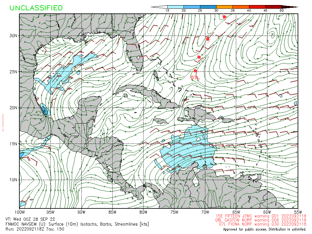
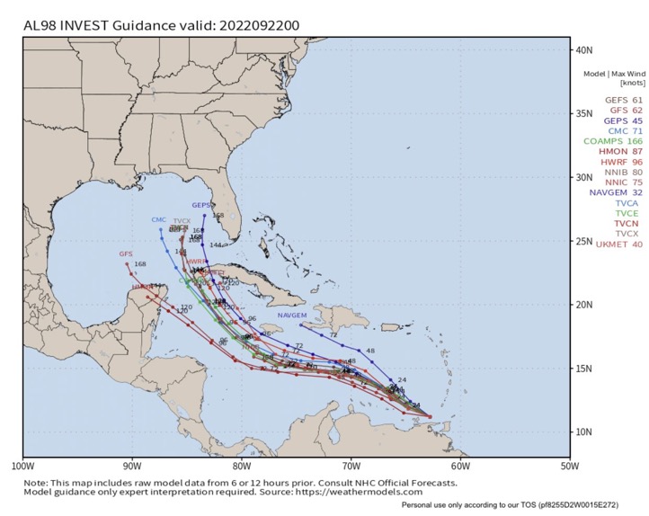
Not liking these continued westerly trends on successive model runs like the GFS is showing. I keep thinking it's possible to miss the trough and continue into the western GOM. That high over Texas should hold, but I don't like these west movements and having to bank on a hard NE turn at the end.
0 likes   
Personal Forecast Disclaimer:
The posts in this forum are NOT official forecast and should not be used as such. They are just the opinion of the poster and may or may not be backed by sound meteorological data. They are NOT endorsed by any professional institution or storm2k.org. For official information, please refer to the NHC and NWS products.


Return to “2022”

Who is online

Users browsing this forum: No registered users and 2 guests