
ATL: IAN - Models
Moderator: S2k Moderators
-
Keldeo1997
- Category 2

- Posts: 688
- Joined: Fri Oct 11, 2019 11:35 pm
Re: ATL: INVEST 98L - Models
Last edited by Keldeo1997 on Wed Sep 21, 2022 11:53 pm, edited 1 time in total.
0 likes

Re: ATL: INVEST 98L - Models
Cpv17 wrote:Pelicane wrote:Really hoping these eastward shifts stop. Louisiana's had enough of these storms.
You mean west..?
Yeah.
0 likes

Re: ATL: INVEST 98L - Models
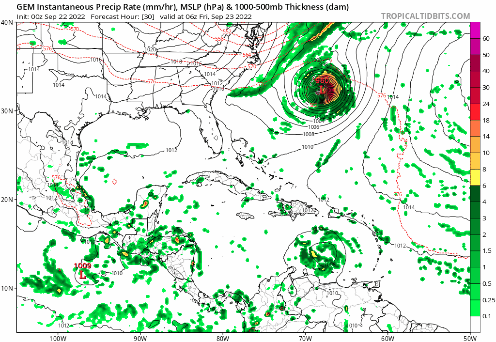
0Z UKMET at 144 is in SE GOM moving NNW after NW just before. This run ends to the west of the prior run.
TROPICAL DEPRESSION 98L ANALYSED POSITION : 9.8N 64.4W
ATCF IDENTIFIER : AL982022
LEAD CENTRAL MAXIMUM WIND
VERIFYING TIME TIME POSITION PRESSURE (MB) SPEED (KNOTS)
-------------- ---- -------- ------------- -------------
0000UTC 22.09.2022 0 9.8N 64.4W 1007 23
1200UTC 22.09.2022 12 11.2N 64.3W 1008 29
0000UTC 23.09.2022 24 12.5N 66.4W 1007 30
1200UTC 23.09.2022 36 13.9N 68.7W 1007 30
0000UTC 24.09.2022 48 14.5N 70.5W 1006 28
1200UTC 24.09.2022 60 14.8N 72.9W 1005 33
0000UTC 25.09.2022 72 15.1N 75.2W 1003 32
1200UTC 25.09.2022 84 16.3N 77.6W 1000 36
0000UTC 26.09.2022 96 18.1N 79.5W 997 41
1200UTC 26.09.2022 108 20.3N 81.6W 993 42
0000UTC 27.09.2022 120 21.7N 83.2W 992 42
1200UTC 27.09.2022 132 22.9N 84.4W 994 46
0000UTC 28.09.2022 144 24.0N 85.1W 992 51
Last edited by LarryWx on Thu Sep 22, 2022 12:03 am, edited 1 time in total.
0 likes
Personal Forecast Disclaimer:
The posts in this forum are NOT official forecasts and should not be used as such. They are just the opinion of the poster and may or may not be backed by sound meteorological data. They are NOT endorsed by any professional institution or storm2k.org. For official information, please refer to the NHC and NWS products.
The posts in this forum are NOT official forecasts and should not be used as such. They are just the opinion of the poster and may or may not be backed by sound meteorological data. They are NOT endorsed by any professional institution or storm2k.org. For official information, please refer to the NHC and NWS products.
-
AutoPenalti
- Category 5

- Posts: 4091
- Age: 29
- Joined: Mon Aug 17, 2015 4:16 pm
- Location: Ft. Lauderdale, Florida
Re: ATL: INVEST 98L - Models
Would not be surprised if the attention begins to shift back to Texas at this rate
0 likes
The posts in this forum are NOT official forecasts and should not be used as such. They are just the opinion of the poster and may or may not be backed by sound meteorological data. They are NOT endorsed by any professional institution or STORM2K. For official information, please refer to products from the NHC and NWS.
Model Runs Cheat Sheet:
GFS (5:30 AM/PM, 11:30 AM/PM)
HWRF, GFDL, UKMET, NAVGEM (6:30-8:00 AM/PM, 12:30-2:00 AM/PM)
ECMWF (1:45 AM/PM)
TCVN is a weighted averaged
Re: ATL: INVEST 98L - Models
IcyTundra wrote:At this rate the GFS is going to have 98L hitting Brownsville by the 0z run tommorow night. Right now it is the western outlier but I do find it odd that the usual east bias from the GFS isn't appearing.
I heard Levi's explanation of what might be causing the GFS more leftward track, but I'm not certain if it explains everything.
Apparently, the GFS is trying to develop 98L almost immediately. And, according to Levi, a more stacked system in the short term is more likely to "feel" Fiona's outflow pushing hard from the NE, which would impart onto 98L a quicker and more SW early track. Other models that are not trying to develop 98L so aggressively would be more liable to move a bit more slowly along the lower trade winds to the WNW.
Not sure if this explains all the track differences, but there it is
3 likes

Re: ATL: INVEST 98L - Models
AutoPenalti wrote:Would not be surprised if the attention begins to shift back to Texas at this rate
In late September? Highly doubt it. Not impossible but damn near it.
1 likes
Re: ATL: INVEST 98L - Models
sma10 wrote:IcyTundra wrote:At this rate the GFS is going to have 98L hitting Brownsville by the 0z run tommorow night. Right now it is the western outlier but I do find it odd that the usual east bias from the GFS isn't appearing.
I heard Levi's explanation of what might be causing the GFS more leftward track, but I'm not certain if it explains everything.
Apparently, the GFS is trying to develop 98L almost immediately. And, according to Levi, a more stacked system in the short term is more likely to "feel" Fiona's outflow pushing hard from the NE, which would impart onto 98L a quicker and more SW early track. Other models that are not trying to develop 98L so aggressively would be more liable to move a bit more slowly along the lower trade winds to the WNW.
Not sure if this explains all the track differences, but there it is
Makes sense the GFS usually develops and strengthens too quickly.
0 likes
-
CrazyC83
- Professional-Met

- Posts: 34315
- Joined: Tue Mar 07, 2006 11:57 pm
- Location: Deep South, for the first time!
Re: ATL: INVEST 98L - Models
It's going to be a very sensitive track based on the building ridge and the Northeast trough. I see why the CMC turns it and the GFS keeps going west - it has the trough only slightly weaker (the GFS) and that same model has a weaker, but broader, ridge. A stronger ridge would turn it too.
1 likes
Re: ATL: INVEST 98L - Models
LarryWx wrote:0Z UKMET at 144 is in SE GOM moving NNW after NW just before:
TROPICAL DEPRESSION 98L ANALYSED POSITION : 9.8N 64.4W
ATCF IDENTIFIER : AL982022
LEAD CENTRAL MAXIMUM WIND
VERIFYING TIME TIME POSITION PRESSURE (MB) SPEED (KNOTS)
-------------- ---- -------- ------------- -------------
0000UTC 22.09.2022 0 9.8N 64.4W 1007 23
1200UTC 22.09.2022 12 11.2N 64.3W 1008 29
0000UTC 23.09.2022 24 12.5N 66.4W 1007 30
1200UTC 23.09.2022 36 13.9N 68.7W 1007 30
0000UTC 24.09.2022 48 14.5N 70.5W 1006 28
1200UTC 24.09.2022 60 14.8N 72.9W 1005 33
0000UTC 25.09.2022 72 15.1N 75.2W 1003 32
1200UTC 25.09.2022 84 16.3N 77.6W 1000 36
0000UTC 26.09.2022 96 18.1N 79.5W 997 41
1200UTC 26.09.2022 108 20.3N 81.6W 993 42
0000UTC 27.09.2022 120 21.7N 83.2W 992 42
1200UTC 27.09.2022 132 22.9N 84.4W 994 46
0000UTC 28.09.2022 144 24.0N 85.1W 992 51
Just tracking this in my head, this appears to be relatively similar to Euro/CMC?
1 likes
Re: ATL: INVEST 98L - Models
Cpv17 wrote:AutoPenalti wrote:Would not be surprised if the attention begins to shift back to Texas at this rate
In late September? Highly doubt it. Not impossible but damn near it.
I agree if this was happening a month earlier or even 2 weeks ago it would be a bigger threat to Texas but with it being late September I don't see it happening. Rita came close to being a rare late September hit and there is a few others I'm forgetting but it is highly unlikely imo.
0 likes
-
AxaltaRacing24
- Category 5
- Posts: 1774
- Age: 25
- Joined: Wed Jul 27, 2016 11:14 am
- Location: Jupiter, FL
Re: ATL: INVEST 98L - Models
sma10 wrote:LarryWx wrote:0Z UKMET at 144 is in SE GOM moving NNW after NW just before:
TROPICAL DEPRESSION 98L ANALYSED POSITION : 9.8N 64.4W
ATCF IDENTIFIER : AL982022
LEAD CENTRAL MAXIMUM WIND
VERIFYING TIME TIME POSITION PRESSURE (MB) SPEED (KNOTS)
-------------- ---- -------- ------------- -------------
0000UTC 22.09.2022 0 9.8N 64.4W 1007 23
1200UTC 22.09.2022 12 11.2N 64.3W 1008 29
0000UTC 23.09.2022 24 12.5N 66.4W 1007 30
1200UTC 23.09.2022 36 13.9N 68.7W 1007 30
0000UTC 24.09.2022 48 14.5N 70.5W 1006 28
1200UTC 24.09.2022 60 14.8N 72.9W 1005 33
0000UTC 25.09.2022 72 15.1N 75.2W 1003 32
1200UTC 25.09.2022 84 16.3N 77.6W 1000 36
0000UTC 26.09.2022 96 18.1N 79.5W 997 41
1200UTC 26.09.2022 108 20.3N 81.6W 993 42
0000UTC 27.09.2022 120 21.7N 83.2W 992 42
1200UTC 27.09.2022 132 22.9N 84.4W 994 46
0000UTC 28.09.2022 144 24.0N 85.1W 992 51
Just tracking this in my head, this appears to be relatively similar to Euro/CMC?
Not going to lie, it is very strange to see the GFS being well west of the EURO/UKMET. Something has to give.
2 likes
Re: ATL: INVEST 98L - Models
AxaltaRacing24 wrote:sma10 wrote:LarryWx wrote:0Z UKMET at 144 is in SE GOM moving NNW after NW just before:
TROPICAL DEPRESSION 98L ANALYSED POSITION : 9.8N 64.4W
ATCF IDENTIFIER : AL982022
LEAD CENTRAL MAXIMUM WIND
VERIFYING TIME TIME POSITION PRESSURE (MB) SPEED (KNOTS)
-------------- ---- -------- ------------- -------------
0000UTC 22.09.2022 0 9.8N 64.4W 1007 23
1200UTC 22.09.2022 12 11.2N 64.3W 1008 29
0000UTC 23.09.2022 24 12.5N 66.4W 1007 30
1200UTC 23.09.2022 36 13.9N 68.7W 1007 30
0000UTC 24.09.2022 48 14.5N 70.5W 1006 28
1200UTC 24.09.2022 60 14.8N 72.9W 1005 33
0000UTC 25.09.2022 72 15.1N 75.2W 1003 32
1200UTC 25.09.2022 84 16.3N 77.6W 1000 36
0000UTC 26.09.2022 96 18.1N 79.5W 997 41
1200UTC 26.09.2022 108 20.3N 81.6W 993 42
0000UTC 27.09.2022 120 21.7N 83.2W 992 42
1200UTC 27.09.2022 132 22.9N 84.4W 994 46
0000UTC 28.09.2022 144 24.0N 85.1W 992 51
Just tracking this in my head, this appears to be relatively similar to Euro/CMC?
Not going to lie, it is very strange to see the GFS being well west of the EURO/UKMET. Something has to give.
Yeah, but ironically, this *could* be the same GFS bias as usual, but producing the opposite effect.
I say *could* because it's been performing well lately, and maybe it's correct in this thing taking off sooner, rather than later
0 likes
Re: ATL: INVEST 98L - Models
sma10 wrote:LarryWx wrote:0Z UKMET at 144 is in SE GOM moving NNW after NW just before:
TROPICAL DEPRESSION 98L ANALYSED POSITION : 9.8N 64.4W
ATCF IDENTIFIER : AL982022
LEAD CENTRAL MAXIMUM WIND
VERIFYING TIME TIME POSITION PRESSURE (MB) SPEED (KNOTS)
-------------- ---- -------- ------------- -------------
0000UTC 22.09.2022 0 9.8N 64.4W 1007 23
1200UTC 22.09.2022 12 11.2N 64.3W 1008 29
0000UTC 23.09.2022 24 12.5N 66.4W 1007 30
1200UTC 23.09.2022 36 13.9N 68.7W 1007 30
0000UTC 24.09.2022 48 14.5N 70.5W 1006 28
1200UTC 24.09.2022 60 14.8N 72.9W 1005 33
0000UTC 25.09.2022 72 15.1N 75.2W 1003 32
1200UTC 25.09.2022 84 16.3N 77.6W 1000 36
0000UTC 26.09.2022 96 18.1N 79.5W 997 41
1200UTC 26.09.2022 108 20.3N 81.6W 993 42
0000UTC 27.09.2022 120 21.7N 83.2W 992 42
1200UTC 27.09.2022 132 22.9N 84.4W 994 46
0000UTC 28.09.2022 144 24.0N 85.1W 992 51
Just tracking this in my head, this appears to be relatively similar to Euro/CMC?
Yes although a bit west of them and 200+ miles west of its prior run, which was hitting S FL from the south.
1 likes
Personal Forecast Disclaimer:
The posts in this forum are NOT official forecasts and should not be used as such. They are just the opinion of the poster and may or may not be backed by sound meteorological data. They are NOT endorsed by any professional institution or storm2k.org. For official information, please refer to the NHC and NWS products.
The posts in this forum are NOT official forecasts and should not be used as such. They are just the opinion of the poster and may or may not be backed by sound meteorological data. They are NOT endorsed by any professional institution or storm2k.org. For official information, please refer to the NHC and NWS products.

Re: ATL: INVEST 98L - Models
LarryWx wrote:sma10 wrote:LarryWx wrote:0Z UKMET at 144 is in SE GOM moving NNW after NW just before:
TROPICAL DEPRESSION 98L ANALYSED POSITION : 9.8N 64.4W
ATCF IDENTIFIER : AL982022
LEAD CENTRAL MAXIMUM WIND
VERIFYING TIME TIME POSITION PRESSURE (MB) SPEED (KNOTS)
-------------- ---- -------- ------------- -------------
0000UTC 22.09.2022 0 9.8N 64.4W 1007 23
1200UTC 22.09.2022 12 11.2N 64.3W 1008 29
0000UTC 23.09.2022 24 12.5N 66.4W 1007 30
1200UTC 23.09.2022 36 13.9N 68.7W 1007 30
0000UTC 24.09.2022 48 14.5N 70.5W 1006 28
1200UTC 24.09.2022 60 14.8N 72.9W 1005 33
0000UTC 25.09.2022 72 15.1N 75.2W 1003 32
1200UTC 25.09.2022 84 16.3N 77.6W 1000 36
0000UTC 26.09.2022 96 18.1N 79.5W 997 41
1200UTC 26.09.2022 108 20.3N 81.6W 993 42
0000UTC 27.09.2022 120 21.7N 83.2W 992 42
1200UTC 27.09.2022 132 22.9N 84.4W 994 46
0000UTC 28.09.2022 144 24.0N 85.1W 992 51
Just tracking this in my head, this appears to be relatively similar to Euro/CMC?
Yes although a bit west of them and 200+ miles west of its prior run, which was hitting S FL from the south.
Thanks, yes agreed. And certainly much further NE than GFS
0 likes
-
PTrackerLA

- Category 5
- Posts: 5281
- Age: 42
- Joined: Thu Oct 10, 2002 8:40 pm
- Location: Lafayette, LA
Re: ATL: INVEST 98L - Models
IcyTundra wrote:Cpv17 wrote:AutoPenalti wrote:Would not be surprised if the attention begins to shift back to Texas at this rate
In late September? Highly doubt it. Not impossible but damn near it.
I agree if this was happening a month earlier or even 2 weeks ago it would be a bigger threat to Texas but with it being late September I don't see it happening. Rita came close to being a rare late September hit and there is a few others I'm forgetting but it is highly unlikely imo.
Hurricane Delta made landfall about 50 miles east of the TX/LA border on 10/10/2020. Also interesting to note, Hurricane Lili made landfall roughly 60 miles west of the 00z landfall point 20 years ago minus 1 day on October 3, 2002.
5 likes
Re: ATL: INVEST 98L - Models
PTrackerLA wrote:IcyTundra wrote:Cpv17 wrote:
In late September? Highly doubt it. Not impossible but damn near it.
I agree if this was happening a month earlier or even 2 weeks ago it would be a bigger threat to Texas but with it being late September I don't see it happening. Rita came close to being a rare late September hit and there is a few others I'm forgetting but it is highly unlikely imo.
Hurricane Delta made landfall about 50 miles east of the TX/LA border on 10/10/2020. Also interesting to note, Hurricane Lili made landfall roughly 60 miles west of the 00z landfall point 20 years ago minus 1 day on October 3, 2002.
Yeah but it’s still highly unlikely.
0 likes
Re: ATL: INVEST 98L - Models
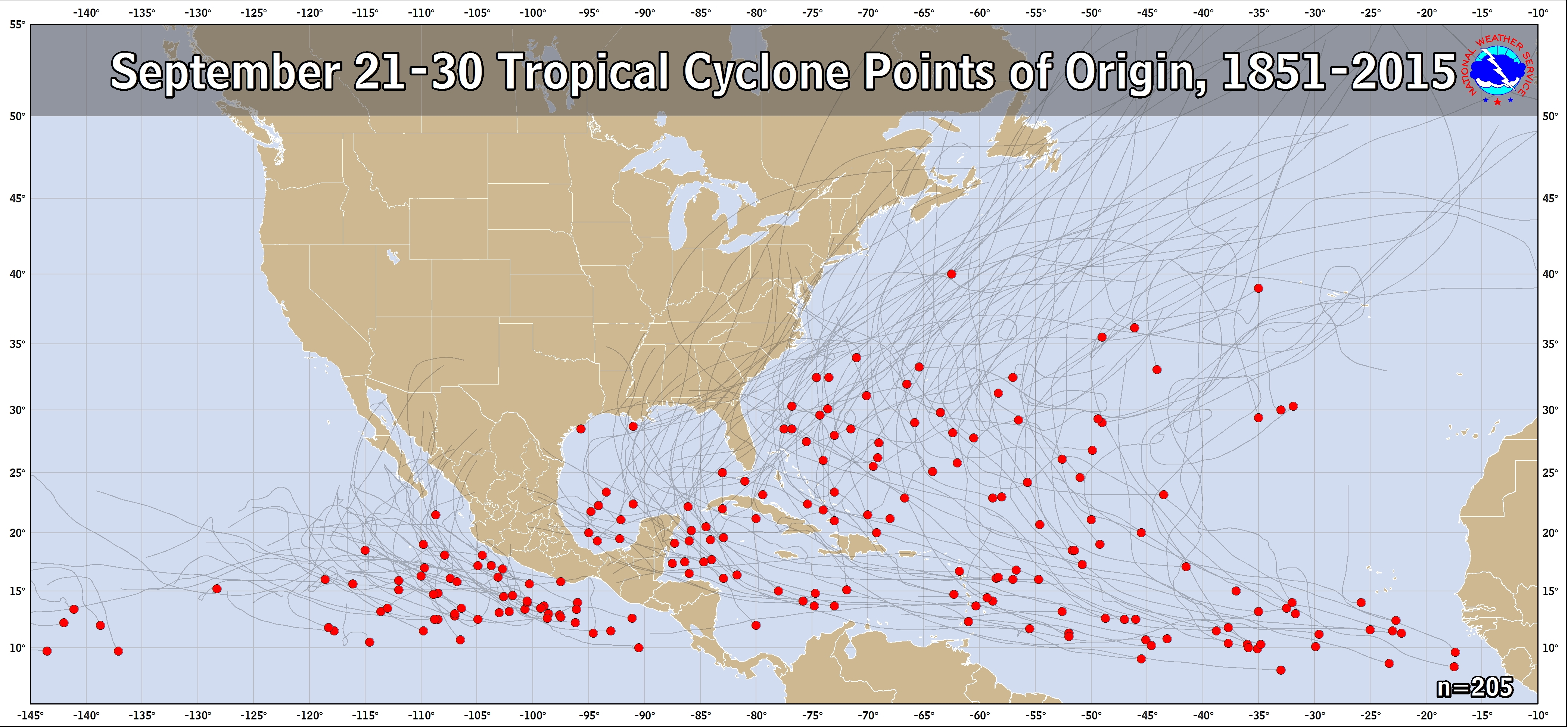
Regarding TCs that were born in the Caribbean during 9/21-30 1851-2015, climo says Gulf LA eastward to FL is easily the most likely destination although a pretty good number also go WNW into MX after either crossing the Yucatan or going just N of it.
https://www.nhc.noaa.gov/climo/images/sep_21_30.png
https://www.nhc.noaa.gov/climo/images/sep_21_30.png
5 likes
Personal Forecast Disclaimer:
The posts in this forum are NOT official forecasts and should not be used as such. They are just the opinion of the poster and may or may not be backed by sound meteorological data. They are NOT endorsed by any professional institution or storm2k.org. For official information, please refer to the NHC and NWS products.
The posts in this forum are NOT official forecasts and should not be used as such. They are just the opinion of the poster and may or may not be backed by sound meteorological data. They are NOT endorsed by any professional institution or storm2k.org. For official information, please refer to the NHC and NWS products.

Re: ATL: INVEST 98L - Models
Cpv17 wrote:PTrackerLA wrote:IcyTundra wrote:
I agree if this was happening a month earlier or even 2 weeks ago it would be a bigger threat to Texas but with it being late September I don't see it happening. Rita came close to being a rare late September hit and there is a few others I'm forgetting but it is highly unlikely imo.
Hurricane Delta made landfall about 50 miles east of the TX/LA border on 10/10/2020. Also interesting to note, Hurricane Lili made landfall roughly 60 miles west of the 00z landfall point 20 years ago minus 1 day on October 3, 2002.
Yeah but it’s still highly unlikely.
I'm glad you're comfortable, for some reason I'm not.
The GEFS has some decent member agreement for splitting the gap and heading into the central GOM.
0 likes
Personal Forecast Disclaimer:
The posts in this forum are NOT official forecast and should not be used as such. They are just the opinion of the poster and may or may not be backed by sound meteorological data. They are NOT endorsed by any professional institution or storm2k.org. For official information, please refer to the NHC and NWS products.
The posts in this forum are NOT official forecast and should not be used as such. They are just the opinion of the poster and may or may not be backed by sound meteorological data. They are NOT endorsed by any professional institution or storm2k.org. For official information, please refer to the NHC and NWS products.
Re: ATL: INVEST 98L - Models
IcyTundra wrote:Cpv17 wrote:AutoPenalti wrote:Would not be surprised if the attention begins to shift back to Texas at this rate
In late September? Highly doubt it. Not impossible but damn near it.
I agree if this was happening a month earlier or even 2 weeks ago it would be a bigger threat to Texas but with it being late September I don't see it happening. Rita came close to being a rare late September hit and there is a few others I'm forgetting but it is highly unlikely imo.
While I know Rita was technically a SW LA hit, if you look at the track, it made landfall in that tiny corner of SW LA that kind of sticks out to the west "into" Texas. The effects were devastating here in SE TX as well as SW LA. With that said, I consider that a late hit for Texas and doubt anything would hit this far west any later. 98L will likely be an issue for Louisiana eastward.

0 likes
Who is online
Users browsing this forum: No registered users and 32 guests