ATL: IAN - Models
Moderator: S2k Moderators
-
otowntiger
- Category 5

- Posts: 1932
- Joined: Tue Aug 31, 2004 7:06 pm
Re: ATL: INVEST 98L - Models
Seems that GFS continues to shift west with each run lately. The chasm between it and Euro seems to as wide as ever. Although the Euro is starting to creep a bit west itself.
0 likes
-
wicked_wx_watcher
- Tropical Depression

- Posts: 53
- Joined: Sat Jan 13, 2007 12:56 pm
- Location: Clear Lake City/Webster, TX
Re: ATL: INVEST 98L - Models
kassi wrote:IcyTundra wrote:Cpv17 wrote:
In late September? Highly doubt it. Not impossible but damn near it.
I agree if this was happening a month earlier or even 2 weeks ago it would be a bigger threat to Texas but with it being late September I don't see it happening. Rita came close to being a rare late September hit and there is a few others I'm forgetting but it is highly unlikely imo.
While I know Rita was technically a SW LA hit, if you look at the track, it made landfall in that tiny corner of SW LA that kind of sticks out to the west "into" Texas. The effects were devastating here in SE TX as well as SW LA. With that said, I consider that a late hit for Texas and doubt anything would hit this far west any later. 98L will likely be an issue for Louisiana eastward.
[url]https://i.ibb.co/bQr81Yv/20220922-003032.jpg [/url]
You are absolutely correct about Rita. From Jefferson & Orange Counties, tracking through the piney woods of east Texas, Rita’s destruction was widespread. Compounding the mental anguish, this area was full of displaced Katrina families who were forced to evac a 2nd time in less than a month. It took 3 weeks+ to get power back in higher populated areas.
2 likes
-
Iceresistance

- Category 5
- Posts: 9591
- Age: 22
- Joined: Sat Oct 10, 2020 9:45 am
- Location: Tecumseh, OK/Norman, OK
Re: ATL: INVEST 98L - Models
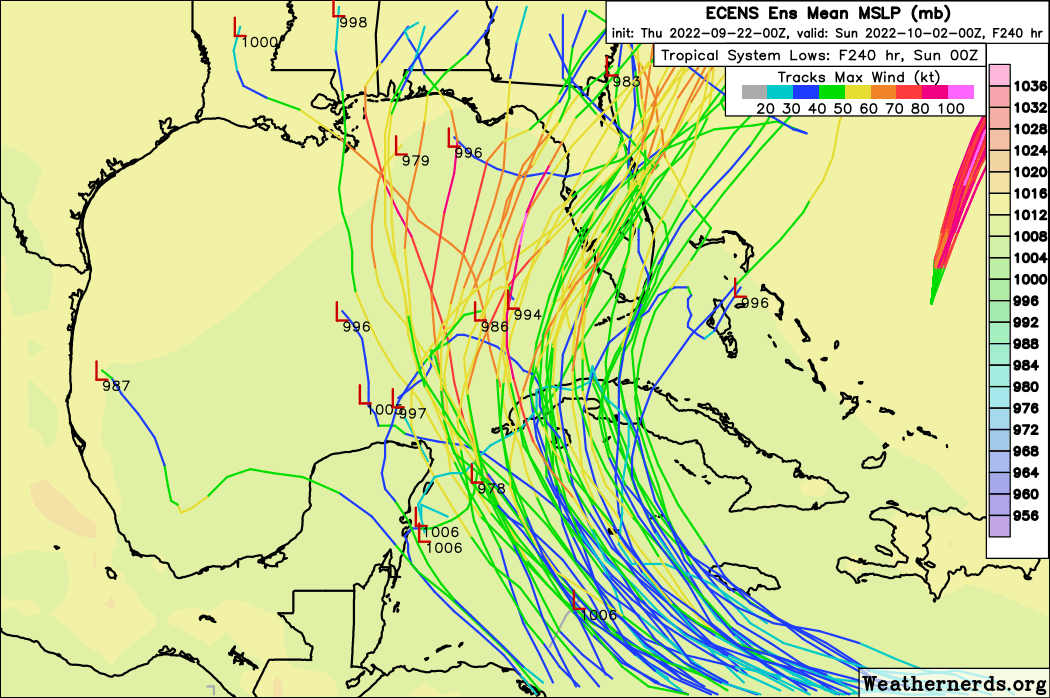
Mean 0Z GEFS is between the Yucatan and Cuba, another west shift.
0 likes
Bill 2015 & Beta 2020
Winter 2020-2021
All observations are in Tecumseh, OK unless otherwise noted.
Winter posts are focused mainly for Oklahoma & Texas.
Take any of my forecasts with a grain of salt, refer to the NWS, SPC, and NHC for official information
Never say Never with weather! Because ANYTHING is possible!
Winter 2020-2021
All observations are in Tecumseh, OK unless otherwise noted.
Winter posts are focused mainly for Oklahoma & Texas.
Take any of my forecasts with a grain of salt, refer to the NWS, SPC, and NHC for official information
Never say Never with weather! Because ANYTHING is possible!


Re: ATL: INVEST 98L - Models
Iceresistance wrote:Mean 0Z GEFS is between the Yucatan and Cuba, another west shift.
06Z GFS crosses the Yucatan peninsula but the land interaction doesn't slow it down much.
0 likes
-
chris_fit

- Category 5
- Posts: 3261
- Age: 43
- Joined: Wed Sep 10, 2003 11:58 pm
- Location: Tampa Bay Area, FL
Re: ATL: INVEST 98L - Models
Looking at the 500mb heights - Just not understanding how this does not go more N on the 06z GFS at hours 90-144

0 likes

Re: ATL: INVEST 98L - Models
A few more southward shifts on the GFS and it's going to end up in the Pacific
5 likes
The above post is not official and should not be used as such. It is the opinion of the poster and may or may not be backed by sound meteorological data. It is not endorsed by any professional institution or storm2k.org. For official information, please refer to the NHC and NWS products.
-
Ivanhater

- Storm2k Moderator

- Posts: 11221
- Age: 39
- Joined: Fri Jul 01, 2005 8:25 am
- Location: Pensacola
Re: ATL: INVEST 98L - Models
chris_fit wrote:Looking at the 500mb heights - Just not understanding how this does not go more N on the 06z GFS at hours 90-144
https://i.imgur.com/XtirmBH.gif
Because the 588 ridge builds right over the Florida peninsula as the trough lifts out keeping it west.
Not saying it is right but the blend of models and TVCN has been consistent
0 likes
Michael


-
Keldeo1997
- Category 2

- Posts: 688
- Joined: Fri Oct 11, 2019 11:35 pm


-
Keldeo1997
- Category 2
- Posts: 688
- Joined: Fri Oct 11, 2019 11:35 pm


Re: ATL: INVEST 98L - Models
So overnight 6z GFS near Lake Charles 10/2, Euro is north of Tampa next Thursday, CMC is Naples on Tuesday, with the UKMET and TVCN consensus in the East Gulf. Looks like it's weighted to the eastern Gulf/Florida this morning.
Last edited by BobHarlem on Thu Sep 22, 2022 6:09 am, edited 3 times in total.
0 likes
-
hurricane2025
- Category 1

- Posts: 254
- Joined: Thu Apr 08, 2021 10:36 am

-
jlauderdal
- S2K Supporter

- Posts: 7240
- Joined: Wed May 19, 2004 5:46 am
- Location: NE Fort Lauderdale
- Contact:
Re: ATL: INVEST 98L - Models
hurricane2025 wrote:We need a center
In a few of days we will get additional balloon launches, planes in and around this almost constantly and a center to work with, by Saturday afternoon we should know who needs to panic
1 likes
Who is online
Users browsing this forum: No registered users and 36 guests