ATL: IAN - Models
Moderator: S2k Moderators

-
jlauderdal
- S2K Supporter

- Posts: 7240
- Joined: Wed May 19, 2004 5:46 am
- Location: NE Fort Lauderdale
- Contact:
Re: ATL: INVEST 98L - Models
Classic gfs vs euro, they just see things differently and that's expected at this range, take the middle of the two solutions for now.
0 likes

Re: ATL: INVEST 98L - Models
It’s so weird seeing the Euro and CMC being the NE/right-shifted models and the GFS being the SW/left-shifted model with 98L. Too early to tell if the GFS is going to be right about the track again and all the other models will correct towards it, or if it’s getting something wrong.
The 0z HWRF looks to split the difference between the globals and has a landfall on the very northernmost tip of the Yucatan, nearly missing land entirely and passing through the channel. It seems to be a little slower as well.
The 0z HWRF looks to split the difference between the globals and has a landfall on the very northernmost tip of the Yucatan, nearly missing land entirely and passing through the channel. It seems to be a little slower as well.
0 likes
Irene '11 Sandy '12 Hermine '16 5/15/2018 Derecho Fay '20 Isaias '20 Elsa '21 Henri '21 Ida '21
I am only a meteorology enthusiast who knows a decent amount about tropical cyclones. Look to the professional mets, the NHC, or your local weather office for the best information.
I am only a meteorology enthusiast who knows a decent amount about tropical cyclones. Look to the professional mets, the NHC, or your local weather office for the best information.

Re: ATL: INVEST 98L - Models
chris_fit wrote:Looking at the 500mb heights - Just not understanding how this does not go more N on the 06z GFS at hours 90-144
https://i.imgur.com/XtirmBH.gif
Because the GFS has a slow and low riding system deep south in the Caribbean. The more west it travels in the southern Caribbean the less effect the trough will have on it. For all intents, most of the models already had 98L developed into a storm and having gained a decent amount of latitude. It has continued to stay far south and has not intensified to TS status.
0 likes
-
tolakram
- Admin

- Posts: 20186
- Age: 62
- Joined: Sun Aug 27, 2006 8:23 pm
- Location: Florence, KY (name is Mark)
Re: ATL: INVEST 98L - Models
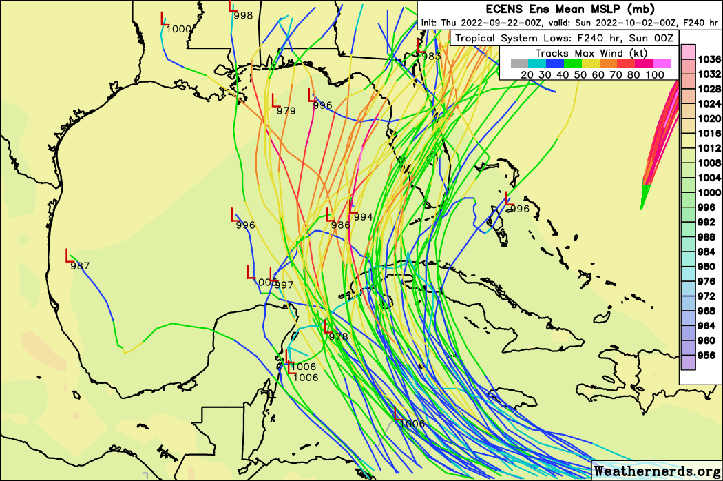
Poor GFS, all by itself out west.
Here's the 200MB level, upper level forecast different (of course) for GFS and Euro.


Here's the 200MB level, upper level forecast different (of course) for GFS and Euro.
0 likes
M a r k
- - - - -
Join us in chat: Storm2K Chatroom Invite. Android and IOS apps also available.
The posts in this forum are NOT official forecasts and should not be used as such. Posts are NOT endorsed by any professional institution or STORM2K.org. For official information and forecasts, please refer to NHC and NWS products.
-
Blown Away

- S2K Supporter
- Posts: 10253
- Joined: Wed May 26, 2004 6:17 am
Re: ATL: INVEST 98L - Models
jlauderdal wrote:
Classic gfs vs euro, they just see things differently and that's expected at this range, take the middle of the two solutions for now.
But when it comes to a forecasted CONUS landfall they will come together at some point and one of those models will be very wrong.
Interesting twist with 98L, not sure I can remember this much disagreement in the mid range between the two big models and both swapping their bias.
0 likes
Hurricane Eye Experience: David 79, Irene 99, Frances 04, Jeanne 04, Wilma 05… Hurricane Brush Experience: Andrew 92, Erin 95, Floyd 99, Matthew 16, Irma 17, Ian 22, Nicole 22…
-
Blown Away
- S2K Supporter
- Posts: 10253
- Joined: Wed May 26, 2004 6:17 am
Re: ATL: INVEST 98L - Models

06z HWRF... E shift through 80 hrs, coming close to Jamaica this run...
0 likes
Hurricane Eye Experience: David 79, Irene 99, Frances 04, Jeanne 04, Wilma 05… Hurricane Brush Experience: Andrew 92, Erin 95, Floyd 99, Matthew 16, Irma 17, Ian 22, Nicole 22…
Re: ATL: INVEST 98L - Models
Blown Away wrote:https://i.imgur.com/0OouWuT.gif
06z HWRF... E shift through 80 hrs, coming close to Jamaica this run...
Anyone able to tell what intensity HWRF takes it to?
0 likes
-
Blown Away
- S2K Supporter
- Posts: 10253
- Joined: Wed May 26, 2004 6:17 am
Re: ATL: INVEST 98L - Models
caneman wrote:Blown Away wrote:https://i.imgur.com/0OouWuT.gif
06z HWRF... E shift through 80 hrs, coming close to Jamaica this run...
Anyone able to tell what intensity HWRF takes it to?
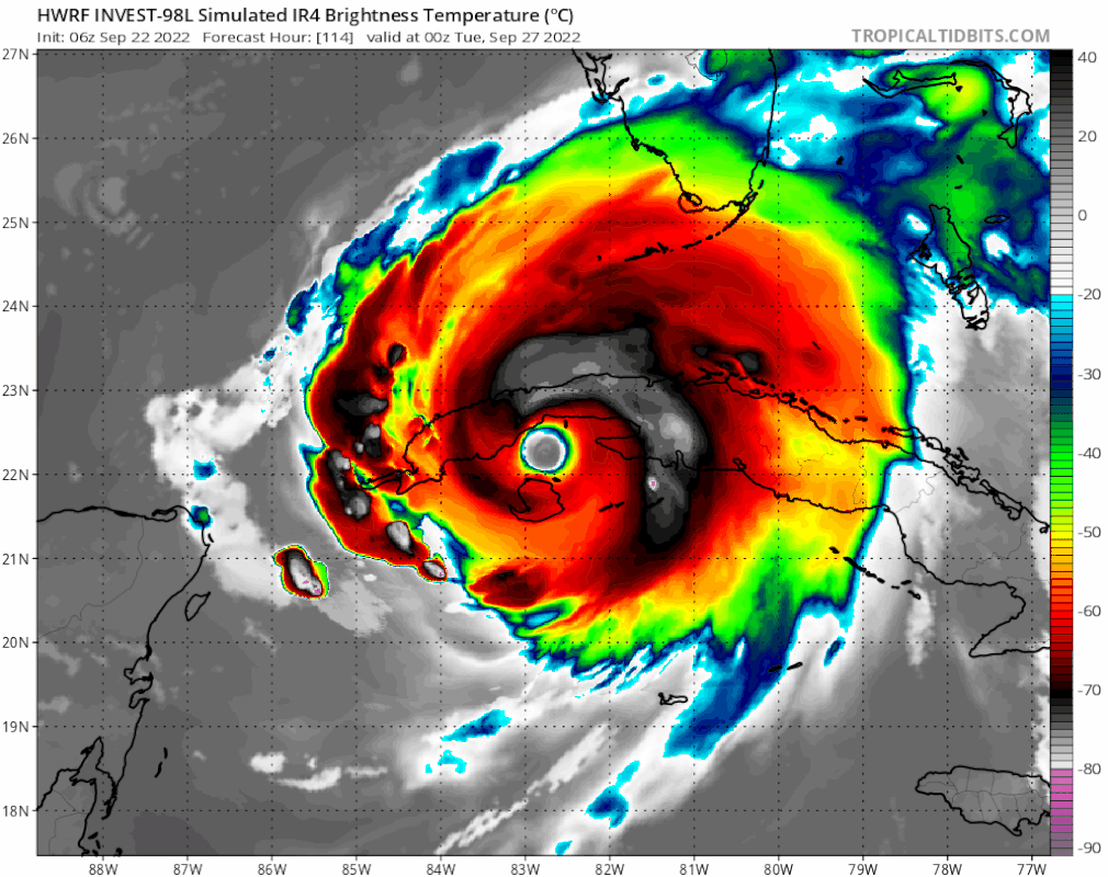
@90 hrs. 987 mb, solid Cat 1
1 likes
Hurricane Eye Experience: David 79, Irene 99, Frances 04, Jeanne 04, Wilma 05… Hurricane Brush Experience: Andrew 92, Erin 95, Floyd 99, Matthew 16, Irma 17, Ian 22, Nicole 22…
-
tolakram
- Admin
- Posts: 20186
- Age: 62
- Joined: Sun Aug 27, 2006 8:23 pm
- Location: Florence, KY (name is Mark)
Re: ATL: INVEST 98L - Models
HWRF so far

3 likes
M a r k
- - - - -
Join us in chat: Storm2K Chatroom Invite. Android and IOS apps also available.
The posts in this forum are NOT official forecasts and should not be used as such. Posts are NOT endorsed by any professional institution or STORM2K.org. For official information and forecasts, please refer to NHC and NWS products.
- - - - -
Join us in chat: Storm2K Chatroom Invite. Android and IOS apps also available.
The posts in this forum are NOT official forecasts and should not be used as such. Posts are NOT endorsed by any professional institution or STORM2K.org. For official information and forecasts, please refer to NHC and NWS products.
-
Weatherboy1

- Category 5

- Posts: 1190
- Age: 50
- Joined: Mon Jul 05, 2004 1:50 pm
- Location: Jupiter/Sarasota, FL
Re: ATL: INVEST 98L - Models
Blown Away wrote:jlauderdal wrote:
Classic gfs vs euro, they just see things differently and that's expected at this range, take the middle of the two solutions for now.
But when it comes to a forecasted CONUS landfall they will come together at some point and one of those models will be very wrong.
Interesting twist with 98L, not sure I can remember this much disagreement in the mid range between the two big models and both swapping their bias.
I tend to agree this is going to be more of a “one of these models is going to be a mega-bust” situation, vs. one where they (GFS and Euro) gradually come to the middle. Now that we’re getting closer to October Vs. August/early September, I tend to give more weight to the idea of a deeper trough/further south frontal push. So I’d lean more toward a euro-style solution here than GFS
2 likes


-
hurricane2025
- Category 1

- Posts: 254
- Joined: Thu Apr 08, 2021 10:36 am
-
Jelmergraaff
- Tropical Storm

- Posts: 138
- Age: 23
- Joined: Fri Aug 27, 2021 1:00 pm
- Location: The Netherlands
Re: ATL: INVEST 98L - Models
caneman wrote:Blown Away wrote:https://i.imgur.com/0OouWuT.gif
06z HWRF... E shift through 80 hrs, coming close to Jamaica this run...
Anyone able to tell what intensity HWRF takes it to?
At +99h a MH with 102 kts and a minimum pressure of 954 mb.

1 likes
21-year old meteorologist and student MSc Climate Studies from The Netherlands. Interested in all fields of meteorology and climatology, including tropical systems like hurricanes.
-
Category5Kaiju

- Category 5
- Posts: 4334
- Joined: Thu Dec 24, 2020 12:45 pm
- Location: Seattle and Phoenix
Re: ATL: INVEST 98L - Models
caneseddy wrote:JB’s take
https://twitter.com/BigJoeBastardi/status/1572877345387851776?s=20&t=STaO4BpsP4LEbJbWJQvQsA
Genuinely curious, but when did this thing receive a name (he mentions “Hermine” it seems); I thought we had multiple areas competing for that name as well?
Anyhow, I really think unless a center forms, it’s basically up in the air regarding where this thing goes
0 likes
Unless explicitly stated, all info in my posts is based on my own opinions and observations. Tropical storms and hurricanes can be extremely dangerous. Refer to an accredited weather research agency or meteorologist if you need to make serious decisions regarding an approaching storm.
-
tolakram
- Admin
- Posts: 20186
- Age: 62
- Joined: Sun Aug 27, 2006 8:23 pm
- Location: Florence, KY (name is Mark)
Re: ATL: INVEST 98L - Models
Category5Kaiju wrote:caneseddy wrote:JB’s take
https://twitter.com/BigJoeBastardi/status/1572877345387851776?s=20&t=STaO4BpsP4LEbJbWJQvQsA
Genuinely curious, but when did this thing receive a name (he mentions “Hermine” it seems); I thought we had multiple areas competing for that name as well?
Anyhow, I really think unless a center forms, it’s basically up in the air regarding where this thing goes
You will have to ask him but how about we don't start a conversation on a JB tweet please.

1 likes
M a r k
- - - - -
Join us in chat: Storm2K Chatroom Invite. Android and IOS apps also available.
The posts in this forum are NOT official forecasts and should not be used as such. Posts are NOT endorsed by any professional institution or STORM2K.org. For official information and forecasts, please refer to NHC and NWS products.
- - - - -
Join us in chat: Storm2K Chatroom Invite. Android and IOS apps also available.
The posts in this forum are NOT official forecasts and should not be used as such. Posts are NOT endorsed by any professional institution or STORM2K.org. For official information and forecasts, please refer to NHC and NWS products.

Re: ATL: INVEST 98L - Models
3090 wrote:For all intents, most of the models already had 98L developed into a storm and having gained a decent amount of latitude. It has continued to stay far south and has not intensified to TS status.
None of the model showed significant development until this weekend, when the storm is south of Hispaniola. If its still to South America Saturday evening then we will have give the GFS credit.
Given the water near west Cuba and southern Gulf, this will have the potential to RI as it approaches the CONUS, Yucatan/Cuba so later development does not mean a weaker storm down the road.
That said, its looking a little better this morning, I was feeling a little silly to be so concerned about a disorganized cluster of showers. I don't expect a YD until Saturday.
4 likes
Who is online
Users browsing this forum: No registered users and 8 guests