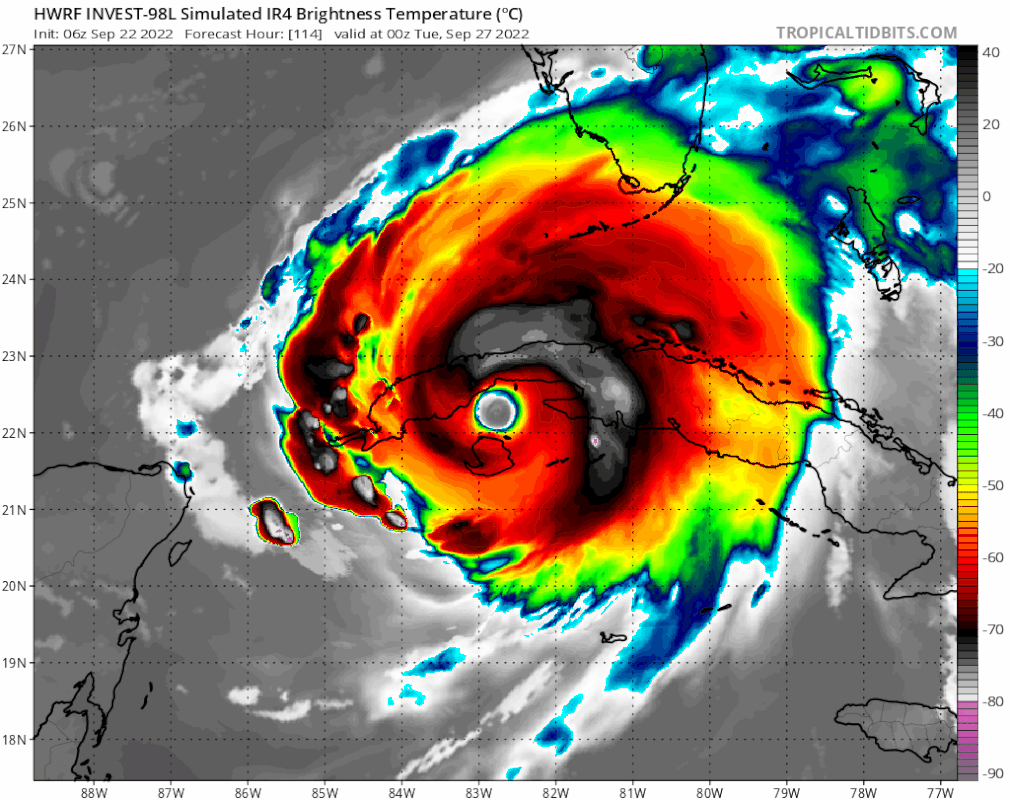
That HWRF run has this thing getting super intense prior to Cuba. Looks to be near cat 4ish, am I right? That seems to me to be rather ambitious given how its not really supposed to begin pulling itself together until it actually gets into the western/North western Caribbean.SFLcane wrote:06z with a big shift north and east.
https://i.postimg.cc/qMq1hxfF/FAA94-FD4-C94-A-40-F4-9-F41-AF1-D2394-C7-BE.gif
ATL: IAN - Models
Moderator: S2k Moderators
-
otowntiger
- Category 5

- Posts: 1932
- Joined: Tue Aug 31, 2004 7:06 pm
Re: ATL: INVEST 98L - Models
0 likes
Re: ATL: INVEST 98L - Models
Keldeo1997 wrote:https://cdn.discordapp.com/attachments/752166055501365319/1022365985925247008/unknown.png
It would be stalling right over that Warm pool in the gulf
And that makes the lack of strong intensity curious.
0 likes
Cleo - 1964, Betsy - 1965, David - 1979, Andrew - 1992, Charlie (Francis, Ivan, Jeanne) - 2004, Irma - 2017, Ian - 2022, Milton - 2024


Re: ATL: INVEST 98L - Models
Find it interesting that the very first post of the 06Z GFS 20SEP22 is identical to 00Z EURO this morning FWIW 
0 likes
Once I see the REDS and GREENS Converge on a Base Velocity. ... I'm There!!
This is NOT an Official Forecast....Just my Opinion. For official information, please refer to the NHC and NWS products.
HIGHLIGHTS : '13 El Reno Tornado : 2013 Storm Chaser Tour, Joaquin; SC flood event, Matthew '16, Lowcountry Snow storm Jan '18
This is NOT an Official Forecast....Just my Opinion. For official information, please refer to the NHC and NWS products.
HIGHLIGHTS : '13 El Reno Tornado : 2013 Storm Chaser Tour, Joaquin; SC flood event, Matthew '16, Lowcountry Snow storm Jan '18
-
Poonwalker
- Category 1

- Posts: 270
- Joined: Tue Sep 20, 2022 11:12 am

-
SFLcane

- S2K Supporter

- Posts: 10281
- Age: 48
- Joined: Sat Jun 05, 2010 1:44 pm
- Location: Lake Worth Florida
Re: ATL: INVEST 98L - Models
Somebody is out lunch! Surely we find out in a few days.

Last edited by SFLcane on Thu Sep 22, 2022 7:42 am, edited 1 time in total.
0 likes
-
gatorcane

- S2K Supporter
- Posts: 23708
- Age: 48
- Joined: Sun Mar 13, 2005 3:54 pm
- Location: Boca Raton, FL
Re: ATL: INVEST 98L - Models
SFLcane wrote:06z with a big shift north and east.
https://i.postimg.cc/qMq1hxfF/FAA94-FD4-C94-A-40-F4-9-F41-AF1-D2394-C7-BE.gif
Consensus of the GFS and Euro is the best bet and the track is quite a bit further west. As usual the HWRF is way too intense too quickly. Not looking like a FL peninsula threat still, but we will know more by the weekend.
Last edited by gatorcane on Thu Sep 22, 2022 7:43 am, edited 2 times in total.
3 likes
-
otowntiger
- Category 5
- Posts: 1932
- Joined: Tue Aug 31, 2004 7:06 pm
Re: ATL: INVEST 98L - Models
And WAAAY West! Amazing how persistent and determined the GFS is to get this that close to Texas.Poonwalker wrote:N2FSU wrote:https://uploads.tapatalk-cdn.com/20220922/76e8a42220238b23e565957253d0fda6.jpg
That’s massive!
Sent from my iPad using Tapatalk
0 likes
-
Blown Away

- S2K Supporter
- Posts: 10253
- Joined: Wed May 26, 2004 6:17 am
Re: ATL: INVEST 98L - Models


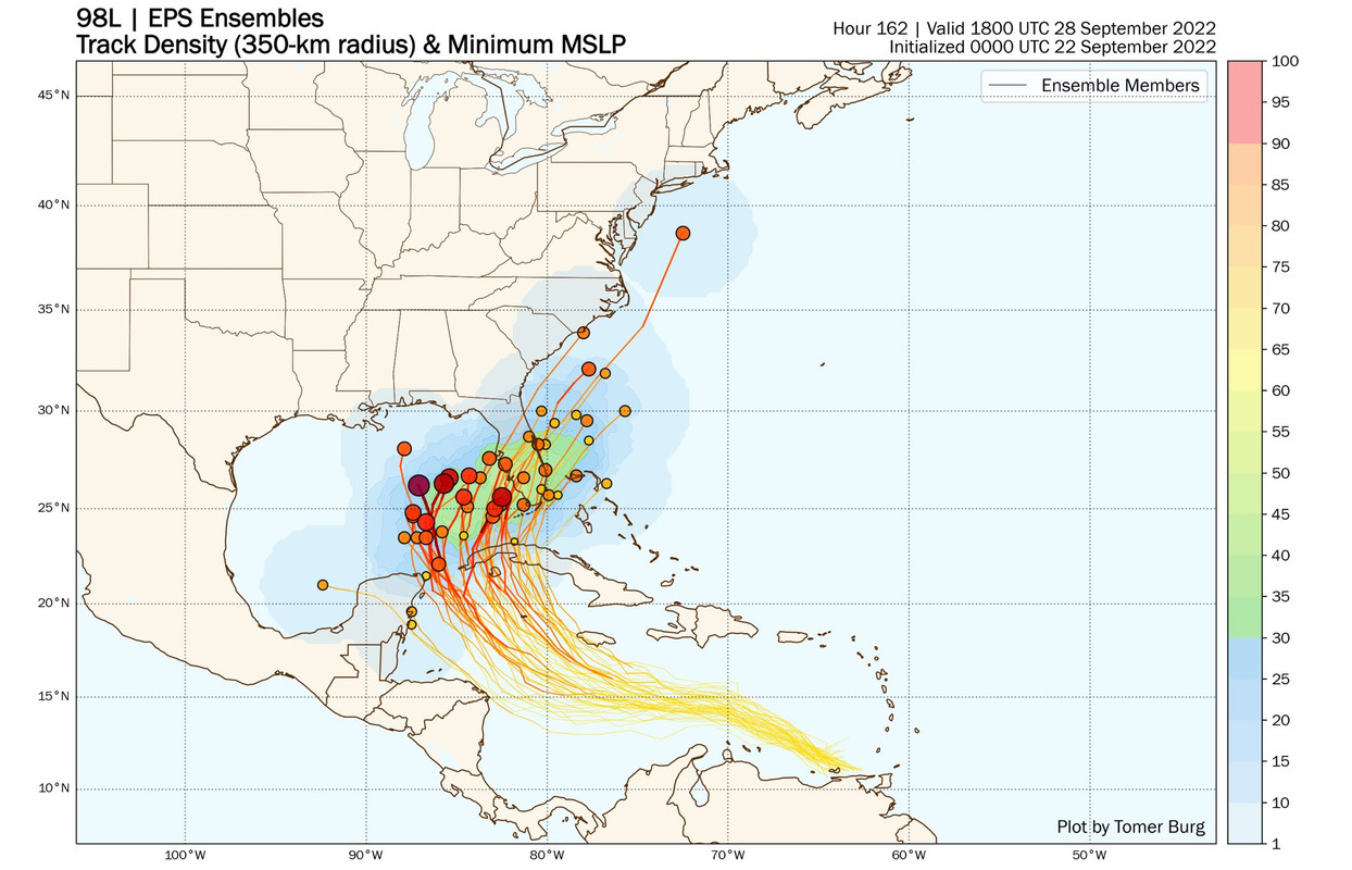
06z ECMWF... At 72 hours ECMWF is @125 mile NE of 06z GFS... Big spread in close range IMO...
0 likes
Hurricane Eye Experience: David 79, Irene 99, Frances 04, Jeanne 04, Wilma 05… Hurricane Brush Experience: Andrew 92, Erin 95, Floyd 99, Matthew 16, Irma 17, Ian 22, Nicole 22…
-
Tireman4

- S2K Supporter
- Posts: 5903
- Age: 60
- Joined: Fri Jun 30, 2006 1:08 pm
- Location: Humble, Texas
- Contact:
Re: ATL: INVEST 98L - Models
chris_fit wrote:Patiently waiting on 57's thoughts this morning...
He gave them in the 98L Discussion
0 likes
Re: ATL: INVEST 98L - Models
gatorcane wrote:SFLcane wrote:06z with a big shift north and east.
https://i.postimg.cc/qMq1hxfF/FAA94-FD4-C94-A-40-F4-9-F41-AF1-D2394-C7-BE.gif
Consensus of the GFS and Euro is the best bet and the track is quite a bit further west. As usual the HWRF is way too intense too quickly. Not looking like a FL peninsula threat still, but we will know more by the weekend.
Wayyyyyy too early to make a claim like that
3 likes
-
Lightning48
- Tropical Low

- Posts: 33
- Joined: Mon Mar 07, 2022 12:06 pm
Re: ATL: INVEST 98L - Models
The reason you see the HWRF model blow this up so much is the boiling sst's it will be moving through and when it crosses Cuba it will be going over some very low mountains that will not interrupt it much- Does anyone see it the same way?
0 likes
Re: ATL: INVEST 98L - Models
ICON 6z @120hr a little more N and E(not much) of the 0z model but still 2/3 days from YUC Channel.
0 likes
-
chris_fit

- Category 5
- Posts: 3261
- Age: 43
- Joined: Wed Sep 10, 2003 11:58 pm
- Location: Tampa Bay Area, FL
Re: ATL: INVEST 98L - Models
Early 12z Guidance - It's Hookin' NE based on TVCN

Last edited by chris_fit on Thu Sep 22, 2022 8:02 am, edited 1 time in total.
1 likes
-
Ivanhater

- Storm2k Moderator

- Posts: 11221
- Age: 39
- Joined: Fri Jul 01, 2005 8:25 am
- Location: Pensacola
Re: ATL: INVEST 98L - Models
12Z blend and TVCN still tightly clustered and has not deviated much.

Sent from my LM-G900TM using Tapatalk
Sent from my LM-G900TM using Tapatalk
2 likes
Michael
-
Frank P
- S2K Supporter
- Posts: 2779
- Joined: Fri Aug 29, 2003 10:52 am
- Location: Biloxi Beach, Ms
- Contact:
Re: ATL: INVEST 98L - Models
Well eventually the models will have to come to some sort of agreement down the road, they usually do and my thoughts now are just keep splitting the difference between the GFS and Euro, then compare that landfall location point to the TVCN track, and you might be able to make a non SWAG using that data. Not sure if one will totally cave into the other, but it has happen frequently in the past history of model tracking. 98L is the quintessential type of storm to track with slow development and so many model uncertainties att. Once the models lock in, and they will, and hopefully sooner rather than later (but with this system no too sure how soon it will occur) the hunt will be over and we go into storm watching mode for those not affected and sadly full hurricane preps for all others in the path. Be great if it didn’t have to make a landfall but that scenario seems unlikely. Would hate to see another major hit any gulf coast region, but especially Louisiana or the Mexico beach areas.
2 likes
-
SconnieCane
- Category 5
- Posts: 1013
- Joined: Thu Aug 02, 2018 5:29 pm
- Location: Madison, WI
Re: ATL: INVEST 98L - Models
Lightning48 wrote:The reason you see the HWRF model blow this up so much is the boiling sst's it will be moving through and when it crosses Cuba it will be going over some very low mountains that will not interrupt it much- Does anyone see it the same way?
The HWRF's "monster MH" bias is a double-edged sword. Sometimes it's right (Michael, Laura, Ida) but it's hard to know when to sound the alarm because it also does that with so many storms that never become anywhere near that strong.
1 likes
Re: ATL: INVEST 98L - Models
SFLcane wrote:Somebody is out lunch! Surely we find out in a few days.
https://i.postimg.cc/SsnWfT4Y/D89-B81-DE-50-A1-48-C5-98-A3-DEE104-CD8-BC5.jpg
Wow, that's as tight of a cluster as I've seen from the Euro ensembles in a while; pretty much Tampa Bay south...
0 likes
Re: ATL: INVEST 98L - Models
SconnieCane wrote:Lightning48 wrote:The reason you see the HWRF model blow this up so much is the boiling sst's it will be moving through and when it crosses Cuba it will be going over some very low mountains that will not interrupt it much- Does anyone see it the same way?
The HWRF's "monster MH" bias is a double-edged sword. Sometimes it's right (Michael, Laura, Ida) but it's hard to know when to sound the alarm because it also does that with so many storms that never become anywhere near that strong.
Yes they do that, however, to my knowledge they are the most accurate with wind speed.
1 likes
Who is online
Users browsing this forum: No registered users and 49 guests