ATL: GASTON - Post-Tropical - Discussion
Moderator: S2k Moderators
-
CrazyC83
- Professional-Met

- Posts: 34316
- Joined: Tue Mar 07, 2006 11:57 pm
- Location: Deep South, for the first time!
Re: ATL: GASTON - Tropical Storm - Discussion
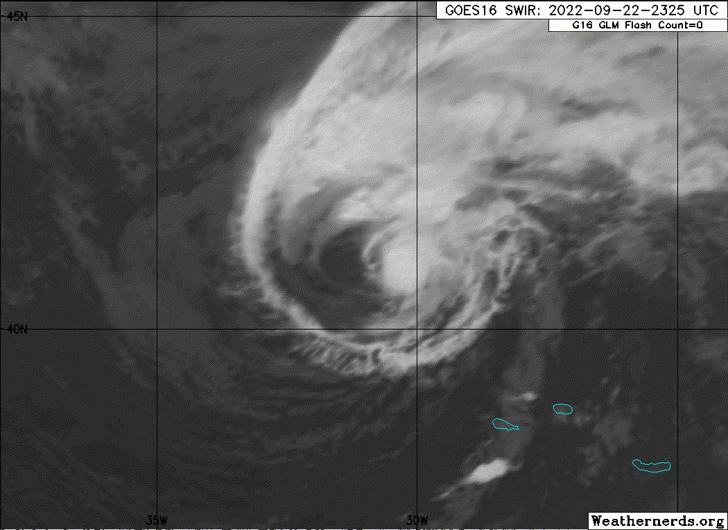
Gaston probably looks its best yet now. I'm a bit surprised they haven't gone a bit higher for intensity. I'm guessing 60 kt might be its final BT peak.
2 likes
-
Sciencerocks
- Category 5

- Posts: 10193
- Age: 40
- Joined: Thu Jul 06, 2017 1:51 am
-
CrazyC83
- Professional-Met
- Posts: 34316
- Joined: Tue Mar 07, 2006 11:57 pm
- Location: Deep South, for the first time!
Re: ATL: GASTON - Tropical Storm - Discussion
The last ASCAT pass still had 55 kt winds despite its decay in the last few hours. Cooler water taking its toll.
Could it have been a hurricane briefly at one point?
Could it have been a hurricane briefly at one point?
1 likes
-
HurricaneBelle

- S2K Supporter

- Posts: 1209
- Joined: Sun Aug 27, 2006 6:12 pm
- Location: Clearwater, FL
-
Sciencerocks
- Category 5
- Posts: 10193
- Age: 40
- Joined: Thu Jul 06, 2017 1:51 am


Re: ATL: GASTON - Tropical Storm - Discussion
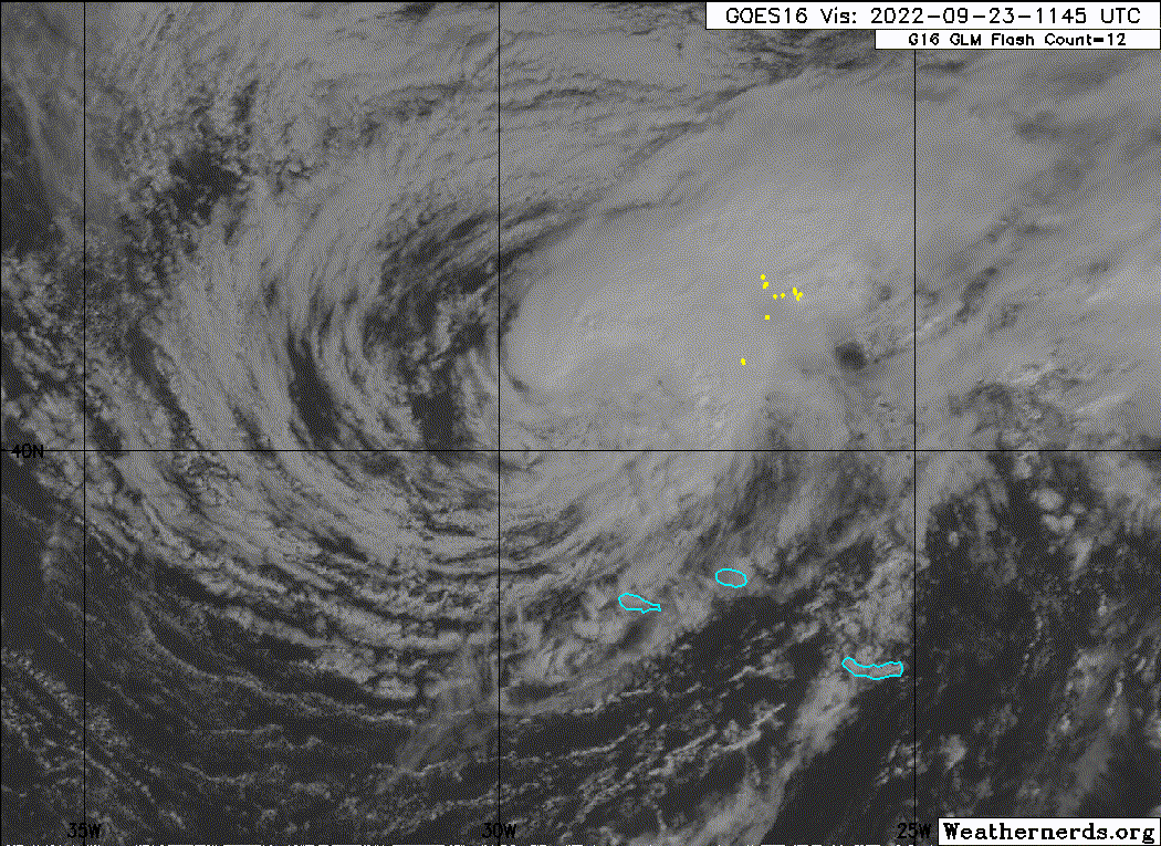
Is Gaston still trying to form an eye?

6 likes
TC naming lists: retirements and intensity
Most aggressive Advisory #1's in North Atlantic (cr. kevin for starting the list)
Most aggressive Advisory #1's in North Atlantic (cr. kevin for starting the list)
-
Iceresistance

- Category 5
- Posts: 9608
- Age: 22
- Joined: Sat Oct 10, 2020 9:45 am
- Location: Tecumseh, OK/Norman, OK
Re: ATL: GASTON - Tropical Storm - Discussion
Teban54 wrote:Is Gaston still trying to form an eye?
https://i.postimg.cc/g2Jk6RD1/image.png
Goodness! He's refusing to give in until he reaches Hurricane status!
3 likes
Bill 2015 & Beta 2020
Winter 2020-2021
All observations are in Tecumseh, OK unless otherwise noted.
Winter posts are focused mainly for Oklahoma & Texas.
Take any of my forecasts with a grain of salt, refer to the NWS, SPC, and NHC for official information
Never say Never with weather! Because ANYTHING is possible!
Winter 2020-2021
All observations are in Tecumseh, OK unless otherwise noted.
Winter posts are focused mainly for Oklahoma & Texas.
Take any of my forecasts with a grain of salt, refer to the NWS, SPC, and NHC for official information
Never say Never with weather! Because ANYTHING is possible!
-
Sciencerocks
- Category 5
- Posts: 10193
- Age: 40
- Joined: Thu Jul 06, 2017 1:51 am
-
tolakram
- Admin

- Posts: 20186
- Age: 62
- Joined: Sun Aug 27, 2006 8:23 pm
- Location: Florence, KY (name is Mark)
Re: ATL: GASTON - Tropical Storm - Discussion
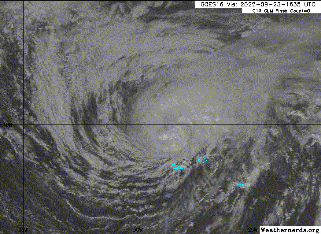
936
WTNT43 KNHC 231457
TCDAT3
Tropical Storm Gaston Discussion Number 13
NWS National Hurricane Center Miami FL AL082022
300 PM GMT Fri Sep 23 2022
Gaston is improving in satellite presentation this morning.
Convection is re-forming and wrapping around the northern and
western sides of the circulation. A recent scatterometer pass
showed that Gaston was slightly stronger than the previous advisory
and the initial intensity has been increased to 55 kt. The
tropical-storm-force wind field was also expanded, especially in the
northwestern quadrant based on these data.
The cyclone has managed to retain its tropical characteristics for
now. Global model guidance suggests moderate to strong vertical
wind shear should gradually strip away convection from the core over
the next day or so. In spite of the relatively hostile conditions,
Gaston has managed to maintain its strength, therefore only gradual
weakening is forecast until the storm merges with a shortwave trough
in about 36 hours and becomes a post-tropical cyclone. The official
intensity forecast has been shifted slightly higher than the
previous advisory due to the initial intensity and is slightly
stronger than the consensus model aids.
The storm is moving east-southeastward at an estimated 120/6 kt. A
sharp turn to the south is expected shortly while Gaston traverses
the periphery of a mid-level ridge building to the north.
Afterward, the cyclone should generally move toward the
west-southwest and west, completing an anticyclone turn, through the
end of the period. The NHC forecast has been nudged slightly
northward once again from the previous forecast and lies between the
HCCA and TVCN multi-model consensus aids.
Key Messages:
1. Tropical storm conditions are occurring over portions of the
western Azores, and are spreading to the central Azores.
2. Gaston is expected to produce heavy rainfall over the western
and central Azores today through Saturday. This rainfall may
result in landslides and areas of flooding.
FORECAST POSITIONS AND MAX WINDS
INIT 23/1500Z 40.2N 29.1W 55 KT 65 MPH
12H 24/0000Z 39.4N 29.0W 55 KT 65 MPH
24H 24/1200Z 38.7N 30.2W 50 KT 60 MPH
36H 25/0000Z 38.7N 32.3W 50 KT 60 MPH...POST-TROPICAL
48H 25/1200Z 38.9N 34.8W 50 KT 60 MPH...POST-TROPICAL
60H 26/0000Z 39.0N 36.7W 45 KT 50 MPH...POST-TROPICAL
72H 26/1200Z 39.0N 38.6W 40 KT 45 MPH...POST-TROPICAL
96H 27/1200Z 38.9N 42.0W 35 KT 40 MPH...POST-TROPICAL
120H 28/1200Z 37.7N 46.2W 30 KT 35 MPH...POST-TROPICAL
$$
Forecaster Bucci
0 likes
M a r k
- - - - -
Join us in chat: Storm2K Chatroom Invite. Android and IOS apps also available.
The posts in this forum are NOT official forecasts and should not be used as such. Posts are NOT endorsed by any professional institution or STORM2K.org. For official information and forecasts, please refer to NHC and NWS products.
-
galaxy401

- Category 5
- Posts: 2446
- Age: 30
- Joined: Sat Aug 25, 2012 9:04 pm
- Location: Casa Grande, Arizona
Re: ATL: GASTON - Tropical Storm - Discussion
Strange, I woke up expecting both Fiona and Gaston to be weaker and they both have strengthened back to their previous intensities. Persistent system.
1 likes
Got my eyes on moving right into Hurricane Alley: Florida.


Re: ATL: GASTON - Tropical Storm - Discussion
Not that I think it’ll get classified, and not that I have any evidence to suggest it other than the eye-test… but I personally think Gaston has at least been (briefly) a hurricane at some point over the past few days.
5 likes
-
tolakram
- Admin
- Posts: 20186
- Age: 62
- Joined: Sun Aug 27, 2006 8:23 pm
- Location: Florence, KY (name is Mark)
Re: ATL: GASTON - Tropical Storm - Discussion
I'm in the Hurricane Gaston camp.

14 likes
M a r k
- - - - -
Join us in chat: Storm2K Chatroom Invite. Android and IOS apps also available.
The posts in this forum are NOT official forecasts and should not be used as such. Posts are NOT endorsed by any professional institution or STORM2K.org. For official information and forecasts, please refer to NHC and NWS products.
- - - - -
Join us in chat: Storm2K Chatroom Invite. Android and IOS apps also available.
The posts in this forum are NOT official forecasts and should not be used as such. Posts are NOT endorsed by any professional institution or STORM2K.org. For official information and forecasts, please refer to NHC and NWS products.
Re: ATL: GASTON - Tropical Storm - Discussion
tolakram wrote:I'm in the Hurricane Gaston camp.
https://i.imgur.com/9yDQiAI.png
If so, we're very likely looking at five hurricanes this month, tied for the most in September during the active era back to 1995!
0 likes
Personal Forecast Disclaimer:
The posts in this forum are NOT official forecasts and should not be used as such. They are just the opinion of the poster and may or may not be backed by sound meteorological data. They are NOT endorsed by any professional institution or storm2k.org. For official information, please refer to the NHC and NWS products.
The posts in this forum are NOT official forecasts and should not be used as such. They are just the opinion of the poster and may or may not be backed by sound meteorological data. They are NOT endorsed by any professional institution or storm2k.org. For official information, please refer to the NHC and NWS products.
-
Sciencerocks
- Category 5
- Posts: 10193
- Age: 40
- Joined: Thu Jul 06, 2017 1:51 am
Re: ATL: GASTON - Tropical Storm - Discussion
I think this is probably a hurricane and looking at the data I also believe that it could be a tropical storm for another 4-5 days. 
0 likes
-
Sciencerocks
- Category 5
- Posts: 10193
- Age: 40
- Joined: Thu Jul 06, 2017 1:51 am
-
galaxy401
- Category 5
- Posts: 2446
- Age: 30
- Joined: Sat Aug 25, 2012 9:04 pm
- Location: Casa Grande, Arizona
Re: ATL: GASTON - Tropical Storm - Discussion
Azores might be a caught a little off guard with Gaston considering how persistent he has been maintaining its intensity. Still looks like a compact Tropical cyclone moving over those islands.
0 likes
Got my eyes on moving right into Hurricane Alley: Florida.
-
Sciencerocks
- Category 5
- Posts: 10193
- Age: 40
- Joined: Thu Jul 06, 2017 1:51 am


Re: ATL: GASTON - Tropical Storm - Discussion
us89 wrote:Bye bye convection…
Don't worry as it swings south east the convection might come back.
0 likes
-
Sciencerocks
- Category 5
- Posts: 10193
- Age: 40
- Joined: Thu Jul 06, 2017 1:51 am
Who is online
Users browsing this forum: No registered users and 44 guests