ATL: FIONA - Post-Tropical - Discussion
Moderator: S2k Moderators
-
Iceresistance

- Category 5

- Posts: 9592
- Age: 22
- Joined: Sat Oct 10, 2020 9:45 am
- Location: Tecumseh, OK/Norman, OK
Re: ATL: FIONA - Hurricane - Discussion
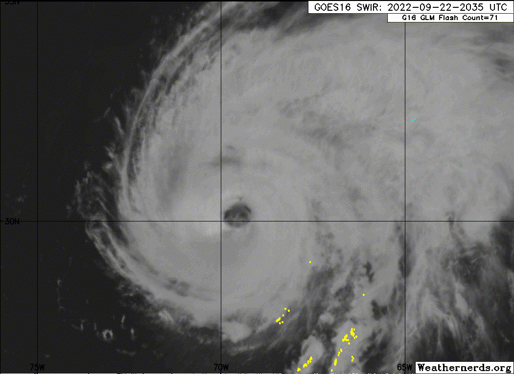
AF306 is not even close to the eyewall, but it has 65-knot SMFR and 981.4 mb Extrapolated pressure and Fiona has a somewhat strong pressure gradient.
0 likes
Bill 2015 & Beta 2020
Winter 2020-2021
All observations are in Tecumseh, OK unless otherwise noted.
Winter posts are focused mainly for Oklahoma & Texas.
Take any of my forecasts with a grain of salt, refer to the NWS, SPC, and NHC for official information
Never say Never with weather! Because ANYTHING is possible!
Winter 2020-2021
All observations are in Tecumseh, OK unless otherwise noted.
Winter posts are focused mainly for Oklahoma & Texas.
Take any of my forecasts with a grain of salt, refer to the NWS, SPC, and NHC for official information
Never say Never with weather! Because ANYTHING is possible!
-
Iceresistance
- Category 5
- Posts: 9592
- Age: 22
- Joined: Sat Oct 10, 2020 9:45 am
- Location: Tecumseh, OK/Norman, OK
Re: ATL: FIONA - Hurricane - Discussion
First pass: 930.6 mb Extrapolated
3 likes
Bill 2015 & Beta 2020
Winter 2020-2021
All observations are in Tecumseh, OK unless otherwise noted.
Winter posts are focused mainly for Oklahoma & Texas.
Take any of my forecasts with a grain of salt, refer to the NWS, SPC, and NHC for official information
Never say Never with weather! Because ANYTHING is possible!
Winter 2020-2021
All observations are in Tecumseh, OK unless otherwise noted.
Winter posts are focused mainly for Oklahoma & Texas.
Take any of my forecasts with a grain of salt, refer to the NWS, SPC, and NHC for official information
Never say Never with weather! Because ANYTHING is possible!

Re: ATL: FIONA - Hurricane - Discussion
The eye drop sucked. It’s completely unusable and doesn’t show anything below the 854mb level.
0 likes
Irene '11 Sandy '12 Hermine '16 5/15/2018 Derecho Fay '20 Isaias '20 Elsa '21 Henri '21 Ida '21
I am only a meteorology enthusiast who knows a decent amount about tropical cyclones. Look to the professional mets, the NHC, or your local weather office for the best information.
I am only a meteorology enthusiast who knows a decent amount about tropical cyclones. Look to the professional mets, the NHC, or your local weather office for the best information.
-
Iceresistance
- Category 5
- Posts: 9592
- Age: 22
- Joined: Sat Oct 10, 2020 9:45 am
- Location: Tecumseh, OK/Norman, OK
Re: ATL: FIONA - Hurricane - Discussion
aspen wrote:The eye drop sucked. It’s completely unusable and doesn’t show anything below the 854mb level.
The SW Eyewall drop does give us a good hint, the surface is at 936 mb with 61 knots of wind.
EDIT: There is also the VDM.
0 likes
Bill 2015 & Beta 2020
Winter 2020-2021
All observations are in Tecumseh, OK unless otherwise noted.
Winter posts are focused mainly for Oklahoma & Texas.
Take any of my forecasts with a grain of salt, refer to the NWS, SPC, and NHC for official information
Never say Never with weather! Because ANYTHING is possible!
Winter 2020-2021
All observations are in Tecumseh, OK unless otherwise noted.
Winter posts are focused mainly for Oklahoma & Texas.
Take any of my forecasts with a grain of salt, refer to the NWS, SPC, and NHC for official information
Never say Never with weather! Because ANYTHING is possible!
-
Sciencerocks
- Category 5
- Posts: 10186
- Age: 40
- Joined: Thu Jul 06, 2017 1:51 am
-
Iceresistance
- Category 5
- Posts: 9592
- Age: 22
- Joined: Sat Oct 10, 2020 9:45 am
- Location: Tecumseh, OK/Norman, OK
Re: ATL: FIONA - Hurricane - Discussion
Iceresistance wrote:aspen wrote:The eye drop sucked. It’s completely unusable and doesn’t show anything below the 854mb level.
The SW Eyewall drop does give us a good hint, the surface is at 936 mb with 61 knots of wind.
EDIT: There is also the VDM.
VDM shows 932 mb, Fiona is still deepening.
0 likes
Bill 2015 & Beta 2020
Winter 2020-2021
All observations are in Tecumseh, OK unless otherwise noted.
Winter posts are focused mainly for Oklahoma & Texas.
Take any of my forecasts with a grain of salt, refer to the NWS, SPC, and NHC for official information
Never say Never with weather! Because ANYTHING is possible!
Winter 2020-2021
All observations are in Tecumseh, OK unless otherwise noted.
Winter posts are focused mainly for Oklahoma & Texas.
Take any of my forecasts with a grain of salt, refer to the NWS, SPC, and NHC for official information
Never say Never with weather! Because ANYTHING is possible!
Re: ATL: FIONA - Hurricane - Discussion
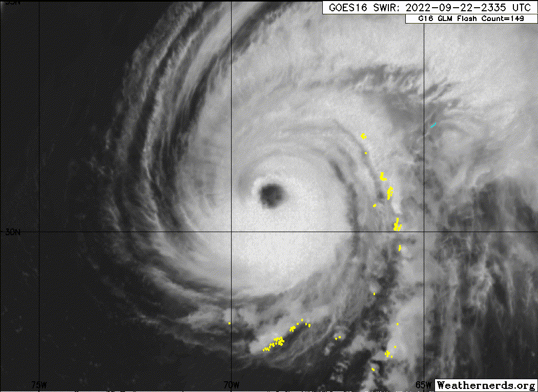
The extrapolated pressure is up this pass. I think Fiona peaked in the upper 920s earlier in the afternoon, around the 18z advisory. I’d go with 928-929/120 for an 18z BT revision based on the much clearer eye and smoother CDO, and the pressure rising a few mbar between these passes.
Also it seems like they’re going to avoid the SE quadrant, which has had the highest winds during the last few flights.
Also it seems like they’re going to avoid the SE quadrant, which has had the highest winds during the last few flights.
2 likes
Irene '11 Sandy '12 Hermine '16 5/15/2018 Derecho Fay '20 Isaias '20 Elsa '21 Henri '21 Ida '21
I am only a meteorology enthusiast who knows a decent amount about tropical cyclones. Look to the professional mets, the NHC, or your local weather office for the best information.
I am only a meteorology enthusiast who knows a decent amount about tropical cyclones. Look to the professional mets, the NHC, or your local weather office for the best information.
-
CrazyC83
- Professional-Met

- Posts: 34315
- Joined: Tue Mar 07, 2006 11:57 pm
- Location: Deep South, for the first time!
Re: ATL: FIONA - Hurricane - Discussion
I agree that it probably peaked at 18Z with 120 kt, since the current data supports 115 kt (given the sparse coverage). As far as pressure then, I would have also said 928 mb.
6 likes
-
HurricaneBelle

- S2K Supporter

- Posts: 1209
- Joined: Sun Aug 27, 2006 6:12 pm
- Location: Clearwater, FL
Re: ATL: FIONA - Hurricane - Discussion
As Fiona approaches Bermuda, here's a great page with automatically-updated observations on the island:
http://weather.bm/tools/graphics.asp?na ... AWOS&user=
Right now stations are reporting winds in the 40-50 kt range.
http://weather.bm/tools/graphics.asp?na ... AWOS&user=
Right now stations are reporting winds in the 40-50 kt range.
1 likes

Re: ATL: FIONA - Hurricane - Discussion
A shame the Bermuda radar is down right now.
0 likes
Igor 2010, Sandy 2012, Fay 2014, Gonzalo 2014, Joaquin 2015, Nicole 2016, Humberto 2019, Imelda 2025
I am only a tropical weather enthusiast. My predictions are not official and may or may not be backed by sound meteorological data. For official information, please refer to the NHC and NWS products.
I am only a tropical weather enthusiast. My predictions are not official and may or may not be backed by sound meteorological data. For official information, please refer to the NHC and NWS products.
-
Sciencerocks
- Category 5
- Posts: 10186
- Age: 40
- Joined: Thu Jul 06, 2017 1:51 am
-
galaxy401

- Category 5
- Posts: 2446
- Age: 30
- Joined: Sat Aug 25, 2012 9:04 pm
- Location: Casa Grande, Arizona
Re: ATL: FIONA - Hurricane - Discussion
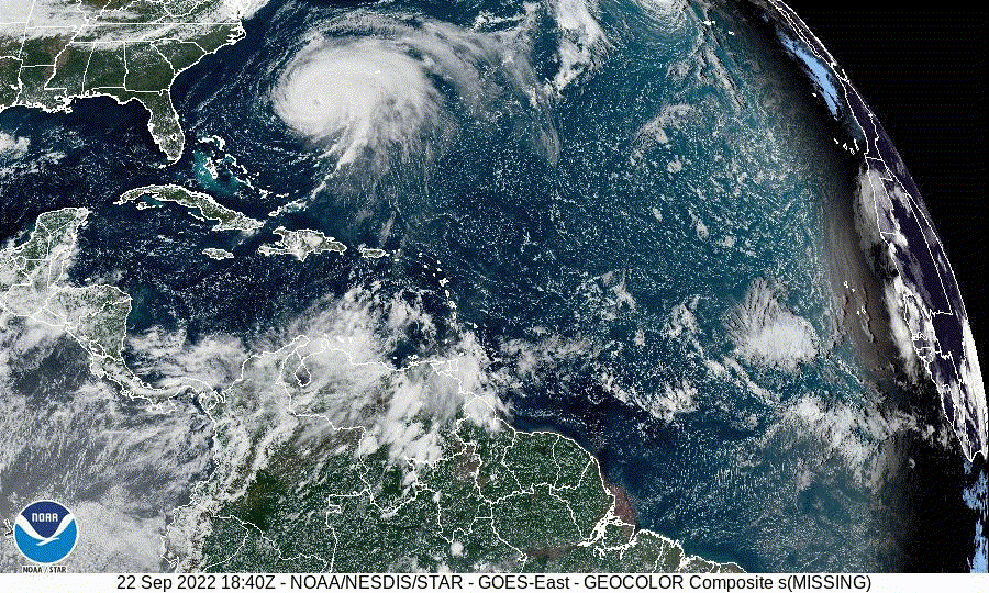
NHC showing Cat 2 intensity at landfall on Nova Scotia. This could rival Juan in intensity, but the issue is that Fiona is much bigger.
0 likes
Got my eyes on moving right into Hurricane Alley: Florida.
-
CrazyC83
- Professional-Met
- Posts: 34315
- Joined: Tue Mar 07, 2006 11:57 pm
- Location: Deep South, for the first time!
Re: ATL: FIONA - Hurricane - Discussion
HurricaneBelle wrote:As Fiona approaches Bermuda, here's a great page with automatically-updated observations on the island:
http://weather.bm/tools/graphics.asp?na ... AWOS&user=
Right now stations are reporting winds in the 40-50 kt range.
Many of the stations are elevated so they aren't representative of Fiona's true intensity, but they are representative of the locations where many people live.
0 likes
-
CrazyC83
- Professional-Met
- Posts: 34315
- Joined: Tue Mar 07, 2006 11:57 pm
- Location: Deep South, for the first time!
Re: ATL: FIONA - Hurricane - Discussion
galaxy401 wrote:NHC showing Cat 2 intensity at landfall on Nova Scotia. This could rival Juan in intensity, but the issue is that Fiona is much bigger.
The storm surge and waves will far exceed Juan since the size will be many orders of magnitude larger. That is always a poor comparison, since Juan was unique for Nova Scotia in that it was a very tropical system and concentrated its impacts in a modest area (i.e., the Halifax metro and northward) with a solid eye and eyewall.
2 likes
-
InfernoFlameCat

- Category 5
- Posts: 2127
- Age: 22
- Joined: Mon Dec 14, 2020 10:52 am
- Location: Buford, GA
Re: ATL: FIONA - Hurricane - Discussion
Fiona is one huge hurricane. It might get larger than even sandy.
2 likes
I am by no means a professional. DO NOT look at my forecasts for official information or make decisions based on what I post.
Goal: to become a registered expert over tropical and subtropical cyclones.
Goal: to become a registered expert over tropical and subtropical cyclones.
-
Sciencerocks
- Category 5
- Posts: 10186
- Age: 40
- Joined: Thu Jul 06, 2017 1:51 am
-
Hybridstorm_November2001

- S2K Supporter
- Posts: 2817
- Joined: Sat Aug 21, 2004 2:50 pm
- Location: SW New Brunswick, Canada
- Contact:
Re: ATL: FIONA - Hurricane - Discussion
CrazyC83 wrote:galaxy401 wrote:NHC showing Cat 2 intensity at landfall on Nova Scotia. This could rival Juan in intensity, but the issue is that Fiona is much bigger.
The storm surge and waves will far exceed Juan since the size will be many orders of magnitude larger. That is always a poor comparison, since Juan was unique for Nova Scotia in that it was a very tropical system and concentrated its impacts in a modest area (i.e., the Halifax metro and northward) with a solid eye and eyewall.
This is true. Outside of Central Nova Scotia and (to a much lesser extent) Prince Edward Island, Juan barely had any impact on the rest of the region due to its Andrew-like size.
0 likes

Re: ATL: FIONA - Hurricane - Discussion
Holding steady.
0 likes
Personal Forecast Disclaimer:
The posts in this forum are NOT official forecast and should not be used as such. They are just the opinion of the poster and may or may not be backed by sound meteorological data. For official information, please refer to the NHC and NWS products.
The posts in this forum are NOT official forecast and should not be used as such. They are just the opinion of the poster and may or may not be backed by sound meteorological data. For official information, please refer to the NHC and NWS products.

Re: ATL: FIONA - Hurricane - Discussion
Hybridstorm_November2001 wrote:CrazyC83 wrote:galaxy401 wrote:NHC showing Cat 2 intensity at landfall on Nova Scotia. This could rival Juan in intensity, but the issue is that Fiona is much bigger.
The storm surge and waves will far exceed Juan since the size will be many orders of magnitude larger. That is always a poor comparison, since Juan was unique for Nova Scotia in that it was a very tropical system and concentrated its impacts in a modest area (i.e., the Halifax metro and northward) with a solid eye and eyewall.
This is true. Outside of Central Nova Scotia and (to a much lesser extent) Prince Edward Island, Juan barely had any impact on the rest of the region due to its Andrew-like size.
The good news is at least it will likely come ashore somewhat east of Halifax , sparing it some. A place like Louisbourg though is gonna have a rough day.
0 likes
Re: ATL: FIONA - Hurricane - Discussion
Prince Edward's Island will have the roughest day, relatively speaking.
0 likes
Who is online
Users browsing this forum: No registered users and 33 guests