ATL: IAN - Models
Moderator: S2k Moderators

Re: ATL: NINE - Models
The 12z icon Has the storm parked right after it gets through Florida until the end of its runs. GFS did something similar where it took the remnants of the storm and brought it back into Florida and then into the gulf. What are these models catching on to.
0 likes
-
skyline385

- Category 5

- Posts: 2728
- Age: 35
- Joined: Wed Aug 26, 2020 11:15 pm
- Location: Houston TX
Re: ATL: NINE - Models
caneseddy wrote:skyline385 wrote:ICON 12Z
https://uploads.tapatalk-cdn.com/20220923/1622c68e2c34ef1e6cbfd42ad3a76b7b.jpg
Sent from my iPhone using Tapatalk
Looks like Naples landfall or just south of it as a major hurricane. SE Florida gets dirty side
Here’s zoomed in view


Sent from my iPhone using Tapatalk
0 likes
Re: ATL: NINE - Models
skyline385 wrote:caneseddy wrote:skyline385 wrote:ICON 12Z
https://uploads.tapatalk-cdn.com/20220923/1622c68e2c34ef1e6cbfd42ad3a76b7b.jpg
Sent from my iPhone using Tapatalk
Looks like Naples landfall or just south of it as a major hurricane. SE Florida gets dirty side
Here’s zoomed in view
https://uploads.tapatalk-cdn.com/20220923/bc46c29e6918b1f41c2d5f0cc31f7ec4.jpg
https://uploads.tapatalk-cdn.com/20220923/3f18a84301f44342c50b183d281d6750.jpg
Sent from my iPhone using Tapatalk
Wilma Part 2. ICON and Euro very consistent with a landfall further south than all other models.
1 likes
-
tolakram
- Admin

- Posts: 20186
- Age: 62
- Joined: Sun Aug 27, 2006 8:23 pm
- Location: Florence, KY (name is Mark)
Re: ATL: NINE - Models
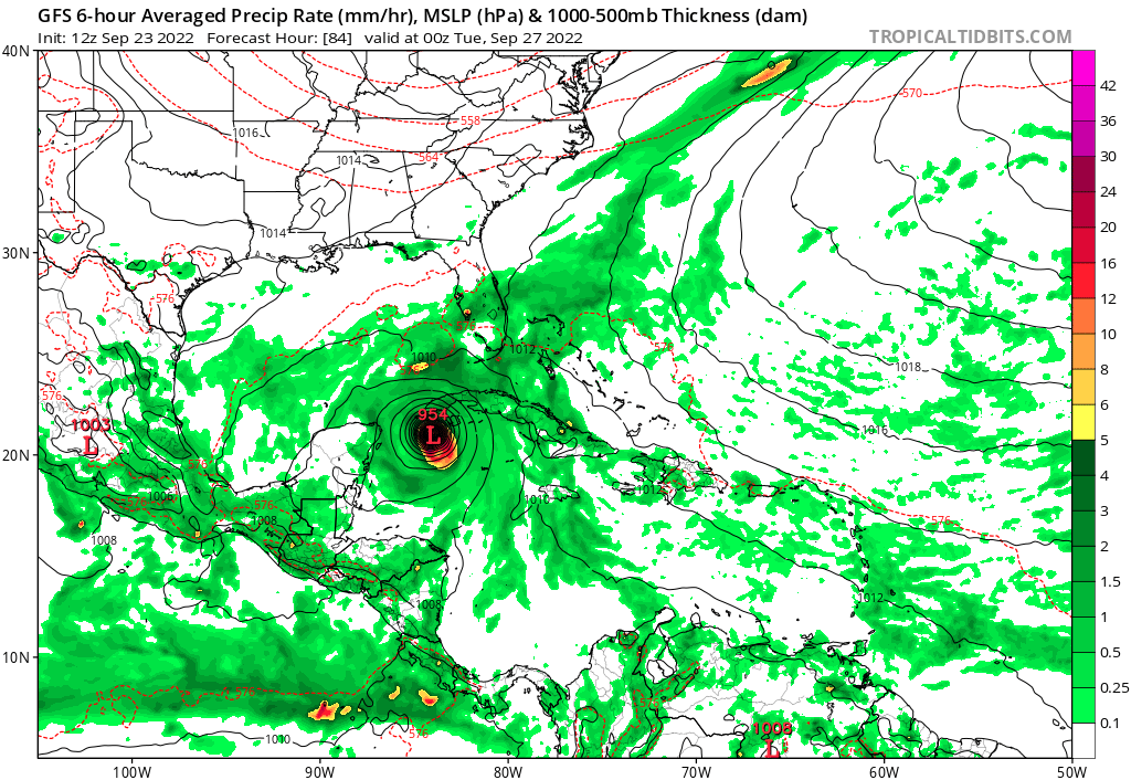
12Z GFS running

0 likes
M a r k
- - - - -
Join us in chat: Storm2K Chatroom Invite. Android and IOS apps also available.
The posts in this forum are NOT official forecasts and should not be used as such. Posts are NOT endorsed by any professional institution or STORM2K.org. For official information and forecasts, please refer to NHC and NWS products.

Re: ATL: NINE - Models
Fancy1001 wrote:The 12z icon Has the storm parked right after it gets through Florida until the end of its runs. GFS did something similar where it took the remnants of the storm and brought it back into Florida and then into the gulf. What are these models catching on to.
Yes, it's really unusual I can't remember seeing such a path before. TD9 stays above/next to Florida for more than 60 hours this run and even strenghtens again back to the low 950s at +165. After 30 hours some parts along the east coast of Florida already show 24+ inches of rain in the ICON run. The amount of rain this would result in... it's almost like it's trying to create a Harvey for Florida. Let's hope the other models don't trend the same way.
Last edited by kevin on Fri Sep 23, 2022 10:51 am, edited 1 time in total.
1 likes
-
cheezyWXguy

- Category 5
- Posts: 6282
- Joined: Mon Feb 13, 2006 12:29 am
- Location: Dallas, TX
Re: ATL: NINE - Models
tolakram wrote:12Z GFS running
https://i.imgur.com/nTjJSdy.gif
Looks a lot less…irregular…in its development this run
1 likes
-
tolakram
- Admin
- Posts: 20186
- Age: 62
- Joined: Sun Aug 27, 2006 8:23 pm
- Location: Florence, KY (name is Mark)
Re: ATL: NINE - Models

0 likes
M a r k
- - - - -
Join us in chat: Storm2K Chatroom Invite. Android and IOS apps also available.
The posts in this forum are NOT official forecasts and should not be used as such. Posts are NOT endorsed by any professional institution or STORM2K.org. For official information and forecasts, please refer to NHC and NWS products.
- - - - -
Join us in chat: Storm2K Chatroom Invite. Android and IOS apps also available.
The posts in this forum are NOT official forecasts and should not be used as such. Posts are NOT endorsed by any professional institution or STORM2K.org. For official information and forecasts, please refer to NHC and NWS products.
-
skyline385
- Category 5
- Posts: 2728
- Age: 35
- Joined: Wed Aug 26, 2020 11:15 pm
- Location: Houston TX
ATL: NINE - Models
ICON also stalls it just offshore of WPB similar to last nights runs, i think a stall inland would be pretty devastating
Sent from my iPhone using Tapatalk
Sent from my iPhone using Tapatalk
0 likes
-
Miami Storm Tracker

- Category 4

- Posts: 916
- Age: 68
- Joined: Sun Jun 13, 2010 10:12 pm
- Location: Key Largo, Fla.
- Contact:
Re: ATL: NINE - Models
Afternoon everyone,
Been busy at work playing catch up here. Not liking the Icon run at all, if this does become the the point of land fall what kind of storm surge are we looking at in the upper keys. I would think a fairly descent amount with the counter clock wise flow, any Pro's care to provide an estimates? Would be much appreciated.
Been busy at work playing catch up here. Not liking the Icon run at all, if this does become the the point of land fall what kind of storm surge are we looking at in the upper keys. I would think a fairly descent amount with the counter clock wise flow, any Pro's care to provide an estimates? Would be much appreciated.
0 likes
-
tolakram
- Admin
- Posts: 20186
- Age: 62
- Joined: Sun Aug 27, 2006 8:23 pm
- Location: Florence, KY (name is Mark)
Re: ATL: NINE - Models

1 likes
M a r k
- - - - -
Join us in chat: Storm2K Chatroom Invite. Android and IOS apps also available.
The posts in this forum are NOT official forecasts and should not be used as such. Posts are NOT endorsed by any professional institution or STORM2K.org. For official information and forecasts, please refer to NHC and NWS products.
- - - - -
Join us in chat: Storm2K Chatroom Invite. Android and IOS apps also available.
The posts in this forum are NOT official forecasts and should not be used as such. Posts are NOT endorsed by any professional institution or STORM2K.org. For official information and forecasts, please refer to NHC and NWS products.
-
p1nheadlarry

- Category 2

- Posts: 672
- Age: 34
- Joined: Wed Jan 29, 2014 2:42 pm
- Location: SR County FL
Re: ATL: NINE - Models
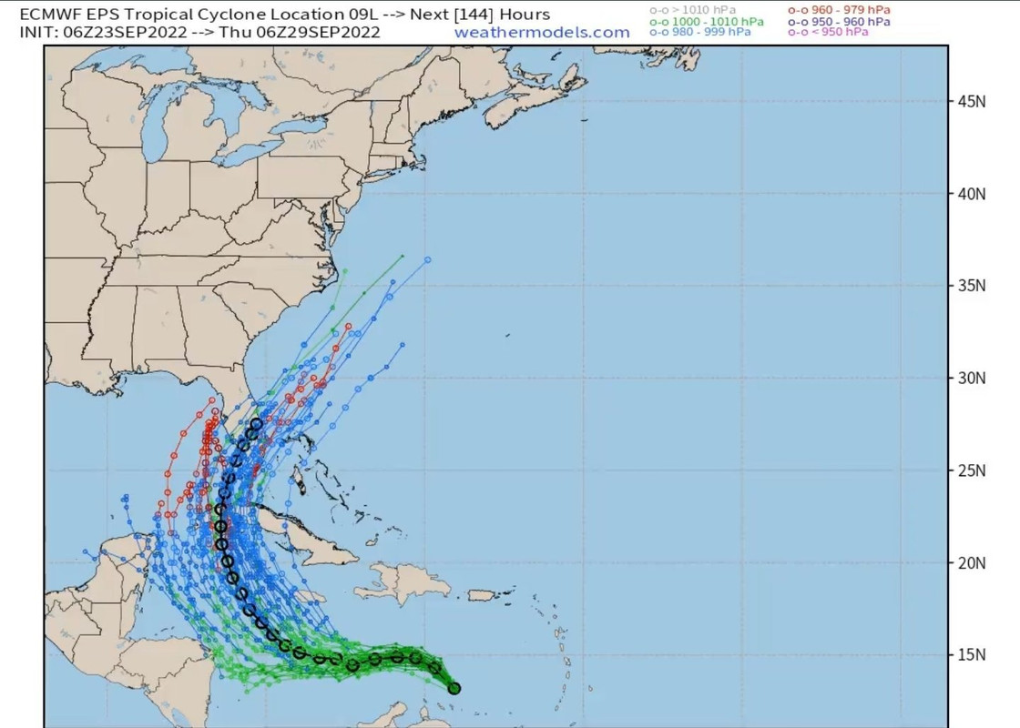
stpetenailbiter wrote:SFLcane wrote:skyline385 wrote:06Z EPS zoomed in, there seems to be a group which goes through SFL and a group (from center relocation maybe) which is westwards.
https://uploads.tapatalk-cdn.com/20220923/91f69f92d33818a0a1458b665c8e8b66.jpg
Sent from my iPhone using Tapatalk
There is has not been any center relocation that i am aware off its some eddys rotating around the broader llc. But either way the mean in black is still across South Florida. We wait and watch
https://i.postimg.cc/Pr6rPPY3/epshh.jpg
I'm curious what effect the trough will have on shearing the system if it does follow some of the westernmost ensemble members. But those westernmost ensemble members are the strongest of any on the run. NHC mentions intensity likely capping as it approaches shore in their latest discussion. Can any mets lurking explain the disparity between the discussion and those Euro members bombing out?
Long time lurker, first time poster.
The storm is going to be pulling in some drier air as this cold front moves across the region and also won't be in a configuration where the jet interacts favorably with it (read as: shear). In addition the eastern gulf tends to be cooler off the shelf. Probably your main limiting factors as landfall approaches.
- degreed met but not operational/research (basically just a SW engineer lol)
1 likes
--;->#GoNoles--;->.
-
gatorcane

- S2K Supporter

- Posts: 23708
- Age: 48
- Joined: Sun Mar 13, 2005 3:54 pm
- Location: Boca Raton, FL
Re: ATL: NINE - Models
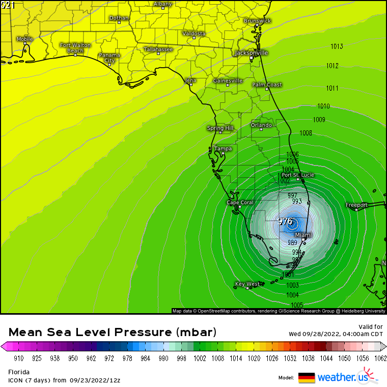
The GFS has the same location on 12Z at 78 hours as 06Z and 4 mb weaker.
Last edited by gatorcane on Fri Sep 23, 2022 10:56 am, edited 1 time in total.
0 likes
-
skyline385
- Category 5
- Posts: 2728
- Age: 35
- Joined: Wed Aug 26, 2020 11:15 pm
- Location: Houston TX
ATL: NINE - Models
Decently strong westward 12Z GFS

Sent from my iPhone using Tapatalk
Sent from my iPhone using Tapatalk
Last edited by skyline385 on Fri Sep 23, 2022 10:56 am, edited 1 time in total.
0 likes
-
tolakram
- Admin
- Posts: 20186
- Age: 62
- Joined: Sun Aug 27, 2006 8:23 pm
- Location: Florence, KY (name is Mark)
Re: ATL: NINE - Models
I'll be posting the MSLP maps but keep in mind global intensity estimates just aren't that great.

3 likes
M a r k
- - - - -
Join us in chat: Storm2K Chatroom Invite. Android and IOS apps also available.
The posts in this forum are NOT official forecasts and should not be used as such. Posts are NOT endorsed by any professional institution or STORM2K.org. For official information and forecasts, please refer to NHC and NWS products.
- - - - -
Join us in chat: Storm2K Chatroom Invite. Android and IOS apps also available.
The posts in this forum are NOT official forecasts and should not be used as such. Posts are NOT endorsed by any professional institution or STORM2K.org. For official information and forecasts, please refer to NHC and NWS products.
-
AutoPenalti
- Category 5
- Posts: 4091
- Age: 29
- Joined: Mon Aug 17, 2015 4:16 pm
- Location: Ft. Lauderdale, Florida
Re: ATL: NINE - Models
Probably back to Tallahassee this run?
0 likes
The posts in this forum are NOT official forecasts and should not be used as such. They are just the opinion of the poster and may or may not be backed by sound meteorological data. They are NOT endorsed by any professional institution or STORM2K. For official information, please refer to products from the NHC and NWS.
Model Runs Cheat Sheet:
GFS (5:30 AM/PM, 11:30 AM/PM)
HWRF, GFDL, UKMET, NAVGEM (6:30-8:00 AM/PM, 12:30-2:00 AM/PM)
ECMWF (1:45 AM/PM)
TCVN is a weighted averaged
-
tolakram
- Admin
- Posts: 20186
- Age: 62
- Joined: Sun Aug 27, 2006 8:23 pm
- Location: Florence, KY (name is Mark)
Re: ATL: NINE - Models
5 run GFS trend

1 likes
M a r k
- - - - -
Join us in chat: Storm2K Chatroom Invite. Android and IOS apps also available.
The posts in this forum are NOT official forecasts and should not be used as such. Posts are NOT endorsed by any professional institution or STORM2K.org. For official information and forecasts, please refer to NHC and NWS products.
- - - - -
Join us in chat: Storm2K Chatroom Invite. Android and IOS apps also available.
The posts in this forum are NOT official forecasts and should not be used as such. Posts are NOT endorsed by any professional institution or STORM2K.org. For official information and forecasts, please refer to NHC and NWS products.
-
TheHurricaneGod
- Tropical Storm

- Posts: 165
- Age: 23
- Joined: Thu Apr 16, 2020 6:19 pm
- Location: Fort Lauderdale
Re: ATL: NINE - Models
Slightly stronger EC trough at hr 84. Storm is a little further south. That's three runs in a row where it shifted south (at that particular time).
0 likes
-
tolakram
- Admin
- Posts: 20186
- Age: 62
- Joined: Sun Aug 27, 2006 8:23 pm
- Location: Florence, KY (name is Mark)
Re: ATL: NINE - Models

1 likes
M a r k
- - - - -
Join us in chat: Storm2K Chatroom Invite. Android and IOS apps also available.
The posts in this forum are NOT official forecasts and should not be used as such. Posts are NOT endorsed by any professional institution or STORM2K.org. For official information and forecasts, please refer to NHC and NWS products.
- - - - -
Join us in chat: Storm2K Chatroom Invite. Android and IOS apps also available.
The posts in this forum are NOT official forecasts and should not be used as such. Posts are NOT endorsed by any professional institution or STORM2K.org. For official information and forecasts, please refer to NHC and NWS products.
Who is online
Users browsing this forum: No registered users and 9 guests