ATL: IAN - Models
Moderator: S2k Moderators

-
chris_fit

- Category 5

- Posts: 3261
- Age: 43
- Joined: Wed Sep 10, 2003 11:58 pm
- Location: Tampa Bay Area, FL
Re: ATL: NINE - Models
AutoPenalti wrote:Literally a 60 mile difference.
True. But major impacts also completely different metropolises.
0 likes
-
AutoPenalti
- Category 5
- Posts: 4091
- Age: 29
- Joined: Mon Aug 17, 2015 4:16 pm
- Location: Ft. Lauderdale, Florida
Re: ATL: NINE - Models
Damn well, it's the GFS vs Euro now...
0 likes
The posts in this forum are NOT official forecasts and should not be used as such. They are just the opinion of the poster and may or may not be backed by sound meteorological data. They are NOT endorsed by any professional institution or STORM2K. For official information, please refer to products from the NHC and NWS.
Model Runs Cheat Sheet:
GFS (5:30 AM/PM, 11:30 AM/PM)
HWRF, GFDL, UKMET, NAVGEM (6:30-8:00 AM/PM, 12:30-2:00 AM/PM)
ECMWF (1:45 AM/PM)
TCVN is a weighted averaged
-
Iceresistance

- Category 5
- Posts: 9592
- Age: 22
- Joined: Sat Oct 10, 2020 9:45 am
- Location: Tecumseh, OK/Norman, OK
Re: ATL: NINE - Models

0 likes
Bill 2015 & Beta 2020
Winter 2020-2021
All observations are in Tecumseh, OK unless otherwise noted.
Winter posts are focused mainly for Oklahoma & Texas.
Take any of my forecasts with a grain of salt, refer to the NWS, SPC, and NHC for official information
Never say Never with weather! Because ANYTHING is possible!
Winter 2020-2021
All observations are in Tecumseh, OK unless otherwise noted.
Winter posts are focused mainly for Oklahoma & Texas.
Take any of my forecasts with a grain of salt, refer to the NWS, SPC, and NHC for official information
Never say Never with weather! Because ANYTHING is possible!
-
chris_fit
- Category 5
- Posts: 3261
- Age: 43
- Joined: Wed Sep 10, 2003 11:58 pm
- Location: Tampa Bay Area, FL
Re: ATL: NINE - Models
Exits around space coast - don't see a stall like some of the other models.

0 likes
-
tolakram
- Admin

- Posts: 20186
- Age: 62
- Joined: Sun Aug 27, 2006 8:23 pm
- Location: Florence, KY (name is Mark)
Re: ATL: NINE - Models
12Z HWRF

1 likes
M a r k
- - - - -
Join us in chat: Storm2K Chatroom Invite. Android and IOS apps also available.
The posts in this forum are NOT official forecasts and should not be used as such. Posts are NOT endorsed by any professional institution or STORM2K.org. For official information and forecasts, please refer to NHC and NWS products.


-
ColdMiser123

- Professional-Met

- Posts: 905
- Age: 29
- Joined: Mon Sep 26, 2016 3:26 pm
- Location: Northeast US
Re: ATL: NINE - Models
2nd landfall on the Euro near the SC/NC border in about a week, as a ridge builds to the northeast preventing an escape from the rest of the US.
0 likes
B.S., M.S., Meteorology & Atmospheric Science
Re: ATL: NINE - Models
Euro landfall 168 SC/NC border.
0 likes
Personal Forecast Disclaimer:
The posts in this forum are NOT official forecasts and should not be used as such. They are just the opinion of the poster and may or may not be backed by sound meteorological data. They are NOT endorsed by any professional institution or storm2k.org. For official information, please refer to the NHC and NWS products.
The posts in this forum are NOT official forecasts and should not be used as such. They are just the opinion of the poster and may or may not be backed by sound meteorological data. They are NOT endorsed by any professional institution or storm2k.org. For official information, please refer to the NHC and NWS products.


Re: ATL: NINE - Models
Both the 12Z GFS and Euro have a 1033 MB high centered over Wisconsin.
Trough is outlined by 1014 and 1016 mb lines off the east coast at ~120 hours very similar except GFS has a smidge stronger ridging to the east.
But bigger difference between 00z and !2Z Euro as that 1014 line is bulging further west.
Not sure I would change the official track yet unless the trend continues west.
1 likes

-
jlauderdal
- S2K Supporter

- Posts: 7240
- Joined: Wed May 19, 2004 5:46 am
- Location: NE Fort Lauderdale
- Contact:
Re: ATL: NINE - Models
Right, the GFS has been known to run right through fronts, discount it
0 likes
-
ConvergenceZone
.gif)
- Category 5
- Posts: 5241
- Joined: Fri Jul 29, 2005 1:40 am
- Location: Northern California
Re: ATL: NINE - Models
I know that strength is off many times when it comes to models, but what Cat is the EURO now forecasting upon a Florida Landfall? I can never tell by the numbers...
0 likes
-
skyline385

- Category 5
- Posts: 2728
- Age: 35
- Joined: Wed Aug 26, 2020 11:15 pm
- Location: Houston TX
Re: ATL: NINE - Models
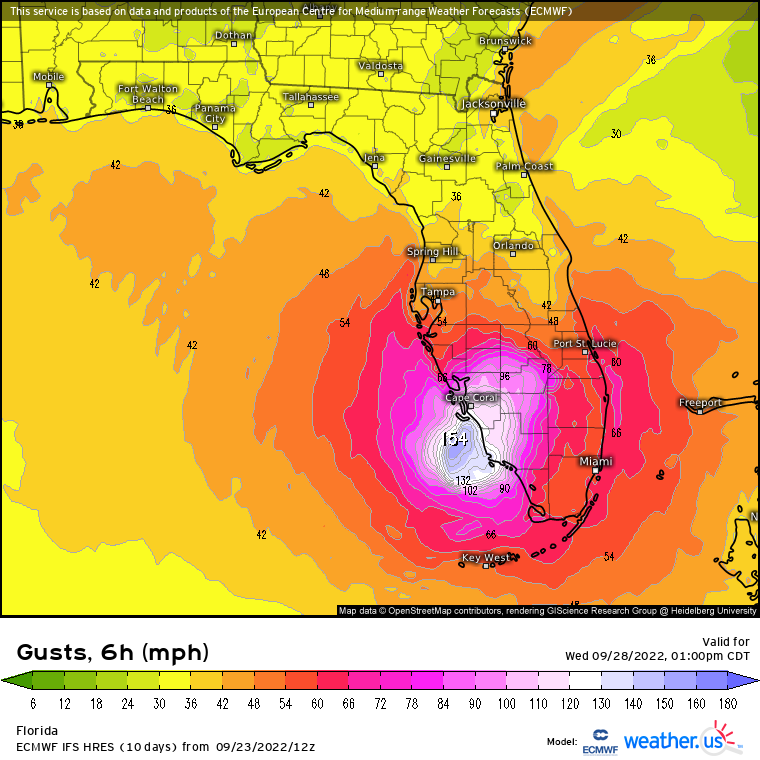
Precipitation plot from 12Z Euro, looks like a small core

Sent from my iPhone using Tapatalk
Sent from my iPhone using Tapatalk
0 likes
-
Iceresistance
- Category 5
- Posts: 9592
- Age: 22
- Joined: Sat Oct 10, 2020 9:45 am
- Location: Tecumseh, OK/Norman, OK
Re: ATL: NINE - Models
ConvergenceZone wrote:I know that strength is off many times when it comes to models, but what Cat is the EURO now forecasting upon a Florida Landfall? I can never tell by the numbers...
A 2/3 based on the pressure levels, there is no 10 meter wind option on TT.
0 likes
Bill 2015 & Beta 2020
Winter 2020-2021
All observations are in Tecumseh, OK unless otherwise noted.
Winter posts are focused mainly for Oklahoma & Texas.
Take any of my forecasts with a grain of salt, refer to the NWS, SPC, and NHC for official information
Never say Never with weather! Because ANYTHING is possible!
Winter 2020-2021
All observations are in Tecumseh, OK unless otherwise noted.
Winter posts are focused mainly for Oklahoma & Texas.
Take any of my forecasts with a grain of salt, refer to the NWS, SPC, and NHC for official information
Never say Never with weather! Because ANYTHING is possible!
Re: ATL: NINE - Models
ConvergenceZone wrote:I know that strength is off many times when it comes to models, but what Cat is the EURO now forecasting upon a Florida Landfall? I can never tell by the numbers...
Based on typical pressures 949 at landfall, so usual for a higher end category 3. Pushing 4. The scale is windspeed, so it's based on "typical" pressures for the category.
Last edited by BobHarlem on Fri Sep 23, 2022 1:52 pm, edited 2 times in total.
2 likes
Who is online
Users browsing this forum: No registered users and 35 guests