ATL: IAN - Post-Tropical - Discussion

Moderator: S2k Moderators

Message
Author
AutoPenalti
Category 5
Category 5
Posts: 4030
Age: 29
Joined: Mon Aug 17, 2015 4:16 pm
Location: Ft. Lauderdale, Florida

Re: ATL: NINE - Tropical Depression - Discussion

#701 Postby AutoPenalti » Fri Sep 23, 2022 3:44 pm

skyline385 wrote:
AutoPenalti wrote:My eyes are strained but is that another vort inside that convection?

You got good eyes

https://twitter.com/tropicaltidbits/status/1573408054158458881?s=46&t=C8uigb4BbdevymdzFgrW9g


Sent from my iPhone using Tapatalk

Yeah it looks anti-cyclonic...
0 likes   
The posts in this forum are NOT official forecasts and should not be used as such. They are just the opinion of the poster and may or may not be backed by sound meteorological data. They are NOT endorsed by any professional institution or STORM2K. For official information, please refer to products from the NHC and NWS.


Model Runs Cheat Sheet:
GFS (5:30 AM/PM, 11:30 AM/PM)
HWRF, GFDL, UKMET, NAVGEM (6:30-8:00 AM/PM, 12:30-2:00 AM/PM)
ECMWF (1:45 AM/PM)

TCVN
is a weighted averaged

Sanibel
Category 5
Category 5
Posts: 10375
Joined: Mon Aug 30, 2004 11:06 pm
Location: Offshore SW Florida

Re: ATL: NINE - Tropical Depression - Discussion

#702 Postby Sanibel » Fri Sep 23, 2022 3:46 pm

Gary543 wrote:
ObsessedMiami wrote:
SFLcane wrote:
People in SFL dont even know what is heading this way and most to even prepare anymore.


My nephew who works at Walmart on Bird Road in Miami says the water is starting to fly out the door. Just wait until the 5pm SFL News cycle to start. Get your gas tonight


Costco in North Palm Beach was a madhouse at lunch; both inside the store and the lines for gas.


The gas station on Sanibel was like a normal day and I filled-up no problem...
1 likes   

MJGarrison
Tropical Storm
Tropical Storm
Posts: 146
Joined: Wed Aug 30, 2017 7:26 pm

Re: ATL: NINE - Tropical Depression - Discussion

#703 Postby MJGarrison » Fri Sep 23, 2022 3:46 pm

AutoPenalti wrote:
skyline385 wrote:
AutoPenalti wrote:My eyes are strained but is that another vort inside that convection?

You got good eyes

https://twitter.com/tropicaltidbits/status/1573408054158458881?s=46&t=C8uigb4BbdevymdzFgrW9g


Sent from my iPhone using Tapatalk

Yeah it looks anti-cyclonic...

I’m no expert, but if you look at the meso sector, 1 minute images, it just looks like the shear has lessened and the cloud tops are expanding in all directions. I admit the normal 15 minute images do appear anti-cyclonic.


Sent from my iPad using Tapatalk
0 likes   

arlwx
Category 1
Category 1
Posts: 294
Joined: Fri Dec 05, 2003 5:38 am

Re: ATL: NINE - Tropical Depression - Discussion

#704 Postby arlwx » Fri Sep 23, 2022 3:55 pm

Still Nine for now.

Tropical Depression Nine Advisory Number 3
NWS National Hurricane Center Miami FL AL092022
500 PM EDT Fri Sep 23 2022

...HURRICANE WATCH ISSUED FOR THE CAYMAN ISLANDS AND TROPICAL STORM
WATCH ISSUED FOR JAMAICA...
...AIR FORCE HURRICANE HUNTERS EN ROUTE TO INVESTIGATE THE
DEPRESSION...
0 likes   

User avatar
aspen
Category 5
Category 5
Posts: 8818
Joined: Sat Oct 12, 2019 7:10 pm
Location: Connecticut, USA

Re: ATL: NINE - Tropical Depression - Discussion

#705 Postby aspen » Fri Sep 23, 2022 3:56 pm

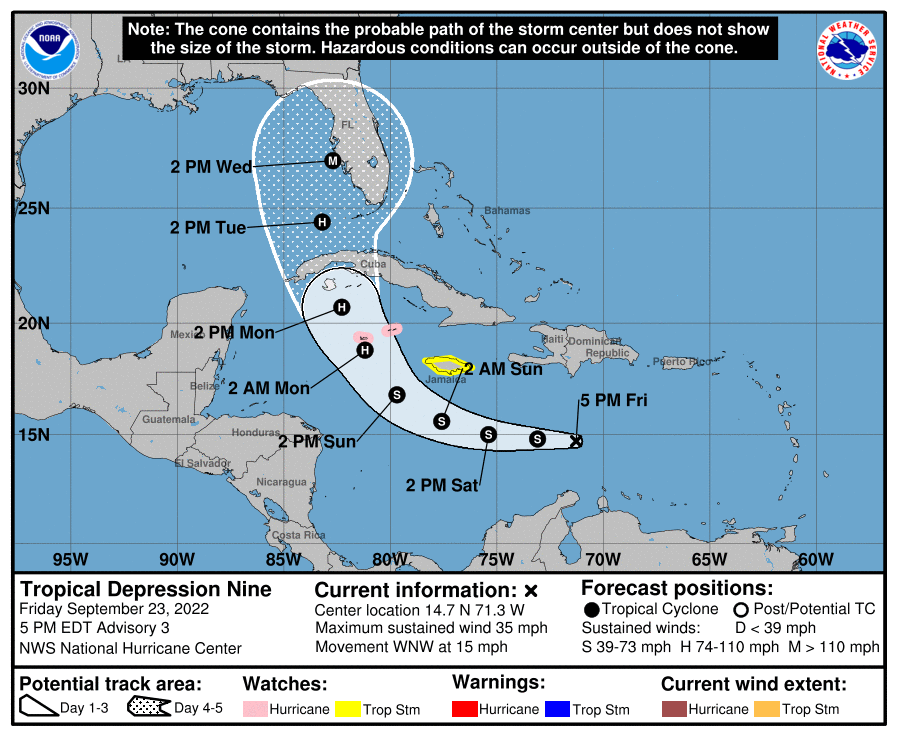
Tomorrow will be a key day for Ian. How much it organizes and intensifies by the end of the day tomorrow will determine how strong it could be when it threatens Cuba and Florida. If it still remains disorganized, then its ceiling could be a Cat 3 at Cuba and a Cat 1-2 at Florida. If it’s already developing an inner core in 24-30 hours…might as well retire the name before landfall. I hope the predicted Gulf shear kicks in enough before Ian’s Florida landfall, assuming it sticks to this track (Cuba landfall between Havana and the western tip) and doesn’t shift east to the point where there will be less time for it to weaken.
3 likes   
Irene '11 Sandy '12 Hermine '16 5/15/2018 Derecho Fay '20 Isaias '20 Elsa '21 Henri '21 Ida '21

I am only a meteorology enthusiast who knows a decent amount about tropical cyclones. Look to the professional mets, the NHC, or your local weather office for the best information.

User avatar
gatorcane
S2K Supporter
S2K Supporter
Posts: 23691
Age: 47
Joined: Sun Mar 13, 2005 3:54 pm
Location: Boca Raton, FL

Re: ATL: NINE - Tropical Depression - Discussion

#706 Postby gatorcane » Fri Sep 23, 2022 3:58 pm

Track shifts a bit west:

Image
1 likes   

Fancy1001
Category 1
Category 1
Posts: 452
Joined: Thu Jul 16, 2020 10:16 pm

Re: ATL: NINE - Tropical Depression - Discussion

#707 Postby Fancy1001 » Fri Sep 23, 2022 4:00 pm

wxman57 wrote:
canebeard wrote:
SouthernBreeze wrote:I see Euro end run approaching SC/NC line at 956 that would be Cat 1?


probably a 3. 943 is typically high pt. of cat 4


Uh, it's only about 1004 mb now. Definitely not a Cat 3 or 4 at present. Don't believe everything you read in the models.


They are obviously talking about at the end of the model, not what the storm is right now.
4 likes   

User avatar
sweetpea
S2K Supporter
S2K Supporter
Posts: 858
Age: 58
Joined: Fri Jun 10, 2005 5:49 pm
Location: Sopchoppy, FL

Re: ATL: NINE - Tropical Depression - Discussion

#708 Postby sweetpea » Fri Sep 23, 2022 4:01 pm

State of emergency for quite a few Florida counties. Stay safe!

https://www.wtxl.com/news/florida-news/ ... rkrGZ8chOA
Last edited by sweetpea on Fri Sep 23, 2022 4:01 pm, edited 1 time in total.
0 likes   

dpep4
Tropical Storm
Tropical Storm
Posts: 198
Joined: Sat Sep 09, 2017 9:04 pm

Re: ATL: NINE - Tropical Depression - Discussion

#709 Postby dpep4 » Fri Sep 23, 2022 4:01 pm

It's not a shoe-in, but they might shift the forecast for Nine west?
Last edited by dpep4 on Fri Sep 23, 2022 4:02 pm, edited 1 time in total.
0 likes   

User avatar
NDG
S2K Supporter
S2K Supporter
Posts: 15446
Joined: Sun Jul 09, 2006 10:14 pm
Location: Orlando, FL

Re: ATL: NINE - Tropical Depression - Discussion

#710 Postby NDG » Fri Sep 23, 2022 4:01 pm


Big time slow down between day 4 & 5.

Anything beyond day 3 the track still subject change.
1 likes   

User avatar
NDG
S2K Supporter
S2K Supporter
Posts: 15446
Joined: Sun Jul 09, 2006 10:14 pm
Location: Orlando, FL

Re: ATL: NINE - Tropical Depression - Discussion

#711 Postby NDG » Fri Sep 23, 2022 4:08 pm

TD 9 is already starting to find better UL winds, I really do think that tonight we will see it become Ian.

Image
9 likes   

AutoPenalti
Category 5
Category 5
Posts: 4030
Age: 29
Joined: Mon Aug 17, 2015 4:16 pm
Location: Ft. Lauderdale, Florida

Re: ATL: NINE - Tropical Depression - Discussion

#712 Postby AutoPenalti » Fri Sep 23, 2022 4:19 pm

NHC cone shifts west, likely sliding with the GFS for now.

Once again, the global models have shifted westward this
cycle during this period, and there remains increased track
uncertainty late in the forecast period once the cyclone emerges
into the southeastern Gulf of Mexico. The latest NHC track forecast
has been adjusted westward from 48-120 h, and it lies near or
slightly east of the latest track consensus aids.
0 likes   
The posts in this forum are NOT official forecasts and should not be used as such. They are just the opinion of the poster and may or may not be backed by sound meteorological data. They are NOT endorsed by any professional institution or STORM2K. For official information, please refer to products from the NHC and NWS.


Model Runs Cheat Sheet:
GFS (5:30 AM/PM, 11:30 AM/PM)
HWRF, GFDL, UKMET, NAVGEM (6:30-8:00 AM/PM, 12:30-2:00 AM/PM)
ECMWF (1:45 AM/PM)

TCVN
is a weighted averaged

User avatar
Hurrilurker
Category 2
Category 2
Posts: 719
Joined: Mon Jun 09, 2003 3:32 pm
Location: San Francisco, CA

Re: ATL: NINE - Tropical Depression - Discussion

#713 Postby Hurrilurker » Fri Sep 23, 2022 4:21 pm

Wow, that spin looks great at the lower levels, just need to stack it up.
0 likes   

Sciencerocks
Category 5
Category 5
Posts: 9155
Age: 39
Joined: Thu Jul 06, 2017 1:51 am

Re: ATL: NINE - Tropical Depression - Discussion

#714 Postby Sciencerocks » Fri Sep 23, 2022 4:24 pm

I'd bet that the recon finds it as a minimum tropical storm when all is said and done. ;) 1004mb pressure.
0 likes   

User avatar
eastcoastFL
Category 5
Category 5
Posts: 3901
Age: 43
Joined: Thu Apr 12, 2007 12:29 pm
Location: Palm City, FL

Re: ATL: NINE - Tropical Depression - Discussion

#715 Postby eastcoastFL » Fri Sep 23, 2022 4:39 pm


I’m interested to see how the future track looks as it crosses the state.
0 likes   
Personal Forecast Disclaimer:
The posts in this forum are NOT official forecast and should not be used as such. They are just the opinion of the poster and may or may not be backed by sound meteorological data. They are NOT endorsed by any professional institution or storm2k.org. For official information, please refer to the NHC and NWS products.

User avatar
skyline385
Category 5
Category 5
Posts: 2728
Age: 35
Joined: Wed Aug 26, 2020 11:15 pm
Location: Houston TX

ATL: NINE - Tropical Depression - Discussion

#716 Postby skyline385 » Fri Sep 23, 2022 4:41 pm

Can’t remember the last time a NHC discussion was so bullish on a NATL system

Recent satellite trends suggest the cyclone may already be nearing a lower shear environment, and once that occurs, the atmospheric and oceanic conditions appear very conducive for strengthening through early next week. As the cyclone moves within a moist and unstable environment over sea-surface temperatures greater than 30 deg C, it is forecast to rapidly intensify over the northwestern Caribbean Sea and continue strengthening while it approaches western Cuba on Monday night. The very warm waters of the southeastern Gulf of Mexico should allow for more strengthening once it crosses Cuba, and the NHC forecast once again shows the system approaching the Florida peninsula as a major hurricane by the middle of next week.
Last edited by skyline385 on Fri Sep 23, 2022 4:52 pm, edited 3 times in total.
4 likes   

User avatar
eastcoastFL
Category 5
Category 5
Posts: 3901
Age: 43
Joined: Thu Apr 12, 2007 12:29 pm
Location: Palm City, FL

Re: ATL: NINE - Tropical Depression - Discussion

#717 Postby eastcoastFL » Fri Sep 23, 2022 4:41 pm

Covering up nicely

Image
3 likes   
Personal Forecast Disclaimer:
The posts in this forum are NOT official forecast and should not be used as such. They are just the opinion of the poster and may or may not be backed by sound meteorological data. They are NOT endorsed by any professional institution or storm2k.org. For official information, please refer to the NHC and NWS products.

User avatar
eastcoastFL
Category 5
Category 5
Posts: 3901
Age: 43
Joined: Thu Apr 12, 2007 12:29 pm
Location: Palm City, FL

Re: ATL: NINE - Tropical Depression - Discussion

#718 Postby eastcoastFL » Fri Sep 23, 2022 4:43 pm

skyline385 wrote:Can’t remember the last time a NHC discussion was so bullish on a NATL system

“Recent satellite trends suggest the cyclone may already be nearing a lower shear environment, and once that occurs, the atmospheric and oceanic conditions appear very conducive for strengthening through early next week. As the cyclone moves within a moist and unstable environment over sea-surface temperatures greater than 30 deg C, it is forecast to rapidly intensify over the northwestern Caribbean Sea and continue strengthening while it approaches western Cuba on Monday night. The very warm waters of the southeastern Gulf of Mexico should allow for more strengthening once it crosses Cuba, and the NHC forecast once again shows the
system approaching the Florida peninsula as a major hurricane by the middle of next week.”


Sent from my iPhone using Tapatalk


It’s one of those rare-ish set ups with a developing storm entering an area of low shear and following a path through some of the warmest waters at the time when those waters are warmer than they’ll be all year.
3 likes   
Personal Forecast Disclaimer:
The posts in this forum are NOT official forecast and should not be used as such. They are just the opinion of the poster and may or may not be backed by sound meteorological data. They are NOT endorsed by any professional institution or storm2k.org. For official information, please refer to the NHC and NWS products.

User avatar
stormhunter7
Category 2
Category 2
Posts: 762
Joined: Mon May 26, 2008 3:13 pm
Location: Panama City Beach, Florida
Contact:

Re: ATL: NINE - Tropical Depression - Discussion

#719 Postby stormhunter7 » Fri Sep 23, 2022 4:47 pm

Increadible imagery coming in on the Floater off GOES-16. Clearly still has shear coming in from the NE, as expected. But look at those tops and ripples coming out. Venting is underway, but it will likley be some time before that surface low tucks up and under the deep convection. When it gets going, I still see this exploding over near the Cayman Islands.
4 likes   
The following post is NOT an official forecast and should not be used as such. It is just the opinion of the poster and may or may not be backed by sound meteorological data. It is NOT endorsed by any professional institution including storm2k.org For Official Information please refer to the NHC and NWS products. http://www.nhc.noaa.gov

User avatar
Iceresistance
Category 5
Category 5
Posts: 9288
Age: 21
Joined: Sat Oct 10, 2020 9:45 am
Location: Tecumseh, OK/Norman, OK

Re: ATL: NINE - Tropical Depression - Discussion

#720 Postby Iceresistance » Fri Sep 23, 2022 4:53 pm

arlwx wrote:Still Nine for now.

Tropical Depression Nine Advisory Number 3
NWS National Hurricane Center Miami FL AL092022
500 PM EDT Fri Sep 23 2022

...HURRICANE WATCH ISSUED FOR THE CAYMAN ISLANDS AND TROPICAL STORM
WATCH ISSUED FOR JAMAICA...
...AIR FORCE HURRICANE HUNTERS EN ROUTE TO INVESTIGATE THE
DEPRESSION...

Now we have intermediate advisories for Nine (9).
3 likes   
Bill 2015 & Beta 2020

Winter 2020-2021 :cold:

All observations are in Tecumseh, OK unless otherwise noted.

Winter posts are focused mainly for Oklahoma & Texas.

Take any of my forecasts with a grain of salt, refer to the NWS, SPC, and NHC for official information

Never say Never with weather! Because ANYTHING is possible!


Return to “2022”

Who is online

Users browsing this forum: No registered users and 2 guests