...TROPICAL STORM IAN FORMS OVER THE CENTRAL CARIBBEAN SEA... ...HURRICANE CONDITIONS POSSIBLE IN THE CAYMAN ISLANDS EARLY MONDAY...
000
WTNT44 KNHC 240245
TCDAT4
Tropical Storm Ian Discussion Number 4
NWS National Hurricane Center Miami FL AL092022
1100 PM EDT Fri Sep 23 2022
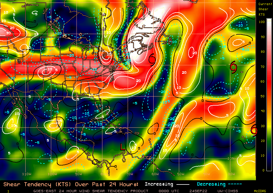
The system remains sheared from the northeast, with the low-level
circulation evident a bit to the east of the deep convection.
Unfortunately, we didn't have the benefit of a reconnaissance
aircraft this evening to sample the winds, but satellite estimates
did increase a bit. TAFB and SAB provided Dvorak classifications
of T2.0/30 kt and T3.0/45 kt, respectively, while the objective
UW-CIMSS ADT and SATCON estimates are at tropical storm intensity.
Based on a blend of these data, the depression is upgraded to
Tropical Storm Ian with 35-kt winds.
Ian's center appears to have been moving more slowly this evening,
and the initial motion estimate is west-northwestward, or 285/10
kt. The track guidance is in good agreement that Ian should turn
westward during the next 12-24 hours while located to the south of
a small mid-level anticyclone centered just north of Hispaniola.
After 24 hours, Ian is expected to begin recurving around the
western side of this high, turning northwestward over the
northwestern Caribbean Sea, and then northward while crossing Cuba
into the Gulf of Mexico and toward Florida. The track models
agree on this general scenario, and the guidance envelope is
flanked by the major global models, with the ECMWF taking a route
over South Florida and the GFS farther west, remaining over the
eastern Gulf of Mexico by day 5. The new NHC forecast lies between
these two scenarios and is not much different from the previous
forecast. The GFS and ECMWF ensembles both show a similar amount
of spread as the deterministic guidance, but both ensemble means
are close to the multi-model consensus aids, which helps to give
more credence to the position of the official forecast.
The moderate deep-layer shear affecting Ian is forecast to decrease
during the next 6 to 12 hours, and the cyclone will be moving over
the very warm waters of the central and northwestern Caribbean Sea,
where sea surface temperatures are between 29 and 31 degrees
Celsius. Intensification is expected to be gradual during the next
36 hours while Ian gets better organized in a lower-shear
environment, but after that time, conditions will be conducive for
faster strengthening. In fact, the NHC intensity forecast
explicitly calls for rapid intensification (RI) between days 2 and
3 while Ian is moving over the northwestern Caribbean Sea toward
western Cuba. It's worth nothing too that the RI indices from
SHIPS are showing a 2-in-3 chance of a 65-kt increase in winds
during the next 3 days, and if that transpires, Ian could be
stronger than what's shown in the official forecast. The storm is
not expected to be over Cuba long enough to cause much weakening,
and the forecast still shows Ian as a major hurricane over the
eastern Gulf of Mexico while approaching the west coast of Florida.
Key Messages:
1. Ian is expected to produce heavy rainfall and instances of
flash flooding and possible mudslides in areas of higher terrain,
particularly over Jamaica and Cuba.
2. Hurricane conditions are possible in the Cayman Islands by
early Monday, with tropical storm conditions possible by late
Sunday. Tropical storm conditions are possible in Jamaica on
Sunday.
3. Early next week, Ian is forecast to move near or over western
Cuba as a strengthening hurricane and then approach the Florida
peninsula at or near major hurricane strength, with the potential
for significant impacts from storm surge, hurricane-force winds,
and heavy rainfall. While it is too soon to determine the
exact magnitude and location of these impacts, residents in Cuba,
the Florida Keys, and the Florida peninsula should ensure they have
their hurricane plan in place and closely monitor forecast updates
through the weekend.
FORECAST POSITIONS AND MAX WINDS
INIT 24/0300Z 14.8N 72.0W 35 KT 40 MPH
12H 24/1200Z 14.7N 73.9W 40 KT 45 MPH
24H 25/0000Z 15.1N 76.3W 45 KT 50 MPH
36H 25/1200Z 16.1N 78.4W 50 KT 60 MPH
48H 26/0000Z 17.6N 80.1W 60 KT 70 MPH
60H 26/1200Z 19.3N 81.5W 75 KT 85 MPH...NEAR GRAND CAYMAN
72H 27/0000Z 21.2N 82.4W 90 KT 105 MPH
96H 28/0000Z 24.9N 83.0W 100 KT 115 MPH
120H 29/0000Z 28.0N 82.0W 95 KT 110 MPH...OVER FLORIDA
$$
Forecaster Berg