ATL: IAN - Post-Tropical - Discussion

Moderator: S2k Moderators

Message
Author
Airboy
Category 1
Category 1
Posts: 439
Joined: Wed Jul 27, 2011 10:41 am

Re: ATL: IAN - Tropical Storm - Discussion

#861 Postby Airboy » Sat Sep 24, 2022 5:54 am

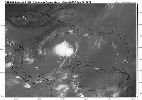
Ivanhater wrote:If the center is indeed down around 13.3 N, that is very far south


Would change a lot in the tracks I guess
1 likes   
Personal Forecast Disclaimer:
The posts in this forum are NOT official forecast and should not be used as such. They are just the opinion of the poster and may or may not be backed by sound meteorological data. They are NOT endorsed by any professional institution or storm2k.org. For official information, please refer to the NHC and NWS products.

User avatar
kevin
Category 5
Category 5
Posts: 2586
Age: 26
Joined: Wed Aug 28, 2019 4:35 am

Re: ATL: IAN - Tropical Storm - Discussion

#862 Postby kevin » Sat Sep 24, 2022 5:56 am

I think the southern center might mean that the HWRF/GFS tracks with (almost) no Cuba interaction & into the panhandle might have more merit than previously thought.
6 likes   

User avatar
tropicwatch
Category 5
Category 5
Posts: 3384
Age: 61
Joined: Sat Jun 02, 2007 10:01 am
Location: Panama City Florida
Contact:

Re: ATL: IAN - Tropical Storm - Discussion

#863 Postby tropicwatch » Sat Sep 24, 2022 5:56 am

Looking like the center is consolidating south of its forecast track. I imagine this will effect the future track somewhat.
3 likes   
Tropicwatch


Agnes 72', Eloise 75, Elena 85', Kate 85', Charley 86', Florence 88', Beryl 94', Dean 95', Erin 95', Opal 95', Earl 98', Georges 98', Ivan 2004', Arlene 2005', Dennis 2005', Ida 2009' Debby 2012' Irma 2017' Michael 2018'

User avatar
Kohlecane
Category 2
Category 2
Posts: 593
Age: 33
Joined: Sun Jul 31, 2011 11:03 pm
Location: Beaufort, SC

Re: ATL: IAN - Tropical Storm - Discussion

#864 Postby Kohlecane » Sat Sep 24, 2022 5:58 am

Wake up and this is Ian... they just had to give it the 'I' name huh! :eek:
1 likes   
Once I see the REDS and GREENS Converge on a Base Velocity. ... I'm There!!

This is NOT an Official Forecast....Just my Opinion. For official information, please refer to the NHC and NWS products.
HIGHLIGHTS : '13 El Reno Tornado : 2013 Storm Chaser Tour, Joaquin; SC flood event, Matthew '16, Lowcountry Snow storm Jan '18

hohnywx
Category 2
Category 2
Posts: 508
Age: 34
Joined: Sun Jul 19, 2009 8:34 pm
Location: Hastings-on-Hudson, NY

Re: ATL: IAN - Tropical Storm - Discussion

#865 Postby hohnywx » Sat Sep 24, 2022 6:02 am

Kohlecane wrote:Wake up and this is Ian... they just had to give it the 'I' name huh! :eek:


Well, that was the next one on the list...
1 likes   

User avatar
REDHurricane
Category 1
Category 1
Posts: 396
Age: 27
Joined: Sun Jul 03, 2022 2:36 pm
Location: Northeast Pacific Ocean

Re: ATL: IAN - Tropical Storm - Discussion

#866 Postby REDHurricane » Sat Sep 24, 2022 6:11 am

Image
2 likes   

cane5
Category 1
Category 1
Posts: 252
Joined: Fri Jul 02, 2021 4:24 pm

Re: ATL: IAN - Tropical Storm - Discussion

#867 Postby cane5 » Sat Sep 24, 2022 6:12 am

kevin wrote:I think the southern center might mean that the HWRF/GFS tracks with (almost) no Cuba interaction & into the panhandle might have more merit than previously thought.


Just curious why might that not take it more south and east of the cone ? Are we certain that trough does not deepen as well there is strong high pressure ridge blocking a more Western direction ?
Last edited by cane5 on Sat Sep 24, 2022 6:15 am, edited 3 times in total.
2 likes   

User avatar
aspen
Category 5
Category 5
Posts: 8818
Joined: Sat Oct 12, 2019 7:10 pm
Location: Connecticut, USA

Re: ATL: IAN - Tropical Storm - Discussion

#868 Postby aspen » Sat Sep 24, 2022 6:12 am

tropicwatch wrote:Looking like the center is consolidating south of its forecast track. I imagine this will effect the future track somewhat.

A SW shift like this could mean it passes through the Yucatan channel and doesn’t make landfall until it reaches Florida, giving it a little extra time to intensify before shear picks up in the Gulf.
3 likes   
Irene '11 Sandy '12 Hermine '16 5/15/2018 Derecho Fay '20 Isaias '20 Elsa '21 Henri '21 Ida '21

I am only a meteorology enthusiast who knows a decent amount about tropical cyclones. Look to the professional mets, the NHC, or your local weather office for the best information.

caneseddy
Category 5
Category 5
Posts: 1172
Joined: Fri Sep 03, 2004 9:31 pm
Location: Plantation, FL

Re: ATL: IAN - Tropical Storm - Discussion

#869 Postby caneseddy » Sat Sep 24, 2022 6:15 am

0 likes   

User avatar
wxman57
Moderator-Pro Met
Moderator-Pro Met
Posts: 22979
Age: 67
Joined: Sat Jun 21, 2003 8:06 pm
Location: Houston, TX (southwest)

Re: ATL: IAN - Tropical Storm - Discussion

#870 Postby wxman57 » Sat Sep 24, 2022 6:17 am

One thing we ARE confident in is that the jet stream will be digging south across the Gulf this weekend. Strong southwest flow aloft will prevail across the NW and north-central Gulf. This will steer Ian to Florida. Possibly as far west as the northern Peninsula or eastern Panhandle. May not be much of a hurricane in that shear, though.
12 likes   

User avatar
Iceresistance
Category 5
Category 5
Posts: 9288
Age: 21
Joined: Sat Oct 10, 2020 9:45 am
Location: Tecumseh, OK/Norman, OK

Re: ATL: IAN - Tropical Storm - Discussion

#871 Postby Iceresistance » Sat Sep 24, 2022 6:22 am

0 likes   
Bill 2015 & Beta 2020

Winter 2020-2021 :cold:

All observations are in Tecumseh, OK unless otherwise noted.

Winter posts are focused mainly for Oklahoma & Texas.

Take any of my forecasts with a grain of salt, refer to the NWS, SPC, and NHC for official information

Never say Never with weather! Because ANYTHING is possible!

KN2731
Tropical Low
Tropical Low
Posts: 21
Age: 23
Joined: Fri Apr 23, 2021 8:13 am
Location: Singapore
Contact:

Re: ATL: IAN - Tropical Storm - Discussion

#872 Postby KN2731 » Sat Sep 24, 2022 6:25 am

Considering surface winds from the dropsondes:
  • No. 4 has 21 kt from SE
  • No. 5 has 23 kt from N
  • No. 6 has 18 kt from N
  • No. 8 has 26 kt from NNE
  • No. 9 has 13 kt from WNW
Image
From this I would estimate a rather N-S elongated surface center somewhere around 14.3°N 74.2°W.

The 700-800 mb "center" is somewhere around 13.5°N 74.6°W albeit not very well defined, as seen from the aircraft flight-level data:
Image

None of this indicates a particularly well-organized nor vertically stacked system at the moment. Personally I think this will get going only after it passes 80°W - but we'll wait and see.
2 likes   

cane5
Category 1
Category 1
Posts: 252
Joined: Fri Jul 02, 2021 4:24 pm

Re: ATL: IAN - Tropical Storm - Discussion

#873 Postby cane5 » Sat Sep 24, 2022 6:27 am

wxman57 wrote:One thing we ARE confident in is that the jet stream will be digging south across the Gulf this weekend. Strong southwest flow aloft will prevail across the NW and north-central Gulf. This will steer Ian to Florida. Possibly as far west as the northern Peninsula or eastern Panhandle. May not be much of a hurricane in that shear, though.


So if anything if you are including the Panhandle based upon the models that say otherwise they would tend to shift West away from the Peninsula ?
0 likes   

User avatar
NDG
S2K Supporter
S2K Supporter
Posts: 15446
Joined: Sun Jul 09, 2006 10:14 pm
Location: Orlando, FL

Re: ATL: IAN - Tropical Storm - Discussion

#874 Postby NDG » Sat Sep 24, 2022 6:31 am

The GFS might be right after all with what it appears reformation further S & W, so a track away from the FL Peninsula. We shall see.

Image
0 likes   

User avatar
cycloneye
Admin
Admin
Posts: 145327
Age: 68
Joined: Thu Oct 10, 2002 10:54 am
Location: San Juan, Puerto Rico

Re: ATL: IAN - Tropical Storm - Discussion

#875 Postby cycloneye » Sat Sep 24, 2022 6:31 am

Breaking news: Plane fixes a center more south than the NHC 5 AM position.

URNT12 KWBC 241124
VORTEX DATA MESSAGE AL092022
A. 24/10:42:29Z
B. 13.54 deg N 074.58 deg W
C. 850 MB 1481 m
D. 1006 mb
E. 300 deg 13 kt
F. NA
G. NA
H. 24 kt
I. 209 deg 1 nm 10:42:14Z
J. 342 deg 9 kt
K. 207 deg 13 nm 10:38:49Z
L. 32 kt
M. 030 deg 134 nm 11:16:28Z
N. 126 deg 31 kt
O. 030 deg 138 nm 11:17:18Z
P. NA
Q. 19 C / 1541 m
R. 18 C / NA
S. 13 / 8
T. 0.01 / 8 nm
U. NOAA2 0309A IAN OB 10
MAX FL WIND 31 KT 030 / 138 NM 11:17:18Z
MAX FL TEMP 19 C 030 / 12 NM FROM FL CNTR
4 likes   
Visit the Caribbean-Central America Weather Thread where you can find at first post web cams,radars
and observations from Caribbean basin members Click Here

User avatar
Iceresistance
Category 5
Category 5
Posts: 9288
Age: 21
Joined: Sat Oct 10, 2020 9:45 am
Location: Tecumseh, OK/Norman, OK

Re: ATL: IAN - Tropical Storm - Discussion

#876 Postby Iceresistance » Sat Sep 24, 2022 6:32 am

When NOAA2 first got into Ian, it had a east wind, now when it crossed the path from the first penetration into the convection, the wind is now Southeast. Ian may have either done a new center reformation or it's slowing down the MLC to the LLC to catch up and start to stack.
1 likes   
Bill 2015 & Beta 2020

Winter 2020-2021 :cold:

All observations are in Tecumseh, OK unless otherwise noted.

Winter posts are focused mainly for Oklahoma & Texas.

Take any of my forecasts with a grain of salt, refer to the NWS, SPC, and NHC for official information

Never say Never with weather! Because ANYTHING is possible!

User avatar
wxman57
Moderator-Pro Met
Moderator-Pro Met
Posts: 22979
Age: 67
Joined: Sat Jun 21, 2003 8:06 pm
Location: Houston, TX (southwest)

Re: ATL: IAN - Tropical Storm - Discussion

#877 Postby wxman57 » Sat Sep 24, 2022 6:35 am

cane5 wrote:
wxman57 wrote:One thing we ARE confident in is that the jet stream will be digging south across the Gulf this weekend. Strong southwest flow aloft will prevail across the NW and north-central Gulf. This will steer Ian to Florida. Possibly as far west as the northern Peninsula or eastern Panhandle. May not be much of a hurricane in that shear, though.


So if anything if you are including the Panhandle based upon the models that say otherwise they would tend to shift West away from the Peninsula ?


Away from the southern peninsula, anyway. Eastern panhandle/northern peninsula. May not be a hurricane up there. May not exit Florida but dissipate in Georgia.
2 likes   

User avatar
gatorcane
S2K Supporter
S2K Supporter
Posts: 23691
Age: 47
Joined: Sun Mar 13, 2005 3:54 pm
Location: Boca Raton, FL

Re: ATL: IAN - Tropical Storm - Discussion

#878 Postby gatorcane » Sat Sep 24, 2022 6:39 am

When you see this wording by the NHC expect some changes to the track in subsequent packages. They are thinking it probably needs to be moved westward.

Given the spread in the guidance, and
the still shifting dynamical models, additional adjustments to the
track forecast may be needed in subsequent advisories.


Finally models except the outlier Euro are coming to grips that it is September and not October. The NE track through the peninsula doesn’t make sense
1 likes   

User avatar
Iceresistance
Category 5
Category 5
Posts: 9288
Age: 21
Joined: Sat Oct 10, 2020 9:45 am
Location: Tecumseh, OK/Norman, OK

Re: ATL: IAN - Tropical Storm - Discussion

#879 Postby Iceresistance » Sat Sep 24, 2022 6:43 am

May have lost the connection to NOAA2.

EDIT: Nevermind, we got a signal now.
1 likes   
Bill 2015 & Beta 2020

Winter 2020-2021 :cold:

All observations are in Tecumseh, OK unless otherwise noted.

Winter posts are focused mainly for Oklahoma & Texas.

Take any of my forecasts with a grain of salt, refer to the NWS, SPC, and NHC for official information

Never say Never with weather! Because ANYTHING is possible!

User avatar
cycloneye
Admin
Admin
Posts: 145327
Age: 68
Joined: Thu Oct 10, 2002 10:54 am
Location: San Juan, Puerto Rico

Re: ATL: IAN - Tropical Storm - Discussion

#880 Postby cycloneye » Sat Sep 24, 2022 6:50 am

Officially more south. It was at 14.7N at 5 AM.

SUMMARY OF 800 AM EDT...1200 UTC...INFORMATION
----------------------------------------------
LOCATION...14.2N 74.5W
ABOUT 300 MI...485 KM SSE OF KINGSTON JAMAICA
ABOUT 570 MI...915 KM SE OF GRAND CAYMAN
MAXIMUM SUSTAINED WINDS...45 MPH...75 KM/H
PRESENT MOVEMENT...WSW OR 255 DEGREES AT 15 MPH...24 KM/H
MINIMUM CENTRAL PRESSURE...1004 MB...29.65 INCHES


Image
3 likes   
Visit the Caribbean-Central America Weather Thread where you can find at first post web cams,radars
and observations from Caribbean basin members Click Here


Return to “2022”

Who is online

Users browsing this forum: No registered users and 3 guests