ATL: IAN - Models
Moderator: S2k Moderators
-
SunnyThoughts
- Category 5

- Posts: 2263
- Joined: Wed Jul 09, 2003 12:42 pm
- Location: Pensacola, Florida
Re: ATL: IAN - Models
Ivanhater wrote:Another huge shift West. Looks like Pensacola/Navarre
We've come full circle, the last 2 or 3 days. 927mb at one point and weakening as it comes in? I've been on the receiving in of canes that were once very strong and then weakening as they came ashore. It's no picnic.
5 likes
-
ConvergenceZone
.gif)
- Category 5
- Posts: 5241
- Joined: Fri Jul 29, 2005 1:40 am
- Location: Northern California
Re: ATL: IAN - Models
Not surprising on the total collapse of Ian. This is exactly what tropical meteorologists Derek Ortt and Wxman said will happen if Ian landfalls in this territory...So all we need to do is hope that GFS and other models shifting west continue to be right over the EURO, and all should end well............
1 likes
-
SEASON_CANCELED

- Category 3

- Posts: 887
- Joined: Mon Jul 06, 2009 5:17 am
- Location: 8 Bit Charlie Sheen
Re: ATL: IAN - Models
GFS ever being right
Lmao
Lets hope it is but im betting on the cone being all over the place
1 likes
i am a big stupid ugly moron with an ugly face and a big butt and my butt stinks and i like to kiss my own butt
Re: ATL: IAN - Models
Ivanhater wrote:Another huge shift West. Looks like Pensacola/Navarre
I hate to say this Mike but CMC seems to be moving W also.Now while I do not use the CMC for real tropics I will give my Canadian friends the benefit of doubt they know more about the upper air patterns over N.America than some of the other models.
2 likes
-
toad strangler

- S2K Supporter

- Posts: 4546
- Joined: Sun Jul 28, 2013 3:09 pm
- Location: Earth
- Contact:
Re: ATL: IAN - Models
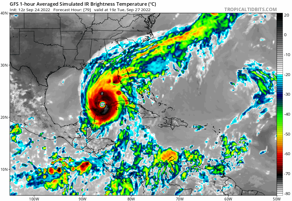
gatorcane wrote:Wow totally collapses in the NGOM
https://i.postimg.cc/zfKGyNmx/gfs-ir-watl-fh79-115.gif
Some pros are saying it’s a possibility if this goes that far west
1 likes
My Weather Station
https://www.wunderground.com/dashboard/pws/KFLPORTS603
https://www.wunderground.com/dashboard/pws/KFLPORTS603
-
Weatherboy1

- Category 5
- Posts: 1190
- Age: 50
- Joined: Mon Jul 05, 2004 1:50 pm
- Location: Jupiter/Sarasota, FL
Re: ATL: IAN - Models
The amount of inconsistency from the GFS is astonishing. Shifts of hundreds of miles every two cycles? Yeesh!
4 likes
Re: ATL: IAN - Models
Weatherboy1 wrote:The amount of inconsistency from the GFS is astonishing. Shifts of hundreds of miles every two cycles? Yeesh!
That could be turned around the lack of others to..............?
0 likes
Re: ATL: IAN - Models
12Z UKMET: strongest run yet and SW of prior run with LF near Tampa area:
TROPICAL STORM IAN ANALYSED POSITION : 14.7N 74.5W
ATCF IDENTIFIER : AL092022
LEAD CENTRAL MAXIMUM WIND
VERIFYING TIME TIME POSITION PRESSURE (MB) SPEED (KNOTS)
-------------- ---- -------- ------------- -------------
1200UTC 24.09.2022 0 14.7N 74.5W 1007 26
0000UTC 25.09.2022 12 14.2N 77.0W 1005 25
1200UTC 25.09.2022 24 14.9N 79.2W 1004 27
0000UTC 26.09.2022 36 15.4N 81.4W 1003 25
1200UTC 26.09.2022 48 17.0N 82.8W 1002 30
0000UTC 27.09.2022 60 18.9N 84.2W 1001 30
1200UTC 27.09.2022 72 20.9N 85.1W 998 34
0000UTC 28.09.2022 84 23.0N 85.6W 996 42
1200UTC 28.09.2022 96 24.5N 85.8W 994 42
0000UTC 29.09.2022 108 25.6N 85.1W 993 51
1200UTC 29.09.2022 120 26.6N 84.1W 991 55
0000UTC 30.09.2022 132 27.0N 83.2W 986 54
1200UTC 30.09.2022 144 28.3N 82.5W 987 47
Last edited by LarryWx on Sat Sep 24, 2022 11:24 am, edited 1 time in total.
1 likes
Personal Forecast Disclaimer:
The posts in this forum are NOT official forecasts and should not be used as such. They are just the opinion of the poster and may or may not be backed by sound meteorological data. They are NOT endorsed by any professional institution or storm2k.org. For official information, please refer to the NHC and NWS products.
The posts in this forum are NOT official forecasts and should not be used as such. They are just the opinion of the poster and may or may not be backed by sound meteorological data. They are NOT endorsed by any professional institution or storm2k.org. For official information, please refer to the NHC and NWS products.


Re: ATL: IAN - Models
Javlin wrote:Ivanhater wrote:Another huge shift West. Looks like Pensacola/Navarre
I hate to say this Mike but CMC seems to be moving W also.Now while I do not use the CMC for real tropics I will give my Canadian friends the benefit of doubt they know more about the upper air patterns over N.America than some of the other models.
Thinking NHC will be moving the cone again for the 18z runs. This storm has been a head scratcher from day 1. I thought there was suppose to be strong westerly flow across the gulf that was suppose to direct this toward the peninsula? I wonder what changed that dynamic?
1 likes
-
Poonwalker
- Category 1

- Posts: 270
- Joined: Tue Sep 20, 2022 11:12 am
Re: ATL: IAN - Models
They are doing dropsonds to sample the trough dynamics later today. That data should be fed into the 0000z run. Should get a better idea on this just after midnight.
4 likes
-
MississippiWx

- S2K Supporter
- Posts: 1720
- Joined: Sat Aug 14, 2010 1:44 pm
- Location: Hattiesburg, Mississippi
Re: ATL: IAN - Models
Very large west shifts from both the CMC and GFS this afternoon. This is nuts. This goes back to the initial formation and consolidation of the center in the Caribbean. The trend has been a farther southwest development of the center thanks to the northeasterly shear. This is what the GFS was showing for so long before abandoning it for a day or so. Have we come back to that again? Not convinced until the Euro caves to it.
1 likes
This post is not an official forecast and should not be used as such. It is just the opinion of MississippiWx and may or may not be backed by sound meteorological data. It is not endorsed by any professional institution including storm2k.org. For Official Information please refer to the NHC and NWS products.
-
toad strangler
- S2K Supporter
- Posts: 4546
- Joined: Sun Jul 28, 2013 3:09 pm
- Location: Earth
- Contact:
Re: ATL: IAN - Models
toad strangler wrote:gatorcane wrote:Wow totally collapses in the NGOM
https://i.postimg.cc/zfKGyNmx/gfs-ir-watl-fh79-115.gif
Some pros are saying it’s a possibility if this goes that far west
Yeah, in this set up I’m riding the Euro like Secretariat. Which has also trended west but keeps it’s pants on lol.
0 likes
My Weather Station
https://www.wunderground.com/dashboard/pws/KFLPORTS603
https://www.wunderground.com/dashboard/pws/KFLPORTS603
-
Ivanhater

- Storm2k Moderator

- Posts: 11221
- Age: 39
- Joined: Fri Jul 01, 2005 8:25 am
- Location: Pensacola
Re: RE: Re: ATL: IAN - Models
pgoss11 wrote:Javlin wrote:Ivanhater wrote:Another huge shift West. Looks like Pensacola/Navarre
I hate to say this Mike but CMC seems to be moving W also.Now while I do not use the CMC for real tropics I will give my Canadian friends the benefit of doubt they know more about the upper air patterns over N.America than some of the other models.
Thinking NHC will be moving the cone again for the 18z runs. This storm has been a head scratcher from day 1. I thought there was suppose to be strong westerly flow across the gulf that was suppose to direct this toward the peninsula? I wonder what changed that dynamic?
Yeah. Cmc is right on top of Gfs. Last few cycles have been showing a stronger ridge over Florida pushing it further West. We shall see

Sent from my LM-G900TM using Tapatalk
3 likes
Michael
Re: ATL: IAN - Models
Poonwalker wrote:They are doing dropsonds to sample the trough dynamics later today. That data should be fed into the 0000z run. Should get a better idea on this just after midnight.
I would hope that some have been setting up some weather balloons already over the Canada and northern regions of the US?Old school maybe but seemed to work in the old days of forcasting.
1 likes

Re: ATL: IAN - Models
pgoss11 wrote:Javlin wrote:Ivanhater wrote:Another huge shift West. Looks like Pensacola/Navarre
I hate to say this Mike but CMC seems to be moving W also.Now while I do not use the CMC for real tropics I will give my Canadian friends the benefit of doubt they know more about the upper air patterns over N.America than some of the other models.
Thinking NHC will be moving the cone again for the 18z runs. This storm has been a head scratcher from day 1. I thought there was suppose to be strong westerly flow across the gulf that was suppose to direct this toward the peninsula? I wonder what changed that dynamic?
If you look at the GFS runs, two high pressure systems pinch off that doorway for Ian as it approaches. Looking at the Euro, it uses the low pressure as an escape hatch still which brings it over Florida. Will all depend on if that area of low pressure is still accessible to Ian when it gets closer to the eastern GOM or if the high pressure systems build in and block it
Last edited by jfk08c on Sat Sep 24, 2022 11:26 am, edited 1 time in total.
4 likes
-
Blown Away

- S2K Supporter
- Posts: 10253
- Joined: Wed May 26, 2004 6:17 am
Re: ATL: IAN - Models
Javlin wrote:Ivanhater wrote:Another huge shift West. Looks like Pensacola/Navarre
I hate to say this Mike but CMC seems to be moving W also.Now while I do not use the CMC for real tropics I will give my Canadian friends the benefit of doubt they know more about the upper air patterns over N.America than some of the other models.
Well, if Ian moves to Panhandle the CMC sniffed out first. Imagine that!
Can’t remember when 2 global models moved wildly outside the NHC cone. Those NHC folks earning their $$$ with this one!
Last edited by Blown Away on Sat Sep 24, 2022 11:27 am, edited 2 times in total.
3 likes
Hurricane Eye Experience: David 79, Irene 99, Frances 04, Jeanne 04, Wilma 05… Hurricane Brush Experience: Andrew 92, Erin 95, Floyd 99, Matthew 16, Irma 17, Ian 22, Nicole 22…

Re: ATL: IAN - Models
At this point it would not shock me for the GFS to plow Ian into Yuc at 0z.
3 likes
Re: ATL: IAN - Models
Blown Away wrote:Javlin wrote:Ivanhater wrote:Another huge shift West. Looks like Pensacola/Navarre
I hate to say this Mike but CMC seems to be moving W also.Now while I do not use the CMC for real tropics I will give my Canadian friends the benefit of doubt they know more about the upper air patterns over N.America than some of the other models.
Well, if Ian moves to Panhandle the CMC sniffed out first. Imagine that!
Can’t remember when 2 global models moved wildly outside the NHC cone. Those NHC folks earning their $$$ with this one!
Katrina....remember Dereck Ortt sniffed out landfall 72hrs before the NHC.
Last edited by Javlin on Sat Sep 24, 2022 11:29 am, edited 1 time in total.
1 likes

Re: ATL: IAN - Models
There's a reason when the cone of uncertainty is so wide between day 4 & 5.
4 likes
Who is online
Users browsing this forum: No registered users and 40 guests