

WPAC: NORU - Post-Tropical
Moderator: S2k Moderators
Re: WPAC: NORU - Typhoon
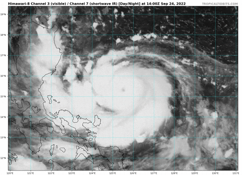
Noru is a perfect example as to why the JTWC/JMA should have intermediate/special advisories like the NHC. In situations like this with a RI'ing system very close to land, intensity estimates and warnings need to be updated sooner than the typical 6-hour advisories. This is still stuck at 75 kt from the JTWC for a few more hours, but it already looks like a Cat 4, far exceeding the highest forecast intensity from 12z. A special advisory also means there'll be less of a massive jump between standard advisory intensities. If they did one now and put Noru at 100-110 kt, then they can upgrade it to a Cat 4 at 18z, and it wouldn't be as massive of a jump.
8 likes
Irene '11 Sandy '12 Hermine '16 5/15/2018 Derecho Fay '20 Isaias '20 Elsa '21 Henri '21 Ida '21
I am only a meteorology enthusiast who knows a decent amount about tropical cyclones. Look to the professional mets, the NHC, or your local weather office for the best information.
I am only a meteorology enthusiast who knows a decent amount about tropical cyclones. Look to the professional mets, the NHC, or your local weather office for the best information.
Re: WPAC: NORU - Typhoon
aspen wrote:Noru is a perfect example as to why the JTWC/JMA should have intermediate/special advisories like the NHC. In situations like this with a RI'ing system very close to land, intensity estimates and warnings need to be updated sooner than the typical 6-hour advisories. This is still stuck at 75 kt from the JTWC for a few more hours, but it already looks like a Cat 4, far exceeding the highest forecast intensity from 12z. A special advisory also means there'll be less of a massive jump between standard advisory intensities. If they did one now and put Noru at 100-110 kt, then they can upgrade it to a Cat 4 at 18z, and it wouldn't be as massive of a jump.
https://i.imgur.com/2W21mnF.jpg
Agree 100% with you Aspen....well said
0 likes

Re: WPAC: NORU - Typhoon
WMG eye in W, T7.0. If the CMG ring thickens a little it'll be T7.5 - and we're still 4 hours from sunrise (and about 12 from landfall).

2 likes
-
dexterlabio
- Category 5

- Posts: 3499
- Joined: Sat Oct 24, 2009 11:50 pm
Re: WPAC: NORU - Typhoon
Anyone else getting Goni vibes from this…the SW dive, the compact yet robust structure
4 likes
Personal Forecast Disclaimer:
The posts in this forum are NOT official forecast and should not be used as such. They are just the opinion of the poster and may or may not be backed by sound meteorological data. They are NOT endorsed by any professional institution or storm2k.org. For official information, please refer to the NHC and NWS products.
The posts in this forum are NOT official forecast and should not be used as such. They are just the opinion of the poster and may or may not be backed by sound meteorological data. They are NOT endorsed by any professional institution or storm2k.org. For official information, please refer to the NHC and NWS products.
Re: WPAC: NORU - Typhoon
KN2731 wrote:WMG eye in W, T7.0. If the CMG ring thickens a little it'll be T7.5 - and we're still 4 hours from sunrise (and about 12 from landfall).
https://cdn.discordapp.com/attachments/627514985764880455/1023293514034982933/unknown.png
The JTWC/JMA are so far behind this it’s not even funny.
2 likes
Irene '11 Sandy '12 Hermine '16 5/15/2018 Derecho Fay '20 Isaias '20 Elsa '21 Henri '21 Ida '21
I am only a meteorology enthusiast who knows a decent amount about tropical cyclones. Look to the professional mets, the NHC, or your local weather office for the best information.
I am only a meteorology enthusiast who knows a decent amount about tropical cyclones. Look to the professional mets, the NHC, or your local weather office for the best information.

Re: WPAC: NORU - Typhoon
TPPN11 PGTW 241844
A. TYPHOON 18W (NORU)
B. 24/1740Z
C. 15.08N
D. 124.78E
E. ONE/HMWRI8
F. T5.5/5.5/D2.5/24HRS STT: S0.0/03HRS
G. IR/EIR
H. REMARKS: 05A/PBO IRREG EYE/ANMTN. OW EYE SURROUNDED BY W YIELDS
AN E# OF 6.0. ADDED 0.5 EYE ADJUSTMENT FOR CMG, TO YIELD A DT OF
6.5. MET YIELDS 4.5. PT YIELDS 5.5. CONSTRAINT LIMITED BY FT 1.0
MORE THAN MET. DBO CONSTRAINT.
I. ADDITIONAL POSITIONS: NONE
HEINS
WTPQ51 RJTD 241800
RSMC TROPICAL CYCLONE ADVISORY
NAME TY 2216 NORU (2216)
ANALYSIS
PSTN 241800UTC 15.2N 124.8E GOOD
MOVE W 12KT
PRES 955HPA
MXWD 085KT
GUST 120KT
50KT 50NM
30KT 150NM SOUTHWEST 120NM NORTHEAST
FORECAST
12HF 250600UTC 15.1N 122.8E 35NM 70%
MOVE W 10KT
PRES 950HPA
MXWD 090KT
GUST 130KT
RSMC TROPICAL CYCLONE ADVISORY
NAME TY 2216 NORU (2216)
ANALYSIS
PSTN 241800UTC 15.2N 124.8E GOOD
MOVE W 12KT
PRES 955HPA
MXWD 085KT
GUST 120KT
50KT 50NM
30KT 150NM SOUTHWEST 120NM NORTHEAST
FORECAST
12HF 250600UTC 15.1N 122.8E 35NM 70%
MOVE W 10KT
PRES 950HPA
MXWD 090KT
GUST 130KT
0 likes
ヤンデレ女が寝取られるているのを見たい!!!
ECMWF ensemble NWPAC plots: https://ecmwfensnwpac.imgbb.com/
Multimodel NWPAC plots: https://multimodelnwpac.imgbb.com/
GFS Ensemble NWPAC plots (16 & 35 day forecast): https://gefsnwpac.imgbb.com/
Plots updated automatically
ECMWF ensemble NWPAC plots: https://ecmwfensnwpac.imgbb.com/
Multimodel NWPAC plots: https://multimodelnwpac.imgbb.com/
GFS Ensemble NWPAC plots (16 & 35 day forecast): https://gefsnwpac.imgbb.com/
Plots updated automatically
-
Hurricane2022

- Category 5
- Posts: 2016
- Joined: Tue Aug 23, 2022 11:38 pm
- Location: Araçatuba, Brazil
Re: WPAC: NORU - Typhoon
Hayabusa wrote:TPPN11 PGTW 241844
A. TYPHOON 18W (NORU)
B. 24/1740Z
C. 15.08N
D. 124.78E
E. ONE/HMWRI8
F. T5.5/5.5/D2.5/24HRS STT: S0.0/03HRS
G. IR/EIR
H. REMARKS: 05A/PBO IRREG EYE/ANMTN. OW EYE SURROUNDED BY W YIELDS
AN E# OF 6.0. ADDED 0.5 EYE ADJUSTMENT FOR CMG, TO YIELD A DT OF
6.5. MET YIELDS 4.5. PT YIELDS 5.5. CONSTRAINT LIMITED BY FT 1.0
MORE THAN MET. DBO CONSTRAINT.
I. ADDITIONAL POSITIONS: NONE
HEINSWTPQ51 RJTD 241800
RSMC TROPICAL CYCLONE ADVISORY
NAME TY 2216 NORU (2216)
ANALYSIS
PSTN 241800UTC 15.2N 124.8E GOOD
MOVE W 12KT
PRES 955HPA
MXWD 085KT
GUST 120KT
50KT 50NM
30KT 150NM SOUTHWEST 120NM NORTHEAST
FORECAST
12HF 250600UTC 15.1N 122.8E 35NM 70%
MOVE W 10KT
PRES 950HPA
MXWD 090KT
GUST 130KT
JTWC might estimate 100 - 115 KT for 2100Z Warning
0 likes
Sorry for the bad English sometimes...!
For reliable and detailed information for any meteorological phenomenon, please consult the National Hurricane Center, Joint Typhoon Warning Center , or your local Meteo Center.
--------
ECCE OMNIA NOVA FACIAM (Ap 21,5).
For reliable and detailed information for any meteorological phenomenon, please consult the National Hurricane Center, Joint Typhoon Warning Center , or your local Meteo Center.
--------
ECCE OMNIA NOVA FACIAM (Ap 21,5).
-
xtyphooncyclonex

- Category 5
- Posts: 3890
- Age: 24
- Joined: Sat Dec 08, 2012 9:07 am
- Location: Cebu City
- Contact:
Re: WPAC: NORU - Typhoon
As much as I'd wanna say "leave this to the weather nerds," people's lives are at risk. The more south this goes, the more densely populated the areas are. This is really going to catch people off guard and I can't imagine the Metro going through what we did last December.
If this were OTS I prolly wouldn't be this bothered. But sadly that's not the case. This is no way a 85 kt system...
If this were OTS I prolly wouldn't be this bothered. But sadly that's not the case. This is no way a 85 kt system...
3 likes
REMINDER: My opinions that I, or any other NON Pro-Met in this forum, are unofficial. Please do not take my opinions as an official forecast and warning. I am NOT a meteorologist. Following my forecasts blindly may lead to false alarm, danger and risk if official forecasts from agencies are ignored.
Re: WPAC: NORU - Typhoon
TXPQ21 KNES 241842
TCSWNP
A. 18W (NORU)
B. 24/1730Z
C. 15.1N
D. 124.8E
E. ONE/HIMAWARI-8
F. T6.0/6.0
G. IR/EIR/SWIR
H. REMARKS...AN OW EYE SURROUNDED BY A CMG RING AND EMBEDDED IN W
RESULTS IN A DT OF 6.5 AFTER ADDING AN EYE ADJUSTMENT OF 0.5. THE MET IS
4.5 BASED ON A 24 HOUR RAPID DEVELOPING TREND. THE PT IS 5.0. THE FT IS
BASED ON THE 6 HOUR AVERAGE DT JUSTIFYING BREAKING CONTRAINTS LIMITING
THE FT TO A CHANGE IN 1.5 OVER 12 HOURS.
I. ADDL POSITIONS
NIL
...GATLING
0 likes
ヤンデレ女が寝取られるているのを見たい!!!
ECMWF ensemble NWPAC plots: https://ecmwfensnwpac.imgbb.com/
Multimodel NWPAC plots: https://multimodelnwpac.imgbb.com/
GFS Ensemble NWPAC plots (16 & 35 day forecast): https://gefsnwpac.imgbb.com/
Plots updated automatically
ECMWF ensemble NWPAC plots: https://ecmwfensnwpac.imgbb.com/
Multimodel NWPAC plots: https://multimodelnwpac.imgbb.com/
GFS Ensemble NWPAC plots (16 & 35 day forecast): https://gefsnwpac.imgbb.com/
Plots updated automatically
Re: WPAC: NORU - Typhoon
2022SEP24 184000 5.6 954 105 5.6 5.7 7.0 1.3T/6hr OFF OFF OFF OFF 14.56 -76.60 EYE 11 IR 45.1 15.14 -124.53 ARCHER HIM-8 25.7
0 likes
ヤンデレ女が寝取られるているのを見たい!!!
ECMWF ensemble NWPAC plots: https://ecmwfensnwpac.imgbb.com/
Multimodel NWPAC plots: https://multimodelnwpac.imgbb.com/
GFS Ensemble NWPAC plots (16 & 35 day forecast): https://gefsnwpac.imgbb.com/
Plots updated automatically
ECMWF ensemble NWPAC plots: https://ecmwfensnwpac.imgbb.com/
Multimodel NWPAC plots: https://multimodelnwpac.imgbb.com/
GFS Ensemble NWPAC plots (16 & 35 day forecast): https://gefsnwpac.imgbb.com/
Plots updated automatically
-
cycloneye

- Admin

- Posts: 149214
- Age: 69
- Joined: Thu Oct 10, 2002 10:54 am
- Location: San Juan, Puerto Rico
Re: WPAC: NORU - Typhoon
18W NORU 220924 1800 15.1N 124.7E WPAC 130 930
4 likes
Visit the Caribbean-Central America Weather Thread where you can find at first post web cams,radars
and observations from Caribbean basin members Click Here
and observations from Caribbean basin members Click Here
-
REDHurricane

- Category 1

- Posts: 438
- Age: 28
- Joined: Sun Jul 03, 2022 2:36 pm
- Location: Northeast Pacific Ocean
Re: WPAC: NORU - Typhoon
cycloneye wrote:18W NORU 220924 1800 15.1N 124.7E WPAC 130 930
So the GFS was right deepening this to 930 mb before it started to back off developing it
Hayabusa wrote:Now that's an invest, it's time to not ignore the GFS. Latest GFS 18Z is showing an intense typhoon before a Luzon landfall. Euro was showing development few days ago but it backed off
https://i.imgur.com/cWkVkPA.png
4 likes
ヤンデレ女が寝取られるているのを見たい!!!
ECMWF ensemble NWPAC plots: https://ecmwfensnwpac.imgbb.com/
Multimodel NWPAC plots: https://multimodelnwpac.imgbb.com/
GFS Ensemble NWPAC plots (16 & 35 day forecast): https://gefsnwpac.imgbb.com/
Plots updated automatically
ECMWF ensemble NWPAC plots: https://ecmwfensnwpac.imgbb.com/
Multimodel NWPAC plots: https://multimodelnwpac.imgbb.com/
GFS Ensemble NWPAC plots (16 & 35 day forecast): https://gefsnwpac.imgbb.com/
Plots updated automatically
-
ElectricStorm

- Category 5
- Posts: 5127
- Age: 25
- Joined: Tue Aug 13, 2019 11:23 pm
- Location: Norman, OK
Re: WPAC: NORU - Typhoon
Absolute nightmare for the Philippines, I don't really see anything preventing this from being a Cat 5 landfall
0 likes
B.S Meteorology, University of Oklahoma '25
Please refer to the NHC, NWS, or SPC for official information.
Please refer to the NHC, NWS, or SPC for official information.
-
doomhaMwx

- Category 5
- Posts: 2487
- Age: 27
- Joined: Tue Apr 18, 2017 4:01 am
- Location: Baguio/Benguet, Philippines
- Contact:
Re: WPAC: NORU - Typhoon
12Z estimate was also revised to 90kts from 75kts
18W NORU 220924 1800 15.1N 124.7E WPAC 130 930
18W NORU 220924 1200 15.4N 125.9E WPAC 90 968
18W NORU 220924 0600 15.8N 126.7E WPAC 65 984
18W NORU 220924 1200 15.4N 125.9E WPAC 90 968
18W NORU 220924 0600 15.8N 126.7E WPAC 65 984
2 likes
Re: WPAC: NORU - Typhoon
Revision
18W NORU 220924 1800 15.1N 124.7E WPAC 135 925
1 likes
ヤンデレ女が寝取られるているのを見たい!!!
ECMWF ensemble NWPAC plots: https://ecmwfensnwpac.imgbb.com/
Multimodel NWPAC plots: https://multimodelnwpac.imgbb.com/
GFS Ensemble NWPAC plots (16 & 35 day forecast): https://gefsnwpac.imgbb.com/
Plots updated automatically
ECMWF ensemble NWPAC plots: https://ecmwfensnwpac.imgbb.com/
Multimodel NWPAC plots: https://multimodelnwpac.imgbb.com/
GFS Ensemble NWPAC plots (16 & 35 day forecast): https://gefsnwpac.imgbb.com/
Plots updated automatically
-
MarioProtVI
- Category 5
- Posts: 1034
- Age: 24
- Joined: Sun Sep 29, 2019 7:33 pm
- Location: New Jersey
Re: WPAC: NORU - Typhoon
[youtube]https://youtu.be/rFeVfwDvTyM[/youtube]
My reaction to Noru the last few hours
My reaction to Noru the last few hours
2 likes
Re: WPAC: NORU - Typhoon
Latest warning expecting 145 knots before landfall 

0 likes
ヤンデレ女が寝取られるているのを見たい!!!
ECMWF ensemble NWPAC plots: https://ecmwfensnwpac.imgbb.com/
Multimodel NWPAC plots: https://multimodelnwpac.imgbb.com/
GFS Ensemble NWPAC plots (16 & 35 day forecast): https://gefsnwpac.imgbb.com/
Plots updated automatically
ECMWF ensemble NWPAC plots: https://ecmwfensnwpac.imgbb.com/
Multimodel NWPAC plots: https://multimodelnwpac.imgbb.com/
GFS Ensemble NWPAC plots (16 & 35 day forecast): https://gefsnwpac.imgbb.com/
Plots updated automatically
Re: WPAC: NORU - Typhoon
Guys, check out the rainfall on the Euro map. A long stretch of fairly heavy rain all the way into Myanmmar.
0 likes

Re: WPAC: NORU - Typhoon
Tomorrow might end up being a historic date for the Philippines with this CAT 5 strike upcoming, holy cow!!
0 likes
Georges '98, Irene '99, Frances '04, Jeanne '04, Katrina '05, Wilma '05, Gustav '08, Isaac '12, Matthew '16, Florence '18, Michael '18, Ian '22
Who is online
Users browsing this forum: No registered users and 15 guests