
ATL: IAN - Models
Moderator: S2k Moderators
-
MississippiWx

- S2K Supporter

- Posts: 1720
- Joined: Sat Aug 14, 2010 1:44 pm
- Location: Hattiesburg, Mississippi
Re: ATL: IAN - Models
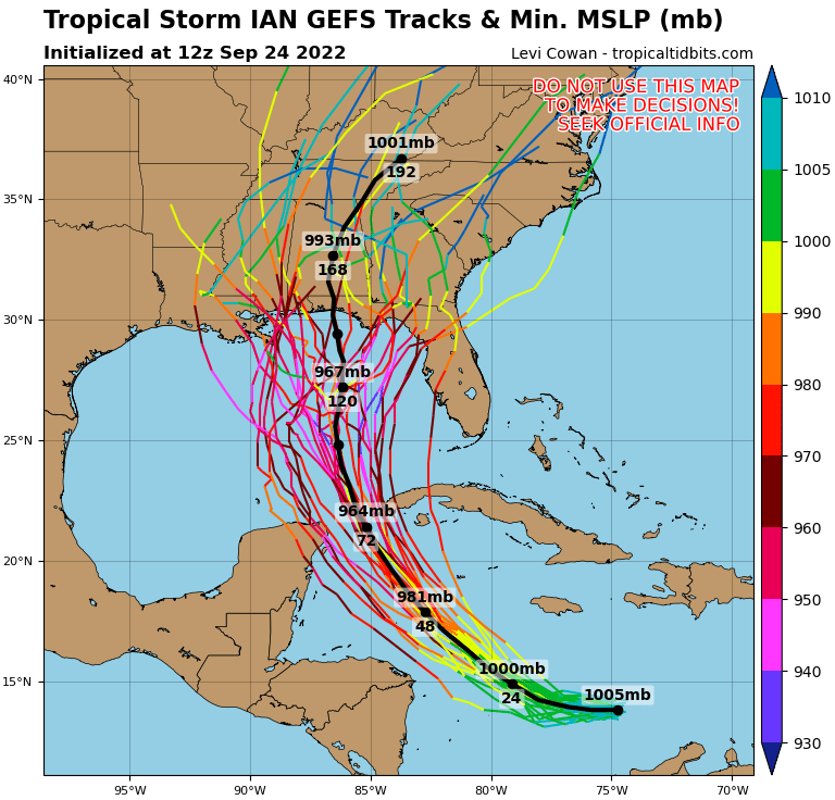
BobHarlem wrote:Euro ensembles.
https://i.imgur.com/HVTQeqb.jpg
Pretty large shift west by the Euro ensembles as well.
3 likes
This post is not an official forecast and should not be used as such. It is just the opinion of MississippiWx and may or may not be backed by sound meteorological data. It is not endorsed by any professional institution including storm2k.org. For Official Information please refer to the NHC and NWS products.
-
Frank P
- S2K Supporter
- Posts: 2779
- Joined: Fri Aug 29, 2003 10:52 am
- Location: Biloxi Beach, Ms
- Contact:
Re: ATL: IAN - Models
utweather wrote:Are the models that are showing a more northern gulf coast landfall showing a weaker storm and stall after that? Just wondering about flooding concerns.
On the coast people should be worried about a surge concern, even if the system weakens from an upper end Cat 4 to a Cat 1 it’s going to bring a huge surge with it, especially if it moving slow and perpendicular to the coast line.
6 likes
-
gatorcane

- S2K Supporter
- Posts: 23708
- Age: 48
- Joined: Sun Mar 13, 2005 3:54 pm
- Location: Boca Raton, FL
Re: ATL: IAN - Models
BobHarlem wrote:Euro ensembles.
https://i.imgur.com/HVTQeqb.jpg
The mean track (black line) doesn’t actually landfall in the Tampa area but if Ian took a track like that it would be quite devastating for that area being on the dirty side not to mention the storm surge that would result.
1 likes
-
SEASON_CANCELED

- Category 3

- Posts: 887
- Joined: Mon Jul 06, 2009 5:17 am
- Location: 8 Bit Charlie Sheen
Re: ATL: IAN - Models
gatorcane wrote:BobHarlem wrote:Euro ensembles.
https://i.imgur.com/HVTQeqb.jpg
The mean track (black line) doesn’t actually landfall in the Tampa area but if Ian took a track like that it would be quite devastating foe that area being on the dirty side.
That would obliterate St. Pete/ Pasco
1 likes
i am a big stupid ugly moron with an ugly face and a big butt and my butt stinks and i like to kiss my own butt
-
Ivanhater

- Storm2k Moderator

- Posts: 11221
- Age: 39
- Joined: Fri Jul 01, 2005 8:25 am
- Location: Pensacola
Re: ATL: IAN - Models
Almost all of the strong Euro members hook NW into the Florida panhandle
3 likes
Michael
-
Poonwalker
- Category 1

- Posts: 270
- Joined: Tue Sep 20, 2022 11:12 am
Re: ATL: IAN - Models
SEASON_CANCELED wrote:
Something is really bothering me about this Run, Primarily that Cuba appears to have no effect on it
Also the angle compared to GFS....GFS shows 100 miles to the west on first frame. These Tracks are entirely dependant on positioning below cuba. We will have to wait and see when that turn happens
Dunno. Watching with anxiety.
Ian will be in 32 degree bath water on approach to Cuba with very favorable conditions. It also won’t spend much time over land.
2 likes
-
cycloneye

- Admin

- Posts: 149506
- Age: 69
- Joined: Thu Oct 10, 2002 10:54 am
- Location: San Juan, Puerto Rico
Re: ATL: IAN - Models
2 likes
Visit the Caribbean-Central America Weather Thread where you can find at first post web cams,radars
and observations from Caribbean basin members Click Here
and observations from Caribbean basin members Click Here
-
SconnieCane
- Category 5

- Posts: 1013
- Joined: Thu Aug 02, 2018 5:29 pm
- Location: Madison, WI
Re: ATL: IAN - Models
Seeing the excessive ridging/left-biased Euro (Laura into Galveston, anyone?) and the right/poleward-biased GFS (Florence barely scrapes the OBX and OTS) essentially playing for the opposite teams for so long is just bizarre.
Sent from my Pixel 4a using Tapatalk
Sent from my Pixel 4a using Tapatalk
0 likes
-
toad strangler

- S2K Supporter
- Posts: 4546
- Joined: Sun Jul 28, 2013 3:09 pm
- Location: Earth
- Contact:
Re: ATL: IAN - Models
tolakram wrote:So when both models are moving west, what is the trend?
The west trend can not be denied. Makes me wonder if the pendulum has to swing back at some point. I can’t see this going much further west and also I can’t see this being locked in either this far out. Sooo… on to the next suite!
5 likes
My Weather Station
https://www.wunderground.com/dashboard/pws/KFLPORTS603
https://www.wunderground.com/dashboard/pws/KFLPORTS603
-
Frank P
- S2K Supporter
- Posts: 2779
- Joined: Fri Aug 29, 2003 10:52 am
- Location: Biloxi Beach, Ms
- Contact:
Re: ATL: IAN - Models
So is the Euro now trending towards the GFS?. haha, who would have thought that even as early as this morning. I love the discombobulation of tracking the models more than 5 days out… they always want surprise me. And by tomorrow who knows where Ian will be heading, but sooner or later they better start getting their act together. That was a pretty big shift of the TVCN and really caught me by surprise.. wonder what’s going on in the minds of the NHC forecasters, discussion at 5 should be really interesting.
4 likes
-
skyline385

- Category 5
- Posts: 2728
- Age: 35
- Joined: Wed Aug 26, 2020 11:15 pm
- Location: Houston TX
Re: ATL: IAN - Models
BobHarlem wrote:Euro ensembles.
https://i.imgur.com/HVTQeqb.jpg
Where do you get the EPS on weathermodels with mean shown? I never saw that before and have been using the regular EPS cyclones from model lab.
0 likes
-
gatorcane
- S2K Supporter
- Posts: 23708
- Age: 48
- Joined: Sun Mar 13, 2005 3:54 pm
- Location: Boca Raton, FL
Re: ATL: IAN - Models
The mean track of the Euro ensembles and GFS ensembles is now about 100 miles west of the west coast of Florida. I expect the NHC will shift west but not as much as the mean track or TVCN. That would be landfall into the Big Bend.
Last edited by gatorcane on Sat Sep 24, 2022 3:04 pm, edited 2 times in total.
1 likes


Re: ATL: IAN - Models
toad strangler wrote:tolakram wrote:So when both models are moving west, what is the trend?
The west trend can not be denied. Makes me wonder if the pendulum has to swing back at some point. I can’t see this going much further west and also I can’t see this being locked in either this far out. Sooo… on to the next suite!
100% agree! The amount of changes in the ensembles over the last few days is crazy and I don’t think we’re quite done yet with changes.
4 likes

Re: ATL: IAN - Models
NDG wrote:It will all come down to how fast and deep the trough digs down to pull Ian north, the difference between the Euro and GFS.
https://i.imgur.com/8d7ASRf.jpg
So the 12Z Euro is going to annihilate the Tampa bay area because the 585 MB steering layer isobar hasn't made it past Pittsburg landing at hour 93 when Ian is a deep 929 MB monster? And Gums is going to be running his generator on slush hydrogen for the first two weeks of October because the the same line on the GFS model did?
This is going to take me 6 hours just to read all the model output for one run!
Last edited by Nimbus on Sat Sep 24, 2022 3:06 pm, edited 1 time in total.
2 likes
-
Poonwalker
- Category 1
- Posts: 270
- Joined: Tue Sep 20, 2022 11:12 am
Re: ATL: IAN - Models
tolakram wrote:So when both models are moving west, what is the trend?
West! I usually don’t get too caught up when a system is 5 days out though. Within 2-3 days it’s a different story. There will be more weight on the solutions after the radiosonde data is fed into the 0z models tonight. Right now the best scenario to hope for is the trough lifting out quicker like the GFS is showing. The Euro has a potentially catastrophic event unfolding for coastal communities in Florida.
1 likes
-
cycloneye
- Admin
- Posts: 149506
- Age: 69
- Joined: Thu Oct 10, 2002 10:54 am
- Location: San Juan, Puerto Rico
Re: ATL: IAN - Models
toad strangler wrote:tolakram wrote:So when both models are moving west, what is the trend?
The west trend can not be denied. Makes me wonder if the pendulum has to swing back at some point. I can’t see this going much further west and also I can’t see this being locked in either this far out. Sooo… on to the next suite!
The 00z suite will have the data from the gulfstream jet.
4 likes
Visit the Caribbean-Central America Weather Thread where you can find at first post web cams,radars
and observations from Caribbean basin members Click Here
and observations from Caribbean basin members Click Here
-
skyline385
- Category 5
- Posts: 2728
- Age: 35
- Joined: Wed Aug 26, 2020 11:15 pm
- Location: Houston TX
Re: ATL: IAN - Models
Frank P wrote:So is the Euro now trending towards the GFS?. haha, who would have thought that even as early as this morning. I love the discombobulation of tracking the models more than 5 days out… they always want surprise me. And by tomorrow who knows where Ian will be heading, but sooner or later they better start getting their act together. That was a pretty big shift of the TVCN and really caught me by surprise.. wonder what’s going on in the minds of the NHC forecasters, discussion at 5 should be really interesting.
Called it out yesterday when the 18Z EPS first started showing signs of a shift west
skyline385 wrote:toad strangler wrote:skyline385 wrote:18Z EPS, seems like a decent shift west towards the GFS
https://i.imgur.com/otBED5N.png
https://i.imgur.com/yBzB6yg.png
That ain’t a shift. It’s a consolidation.
The mean track shifted west
1 likes
-
ConvergenceZone
.gif)
- Category 5
- Posts: 5241
- Joined: Fri Jul 29, 2005 1:40 am
- Location: Northern California
Re: ATL: IAN - Models
I will say that if it happens to get up to Cat 4 strength in the Southern Gulf, it will very difficult for it to weaken all the way down to a tropical storm, even with the west shifts....I think it will still be a hurricane....With tiny systems I can see extreme shear causing that type of weakening, but not with average size hurricanes....It can happen, but I think it would be highly unlikely...........
0 likes
-
Poonwalker
- Category 1
- Posts: 270
- Joined: Tue Sep 20, 2022 11:12 am
Re: ATL: IAN - Models
Frank P wrote:utweather wrote:Are the models that are showing a more northern gulf coast landfall showing a weaker storm and stall after that? Just wondering about flooding concerns.
On the coast people should be worried about a surge concern, even if the system weakens from an upper end Cat 4 to a Cat 1 it’s going to bring a huge surge with it, especially if it moving slow and perpendicular to the coast line.
There’s also the huge amount of rain that will surely unfold. Like days of rain in one area with banding that doesn’t move. Still a major flood event.
0 likes
Who is online
Users browsing this forum: No registered users and 18 guests