ATL: IAN - Post-Tropical - Discussion

Moderator: S2k Moderators

Message
Author
User avatar
karenfromheaven
Tropical Storm
Tropical Storm
Posts: 171
Age: 71
Joined: Thu Sep 09, 2004 4:45 pm
Location: North Naples, FL

Re: ATL: IAN - Tropical Storm - Discussion

#1361 Postby karenfromheaven » Sun Sep 25, 2022 9:33 am

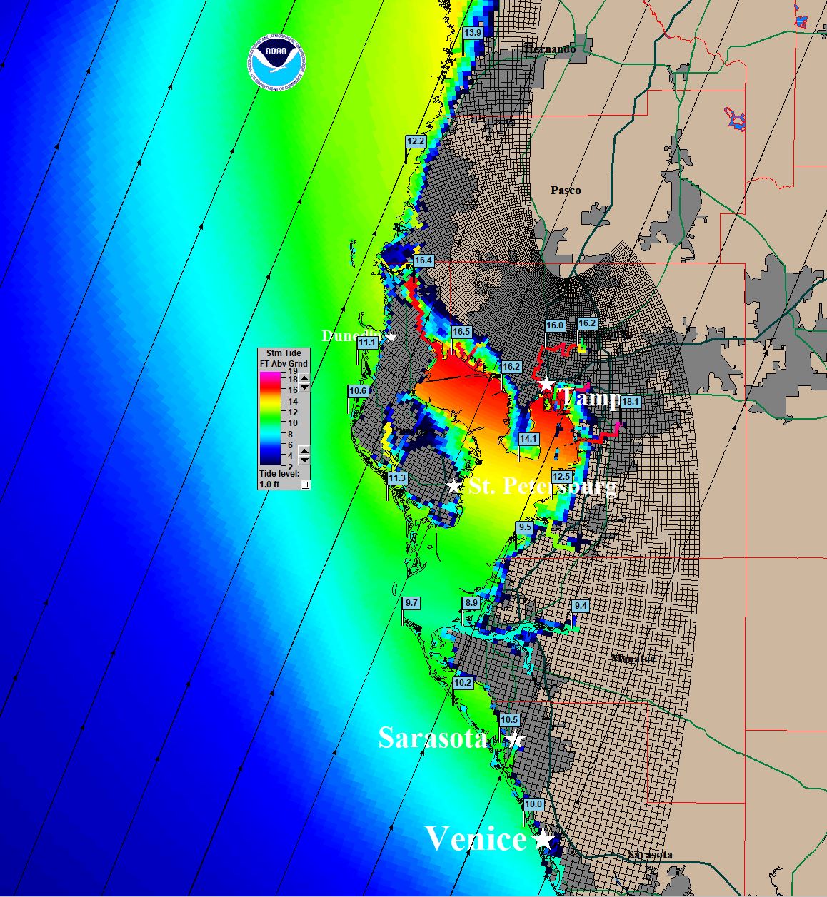
wxman57 wrote:To help with the decision whether to shutter and/or evacuate. The SLOSH graphic below represents a "what if?" for a landfall near Tampa of an average-sized hurricane that is borderline Cat 2/Cat 3. If you're in one of those very low-lying communities on the coast, then your home/business will be inundated by lots of water. Tampa hasn't seen this kind of surge since the 1940s or 1950s. It's only a POSSIBLE surge for now. Ian would have to track inland just west of Tampa. Blue flags indicate water depth (not subtracting land, though all flags touch the water, not land).

http://wxman57.com/images/SLOSHTPA.JPG

http://wxman57.com/images/SLOSHTPA.JPG

The SLOSH models are no joke. If there were a storm where this plot needed to be seriously considered, Ian is it. Don't wait until the last minute and stuck in a low spot while evacuating on the highway .
2 likes   

User avatar
ronjon
Category 5
Category 5
Posts: 4822
Joined: Fri Aug 19, 2005 5:17 pm
Location: Hernando Beach, FL

Re: ATL: IAN - Tropical Storm - Discussion

#1362 Postby ronjon » Sun Sep 25, 2022 9:36 am

CronkPSU wrote:
ScottNAtlanta wrote:I'm surprised even with the synoptic data that NOAA got last night the EURO hasn't budged. They had a lot of new data that made it into the latest runs.


Could say the same thing about the GFS refusing to budge with the new data, one would think ONE of them would have budged but nope


I'm pretty shocked there is such a spread in guidance between GFS and Euro. It's about 150 miles apart at 72-96 hours out. I think most people are watch and wait mode now with so much uncertainty and a rather anemic looking storm. Have to say the Euro really hasn't budged in the last 4 to 5 runs (landfall Naples to bradenton). This uncertainty is stressful for us living along the gulf coast.
4 likes   

User avatar
tarheelprogrammer
S2K Supporter
S2K Supporter
Posts: 1793
Joined: Mon Mar 28, 2016 9:25 pm
Location: Raleigh, NC area (Garner, NC)

Re: ATL: IAN - Tropical Storm - Discussion

#1363 Postby tarheelprogrammer » Sun Sep 25, 2022 9:38 am

blp wrote:Intensity on this pathetic.

https://i.ibb.co/drcgNFr/recon-AF301-0909-A-IAN.png


He is a struggling right now. Looking anemic. How is this expected to get to cat 4 or 5?
1 likes   
My posts are not official forecasts. They are just my opinion and may or may not be backed by sound meteorological data. They are NOT endorsed by any professional institution or storm2k.org. For official information, please refer to the NHC and NWS products.

User avatar
toad strangler
S2K Supporter
S2K Supporter
Posts: 4543
Joined: Sun Jul 28, 2013 3:09 pm
Location: Earth
Contact:

Re: ATL: IAN - Tropical Storm - Discussion

#1364 Postby toad strangler » Sun Sep 25, 2022 9:39 am

tarheelprogrammer wrote:
blp wrote:Intensity on this pathetic.

https://i.ibb.co/drcgNFr/recon-AF301-0909-A-IAN.png


He is a struggling right now. Looking anemic. How is this expected to get to cat 4 or 5?


Who is expecting that? Not me. High end 2 perhaps a 3 for a brief moment.
1 likes   

SconnieCane
Category 4
Category 4
Posts: 998
Joined: Thu Aug 02, 2018 5:29 pm
Location: Madison, WI

Re: RE: Re: ATL: IAN - Tropical Storm - Discussion

#1365 Postby SconnieCane » Sun Sep 25, 2022 9:39 am

Weatherboy1 wrote:
Jr0d wrote:Going to rely on points and how far Ian is away from those points now until until north of Key West to get an idea of how much of an impact we will likely experience.

First point was 15n 80w,(missed just right). Next point for me is 17N 81W, if it hits or misses right we can expect more of an impact, NHC official forecast is left of that point).

Ian appears to be moving NW now and not forecast to move due north until it clears Cuba, obviously if it turns NNW then N before Cuba, this is bad for me and the peninsula. As we know, the further south at land fall the stronger the storm will be.

Not a forecast by any means, but I am NOT expecting a panhandle landfall. My best guess is Fort Myers to Cedar Key. The angle of the storm.vs coastline make it impossible to narrow it down.

While obviously a much different set up, Charley hooking
right earlier than expected and strengthening comes to mind as a bad outlier


My strong belief based on what I’m seeing out there is that IF Ian tracks in a direction out of line with the official forecast, it’ll be to the south and East not north and west. In other words, I think the chance is higher Ian landfalls south of, say, Tampa than well north


I feel like this is a case of north now = south later. As is the faster/more north Ian gets now, the more likely it gets caught by the trough and pulled east into the peninsula rather than being left behind and limping into the northern Gulf.

Sent from my Pixel 4a using Tapatalk
7 likes   

User avatar
Hypercane_Kyle
Category 5
Category 5
Posts: 3352
Joined: Sat Mar 07, 2015 7:58 pm
Location: Cape Canaveral, FL

Re: ATL: IAN - Tropical Storm - Discussion

#1366 Postby Hypercane_Kyle » Sun Sep 25, 2022 9:39 am

toad strangler wrote:
tarheelprogrammer wrote:
blp wrote:Intensity on this pathetic.

https://i.ibb.co/drcgNFr/recon-AF301-0909-A-IAN.png


He is a struggling right now. Looking anemic. How is this expected to get to cat 4 or 5?


Who is expecting that? Not me. High end 2 perhaps a 3 for a brief moment.


NHC pretty explicitly states Cat. 4 peak...
11 likes   
My posts are my own personal opinion, defer to the National Hurricane Center (NHC) and other NOAA products for decision making during hurricane season.

User avatar
Iceresistance
Category 5
Category 5
Posts: 9288
Age: 21
Joined: Sat Oct 10, 2020 9:45 am
Location: Tecumseh, OK/Norman, OK

Re: ATL: IAN - Tropical Storm - Discussion

#1367 Postby Iceresistance » Sun Sep 25, 2022 9:41 am

blp wrote:Intensity on this pathetic.

https://i.ibb.co/drcgNFr/recon-AF301-0909-A-IAN.png


The pressure has gone up, it appears that a center reformation is very likely.
0 likes   
Bill 2015 & Beta 2020

Winter 2020-2021 :cold:

All observations are in Tecumseh, OK unless otherwise noted.

Winter posts are focused mainly for Oklahoma & Texas.

Take any of my forecasts with a grain of salt, refer to the NWS, SPC, and NHC for official information

Never say Never with weather! Because ANYTHING is possible!

User avatar
eastcoastFL
Category 5
Category 5
Posts: 3901
Age: 43
Joined: Thu Apr 12, 2007 12:29 pm
Location: Palm City, FL

Re: ATL: IAN - Tropical Storm - Discussion

#1368 Postby eastcoastFL » Sun Sep 25, 2022 9:41 am

chaser1 wrote:
CronkPSU wrote:
ScottNAtlanta wrote:I'm surprised even with the synoptic data that NOAA got last night the EURO hasn't budged. They had a lot of new data that made it into the latest runs.


Could say the same thing about the GFS refusing to budge with the new data, one would think ONE of them would have budged but nope


Great point. Though this conversation is drifting into the "Models thread", I'd be more curious if (and how) the new data impacted the ensembles


The NHC this morning pretty much has the same questions. The disco was saying how despite data from flights and weather balloon launches across the country the models haven’t changed and still have a massive spread after day 3. So it seems beyond day 3 it’s still a coin flip as to where this thing will end up.
1 likes   
Personal Forecast Disclaimer:
The posts in this forum are NOT official forecast and should not be used as such. They are just the opinion of the poster and may or may not be backed by sound meteorological data. They are NOT endorsed by any professional institution or storm2k.org. For official information, please refer to the NHC and NWS products.

User avatar
eastcoastFL
Category 5
Category 5
Posts: 3901
Age: 43
Joined: Thu Apr 12, 2007 12:29 pm
Location: Palm City, FL

Re: ATL: IAN - Tropical Storm - Discussion

#1369 Postby eastcoastFL » Sun Sep 25, 2022 9:43 am

toad strangler wrote:
tarheelprogrammer wrote:
blp wrote:Intensity on this pathetic.

https://i.ibb.co/drcgNFr/recon-AF301-0909-A-IAN.png


He is a struggling right now. Looking anemic. How is this expected to get to cat 4 or 5?


Who is expecting that? Not me. High end 2 perhaps a 3 for a brief moment.


These NHC guys seem to disagree. They continue to forecast rapid intensification on each update


Ian remains within an environment that appears quite conducive for
strengthening. Once the circulation become more vertically
coherent, low vertical wind shear conditions and high ocean heat
content are expected to allow for rapid intensification while Ian
moves over the northwestern Caribbean Sea. The Deterministic to
Probabilistic Statistical Rapid Intensification Index (DTOPS) once
again calls for a 90 percent chance of rapid strengthening during
the following 48- and 72-hour forecast periods. The NHC intensity
forecast calls for rapid intensification to begin later today, and
forecasts Ian to be a major hurricane when it nears western
Cuba in about 48 hours. The latest official intensity forecast
shows a similar peak intensity around 72 h over the southeastern
Gulf of Mexico as the previous advisory.
4 likes   
Personal Forecast Disclaimer:
The posts in this forum are NOT official forecast and should not be used as such. They are just the opinion of the poster and may or may not be backed by sound meteorological data. They are NOT endorsed by any professional institution or storm2k.org. For official information, please refer to the NHC and NWS products.

User avatar
eastcoastFL
Category 5
Category 5
Posts: 3901
Age: 43
Joined: Thu Apr 12, 2007 12:29 pm
Location: Palm City, FL

Re: RE: Re: ATL: IAN - Tropical Storm - Discussion

#1370 Postby eastcoastFL » Sun Sep 25, 2022 9:45 am

SconnieCane wrote:
Weatherboy1 wrote:
Jr0d wrote:Going to rely on points and how far Ian is away from those points now until until north of Key West to get an idea of how much of an impact we will likely experience.

First point was 15n 80w,(missed just right). Next point for me is 17N 81W, if it hits or misses right we can expect more of an impact, NHC official forecast is left of that point).

Ian appears to be moving NW now and not forecast to move due north until it clears Cuba, obviously if it turns NNW then N before Cuba, this is bad for me and the peninsula. As we know, the further south at land fall the stronger the storm will be.

Not a forecast by any means, but I am NOT expecting a panhandle landfall. My best guess is Fort Myers to Cedar Key. The angle of the storm.vs coastline make it impossible to narrow it down.

While obviously a much different set up, Charley hooking
right earlier than expected and strengthening comes to mind as a bad outlier


My strong belief based on what I’m seeing out there is that IF Ian tracks in a direction out of line with the official forecast, it’ll be to the south and East not north and west. In other words, I think the chance is higher Ian landfalls south of, say, Tampa than well north


I feel like this is a case of north now = south later. As is the faster/more north Ian gets now, the more likely it gets caught by the trough and pulled east into the peninsula rather than being left behind and limping into the northern Gulf.

Sent from my Pixel 4a using Tapatalk


That’s my understanding as well. If it tracks on the northern/eastern side of the cone for now and crosses Cuba a little sooner it will be in time to meet the trough who will yank it NE. Slower and more to the west it misses that train.
2 likes   
Personal Forecast Disclaimer:
The posts in this forum are NOT official forecast and should not be used as such. They are just the opinion of the poster and may or may not be backed by sound meteorological data. They are NOT endorsed by any professional institution or storm2k.org. For official information, please refer to the NHC and NWS products.

User avatar
Emmett_Brown
Category 5
Category 5
Posts: 1432
Joined: Wed Aug 24, 2005 9:10 pm
Location: Sarasota FL

Re: ATL: IAN - Tropical Storm - Discussion

#1371 Postby Emmett_Brown » Sun Sep 25, 2022 9:45 am

So far, the biggest change in structure that I see is that recon found a decent sized area of W winds. So it could be argued that Ian is finally more than just a wave axis. The potential for Ian to be a major is obviously still there, but thankfully he's taking his time.
1 likes   

User avatar
Jr0d
S2K Supporter
S2K Supporter
Posts: 1409
Joined: Tue Aug 27, 2019 10:52 am
Location: Cayo Hueso

Re: ATL: IAN - Tropical Storm - Discussion

#1372 Postby Jr0d » Sun Sep 25, 2022 9:45 am


That is a but concerning to see so much area vulnerable to 15'+ of surge. With Ian, I hope the compact size will limit surge.

My grandmom and aunt live in the Clearwater/Safety Harbor area. My grandmom's place is the stronger structure and around 30' above sea level. I will have to give them a call soon and see what their plan is. With her being 95 years old evacuating is difficult but not as bad having no power for an extended period of time.
2 likes   

cane5
Category 1
Category 1
Posts: 252
Joined: Fri Jul 02, 2021 4:24 pm

Re: ATL: IAN - Tropical Storm - Discussion

#1373 Postby cane5 » Sun Sep 25, 2022 9:49 am

tarheelprogrammer wrote:
blp wrote:Intensity on this pathetic.

https://i.ibb.co/drcgNFr/recon-AF301-0909-A-IAN.png


He is a struggling right now. Looking anemic. How is this expected to get to cat 4 or 5?


Nobody is projecting that perhaps a 3. It’s called rapid intensivication where a storm can change wind strength upwards to 50 miles an hour in one day.
Last edited by cane5 on Sun Sep 25, 2022 9:51 am, edited 1 time in total.
3 likes   

User avatar
Jr0d
S2K Supporter
S2K Supporter
Posts: 1409
Joined: Tue Aug 27, 2019 10:52 am
Location: Cayo Hueso

Re: ATL: IAN - Tropical Storm - Discussion

#1374 Postby Jr0d » Sun Sep 25, 2022 9:49 am

Emmett_Brown wrote:.... The potential for Ian to be a major is obviously still there, but thankfully he's taking his time.


I am about 99% certain this will be a major.

Fir now Ian is taking his time, but once this gets stacked it will be off to the races.

If Ian is not a hurricane by this time tomorrow, I will be shocked.
2 likes   

tolakram
Admin
Admin
Posts: 20009
Age: 62
Joined: Sun Aug 27, 2006 8:23 pm
Location: Florence, KY (name is Mark)

Re: ATL: IAN - Tropical Storm - Discussion

#1375 Postby tolakram » Sun Sep 25, 2022 9:52 am

Nothing unexpected yet. HWRF has Ian starting at 1001 and rising to 1004 before starting a slow ramp up to 995 some time this evening. If it's still weak by recon tonight then something unexpected is going on in my opinion.
8 likes   
M a r k
- - - - -
Join us in chat: Storm2K Chatroom Invite. Android and IOS apps also available.

The posts in this forum are NOT official forecasts and should not be used as such. Posts are NOT endorsed by any professional institution or STORM2K.org. For official information and forecasts, please refer to NHC and NWS products.

User avatar
MGC
S2K Supporter
S2K Supporter
Posts: 5899
Joined: Sun Mar 23, 2003 9:05 pm
Location: Pass Christian MS, or what is left.

Re: ATL: IAN - Tropical Storm - Discussion

#1376 Postby MGC » Sun Sep 25, 2022 9:52 am

Ian has plenty of water to traverse and time to intensify into a major. Expect the center to locate under the MLC today. For those of you concerned with surge, I'd keep an eye on its wind radius. Prepare for the worst, hope for the best......MGC
3 likes   

crimi481
Category 2
Category 2
Posts: 602
Joined: Thu Sep 09, 2004 4:47 pm

Re: ATL: IAN - Tropical Storm - Discussion

#1377 Postby crimi481 » Sun Sep 25, 2022 9:54 am

Fiona's tail gas been disrupting Ian. Amazing?
2 likes   

User avatar
Hurricaneman
Category 5
Category 5
Posts: 7351
Age: 45
Joined: Tue Aug 31, 2004 3:24 pm
Location: central florida

Re: ATL: IAN - Tropical Storm - Discussion

#1378 Postby Hurricaneman » Sun Sep 25, 2022 9:54 am

There is a new convective burst over the center, looks to be fully aligned now, let the games begin
5 likes   

User avatar
toad strangler
S2K Supporter
S2K Supporter
Posts: 4543
Joined: Sun Jul 28, 2013 3:09 pm
Location: Earth
Contact:

Re: ATL: IAN - Tropical Storm - Discussion

#1379 Postby toad strangler » Sun Sep 25, 2022 9:55 am

eastcoastFL wrote:
toad strangler wrote:
tarheelprogrammer wrote:
He is a struggling right now. Looking anemic. How is this expected to get to cat 4 or 5?


Who is expecting that? Not me. High end 2 perhaps a 3 for a brief moment.


These NHC guys seem to disagree. They continue to forecast rapid intensification on each update


Ian remains within an environment that appears quite conducive for
strengthening. Once the circulation become more vertically
coherent, low vertical wind shear conditions and high ocean heat
content are expected to allow for rapid intensification while Ian
moves over the northwestern Caribbean Sea. The Deterministic to
Probabilistic Statistical Rapid Intensification Index (DTOPS) once
again calls for a 90 percent chance of rapid strengthening during
the following 48- and 72-hour forecast periods. The NHC intensity
forecast calls for rapid intensification to begin later today, and
forecasts Ian to be a major hurricane when it nears western
Cuba in about 48 hours. The latest official intensity forecast
shows a similar peak intensity around 72 h over the southeastern
Gulf of Mexico as the previous advisory.


Ya before crossing the lattitude of Cuba I can see that. Afterwards,

Farther East = deeper
Farther West = weaker
1 likes   

tolakram
Admin
Admin
Posts: 20009
Age: 62
Joined: Sun Aug 27, 2006 8:23 pm
Location: Florence, KY (name is Mark)

Re: ATL: IAN - Tropical Storm - Discussion

#1380 Postby tolakram » Sun Sep 25, 2022 10:01 am

Structure looks great, but so far no big convection.

Image
5 likes   
M a r k
- - - - -
Join us in chat: Storm2K Chatroom Invite. Android and IOS apps also available.

The posts in this forum are NOT official forecasts and should not be used as such. Posts are NOT endorsed by any professional institution or STORM2K.org. For official information and forecasts, please refer to NHC and NWS products.


Return to “2022”

Who is online

Users browsing this forum: No registered users and 18 guests