ATL: IAN - Models

Moderator: S2k Moderators

Message
Author
User avatar
skyline385
Category 5
Category 5
Posts: 2728
Age: 35
Joined: Wed Aug 26, 2020 11:15 pm
Location: Houston TX

Re: ATL: IAN - Models

#2641 Postby skyline385 » Mon Sep 26, 2022 1:44 am

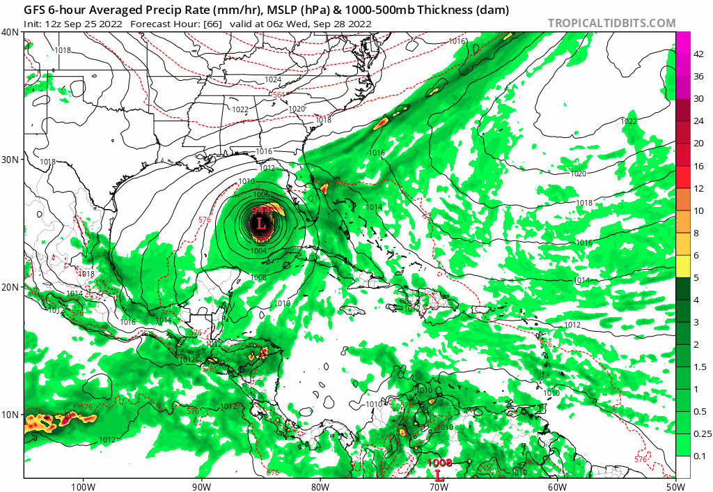
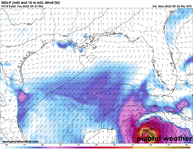
Stormgodess wrote:Question: With a strong storm, that weakens.. let's say Ian gets to Cat 4 but weakens to Cat 2 before landfall. What about storm surge? Does the surge drop along with the weakening storm, or can it still hold on to pushing higher waters it gathered when much stronger?

Does that question make sense? :double:

Water in the ocean has a lot of inertia compared to air so while the winds would drop off quickly it would be much longer for the storm surge to weaken.


Sent from my iPhone using Tapatalk
4 likes   

NFLnut
Category 2
Category 2
Posts: 541
Joined: Sun Aug 29, 2004 7:37 pm

Re: ATL: IAN - Models

#2642 Postby NFLnut » Mon Sep 26, 2022 2:04 am

Can anyone explain why the 00Z GFS moved WEST in this run from 18Z. Did they forgot dropsonde again or something? Look at 72hr specifically.

https://imgur.com/a/vx2q7AG
Last edited by NFLnut on Mon Sep 26, 2022 2:13 am, edited 3 times in total.
0 likes   

User avatar
NDG
S2K Supporter
S2K Supporter
Posts: 15446
Joined: Sun Jul 09, 2006 10:14 pm
Location: Orlando, FL

Re: ATL: IAN - Models

#2643 Postby NDG » Mon Sep 26, 2022 2:10 am

06z TVCN still slightly to the right of the NHC track.

Image
2 likes   

User avatar
Bocadude85
Category 5
Category 5
Posts: 2991
Age: 38
Joined: Mon Apr 18, 2005 2:20 pm
Location: Honolulu,Hi

Re: ATL: IAN - Models

#2644 Postby Bocadude85 » Mon Sep 26, 2022 2:19 am

NDG wrote:06z TVCN still slightly to the right of the NHC track.

https://i.imgur.com/BLClAUy.gif


I think the NHC is getting fairly close to the eventual track, perhaps another shift east and they will be right on the money.. I wouldn’t be shocked to see the shear push Ian into the coast a little south of Tampa however.
2 likes   

User avatar
NDG
S2K Supporter
S2K Supporter
Posts: 15446
Joined: Sun Jul 09, 2006 10:14 pm
Location: Orlando, FL

Re: ATL: IAN - Models

#2645 Postby NDG » Mon Sep 26, 2022 2:29 am

A closer look at the 06z TVCN, it actually moved about 10 miles west, previous was over Clearwater & Crystal River.

Image
3 likes   

User avatar
chris_fit
Category 5
Category 5
Posts: 3222
Age: 42
Joined: Wed Sep 10, 2003 11:58 pm
Location: Tampa Bay Area, FL

Re: ATL: IAN - Models

#2646 Postby chris_fit » Mon Sep 26, 2022 3:43 am

00Z EPS - 2 views of same run

Image


Image
1 likes   

User avatar
chris_fit
Category 5
Category 5
Posts: 3222
Age: 42
Joined: Wed Sep 10, 2003 11:58 pm
Location: Tampa Bay Area, FL

Re: ATL: IAN - Models

#2647 Postby chris_fit » Mon Sep 26, 2022 3:46 am

00Z GFS Ens - 2 views of same run. Wayyyy offshore Tampa.

Image

Image
1 likes   

User avatar
N2FSU
S2K Supporter
S2K Supporter
Posts: 1062
Joined: Thu Sep 04, 2003 2:04 pm
Location: Tallahassee, FL

Re: ATL: IAN - Models

#2648 Postby N2FSU » Mon Sep 26, 2022 3:46 am

0z Euro with the stall and northward crawl
Image
Image
Image


Sent from my iPad using Tapatalk
2 likes   

User avatar
Bocadude85
Category 5
Category 5
Posts: 2991
Age: 38
Joined: Mon Apr 18, 2005 2:20 pm
Location: Honolulu,Hi

Re: ATL: IAN - Models

#2649 Postby Bocadude85 » Mon Sep 26, 2022 4:26 am

6Z ICON has landfall around Sarasota and continuing NE across the state exiting around St.Augustine
4 likes   

User avatar
Bocadude85
Category 5
Category 5
Posts: 2991
Age: 38
Joined: Mon Apr 18, 2005 2:20 pm
Location: Honolulu,Hi

Re: ATL: IAN - Models

#2650 Postby Bocadude85 » Mon Sep 26, 2022 4:46 am

6z GFS at 36 hours is a decent amount northeast of the 0z
2 likes   

User avatar
eastcoastFL
Category 5
Category 5
Posts: 3901
Age: 43
Joined: Thu Apr 12, 2007 12:29 pm
Location: Palm City, FL

Re: ATL: IAN - Models

#2651 Postby eastcoastFL » Mon Sep 26, 2022 4:49 am

Bocadude85 wrote:6Z ICON has landfall around Sarasota and continuing NE across the state exiting around St.Augustine


Was that about the same as last run?
1 likes   
Personal Forecast Disclaimer:
The posts in this forum are NOT official forecast and should not be used as such. They are just the opinion of the poster and may or may not be backed by sound meteorological data. They are NOT endorsed by any professional institution or storm2k.org. For official information, please refer to the NHC and NWS products.

User avatar
Blown Away
S2K Supporter
S2K Supporter
Posts: 10146
Joined: Wed May 26, 2004 6:17 am

Re: ATL: IAN - Models

#2652 Postby Blown Away » Mon Sep 26, 2022 4:50 am

Image
06z GFS 48 hr Trending E again
2 likes   
Hurricane Eye Experience: David 79, Irene 99, Frances 04, Jeanne 04, Wilma 05... EYE COMING MY WAY IN 2024…
Hurricane Brush Experience: Andrew 92, Erin 95, Floyd 99, Matthew 16, Irma 17, Ian 22, Nicole 22…

Fancy1001
Category 1
Category 1
Posts: 452
Joined: Thu Jul 16, 2020 10:16 pm

Re: ATL: IAN - Models

#2653 Postby Fancy1001 » Mon Sep 26, 2022 4:53 am

The GFS has started turning Northeast Towards Tampa at 66 hours, let’s see if that continues or if it starts to head north again. Either way it’s a decent amount east of the previous run
2 likes   

User avatar
Blown Away
S2K Supporter
S2K Supporter
Posts: 10146
Joined: Wed May 26, 2004 6:17 am

Re: ATL: IAN - Models

#2654 Postby Blown Away » Mon Sep 26, 2022 4:55 am

Image
2 likes   
Hurricane Eye Experience: David 79, Irene 99, Frances 04, Jeanne 04, Wilma 05... EYE COMING MY WAY IN 2024…
Hurricane Brush Experience: Andrew 92, Erin 95, Floyd 99, Matthew 16, Irma 17, Ian 22, Nicole 22…

User avatar
chris_fit
Category 5
Category 5
Posts: 3222
Age: 42
Joined: Wed Sep 10, 2003 11:58 pm
Location: Tampa Bay Area, FL

Re: ATL: IAN - Models

#2655 Postby chris_fit » Mon Sep 26, 2022 4:55 am

GFS Trending E

06Z
Image

00Z
Image
2 likes   

Fancy1001
Category 1
Category 1
Posts: 452
Joined: Thu Jul 16, 2020 10:16 pm

Re: ATL: IAN - Models

#2656 Postby Fancy1001 » Mon Sep 26, 2022 4:55 am

It’s getting closer and closer but the GFS just doesn’t want it to make that turn. Can someone point out what’s preventing it from pushing inward
1 likes   

User avatar
chris_fit
Category 5
Category 5
Posts: 3222
Age: 42
Joined: Wed Sep 10, 2003 11:58 pm
Location: Tampa Bay Area, FL

Re: ATL: IAN - Models

#2657 Postby chris_fit » Mon Sep 26, 2022 5:06 am

Just stalls right off the coast of T.B.

Image
2 likes   

User avatar
Bocadude85
Category 5
Category 5
Posts: 2991
Age: 38
Joined: Mon Apr 18, 2005 2:20 pm
Location: Honolulu,Hi

Re: ATL: IAN - Models

#2658 Postby Bocadude85 » Mon Sep 26, 2022 5:07 am

This is the farthest east the GFS has been, assuming the other 6z models stay roughly the same this eastward shift should be enough to drag the TVCN southeast towards Tampa
4 likes   

User avatar
Nimbus
Category 5
Category 5
Posts: 5302
Joined: Mon Jul 19, 2004 10:54 am

Re: ATL: IAN - Models

#2659 Postby Nimbus » Mon Sep 26, 2022 5:11 am

Fancy1001 wrote:It’s getting closer and closer but the GFS just doesn’t want it to make that turn. Can someone point out what’s preventing it from pushing inward


They wanted to make sure the 50 knot winds made it to the coast in time for the media warnings.
NHC put Tampa under a hurricane watch.
Tampa newspaper still using the term "uncertain".
1 likes   

User avatar
chris_fit
Category 5
Category 5
Posts: 3222
Age: 42
Joined: Wed Sep 10, 2003 11:58 pm
Location: Tampa Bay Area, FL

Re: ATL: IAN - Models

#2660 Postby chris_fit » Mon Sep 26, 2022 5:16 am

Finally Moves

Image
1 likes   


Return to “2022”

Who is online

Users browsing this forum: No registered users and 15 guests