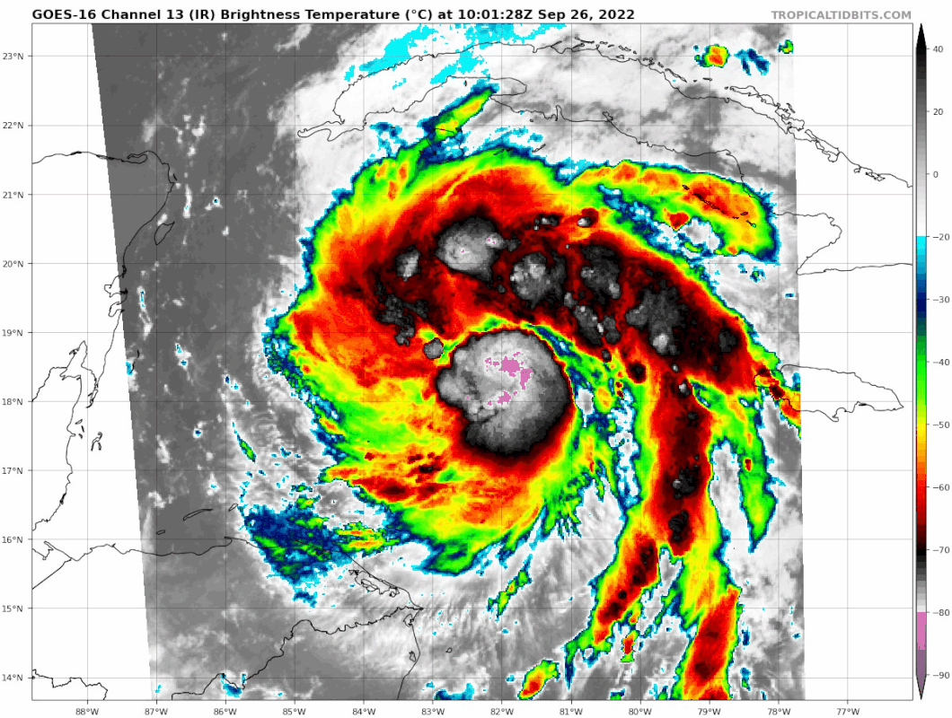
ATL: IAN - Post-Tropical - Discussion

Moderator: S2k Moderators

Message
Author
Keldeo1997
Category 2
Category 2
Posts: 637
Joined: Fri Oct 11, 2019 11:35 pm

Re: ATL: IAN - Tropical Storm - Discussion

#2041 Postby Keldeo1997 » Mon Sep 26, 2022 3:38 am

hipshot wrote:
Teban54 wrote:
cheezyWXguy wrote:Tentatively, I’m not so sure. It looks like they just missed the center, judging by the sfmr not dropping below 10kt and immediately shooting back up. I’m tempted to think it’s similar to that second pass they did on the last flight where it looked like the pressure rose. But if the next pass shows a similar pressure then I concede.

Edit: another reason the pressure may be valid is that winds in the nw quad are very unimpressive. The asymmetry of the wind field suggests Ian still has some kinks to work out

Looks like the low NW quad may be because the eyewall is open there.

The first VDM also shows a C36 eye, much larger than the 15 nm eye from the last mission.

What's a C36 eye?


Its the Size of Eye. Its 36 (now 26 after another pass) nautical miles wide.
2 likes   

User avatar
WmE
Category 2
Category 2
Posts: 696
Age: 36
Joined: Sat Jun 17, 2006 11:23 am
Location: Vienna, Austria

Re: ATL: IAN - Tropical Storm - Discussion

#2042 Postby WmE » Mon Sep 26, 2022 3:38 am

hipshot wrote:
Teban54 wrote:
cheezyWXguy wrote:Tentatively, I’m not so sure. It looks like they just missed the center, judging by the sfmr not dropping below 10kt and immediately shooting back up. I’m tempted to think it’s similar to that second pass they did on the last flight where it looked like the pressure rose. But if the next pass shows a similar pressure then I concede.

Edit: another reason the pressure may be valid is that winds in the nw quad are very unimpressive. The asymmetry of the wind field suggests Ian still has some kinks to work out

Looks like the low NW quad may be because the eyewall is open there.

The first VDM also shows a C36 eye, much larger than the 15 nm eye from the last mission.

What's a C36 eye?


Circular eye. Diameter 36 nautical miles.
2 likes   

CryHavoc
Tropical Storm
Tropical Storm
Posts: 201
Age: 43
Joined: Thu Aug 24, 2017 5:18 pm
Location: Bay Area CA

Re: ATL: IAN - Tropical Storm - Discussion

#2043 Postby CryHavoc » Mon Sep 26, 2022 3:41 am

Hurrilurker wrote:I don’t understand how they have TS watch up for south FL but no watches or warnings up for central FL. Shouldn’t there be at least a TS if not H watch for the whole FL West coast by now?


Hurricane Watch: Hurricane conditions (sustained winds of 74 mph or greater) are possible within your area. Because it may not be safe to prepare for a hurricane once winds reach tropical storm force, The NHC issues hurricane watches 48 hours before it anticipates tropical storm-force winds.

Tropical Storm Watch: Tropical storm conditions (sustained winds of 39 to 73 mph) are possible within the specified area within 48 hours.

Still probably a bit more than 48hrs out - and waiting until morning to give it more of a news push, I'm guessing? It's not due to start hitting until mid-day Wednesday for the outer bands.
2 likes   

User avatar
cycloneye
Admin
Admin
Posts: 145389
Age: 68
Joined: Thu Oct 10, 2002 10:54 am
Location: San Juan, Puerto Rico

Re: ATL: IAN - Hurricane - Discussion

#2044 Postby cycloneye » Mon Sep 26, 2022 3:58 am

Hurricane watch for Tampa, Clearwater, FT Myers.

Image
3 likes   
Visit the Caribbean-Central America Weather Thread where you can find at first post web cams,radars
and observations from Caribbean basin members Click Here

Tinman53
Tropical Wave
Tropical Wave
Posts: 4
Joined: Tue Sep 20, 2022 10:23 am

Re: ATL: IAN - Hurricane - Discussion

#2045 Postby Tinman53 » Mon Sep 26, 2022 4:00 am

Watch issued for parts of west coast of Florida shift slightly east
1 likes   

User avatar
eastcoastFL
Category 5
Category 5
Posts: 3901
Age: 43
Joined: Thu Apr 12, 2007 12:29 pm
Location: Palm City, FL

Re: ATL: IAN - Hurricane - Discussion

#2046 Postby eastcoastFL » Mon Sep 26, 2022 4:04 am

Hurricane Ian starting to look really good. Gonna be interesting when we get visible.

Image
1 likes   
Personal Forecast Disclaimer:
The posts in this forum are NOT official forecast and should not be used as such. They are just the opinion of the poster and may or may not be backed by sound meteorological data. They are NOT endorsed by any professional institution or storm2k.org. For official information, please refer to the NHC and NWS products.

User avatar
eastcoastFL
Category 5
Category 5
Posts: 3901
Age: 43
Joined: Thu Apr 12, 2007 12:29 pm
Location: Palm City, FL

Re: ATL: IAN - Hurricane - Discussion

#2047 Postby eastcoastFL » Mon Sep 26, 2022 4:05 am

Updated rain forecast from NHC through Thursday

Image
3 likes   
Personal Forecast Disclaimer:
The posts in this forum are NOT official forecast and should not be used as such. They are just the opinion of the poster and may or may not be backed by sound meteorological data. They are NOT endorsed by any professional institution or storm2k.org. For official information, please refer to the NHC and NWS products.

User avatar
kevin
Category 5
Category 5
Posts: 2586
Age: 26
Joined: Wed Aug 28, 2019 4:35 am

Re: ATL: IAN - Hurricane - Discussion

#2048 Postby kevin » Mon Sep 26, 2022 4:06 am

Another blowup of convection near the eye. I don't know about intensity, but in terms of looks I think Ian may resemble Delta when we get VIS.

2 likes   

User avatar
johngaltfla
Category 5
Category 5
Posts: 2069
Joined: Sun Jul 10, 2005 9:17 pm
Location: Sarasota County, FL
Contact:

Re: ATL: IAN - Hurricane - Discussion

#2049 Postby johngaltfla » Mon Sep 26, 2022 4:11 am

eastcoastFL wrote:Updated rain forecast from NHC through Thursday

https://www.nhc.noaa.gov/storm_graphics/AT09/refresh/AL0922WPCQPF+gif/042342WPCQPF_sm.gif


That's an underestimate if what our local mets said is correct about slowing. I could easily see 10"+ all over the Sarasota through Tampa areas if he's right about it slowing down off of our coast.

I hope everyone has a plan because it's going to be a wild week. Good luck to all of my fellow Floridians.
5 likes   

User avatar
eastcoastFL
Category 5
Category 5
Posts: 3901
Age: 43
Joined: Thu Apr 12, 2007 12:29 pm
Location: Palm City, FL

Re: ATL: IAN - Hurricane - Discussion

#2050 Postby eastcoastFL » Mon Sep 26, 2022 4:13 am

johngaltfla wrote:
eastcoastFL wrote:Updated rain forecast from NHC through Thursday

https://www.nhc.noaa.gov/storm_graphics/AT09/refresh/AL0922WPCQPF+gif/042342WPCQPF_sm.gif


That's an underestimate if what our local mets said is correct about slowing. I could easily see 10"+ all over the Sarasota through Tampa areas if he's right about it slowing down off of our coast.

I hope everyone has a plan because it's going to be a wild week. Good luck to all of my fellow Floridians.


That’s just through 8am Thursday. It’s a 3 day map. There will be much more rain beyond that as 8am Thursday it’s just offshore Tampa.
1 likes   
Personal Forecast Disclaimer:
The posts in this forum are NOT official forecast and should not be used as such. They are just the opinion of the poster and may or may not be backed by sound meteorological data. They are NOT endorsed by any professional institution or storm2k.org. For official information, please refer to the NHC and NWS products.

User avatar
eastcoastFL
Category 5
Category 5
Posts: 3901
Age: 43
Joined: Thu Apr 12, 2007 12:29 pm
Location: Palm City, FL

Re: ATL: IAN - Hurricane - Discussion

#2051 Postby eastcoastFL » Mon Sep 26, 2022 4:19 am

Eye still appears to be open on Cayman radar but the storms are sure building in nicely to its north and west

Image
1 likes   
Personal Forecast Disclaimer:
The posts in this forum are NOT official forecast and should not be used as such. They are just the opinion of the poster and may or may not be backed by sound meteorological data. They are NOT endorsed by any professional institution or storm2k.org. For official information, please refer to the NHC and NWS products.

skillz305
Category 1
Category 1
Posts: 279
Joined: Sat Sep 08, 2018 11:10 am
Location: Miami, Florida --> Vero Beach, Florida

Re: ATL: IAN - Hurricane - Discussion

#2052 Postby skillz305 » Mon Sep 26, 2022 4:31 am

Any changes to implications on east coast central Florida at this time from last night? Gotta go to work!
1 likes   
:flag:Hurricanes: Andrew 1992 - Irene 1999 - Frances 2004 - Jeanne 2004 - Katrina 2005 - Wilma 2005 - Matthew 2016 - Irma 2017 - Ian 2022 - Nicole 2022 - Milton 2024

User avatar
ObsessedMiami
Category 1
Category 1
Posts: 431
Joined: Tue Aug 31, 2004 8:08 pm
Location: West Kendall, Fl

Re: ATL: IAN - Hurricane - Discussion

#2053 Postby ObsessedMiami » Mon Sep 26, 2022 4:36 am

Given the current track or slightly right is it likely the east coast of SFL will eventually see TS watches as the system approaches?
1 likes   

User avatar
Nimbus
Category 5
Category 5
Posts: 5303
Joined: Mon Jul 19, 2004 10:54 am

Re: ATL: IAN - Hurricane - Discussion

#2054 Postby Nimbus » Mon Sep 26, 2022 4:46 am

skillz305 wrote:Any changes to implications on east coast central Florida at this time from last night? Gotta go to work!


06z GFS gives us a benchmark of -83W as it crosses the 20N latitude probably last recon mission tonight will tell..
Could easily swing north by then and its going to be a monster with surge and rain flooding of rivers on the west coast. Whether the core 100+ MPH winds make it to Tampa is still a question.
I don't think they are going to fly anything out of the space coast this week.
1 likes   

Cargill
Tropical Low
Tropical Low
Posts: 24
Age: 73
Joined: Sun Aug 26, 2012 4:45 am
Location: Melbourne Aust

Re: ATL: IAN - Hurricane - Discussion

#2055 Postby Cargill » Mon Sep 26, 2022 4:50 am

Hi - I'm an Aussie weather freak who's been a member on here for a bit more than ten years ... what I've learnt from logging on or lurking has been incredible. Australia is hugely hurricane (cyclone) prone, but because of our geography, we don't have that many people living in hurricane zones. Almost all our cyclone activity is above 20° South.

And we also seem these days to have far fewer storms per year.

I only posted to say that my name is IAN - not that common any more, in fact almost extinct. I really hope that this storm named after me fizzles into a nothing-burger before it reaches Tampa ... that would be my fondest wish.

We visited Key West (plus Miami Beach and Everglades NP) not long after Irma and Maria in October 2017. The damage visible out along the keys was extraordinary.
19 likes   

User avatar
aspen
Category 5
Category 5
Posts: 8818
Joined: Sat Oct 12, 2019 7:10 pm
Location: Connecticut, USA

Re: ATL: IAN - Hurricane - Discussion

#2056 Postby aspen » Mon Sep 26, 2022 5:20 am

It’s remarkable how quickly Ian turned itself around. 24 hours ago, it was nothing more than a cluster of tiny spotty convection.
3 likes   
Irene '11 Sandy '12 Hermine '16 5/15/2018 Derecho Fay '20 Isaias '20 Elsa '21 Henri '21 Ida '21

I am only a meteorology enthusiast who knows a decent amount about tropical cyclones. Look to the professional mets, the NHC, or your local weather office for the best information.

User avatar
kevin
Category 5
Category 5
Posts: 2586
Age: 26
Joined: Wed Aug 28, 2019 4:35 am

Re: ATL: IAN - Hurricane - Discussion

#2057 Postby kevin » Mon Sep 26, 2022 5:20 am

First recon pass, pressure down to 978.7 mb.
3 likes   

User avatar
kevin
Category 5
Category 5
Posts: 2586
Age: 26
Joined: Wed Aug 28, 2019 4:35 am

Re: ATL: IAN - Hurricane - Discussion

#2058 Postby kevin » Mon Sep 26, 2022 5:26 am

Recon fixes from the last few flights for reference. Over the last 5 hours Ian has deepened at an average rate of almost 2 mb/hr. Even if Ian just stays on its current intensification rate and doesn't RI even faster this could be enough to get it down to 940 mb before its Cuba landfall.

Sep 26
10:11z = 978.7 mb
07:18z = 983.6 mb
05:22z = 987.9 mb
00:53z = 988.5 mb

Sep 25
22:32z = 989.0 mb
10:45z = 999.4 mb
8 likes   

User avatar
aspen
Category 5
Category 5
Posts: 8818
Joined: Sat Oct 12, 2019 7:10 pm
Location: Connecticut, USA

Re: ATL: IAN - Hurricane - Discussion

#2059 Postby aspen » Mon Sep 26, 2022 5:29 am

Strange how far the max winds are from the center. In the NW quadrant, the max winds are at the very edge of the CDO. Maybe they’ll contract as Ian intensifies and the CDO organizes.
2 likes   
Irene '11 Sandy '12 Hermine '16 5/15/2018 Derecho Fay '20 Isaias '20 Elsa '21 Henri '21 Ida '21

I am only a meteorology enthusiast who knows a decent amount about tropical cyclones. Look to the professional mets, the NHC, or your local weather office for the best information.

User avatar
Teban54
Category 5
Category 5
Posts: 3208
Joined: Sat May 19, 2018 1:19 pm

Re: ATL: IAN - Hurricane - Discussion

#2060 Postby Teban54 » Mon Sep 26, 2022 5:35 am

:double:
Image
8 likes   


Return to “2022”

Who is online

Users browsing this forum: No registered users and 19 guests