ATL: IAN - Models
Moderator: S2k Moderators
-
ConvergenceZone
.gif)
- Category 5

- Posts: 5241
- Joined: Fri Jul 29, 2005 1:40 am
- Location: Northern California
Re: ATL: IAN - Models
I wouldn't pay much attention to the CMC model. It's WAY too weak in the Gulf in my opinion....
1 likes
-
SFLcane

- S2K Supporter

- Posts: 10281
- Age: 48
- Joined: Sat Jun 05, 2010 1:44 pm
- Location: Lake Worth Florida
Re: ATL: IAN - Models
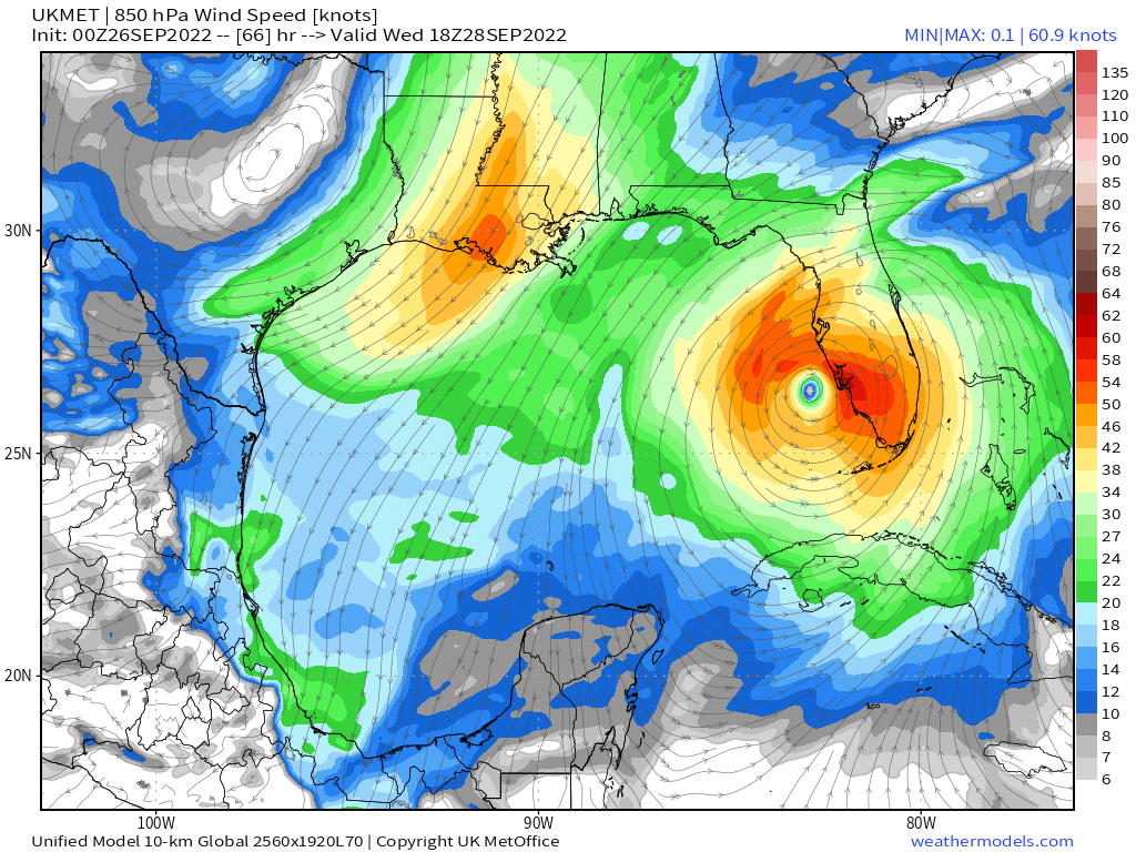
LarryWx wrote:12Z UKMET pretty close to 0Z track and continues to have a clearcut SE outlier track coming ashore well south of Tampa. Also, note that this is actually about the strongest it has had Ian (984 mb) even though it still is relatively weak vs other models. In addition, this track is SE of the 0Z track late in the run:
MET OFFICE TROPICAL CYCLONE GUIDANCE FOR NORTH-EAST PACIFIC AND ATLANTIC
GLOBAL MODEL DATA TIME 1200UTC 26.09.2022
HURRICANE IAN ANALYSED POSITION : 18.6N 82.4W
ATCF IDENTIFIER : AL092022
LEAD CENTRAL MAXIMUM WIND
VERIFYING TIME TIME POSITION PRESSURE (MB) SPEED (KNOTS)
-------------- ---- -------- ------------- -------------
1200UTC 26.09.2022 0 18.6N 82.4W 990 45
0000UTC 27.09.2022 12 20.8N 83.5W 986 48
1200UTC 27.09.2022 24 22.5N 84.0W 989 44
0000UTC 28.09.2022 36 24.0N 83.9W 986 47
1200UTC 28.09.2022 48 25.6N 83.3W 984 57
0000UTC 29.09.2022 60 26.6N 82.4W 986 52
1200UTC 29.09.2022 72 27.3N 81.7W 991 46
0000UTC 30.09.2022 84 28.3N 80.8W 992 47
1200UTC 30.09.2022 96 29.2N 80.6W 992 45
0000UTC 01.10.2022 108 30.6N 80.0W 988 50
1200UTC 01.10.2022 120 33.1N 79.9W 988 41
0000UTC 02.10.2022 132 34.9N 79.9W 997 28
1200UTC 02.10.2022 144 36.4N 78.9W 1002 29
0 likes
-
DESTRUCTION5

- Category 5
- Posts: 4430
- Age: 44
- Joined: Wed Sep 03, 2003 11:25 am
- Location: Stuart, FL
Re: ATL: IAN - Models
Ukie is either on to something or on something.
8 likes
GATOR NATION IS E V E R Y W H E R E !

Re: ATL: IAN - Models
1 likes
TC naming lists: retirements and intensity
Most aggressive Advisory #1's in North Atlantic (cr. kevin for starting the list)
Most aggressive Advisory #1's in North Atlantic (cr. kevin for starting the list)
Re: ATL: IAN - Models
SFLcane wrote:LarryWx wrote:12Z UKMET pretty close to 0Z track and continues to have a clearcut SE outlier track coming ashore well south of Tampa. Also, note that this is actually about the strongest it has had Ian (984 mb) even though it still is relatively weak vs other models. In addition, this track is SE of the 0Z track late in the run:
MET OFFICE TROPICAL CYCLONE GUIDANCE FOR NORTH-EAST PACIFIC AND ATLANTIC
GLOBAL MODEL DATA TIME 1200UTC 26.09.2022
HURRICANE IAN ANALYSED POSITION : 18.6N 82.4W
ATCF IDENTIFIER : AL092022
LEAD CENTRAL MAXIMUM WIND
VERIFYING TIME TIME POSITION PRESSURE (MB) SPEED (KNOTS)
-------------- ---- -------- ------------- -------------
1200UTC 26.09.2022 0 18.6N 82.4W 990 45
0000UTC 27.09.2022 12 20.8N 83.5W 986 48
1200UTC 27.09.2022 24 22.5N 84.0W 989 44
0000UTC 28.09.2022 36 24.0N 83.9W 986 47
1200UTC 28.09.2022 48 25.6N 83.3W 984 57
0000UTC 29.09.2022 60 26.6N 82.4W 986 52
1200UTC 29.09.2022 72 27.3N 81.7W 991 46
0000UTC 30.09.2022 84 28.3N 80.8W 992 47
1200UTC 30.09.2022 96 29.2N 80.6W 992 45
0000UTC 01.10.2022 108 30.6N 80.0W 988 50
1200UTC 01.10.2022 120 33.1N 79.9W 988 41
0000UTC 02.10.2022 132 34.9N 79.9W 997 28
1200UTC 02.10.2022 144 36.4N 78.9W 1002 29
https://i.postimg.cc/nLNqVj7s/ukmet.png
12Z UKMET landfalls in Port Charlotte area, about 75 miles south of Tampa area, perhaps barely south of the 0Zrun.
1 likes
Personal Forecast Disclaimer:
The posts in this forum are NOT official forecasts and should not be used as such. They are just the opinion of the poster and may or may not be backed by sound meteorological data. They are NOT endorsed by any professional institution or storm2k.org. For official information, please refer to the NHC and NWS products.
The posts in this forum are NOT official forecasts and should not be used as such. They are just the opinion of the poster and may or may not be backed by sound meteorological data. They are NOT endorsed by any professional institution or storm2k.org. For official information, please refer to the NHC and NWS products.
-
AutoPenalti
- Category 5
- Posts: 4091
- Age: 29
- Joined: Mon Aug 17, 2015 4:16 pm
- Location: Ft. Lauderdale, Florida
Re: ATL: IAN - Models
SFLcane wrote:LarryWx wrote:12Z UKMET pretty close to 0Z track and continues to have a clearcut SE outlier track coming ashore well south of Tampa. Also, note that this is actually about the strongest it has had Ian (984 mb) even though it still is relatively weak vs other models. In addition, this track is SE of the 0Z track late in the run:
MET OFFICE TROPICAL CYCLONE GUIDANCE FOR NORTH-EAST PACIFIC AND ATLANTIC
GLOBAL MODEL DATA TIME 1200UTC 26.09.2022
HURRICANE IAN ANALYSED POSITION : 18.6N 82.4W
ATCF IDENTIFIER : AL092022
LEAD CENTRAL MAXIMUM WIND
VERIFYING TIME TIME POSITION PRESSURE (MB) SPEED (KNOTS)
-------------- ---- -------- ------------- -------------
1200UTC 26.09.2022 0 18.6N 82.4W 990 45
0000UTC 27.09.2022 12 20.8N 83.5W 986 48
1200UTC 27.09.2022 24 22.5N 84.0W 989 44
0000UTC 28.09.2022 36 24.0N 83.9W 986 47
1200UTC 28.09.2022 48 25.6N 83.3W 984 57
0000UTC 29.09.2022 60 26.6N 82.4W 986 52
1200UTC 29.09.2022 72 27.3N 81.7W 991 46
0000UTC 30.09.2022 84 28.3N 80.8W 992 47
1200UTC 30.09.2022 96 29.2N 80.6W 992 45
0000UTC 01.10.2022 108 30.6N 80.0W 988 50
1200UTC 01.10.2022 120 33.1N 79.9W 988 41
0000UTC 02.10.2022 132 34.9N 79.9W 997 28
1200UTC 02.10.2022 144 36.4N 78.9W 1002 29
https://i.postimg.cc/nLNqVj7s/ukmet.png
That image is 0z.
1 likes
The posts in this forum are NOT official forecasts and should not be used as such. They are just the opinion of the poster and may or may not be backed by sound meteorological data. They are NOT endorsed by any professional institution or STORM2K. For official information, please refer to products from the NHC and NWS.
Model Runs Cheat Sheet:
GFS (5:30 AM/PM, 11:30 AM/PM)
HWRF, GFDL, UKMET, NAVGEM (6:30-8:00 AM/PM, 12:30-2:00 AM/PM)
ECMWF (1:45 AM/PM)
TCVN is a weighted averaged
Re: ATL: IAN - Models
tolakram wrote:You really have to hate all these models. I thought I ran the Canadian here by accident, this is the Euro.
https://i.imgur.com/6n97jNI.gif
Ermagerd, it ends there?!? . . . Where is that going after this left turn shown at the end? The HWRF 6z run suggests a little meandering followed by Panama City, but at this point I don't think anything can be applied between models insofar as logic is concerned.
By the way, "windshield wiper" as a loving insult to the models still works, but I feel like any minute now we're going to go full Radar Sweep:

3 likes
Baton Rouge area cyclone dilettante, PSWAGGER* tropical weather & hydrology model developer
(* Pseudo-Scientific Wild-A** Guesses Generally Expressed Ridiculously)
The GFDL would've had all this figured out by now.
(* Pseudo-Scientific Wild-A** Guesses Generally Expressed Ridiculously)
The GFDL would've had all this figured out by now.
Re: ATL: IAN - Models
Thanks. This shows the 12Z UK hitting Port Charlotte area and also look at what it does in SC. It has a landfall near Charleston.
1 likes
Personal Forecast Disclaimer:
The posts in this forum are NOT official forecasts and should not be used as such. They are just the opinion of the poster and may or may not be backed by sound meteorological data. They are NOT endorsed by any professional institution or storm2k.org. For official information, please refer to the NHC and NWS products.
The posts in this forum are NOT official forecasts and should not be used as such. They are just the opinion of the poster and may or may not be backed by sound meteorological data. They are NOT endorsed by any professional institution or storm2k.org. For official information, please refer to the NHC and NWS products.
Re: ATL: IAN - Models
tolakram wrote:One of these is going to be wrong in just over 30 hours.
HWRF
https://i.imgur.com/iVzIDUS.gif
HAFS
https://i.imgur.com/LastwTu.gif
Aren’t those the 6Z, not 12Z
1 likes
-
eastcoastFL

- Category 5
- Posts: 3996
- Age: 44
- Joined: Thu Apr 12, 2007 12:29 pm
- Location: Palm City, FL
Re: ATL: IAN - Models
skyline385 wrote:tolakram wrote:One of these is going to be wrong in just over 30 hours.
HWRF
https://i.imgur.com/iVzIDUS.gif
HAFS
https://i.imgur.com/LastwTu.gif
06Z HMON has the same landfall as the HAFS run which carries more weight in my opinion because it isn’t experimental
Sent from my iPhone using Tapatalk
Is that right into the bay? Or slightly north of it?
1 likes
Personal Forecast Disclaimer:
The posts in this forum are NOT official forecast and should not be used as such. They are just the opinion of the poster and may or may not be backed by sound meteorological data. They are NOT endorsed by any professional institution or storm2k.org. For official information, please refer to the NHC and NWS products.
The posts in this forum are NOT official forecast and should not be used as such. They are just the opinion of the poster and may or may not be backed by sound meteorological data. They are NOT endorsed by any professional institution or storm2k.org. For official information, please refer to the NHC and NWS products.
-
AerospaceEng
- Tropical Depression

- Posts: 53
- Joined: Mon Mar 07, 2016 10:34 am

Re: ATL: IAN - Models
Thank you for this great animation. What's really bizarre is that the UKMET is often on the left side of guidance. For example, it was about the best with Irma and that is because it was on the left side.
If this were to end up verifying closely, it would be great news for Tampa though bad in the Port Charlotte to Ft Myers area.
1 likes
Personal Forecast Disclaimer:
The posts in this forum are NOT official forecasts and should not be used as such. They are just the opinion of the poster and may or may not be backed by sound meteorological data. They are NOT endorsed by any professional institution or storm2k.org. For official information, please refer to the NHC and NWS products.
The posts in this forum are NOT official forecasts and should not be used as such. They are just the opinion of the poster and may or may not be backed by sound meteorological data. They are NOT endorsed by any professional institution or storm2k.org. For official information, please refer to the NHC and NWS products.
-
TheHurricaneGod
- Tropical Storm

- Posts: 165
- Age: 23
- Joined: Thu Apr 16, 2020 6:19 pm
- Location: Fort Lauderdale
Re: ATL: IAN - Models
What's different on the 12z UKMET that causes it to be so far south vs the other models?
2 likes
Re: ATL: IAN - Models
12Z JMA landfalls at Sarasota, barely south of Tampa.
1 likes
Personal Forecast Disclaimer:
The posts in this forum are NOT official forecasts and should not be used as such. They are just the opinion of the poster and may or may not be backed by sound meteorological data. They are NOT endorsed by any professional institution or storm2k.org. For official information, please refer to the NHC and NWS products.
The posts in this forum are NOT official forecasts and should not be used as such. They are just the opinion of the poster and may or may not be backed by sound meteorological data. They are NOT endorsed by any professional institution or storm2k.org. For official information, please refer to the NHC and NWS products.
Re: ATL: IAN - Models
Just like I feared, the HMON model has another devastating hit for Tampa, now we just wait for the HWRF to finish and see what it does.
1 likes
-
AutoPenalti
- Category 5
- Posts: 4091
- Age: 29
- Joined: Mon Aug 17, 2015 4:16 pm
- Location: Ft. Lauderdale, Florida
Re: ATL: IAN - Models
Yikes, now all models are zeroing in on Tampa or just around it, did new data come in?
5 likes
The posts in this forum are NOT official forecasts and should not be used as such. They are just the opinion of the poster and may or may not be backed by sound meteorological data. They are NOT endorsed by any professional institution or STORM2K. For official information, please refer to products from the NHC and NWS.
Model Runs Cheat Sheet:
GFS (5:30 AM/PM, 11:30 AM/PM)
HWRF, GFDL, UKMET, NAVGEM (6:30-8:00 AM/PM, 12:30-2:00 AM/PM)
ECMWF (1:45 AM/PM)
TCVN is a weighted averaged
-
Ivanhater

- Storm2k Moderator

- Posts: 11221
- Age: 39
- Joined: Fri Jul 01, 2005 8:25 am
- Location: Pensacola
Re: ATL: IAN - Models
12Z Gfs ensembles well west into panhandle matching up with latest Euro and Euro ensembles
2 likes
Michael
-
StormPyrate
- Category 1

- Posts: 286
- Joined: Sun May 27, 2018 8:41 pm
- Location: Clearwater, FL
Re: ATL: IAN - Models
Ivanhater wrote:12Z Gfs ensembles well west into panhandle matching up with latest Euro and Euro ensembles
If you could, why the disparity in the ensembles vs track
2 likes
St Petersburg Florida
Who is online
Users browsing this forum: No registered users and 26 guests