ATL: IAN - Post-Tropical - Discussion
Moderator: S2k Moderators
-
cheezyWXguy

- Category 5

- Posts: 6282
- Joined: Mon Feb 13, 2006 12:29 am
- Location: Dallas, TX
Re: ATL: IAN - Hurricane - Discussion
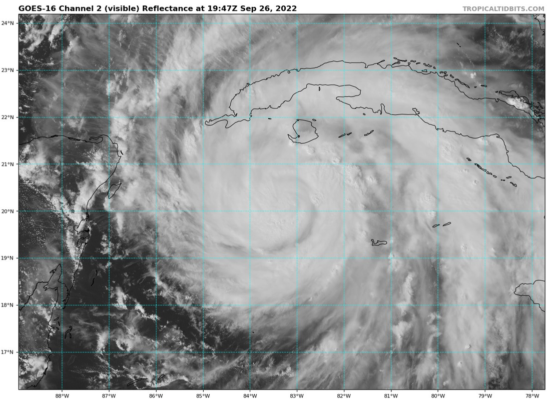
Eye is becoming visible in the ne portion of the cdo. This attempt at clearing should be successful
0 likes
-
Ed_2001

- Tropical Storm

- Posts: 246
- Age: 24
- Joined: Wed Jun 21, 2017 11:39 pm
- Location: Santa Barbara, CA>>Tampa, FL
Re: ATL: IAN - Hurricane - Discussion
Iceresistance wrote:Looking at IR, is it just me, or did Ian take a big jog to the west?
Looks like it’s only convections blowing up in the westward direction creating an illusion.
1 likes
The answer my friend, is blowing in the wind...
Re: ATL: IAN - Hurricane - Discussion
I am so happy to see that the gang is all here! Thank you for helping us all to make informed decisions about what to do to take care of ourselves during this uncertain time. 
14 likes
-
skillz305
- Category 1

- Posts: 312
- Joined: Sat Sep 08, 2018 11:10 am
- Location: Miami, Florida --> Vero Beach, Florida
Re: ATL: IAN - Hurricane - Discussion
Orlando wrote:I am so happy to see that the gang is all here! Thank you for helping us all to make informed decisions about what to do to take care of ourselves during this uncertain time.
Facts. Thanks to all the pro Mets in here who give clearance to lots of things (and others as well who are very knowledgeable)
2 likes
 Hurricanes: Andrew 1992 - Irene 1999 - Frances 2004 - Jeanne 2004 - Katrina 2005 - Wilma 2005 - Matthew 2016 - Irma 2017 - Ian 2022 - Nicole 2022 - Milton 2024
Re: ATL: IAN - Hurricane - Discussion
12Z EPS mean not surprisingly east of 6Z and similar to 0Z with a mean track near Tampa.
2 likes
Personal Forecast Disclaimer:
The posts in this forum are NOT official forecasts and should not be used as such. They are just the opinion of the poster and may or may not be backed by sound meteorological data. They are NOT endorsed by any professional institution or storm2k.org. For official information, please refer to the NHC and NWS products.
The posts in this forum are NOT official forecasts and should not be used as such. They are just the opinion of the poster and may or may not be backed by sound meteorological data. They are NOT endorsed by any professional institution or storm2k.org. For official information, please refer to the NHC and NWS products.
-
Aric Dunn
- Category 5
- Posts: 21238
- Age: 43
- Joined: Sun Sep 19, 2004 9:58 pm
- Location: Ready for the Chase.
- Contact:
Re: ATL: IAN - Hurricane - Discussion
radar and sat def show WNW to NW short term motion while it has been deepening( normal cyclonic loops). NW/NNW show resume though. looks like it will pass west of the forecast point and probably just go over the very tip of Cuba. Pretty flat and narrow. wont cause much of any issues for it.
2 likes
Note: If I make a post that is brief. Please refer back to previous posts for the analysis or reasoning. I do not re-write/qoute what my initial post said each time.
If there is nothing before... then just ask
Space & Atmospheric Physicist, Embry-Riddle Aeronautical University,
I believe the sky is falling...
If there is nothing before... then just ask
Space & Atmospheric Physicist, Embry-Riddle Aeronautical University,
I believe the sky is falling...

Re: ATL: IAN - Hurricane - Discussion
0 likes
TC naming lists: retirements and intensity
Most aggressive Advisory #1's in North Atlantic (cr. kevin for starting the list)
Most aggressive Advisory #1's in North Atlantic (cr. kevin for starting the list)
-
Hurricane Mike
- Category 2

- Posts: 675
- Joined: Tue Apr 10, 2018 7:44 am
-
ScottNAtlanta

- Category 5
- Posts: 2535
- Joined: Sat May 25, 2013 3:11 pm
- Location: Atlanta, GA
Re: ATL: IAN - Hurricane - Discussion
Hurricane Mike wrote:https://twitter.com/IPRTropicUpdate/status/1574483673398878213/photo/1
Lilly also fell apart as it headed north into the GOM following Isidore's cold wake right before landfall (it was a cat 4 before that)
3 likes
The posts in this forum are NOT official forecast and should not be used as such. They are just the opinion of the poster and may or may not be backed by sound meteorological data. They are NOT endorsed by any professional institution or storm2k.org. For official information, please refer to the NHC and NWS products.
-
skyline385

- Category 5
- Posts: 2728
- Age: 35
- Joined: Wed Aug 26, 2020 11:15 pm
- Location: Houston TX


Re: ATL: IAN - Hurricane - Discussion
Hey i’m 50 miles north of tampa near coast with mandatory evac effective 9am tomorrow. does that mean i have to leave by 9 or can i wait longer as long as it’s not too late. like afternoon sometime. i’m not sure how the law applies
0 likes
Robbielyn McCrary
I know just about enough to sound like I know what I'm talking about sometimes. But for your safety please follow the nhc for truly professional forecasting.
I know just about enough to sound like I know what I'm talking about sometimes. But for your safety please follow the nhc for truly professional forecasting.
-
p1nheadlarry

- Category 2
- Posts: 672
- Age: 34
- Joined: Wed Jan 29, 2014 2:42 pm
- Location: SR County FL
Re: ATL: IAN - Hurricane - Discussion
robbielyn wrote:Hey i’m 50 miles north of tampa near coast with mandatory evac effective 9am tomorrow. does that mean i have to leave by 9 or can i wait longer as long as it’s not too late. like afternoon sometime. i’m not sure how the law applies
Basically means if you don't evacuate emergency personnel are not going to put their lives in danger to help you when it hits the fan
Last edited by p1nheadlarry on Mon Sep 26, 2022 3:08 pm, edited 1 time in total.
2 likes
--;->#GoNoles--;->.

Re: ATL: IAN - Hurricane - Discussion
I’m starting to become skeptical this surpasses Cat 2 intensity. Its current structure is just all over the place. First it had a regular eyewall, then it broke, then it became big, then a smaller one formed. I can’t tell where the center are true dominant eyewall are supposed to be on visible. This extremely complicated and fluctuating structure should prevent much more intensification until it eventually settles down, if it ever does.
Edit: didn’t see the microwave pass before.
Edit: didn’t see the microwave pass before.
Last edited by aspen on Mon Sep 26, 2022 3:09 pm, edited 1 time in total.
1 likes
Irene '11 Sandy '12 Hermine '16 5/15/2018 Derecho Fay '20 Isaias '20 Elsa '21 Henri '21 Ida '21
I am only a meteorology enthusiast who knows a decent amount about tropical cyclones. Look to the professional mets, the NHC, or your local weather office for the best information.
I am only a meteorology enthusiast who knows a decent amount about tropical cyclones. Look to the professional mets, the NHC, or your local weather office for the best information.
Re: ATL: IAN - Hurricane - Discussion
robbielyn wrote:Hey i’m 50 miles north of tampa near coast with mandatory evac effective 9am tomorrow. does that mean i have to leave by 9 or can i wait longer as long as it’s not too late. like afternoon sometime. i’m not sure how the law applies
If evacuations are ordered for 9 am I would leave by 9 pm tonight.
7 likes
// Opinions are my own, I am not a Meteorologist. Consult the NHC or Local NWS and Emergency Management for current information in your area. //
-
p1nheadlarry
- Category 2
- Posts: 672
- Age: 34
- Joined: Wed Jan 29, 2014 2:42 pm
- Location: SR County FL
Re: ATL: IAN - Hurricane - Discussion
aspen wrote:I’m starting to become skeptical this surpasses Cat 2 intensity. Its current structure is just all over the place. First it had a regular eyewall, then it broke, then it became big, then a smaller one formed. I can’t tell where the center are true dominant eyewall are supposed to be on visible. This extremely complicated and fluctuating structure should prevent much more intensification until it eventually settles down, if it ever does.
I don't think it's that far off from intensifying tbh, environment still favorable after Cuba landfall
0 likes
--;->#GoNoles--;->.

Re: ATL: IAN - Hurricane - Discussion
robbielyn wrote:Hey i’m 50 miles north of tampa near coast with mandatory evac effective 9am tomorrow. does that mean i have to leave by 9 or can i wait longer as long as it’s not too late. like afternoon sometime. i’m not sure how the law applies
The longer you wait, the harder it will be to get out, from traffic, gas availability and hotel availability.
6 likes
-
Hypercane_Kyle

- Category 5
- Posts: 3465
- Joined: Sat Mar 07, 2015 7:58 pm
- Location: Cape Canaveral, FL
Re: ATL: IAN - Hurricane - Discussion
aspen wrote:I’m starting to become skeptical this surpasses Cat 2 intensity. Its current structure is just all over the place. First it had a regular eyewall, then it broke, then it became big, then a smaller one formed. I can’t tell where the center are true dominant eyewall are supposed to be on visible. This extremely complicated and fluctuating structure should prevent much more intensification until it eventually settles down, if it ever does.
Edit: didn’t see the microwave pass before.
Just part of the organization process and is on track. It has made remarkable improvements in the last 24 hours that quickly propelled it to nearly Cat 2 status.
2 likes
My posts are my own personal opinion, defer to the National Hurricane Center (NHC) and other NOAA products for decision making during hurricane season.
-
skyline385
- Category 5
- Posts: 2728
- Age: 35
- Joined: Wed Aug 26, 2020 11:15 pm
- Location: Houston TX
Re: ATL: IAN - Hurricane - Discussion
robbielyn wrote:Hey i’m 50 miles north of tampa near coast with mandatory evac effective 9am tomorrow. does that mean i have to leave by 9 or can i wait longer as long as it’s not too late. like afternoon sometime. i’m not sure how the law applies
Should be leaving early, you don’t want to be stuck on the road with no gas
Sent from my iPhone using Tapatalk
1 likes
Re: ATL: IAN - Hurricane - Discussion
aspen wrote:I’m starting to become skeptical this surpasses Cat 2 intensity. Its current structure is just all over the place. First it had a regular eyewall, then it broke, then it became big, then a smaller one formed. I can’t tell where the center are true dominant eyewall are supposed to be on visible. This extremely complicated and fluctuating structure should prevent much more intensification until it eventually settles down, if it ever does.
Edit: didn’t see the microwave pass before.
you could be on to something. nhc disagrees, we'll see who is right....
0 likes
Re: ATL: IAN - Hurricane - Discussion
p1nheadlarry wrote:robbielyn wrote:Hey i’m 50 miles north of tampa near coast with mandatory evac effective 9am tomorrow. does that mean i have to leave by 9 or can i wait longer as long as it’s not too late. like afternoon sometime. i’m not sure how the law applies
Basically means if you don't evacuate emergency personnel are not going to put their lives in danger to help you when it hits the fan
I won’t wait till it’s too late. my friend telling me i need to leave at 9 and there will be no weather yet so i’m like wait a few hours. i will obey the law but not sure if i hv to leave at 9
0 likes
Robbielyn McCrary
I know just about enough to sound like I know what I'm talking about sometimes. But for your safety please follow the nhc for truly professional forecasting.
I know just about enough to sound like I know what I'm talking about sometimes. But for your safety please follow the nhc for truly professional forecasting.
Who is online
Users browsing this forum: No registered users and 8 guests