
ATL: IAN - Models
Moderator: S2k Moderators
Re: ATL: IAN - Models
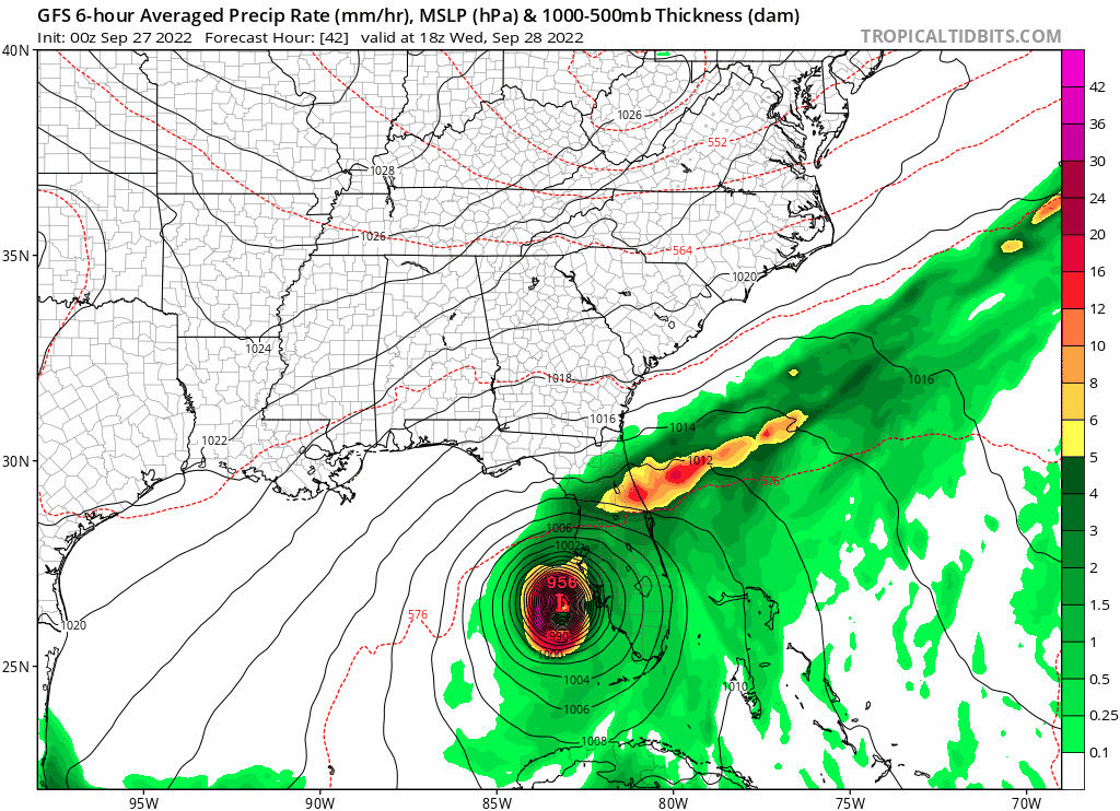
0z GFS 42-96 hrs
1 likes
TC naming lists: retirements and intensity
Most aggressive Advisory #1's in North Atlantic (cr. kevin for starting the list)
Most aggressive Advisory #1's in North Atlantic (cr. kevin for starting the list)

Re: ATL: IAN - Models
Landfall over Sarasota county will be orders of magnitude better on the Tampa bay surge issue. But with the strong northwest eye wall side could still wallop st. Pete and Tampa. It won’t make tons of difference to Sarasota, but will help Tampa a lot.
4 likes
-
Craters
- Category 1

- Posts: 428
- Joined: Sat Aug 24, 2013 2:34 pm
- Location: Alvin, TX (south of Houston)
Re: ATL: IAN - Models
Meteorcane wrote:With this GFS solution the Tampa area would trade the surge for prodigious rainfall (as precipitation becomes displaced to the north as the system is sheared), swath of 30-45 inch totals.
https://m1o.pivotalweather.com/maps/models/gfs/2022092700/081/qpf_acc.us_se.png
That looks like 33" - 35" to me, but even so, I wouldn't wish that on anybody, having gone through Harvey.
6 likes
Nothing that I post here should ever be treated as a forecast or anything resembling one. Please check with your local NWS office or the NHC for forecasts, watches, and warnings.

Re: ATL: IAN - Models
I don't know what would be worst north of Tampa Bay, a storm surge or 40"+ of rain if Ian stall to the south.

5 likes
Re: ATL: IAN - Models
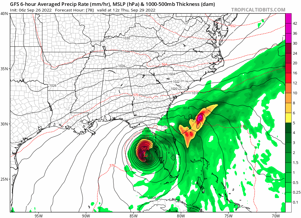
GFS trend
1 likes
TC naming lists: retirements and intensity
Most aggressive Advisory #1's in North Atlantic (cr. kevin for starting the list)
Most aggressive Advisory #1's in North Atlantic (cr. kevin for starting the list)
-
tolakram
- Admin

- Posts: 20186
- Age: 62
- Joined: Sun Aug 27, 2006 8:23 pm
- Location: Florence, KY (name is Mark)
Re: ATL: IAN - Models

2 likes
M a r k
- - - - -
Join us in chat: Storm2K Chatroom Invite. Android and IOS apps also available.
The posts in this forum are NOT official forecasts and should not be used as such. Posts are NOT endorsed by any professional institution or STORM2K.org. For official information and forecasts, please refer to NHC and NWS products.
-
gatorcane

- S2K Supporter

- Posts: 23708
- Age: 48
- Joined: Sun Mar 13, 2005 3:54 pm
- Location: Boca Raton, FL
Re: ATL: IAN - Models
NDG wrote:I don't know what would be worst north of Tampa Bay, a storm surge or 40"+ of rain if Ian stall to the south.
https://i.imgur.com/hyBRE5i.png
Wow 42 inches of rain for Pinellas. Is that realistic?
Last edited by gatorcane on Mon Sep 26, 2022 11:07 pm, edited 1 time in total.
4 likes
-
Meteorcane

- Category 2

- Posts: 559
- Joined: Thu Jul 21, 2011 6:49 am
- Location: North Platte Nebraska
Re: ATL: IAN - Models
00Z CMC is over 100 miles east of its 12Z run through about 54 hours... still the slowest moving solution so it will likely stall just offshore of Tampa and drift slowly northward.
Last edited by Meteorcane on Mon Sep 26, 2022 11:09 pm, edited 1 time in total.
4 likes
-
tolakram
- Admin
- Posts: 20186
- Age: 62
- Joined: Sun Aug 27, 2006 8:23 pm
- Location: Florence, KY (name is Mark)
Re: ATL: IAN - Models

2 likes
M a r k
- - - - -
Join us in chat: Storm2K Chatroom Invite. Android and IOS apps also available.
The posts in this forum are NOT official forecasts and should not be used as such. Posts are NOT endorsed by any professional institution or STORM2K.org. For official information and forecasts, please refer to NHC and NWS products.
- - - - -
Join us in chat: Storm2K Chatroom Invite. Android and IOS apps also available.
The posts in this forum are NOT official forecasts and should not be used as such. Posts are NOT endorsed by any professional institution or STORM2K.org. For official information and forecasts, please refer to NHC and NWS products.
-
eastcoastFL

- Category 5

- Posts: 3996
- Age: 44
- Joined: Thu Apr 12, 2007 12:29 pm
- Location: Palm City, FL
Re: ATL: IAN - Models
This would be absolutely horrific not to mention insane. This is like Harvey on the west coast of Florida.
6 likes
Personal Forecast Disclaimer:
The posts in this forum are NOT official forecast and should not be used as such. They are just the opinion of the poster and may or may not be backed by sound meteorological data. They are NOT endorsed by any professional institution or storm2k.org. For official information, please refer to the NHC and NWS products.
The posts in this forum are NOT official forecast and should not be used as such. They are just the opinion of the poster and may or may not be backed by sound meteorological data. They are NOT endorsed by any professional institution or storm2k.org. For official information, please refer to the NHC and NWS products.

Re: ATL: IAN - Models
Craters wrote:Meteorcane wrote:With this GFS solution the Tampa area would trade the surge for prodigious rainfall (as precipitation becomes displaced to the north as the system is sheared), swath of 30-45 inch totals.
https://m1o.pivotalweather.com/maps/models/gfs/2022092700/081/qpf_acc.us_se.png
That looks like 33" - 35" to me, but even so, I wouldn't wish that on anybody, having gone through Harvey.
Let's not forget the ground is already saturated in the Tampa Bay area.
4 likes
-
cheezyWXguy

- Category 5
- Posts: 6282
- Joined: Mon Feb 13, 2006 12:29 am
- Location: Dallas, TX
Re: ATL: IAN - Models
Positive trends so far, but tampa is by no means out of the woods yet in regard to surge. I’m hesitant to lean into a further south landfall, not only because of the impacts of small deviations/wobbles, but also because a stronger storm will have a tendency to try and stay a little west of the path. It bothers me that both the icon and gfs initialized too weak and still bring this as close as they do to Tampa
Last edited by cheezyWXguy on Mon Sep 26, 2022 11:10 pm, edited 1 time in total.
2 likes


Re: ATL: IAN - Models
tolakram wrote:https://i.imgur.com/B2yISb5.png
I'm going to need to break out the flippers if that kind of rainfall comes to pass.
4 likes
Re: ATL: IAN - Models
tolakram wrote:https://i.imgur.com/B2yISb5.png
Wow. I live in the 42 inch swath. Hope that doesn't bear out. Thats biblical stuff
2 likes

Re: ATL: IAN - Models
tolakram wrote:https://i.imgur.com/B2yISb5.png
Central Florida Kayak Navy officer, reporting for duty
7 likes
Andy D
(For official information, please refer to the NHC and NWS products.)
(For official information, please refer to the NHC and NWS products.)
-
eastcoastFL
- Category 5
- Posts: 3996
- Age: 44
- Joined: Thu Apr 12, 2007 12:29 pm
- Location: Palm City, FL
Re: ATL: IAN - Models
cheezyWXguy wrote:Positive trends so far, but tampa is by no means out of the woods yet in regard to surge. I’m hesitant to lean into a further south landfall, not only because of the impacts of small deviations/wobbles, but also because a stronger storm will have a tendency to try and stay a little west of the path. It bothers me that both the icon and gfs initialized too weak and still bring this as close as they do to Tampa
What is positive about the trend, is it the decreased surge threat?
4 likes
Personal Forecast Disclaimer:
The posts in this forum are NOT official forecast and should not be used as such. They are just the opinion of the poster and may or may not be backed by sound meteorological data. They are NOT endorsed by any professional institution or storm2k.org. For official information, please refer to the NHC and NWS products.
The posts in this forum are NOT official forecast and should not be used as such. They are just the opinion of the poster and may or may not be backed by sound meteorological data. They are NOT endorsed by any professional institution or storm2k.org. For official information, please refer to the NHC and NWS products.
-
AdamFirst

- S2K Supporter
- Posts: 2490
- Age: 36
- Joined: Thu Aug 14, 2008 10:54 am
- Location: Port Saint Lucie, FL
Re: ATL: IAN - Models
anyone have the UKM plot? They've consistently been on the southern end of the envelope and I'd like to see where that one ends up.
2 likes
Dolphins Marlins Canes Golden Panthers HEAT
Andrew 1992 - Irene 1999 - Frances 2004 - Jeanne 2004 - Wilma 2005 - Fay 2008 - Isaac 2012 - Matthew 2016 - Irma 2017 - Dorian 2019 - Ian 2022 - Nicole 2022 - Milton 2024
Andrew 1992 - Irene 1999 - Frances 2004 - Jeanne 2004 - Wilma 2005 - Fay 2008 - Isaac 2012 - Matthew 2016 - Irma 2017 - Dorian 2019 - Ian 2022 - Nicole 2022 - Milton 2024
-
cheezyWXguy
- Category 5
- Posts: 6282
- Joined: Mon Feb 13, 2006 12:29 am
- Location: Dallas, TX
Re: ATL: IAN - Models
eastcoastFL wrote:cheezyWXguy wrote:Positive trends so far, but tampa is by no means out of the woods yet in regard to surge. I’m hesitant to lean into a further south landfall, not only because of the impacts of small deviations/wobbles, but also because a stronger storm will have a tendency to try and stay a little west of the path. It bothers me that both the icon and gfs initialized too weak and still bring this as close as they do to Tampa
What is positive about the trend, is it the decreased surge threat?
Yeah the surge would be reduced to that area, and I should have pointed out that it’s a positive trend for tampa specifically. Though as others have pointed out, it’s kind of a trade off with the rain. At this point, I view any deviation from the 12z doomsday scenario as positive, even though it’s still terrible
2 likes
-
Poonwalker
- Category 1
- Posts: 270
- Joined: Tue Sep 20, 2022 11:12 am
Re: ATL: IAN - Models
Omg. Iam actually going to get flooded if that happens. Can someone verify if that’s possible?
2 likes
Re: ATL: IAN - Models
Poonwalker wrote:Omg. Iam actually going to get flooded if that happens. Can someone verify if that’s possible?
If it moves as slowly as the GFS depicts it is certainly possible. Back in 2017 I thought the rainfall numbers the models were putting out for Harvey weren’t possible unfortunately I had to learn the hard way that it was very much possible.
7 likes
Who is online
Users browsing this forum: No registered users and 17 guests