skyline385 wrote:Kinda interesting that once Ian passes, its going to be extremely dry over SFL. RH seems to be less than 20% on the GFS & Euro.
https://i.imgur.com/DBXLbhx.png
Would be a blessing if we lose power (no AC)
Moderator: S2k Moderators


skyline385 wrote:Kinda interesting that once Ian passes, its going to be extremely dry over SFL. RH seems to be less than 20% on the GFS & Euro.
https://i.imgur.com/DBXLbhx.png


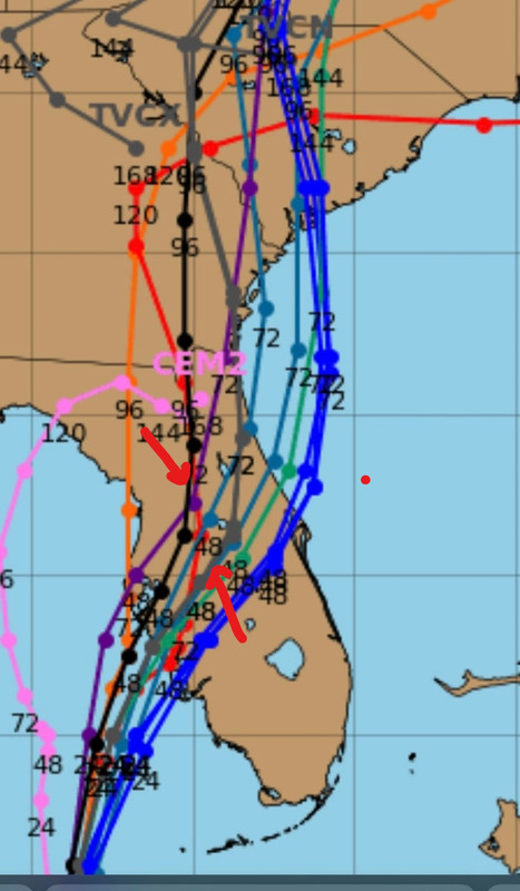
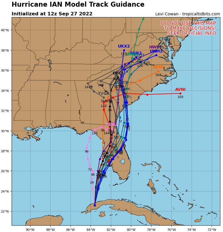
pgoss11 wrote:SFLcane wrote:Tcvn shifts east again! Now south of nhc track
https://i.postimg.cc/GmMkYWjF/B63-C7-A9-B-5-A60-45-BC-A44-E-CCAE9-ADFF6-D9.png
With these continued east shifts I think there’s more of a possibility this gets out in the Atlantic and a possible 2nd landfall in SC


caneman wrote:Seems to be the norm. A system has Tampa Bay in the bullseye for several days aka Charley and Irma and jogs to the right in the last day or two. I don't think it got far enough West to hit Tampa Bay. Once a storm starts eastward very rarely would it come back westward. PORT Charlotte- Sarasota combined with history seems a good bet. Amy further Eastward based on the last gfs frame we (pinellas county) may end up in a dry slot aka Charley. Tracking radar, a slight East of North motion seems in place.
pgoss11 wrote:With these continued east shifts I think there’s more of a possibility this gets out in the Atlantic and a possible 2nd landfall in SC
SFLcane wrote:Tcvn shifts east again!
https://i.postimg.cc/GmMkYWjF/B63-C7-A9-B-5-A60-45-BC-A44-E-CCAE9-ADFF6-D9.png

dspguy wrote:pgoss11 wrote:With these continued east shifts I think there’s more of a possibility this gets out in the Atlantic and a possible 2nd landfall in SC
What sort of intensity would one expect if Ian crosses FL and then gets out over open water before turning into SC?
tolakram wrote:6Z Euro
https://i.imgur.com/cBx1bij.gif
pgoss11 wrote:dspguy wrote:pgoss11 wrote:With these continued east shifts I think there’s more of a possibility this gets out in the Atlantic and a possible 2nd landfall in SC
What sort of intensity would one expect if Ian crosses FL and then gets out over open water before turning into SC?
That’s a hard question to answer. Much depends on the strength of Ian when he exits the peninsula and how fast the storm is moving. It’s a wait and see.
tolakram wrote:pgoss11 wrote:dspguy wrote:What sort of intensity would one expect if Ian crosses FL and then gets out over open water before turning into SC?
That’s a hard question to answer. Much depends on the strength of Ian when he exits the peninsula and how fast the storm is moving. It’s a wait and see.
No reliable model has Ian getting back into the Atlantic.
tolakram wrote:pgoss11 wrote:dspguy wrote:What sort of intensity would one expect if Ian crosses FL and then gets out over open water before turning into SC?
That’s a hard question to answer. Much depends on the strength of Ian when he exits the peninsula and how fast the storm is moving. It’s a wait and see.


Blinhart wrote:tolakram wrote:pgoss11 wrote:That’s a hard question to answer. Much depends on the strength of Ian when he exits the peninsula and how fast the storm is moving. It’s a wait and see.
No reliable model has Ian getting back into the Atlantic.
I see quite a few on the spaghetti models showing it going back into the Atlantic now.


SFLcane wrote:Official in black and grey is consensus model tcvn you can see the shift SE.
https://i.postimg.cc/HLZgxM34/ccc-jpeg.jpg
Users browsing this forum: No registered users and 49 guests


