ColdMiser123 wrote:Quite a lot of lightning in the eyewall once again.
Yeah, it really increased from an EVT that blew up in the northern eyewall.
Moderator: S2k Moderators


ColdMiser123 wrote:Quite a lot of lightning in the eyewall once again.

darc87 wrote:Some much great information here. Anyone have a projection as to how strong the storm will be when and if it reaches the center of the State? More specifically Sebring?
Sent from my Pixel 6 Pro using Tapatalk

ColdMiser123 wrote:Quite a lot of lightning in the eyewall once again.
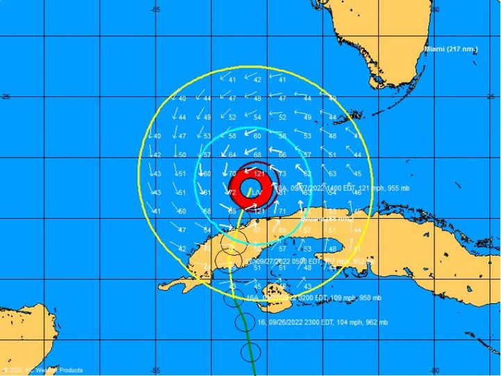
underthwx wrote:cycloneye wrote:Hurricane Ian Tropical Cyclone Update
NWS National Hurricane Center Miami FL AL092022
400 PM EDT Tue Sep 27 2022
...4 PM EDT HURRICANE IAN POSITION UPDATE...
In the past hour, the Cuba Institute of Meteorology located in
Havana reported a sustained wind of 56 mph (90 km/h) with a gust to
87 mph (140 km/h).
SUMMARY OF 400 PM EDT...2000 UTC...INFORMATION
----------------------------------------------
LOCATION...23.8N 83.2W
ABOUT 250 MI...400 KM S OF SARASOTA FLORIDA
ABOUT 65 MI...105 KM SSW OF THE DRY TORTUGAS
MAXIMUM SUSTAINED WINDS...120 MPH...195 KM/H
PRESENT MOVEMENT...N OR 10 DEGREES AT 10 MPH...17 KM/H
MINIMUM CENTRAL PRESSURE...952 MB...28.11 INCHES
$$
Forecaster Papin
56 mph sustained wind in Havana, seems like a good example of how far TS force winds are extending, not sure how far the center of Ian is from Havana.
Iceresistance wrote:underthwx wrote:cycloneye wrote:Hurricane Ian Tropical Cyclone Update
NWS National Hurricane Center Miami FL AL092022
400 PM EDT Tue Sep 27 2022
...4 PM EDT HURRICANE IAN POSITION UPDATE...
In the past hour, the Cuba Institute of Meteorology located in
Havana reported a sustained wind of 56 mph (90 km/h) with a gust to
87 mph (140 km/h).
SUMMARY OF 400 PM EDT...2000 UTC...INFORMATION
----------------------------------------------
LOCATION...23.8N 83.2W
ABOUT 250 MI...400 KM S OF SARASOTA FLORIDA
ABOUT 65 MI...105 KM SSW OF THE DRY TORTUGAS
MAXIMUM SUSTAINED WINDS...120 MPH...195 KM/H
PRESENT MOVEMENT...N OR 10 DEGREES AT 10 MPH...17 KM/H
MINIMUM CENTRAL PRESSURE...952 MB...28.11 INCHES
$$
Forecaster Papin
56 mph sustained wind in Havana, seems like a good example of how far TS force winds are extending, not sure how far the center of Ian is from Havana.
The center of Ian at the 4 PM EDT update is 70-72 miles away from Havana, Cuba

NDG wrote:What is the new AF recon doing, search & rescue?
I don't see that is doing dropsondes.
SFLcane wrote:Windfield expansion incoming!
https://twitter.com/webberweather/status/1574855290301730816s=46&t=_kObFgIiYEJHuYBxPPRU7w


Thanks. The projected path seems to have me in its sights.fci wrote:darc87 wrote:Some much great information here. Anyone have a projection as to how strong the storm will be when and if it reaches the center of the State? More specifically Sebring?
Sent from my Pixel 6 Pro using Tapatalk
With the shifts east, Sebring is under a Hurricane Watch


SFLcane wrote:Windfield expansion incoming!
https://twitter.com/webberweather/status/1574855290301730816s=46&t=_kObFgIiYEJHuYBxPPRU7w

NDG wrote:What is the new AF recon doing, search & rescue?
I don't see that is doing dropsondes.
Users browsing this forum: No registered users and 29 guests