
Didn't know there's an "ERC onset tool"
https://twitter.com/DerrickHerndon2/status/1574863725667966978
ATL: IAN - Post-Tropical - Discussion
Moderator: S2k Moderators
Re: ATL: IAN - Hurricane - Discussion
4 likes
TC naming lists: retirements and intensity
Most aggressive Advisory #1's in North Atlantic (cr. kevin for starting the list)
Most aggressive Advisory #1's in North Atlantic (cr. kevin for starting the list)
-
Blown Away

- S2K Supporter

- Posts: 10253
- Joined: Wed May 26, 2004 6:17 am
Re: ATL: IAN - Hurricane - Discussion
cheezyWXguy wrote:Wakeknight wrote:Where can I find the eye diameter?
[url]https://i.ibb.co/Jq1016G/D0-A15677-A983-499-F-9113-7430-FE566-B54.png [/url]
Cool! Amazing no hurricane warning for KW. That’s confidence!
7 likes
Hurricane Eye Experience: David 79, Irene 99, Frances 04, Jeanne 04, Wilma 05… Hurricane Brush Experience: Andrew 92, Erin 95, Floyd 99, Matthew 16, Irma 17, Ian 22, Nicole 22…
Re: ATL: IAN - Hurricane - Discussion
caneman wrote:
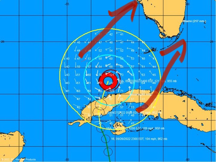
What are those arrows pointing too? That isnt the forecast track
I think he’s trying to show wide the windfield is right now
4 likes
Re: ATL: IAN - Hurricane - Discussion
NDG wrote:
Disagree, it points more towards Ft Myers if not Port Charlotte, not Naples.
Exactly!! NHC has it going to Port Charlotte. No where near those forecast points. And IF GFS and others are right, it could really slow down and ride up the West coast. Nhc talks about this possibility
Last edited by caneman on Tue Sep 27, 2022 4:15 pm, edited 1 time in total.
1 likes
Re: ATL: IAN - Hurricane - Discussion
Should be getting a center pass from the NOAA plane in about 45 minutes or so.
2 likes
-
SFLcane

- S2K Supporter
- Posts: 10281
- Age: 48
- Joined: Sat Jun 05, 2010 1:44 pm
- Location: Lake Worth Florida
Re: ATL: IAN - Hurricane - Discussion
caneman wrote:
What are those arrows pointing too? That isnt the forecast track
It’s not the forecast track obviously was just showing the windfield that is likely to get larger.
7 likes
-
THC_Scientist

- Tropical Wave

- Posts: 9
- Joined: Thu Sep 22, 2022 10:08 pm
Re: ATL: IAN - Hurricane - Discussion
Could very well be the forecast track the way things have shifted east.SFLcane wrote:caneman wrote:
What are those arrows pointing too? That isnt the forecast track
It’s not the forecast track obviously was just showing the windfield that is likely to get larger.
3 likes
Re: ATL: IAN - Hurricane - Discussion
So the NHC has continued today's track shift east (which moves the center hit south), the latest move is from north of Venice to Englewood (west of Port Charlotte).
https://www.nhc.noaa.gov/refresh/graphi ... k#contents
https://www.nhc.noaa.gov/refresh/graphi ... k#contents
3 likes
-
Iceresistance

- Category 5

- Posts: 9564
- Age: 22
- Joined: Sat Oct 10, 2020 9:45 am
- Location: Tecumseh, OK/Norman, OK
Re: ATL: IAN - Hurricane - Discussion
Another Recon plane on the way, AF306 from Biloxi, Mississippi
2 likes
Bill 2015 & Beta 2020
Winter 2020-2021
All observations are in Tecumseh, OK unless otherwise noted.
Winter posts are focused mainly for Oklahoma & Texas.
Take any of my forecasts with a grain of salt, refer to the NWS, SPC, and NHC for official information
Never say Never with weather! Because ANYTHING is possible!
Winter 2020-2021
All observations are in Tecumseh, OK unless otherwise noted.
Winter posts are focused mainly for Oklahoma & Texas.
Take any of my forecasts with a grain of salt, refer to the NWS, SPC, and NHC for official information
Never say Never with weather! Because ANYTHING is possible!
Re: ATL: IAN - Hurricane - Discussion
Just a general question about the various types of graphics available under "Lower Dynamics" on sites like Tropical Tidbits.
I see 10m wind height and 850mb wind height. A quick google search says that 850mb wind height is roughly the wind at 5000 feet. As a human that happens to live closer to 33ft (10m) as opposed to 5000 feet, when I look at those two maps and it shows wind speeds, it seems that the wind speeds for 10m height drop off really quickly after landfall. Is that actually right? I suppose the wind speeds at 5000 feet might be 80+ mph, but at ground level, is it really that much lower?
No, I'm not asking this in order to make a decision to evacuate or not (I'm not in FL). I suppose it is more idle curiosity. I've had some hurricanes skirt my area before. I'm about 25 miles inland in SC and curious what sort of wind someone would actually see at ground level from a (for example) Cat 1 coming onshore. Given what these maps are showing in Florida for Ian, it makes me wonder what sort of wind speeds someone in the middle of the state along the path would actual see at ground level.
1 likes
-
Welwood470
- Tropical Wave
- Posts: 5
- Joined: Tue Sep 03, 2019 8:35 am
Re: ATL: IAN - Hurricane - Discussion
$$
Forecaster Papin[/div][/b][/quote]
56 mph sustained wind in Havana, seems like a good example of how far TS force winds are extending from Ians center, not sure how far the center of Ian is from Havana.[/quote]
79.42 miles with 5pm NHC position.(24N 83.2W)
Forecaster Papin[/div][/b][/quote]
56 mph sustained wind in Havana, seems like a good example of how far TS force winds are extending from Ians center, not sure how far the center of Ian is from Havana.[/quote]
79.42 miles with 5pm NHC position.(24N 83.2W)
6 likes

Re: ATL: IAN - Hurricane - Discussion
Teban54 wrote:Didn't know there's an "ERC onset tool"
https://twitter.com/DerrickHerndon2/status/1574863725667966978?s=20&t=OJpn86kttjXdAIBnAHam-g
Measuring relative humidity in the eye is a good method to indicate a pending EWRC
5 likes
-
TheHurricaneGod
- Tropical Storm

- Posts: 165
- Age: 23
- Joined: Thu Apr 16, 2020 6:19 pm
- Location: Fort Lauderdale
Re: ATL: IAN - Hurricane - Discussion
dspguy wrote:Just a general question about the various types of graphics available under "Lower Dynamics" on sites like Tropical Tidbits.
I see 10m wind height and 850mb wind height. A quick google search says that 850mb wind height is roughly the wind at 5000 feet. As a human that happens to live closer to 33ft (10m) as opposed to 5000 feet, when I look at those two maps and it shows wind speeds, it seems that the wind speeds for 10m height drop off really quickly after landfall. Is that actually right? I suppose the wind speeds at 5000 feet might be 80+ mph, but at ground level, is it really that much lower?
No, I'm not asking this in order to make a decision to evacuate or not (I'm not in FL). I suppose it is more idle curiosity. I've had some hurricanes skirt my area before. I'm about 25 miles inland in SC and curious what sort of wind someone would actually see at ground level from a (for example) Cat 1 coming onshore. Given what these maps are showing in Florida for Ian, it makes me wonder what sort of wind speeds someone in the middle of the state along the path would actual see at ground level.
Surface winds usually drop really quickly due to frictional effects even just a few miles inland.
3 likes
Re: ATL: IAN - Hurricane - Discussion
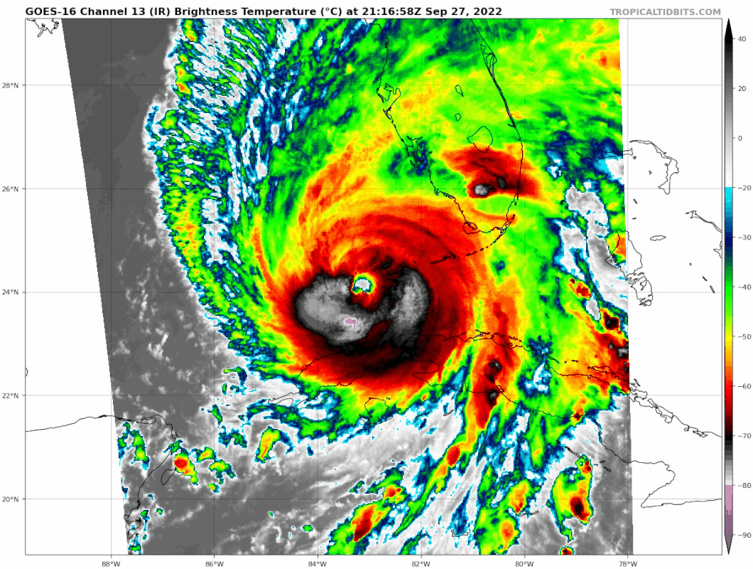
Outer eyewall really shows up on IR now.
1 likes
TC naming lists: retirements and intensity
Most aggressive Advisory #1's in North Atlantic (cr. kevin for starting the list)
Most aggressive Advisory #1's in North Atlantic (cr. kevin for starting the list)
Re: ATL: IAN - Hurricane - Discussion
5:25 ET: OBSERVED TORNADO crossing into SE Collier County, Florida.
2 likes
-
TexasBreeze
- Tropical Depression

- Posts: 81
- Joined: Mon Jul 07, 2014 12:50 pm
Re: ATL: IAN - Hurricane - Discussion
The Dry Tortugas has a lighthouse on the western most island and an old fort and visitor center on another island just to the east. Not sure about any meteorological instruments though.
2 likes
Re: ATL: IAN - Hurricane - Discussion
If you live in Trail City, Florida, it’s time to take cover! Likely a strong tornado on the ground from the outer bands of Hurricane Ian.
1 likes

Re: ATL: IAN - Hurricane - Discussion
I hope that EWRC falls apart and weakens Ian for good. It’ll further expand Ian’s wind field regardless if it completes or not, but a large Cat 1/2 is much better scenario than a large, rapidly intensifying Cat 3/4.
3 likes
Irene '11 Sandy '12 Hermine '16 5/15/2018 Derecho Fay '20 Isaias '20 Elsa '21 Henri '21 Ida '21
I am only a meteorology enthusiast who knows a decent amount about tropical cyclones. Look to the professional mets, the NHC, or your local weather office for the best information.
I am only a meteorology enthusiast who knows a decent amount about tropical cyclones. Look to the professional mets, the NHC, or your local weather office for the best information.
-
tolakram
- Admin

- Posts: 20172
- Age: 62
- Joined: Sun Aug 27, 2006 8:23 pm
- Location: Florence, KY (name is Mark)
Re: ATL: IAN - Hurricane - Discussion
For all us wobble watchers.

6 likes
M a r k
- - - - -
Join us in chat: Storm2K Chatroom Invite. Android and IOS apps also available.
The posts in this forum are NOT official forecasts and should not be used as such. Posts are NOT endorsed by any professional institution or STORM2K.org. For official information and forecasts, please refer to NHC and NWS products.
Who is online
Users browsing this forum: No registered users and 7 guests