ATL: IAN - Post-Tropical - Discussion

Moderator: S2k Moderators

Message
Author
kunosoura
S2K Supporter
S2K Supporter
Posts: 29
Joined: Thu Sep 08, 2011 11:23 am
Location: Jupiter

Re: ATL: IAN - Hurricane - Discussion

#4061 Postby kunosoura » Tue Sep 27, 2022 9:48 pm

Blown Away wrote:The rain, lighting, and gusty winds are intense tonight and hundreds of miles NE of Ian…


Yeah that was a decent set of cells that just passed through Jupiter that you now appear to be in the thick of. Stay safe.
5 likes   

User avatar
ThunderForce
Tropical Storm
Tropical Storm
Posts: 208
Age: 26
Joined: Tue Sep 27, 2022 6:20 pm
Location: Calhoun County, Florida

Re: ATL: IAN - Hurricane - Discussion

#4062 Postby ThunderForce » Tue Sep 27, 2022 9:50 pm

Jr0d wrote:
hipshot wrote:Where are you?

Key West. We are getting hammered

Please stay as safe as you can out there. I'm really worried about everyone in Ian's path right now.
5 likes   
Please refer to the NWS, NHC, SPC or a professional meteorologist for information and decision making during storms.

User avatar
Blown Away
S2K Supporter
S2K Supporter
Posts: 10152
Joined: Wed May 26, 2004 6:17 am

Re: ATL: IAN - Hurricane - Discussion

#4063 Postby Blown Away » Tue Sep 27, 2022 9:51 pm

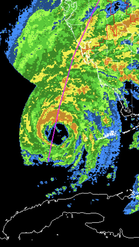
INIT 27/2100Z 24.0N 83.2W 105 KT 120 MPH
12H 28/0600Z 25.3N 82.9W 115 KT 130 MPH


10pm Ian 24.6/82.9… At NNE Ian likely to be a little R of 82.9 at the 06z time?
1 likes   
Hurricane Eye Experience: David 79, Irene 99, Frances 04, Jeanne 04, Wilma 05... EYE COMING MY WAY IN 2024…
Hurricane Brush Experience: Andrew 92, Erin 95, Floyd 99, Matthew 16, Irma 17, Ian 22, Nicole 22…

CryHavoc
Tropical Storm
Tropical Storm
Posts: 201
Age: 43
Joined: Thu Aug 24, 2017 5:18 pm
Location: Bay Area CA

Re: ATL: IAN - Hurricane - Discussion

#4064 Postby CryHavoc » Tue Sep 27, 2022 9:51 pm

Given the tornadic activity, CAPE, and the unfortunate parallel to the coastline, Ian might make a run at some tornado records for a hurricane. Not a great thing at all.
5 likes   

Kat5
Tropical Storm
Tropical Storm
Posts: 178
Joined: Tue Jul 07, 2009 5:28 pm

Re: ATL: IAN - Hurricane - Discussion

#4065 Postby Kat5 » Tue Sep 27, 2022 9:52 pm

Seems to be slowing down and turning more due N
2 likes   

User avatar
ElectricStorm
Category 5
Category 5
Posts: 5057
Age: 24
Joined: Tue Aug 13, 2019 11:23 pm
Location: Skiatook, OK / Norman, OK

Re: ATL: IAN - Hurricane - Discussion

#4066 Postby ElectricStorm » Tue Sep 27, 2022 9:54 pm

BULLETIN
Hurricane Ian Advisory Number 20
NWS National Hurricane Center Miami FL AL092022
1100 PM EDT Tue Sep 27 2022

...IAN EXPECTED TO CAUSE LIFE-THREATENING STORM SURGE, CATASTROPHIC
WINDS AND FLOODING IN THE FLORIDA PENINSULA...


SUMMARY OF 1100 PM EDT...0300 UTC...INFORMATION
-----------------------------------------------
LOCATION...24.9N 82.9W
ABOUT 110 MI...175 KM SW OF NAPLES FLORIDA
MAXIMUM SUSTAINED WINDS...120 MPH...195 KM/H
PRESENT MOVEMENT...NNE OR 15 DEGREES AT 10 MPH...17 KM/H
MINIMUM CENTRAL PRESSURE...952 MB...28.12 INCHES
1 likes   
B.S Meteorology, University of Oklahoma '25

Please refer to the NHC, NWS, or SPC for official information.

User avatar
cheezyWXguy
Category 5
Category 5
Posts: 6109
Joined: Mon Feb 13, 2006 12:29 am
Location: Dallas, TX

Re: ATL: IAN - Hurricane - Discussion

#4067 Postby cheezyWXguy » Tue Sep 27, 2022 9:54 pm

Seems to be having some trouble keeping that se eyewall closed. I wonder if these latest towers going around the bottom will fix that
1 likes   

User avatar
Blown Away
S2K Supporter
S2K Supporter
Posts: 10152
Joined: Wed May 26, 2004 6:17 am

Re: ATL: IAN - Hurricane - Discussion

#4068 Postby Blown Away » Tue Sep 27, 2022 9:57 pm

cheezyWXguy wrote:Seems to be having some trouble keeping that se eyewall closed. I wonder if these latest towers going around the bottom will fix that


Image

Thick eyewall on N side…
2 likes   
Hurricane Eye Experience: David 79, Irene 99, Frances 04, Jeanne 04, Wilma 05... EYE COMING MY WAY IN 2024…
Hurricane Brush Experience: Andrew 92, Erin 95, Floyd 99, Matthew 16, Irma 17, Ian 22, Nicole 22…

hipshot
Category 2
Category 2
Posts: 591
Joined: Tue Jul 06, 2010 9:18 pm
Location: Dallas, Texas

Re: ATL: IAN - Hurricane - Discussion

#4069 Postby hipshot » Tue Sep 27, 2022 9:57 pm

Jr0d wrote:
hipshot wrote:Where are you?

Key West. We are getting hammered


Please stay safe. A visit to Key West is on my bucket list.
4 likes   

User avatar
Teban54
Category 5
Category 5
Posts: 3208
Joined: Sat May 19, 2018 1:19 pm

Re: ATL: IAN - Hurricane - Discussion

#4070 Postby Teban54 » Tue Sep 27, 2022 9:58 pm

Food for thought:

In its last 6 hours before the Cuba landfall, Ian intensified from 90 kts to officially 110 kts (+20 kts). Many people here speculated it might have been a low-end Cat 4 (115 kts) at landfall.

Ian is now 105 kts and still has 15 hours before landfall.
4 likes   

User avatar
ElectricStorm
Category 5
Category 5
Posts: 5057
Age: 24
Joined: Tue Aug 13, 2019 11:23 pm
Location: Skiatook, OK / Norman, OK

Re: ATL: IAN - Hurricane - Discussion

#4071 Postby ElectricStorm » Tue Sep 27, 2022 10:01 pm

Updated cone
Image
7 likes   
B.S Meteorology, University of Oklahoma '25

Please refer to the NHC, NWS, or SPC for official information.

User avatar
KirbyDude25
Tropical Storm
Tropical Storm
Posts: 147
Age: 20
Joined: Mon Sep 20, 2021 8:03 am
Location: Westfield, New Jersey

Re: ATL: IAN - Hurricane - Discussion

#4072 Postby KirbyDude25 » Tue Sep 27, 2022 10:04 pm

Teban54 wrote:Food for thought:

In its last 6 hours before the Cuba landfall, Ian intensified from 90 kts to officially 110 kts (+20 kts). Many people here speculated it might have been a low-end Cat 4 (115 kts) at landfall.

Ian is now 105 kts and still has 15 hours before landfall.

I did hear about some shear and dry air, but I'm not sure how much of an effect that would have. Other than that, there's basically nothing in its way until landfall
1 likes   
New Jersey, Rutgers '27
Irene 2011 | Sandy 2012 | Fay 2020 | Isaias 2020 | Ida 2021

User avatar
Jr0d
S2K Supporter
S2K Supporter
Posts: 1409
Joined: Tue Aug 27, 2019 10:52 am
Location: Cayo Hueso

Re: ATL: IAN - Hurricane - Discussion

#4073 Postby Jr0d » Tue Sep 27, 2022 10:05 pm

Very interested to see what Key West Airport recorded with this last squall. Felt close to sustained hurricane winds for a few minutes.

These are roads, not canals.

Image

Image
15 likes   

gailwarning
S2K Supporter
S2K Supporter
Posts: 57
Joined: Sun Sep 10, 2017 1:09 pm
Location: N. Georgia. Sick of FL

Re: ATL: IAN - Hurricane - Discussion

#4074 Postby gailwarning » Tue Sep 27, 2022 10:05 pm

Jr0d wrote:
hipshot wrote:Where are you?

Key West. We are getting hammered


Hope it eases up for you soon. This is what frustrates me: just because people aren't in the direct path does NOT mean they won't get significant effects. I know the mets try to convey that, but it seems to fall on deaf ears.
7 likes   

User avatar
ThunderForce
Tropical Storm
Tropical Storm
Posts: 208
Age: 26
Joined: Tue Sep 27, 2022 6:20 pm
Location: Calhoun County, Florida

Re: ATL: IAN - Hurricane - Discussion

#4075 Postby ThunderForce » Tue Sep 27, 2022 10:06 pm

Image
It looks like Ian's moving at a snail's pace on Key West's IR radar right now. I don't see much, if any, movement.
1 likes   
Please refer to the NWS, NHC, SPC or a professional meteorologist for information and decision making during storms.

User avatar
viberama
Tropical Depression
Tropical Depression
Posts: 65
Age: 52
Joined: Mon Aug 01, 2011 7:36 pm
Location: Orlando, FL
Contact:

Re: ATL: IAN - Hurricane - Discussion

#4076 Postby viberama » Tue Sep 27, 2022 10:09 pm

ThunderForce wrote:https://i.imgur.com/QeJtLKS.gif
It looks like Ian's moving at a snail's pace on Key West's IR radar right now. I don't see much, if any, movement.


Yes, he's slowing down! Steering currents are subsiding.
3 likes   
The following post is NOT an official forecast and should not be used as such. It is just my opinion and may or may not be backed by sound meteorological data. For Official Information please refer to the NHC and NWS products

dpep4
Tropical Storm
Tropical Storm
Posts: 198
Joined: Sat Sep 09, 2017 9:04 pm

Re: ATL: IAN - Hurricane - Discussion

#4077 Postby dpep4 » Tue Sep 27, 2022 10:09 pm

NHC continues to shift the track east/south, now crossing Bokeelia and Punta Gorda. Savannah second landfall.

https://www.nhc.noaa.gov/refresh/graphi ... k#contents
Last edited by dpep4 on Tue Sep 27, 2022 10:11 pm, edited 1 time in total.
1 likes   

User avatar
FLpanhandle91
Category 5
Category 5
Posts: 1033
Age: 34
Joined: Mon Sep 13, 2010 3:50 pm
Location: Fort Walton Beach, FL

Re: ATL: IAN - Hurricane - Discussion

#4078 Postby FLpanhandle91 » Tue Sep 27, 2022 10:10 pm

That last east shift by the NHC would be absolutely devastating for Sanibel, Captiva, and Cape Coral.
4 likes   

Craters
Category 1
Category 1
Posts: 421
Joined: Sat Aug 24, 2013 2:34 pm
Location: Alvin, TX (south of Houston)

Re: ATL: IAN - Hurricane - Discussion

#4079 Postby Craters » Tue Sep 27, 2022 10:11 pm

Jr0d wrote:Im probably 60nmiles from the center. This is intense. Gusts over 70mph easily. Would not be surprised if we have had gusts to 100mph.

Seawalls are breached. Surge is becoming a major problem. A lot of flooded areas. Some roads are easily waist deep.

Hang in there, Jr0d...
4 likes   
Nothing that I post here should ever be treated as a forecast or anything resembling one. Please check with your local NWS office or the NHC for forecasts, watches, and warnings.

edu2703
Category 1
Category 1
Posts: 349
Joined: Thu Aug 23, 2018 7:15 pm

Re: ATL: IAN - Hurricane - Discussion

#4080 Postby edu2703 » Tue Sep 27, 2022 10:14 pm

ElectricStorm wrote:Updated cone
https://i.imgur.com/rZ0exae.png


I don't like seeing Ian back in the Atlantic after crossing Florida, but I assume it will be a mess and not have enough time to reorganize and re-intensify before a landfall on the east coast.
3 likes   


Return to “2022”

Who is online

Users browsing this forum: Google [Bot] and 3 guests