ATL: IAN - Post-Tropical - Discussion

Moderator: S2k Moderators

Message
Author
User avatar
TheDreamTraveler
Category 2
Category 2
Posts: 641
Joined: Sun Aug 22, 2010 3:10 am
Location: PA

Re: ATL: IAN - Hurricane - Discussion

#4521 Postby TheDreamTraveler » Wed Sep 28, 2022 7:45 am

Category5Kaiju wrote:I'm honestly flabbergasted by how many Cat 4+ storms in the Gulf have made landfall in the CONUS since 2017. Ever since then, with the exception of 2019, every year has had one of these kinds of storms, and Ian looks to continue this deadly pattern. Unlike years before then, Cat 4+ GoM storms aren't weakening before landfall, they're literally strengthening up until then. Not sure what is causing this pattern, whether it is a property of the gulf itself that has changed or if something in the Atlantic atmospheric state is causing it, but I can bet you that unless something drastic happens, it's likely that 2023, 2024, and so forth will feature at least one of these kinds of systems in their respective seasons.

It's only a matter of time before those maps depicting Harvey, Michael, Laura, Ida, and (now) Ian are going to become totally unreadable.


We went from having 0 category 3+ major hurricane landfalls in the US from 2006-2016 to so many I've lost count at this point between 2017-2022
8 likes   

User avatar
tropicwatch
Category 5
Category 5
Posts: 3389
Age: 61
Joined: Sat Jun 02, 2007 10:01 am
Location: Panama City Florida
Contact:

Re: ATL: IAN - Hurricane - Discussion

#4522 Postby tropicwatch » Wed Sep 28, 2022 7:46 am

ronjon wrote:From radar returns, looks like Ian is getting some dry air entrained on its east and southeast side. Probably the influence of the trough. Hopefully the start of a weakening trend.


Doesn't look like it is going to make it into the eyewall.

Image
5 likes   
Tropicwatch


Agnes 72', Eloise 75, Elena 85', Kate 85', Charley 86', Florence 88', Beryl 94', Dean 95', Erin 95', Opal 95', Earl 98', Georges 98', Ivan 2004', Arlene 2005', Dennis 2005', Ida 2009' Debby 2012' Irma 2017' Michael 2018'

User avatar
Hypercane_Kyle
Category 5
Category 5
Posts: 3354
Joined: Sat Mar 07, 2015 7:58 pm
Location: Cape Canaveral, FL

Re: ATL: IAN - Hurricane - Discussion

#4523 Postby Hypercane_Kyle » Wed Sep 28, 2022 7:47 am

skyline385 wrote:Is one of the recon trapped in the eye? Seems to be just doing circles and the other recon turned away at the same time. This could be getting dangerous with the continuous lighting in the eyewall.

https://i.imgur.com/sxyDfN8.png


I was wondering that. They look like they're trying to find a break in the eyewall and don't feel comfortable getting out of the calm of the eye.
3 likes   
My posts are my own personal opinion, defer to the National Hurricane Center (NHC) and other NOAA products for decision making during hurricane season.

Fancy1001
Category 1
Category 1
Posts: 452
Joined: Thu Jul 16, 2020 10:16 pm

Re: ATL: IAN - Hurricane - Discussion

#4524 Postby Fancy1001 » Wed Sep 28, 2022 7:48 am

tropicwatch wrote:
ronjon wrote:From radar returns, looks like Ian is getting some dry air entrained on its east and southeast side. Probably the influence of the trough. Hopefully the start of a weakening trend.


Doesn't look like it is going to make it into the eyewall.

https://tropicwatch.info/dryair.gif

No matter what, the eastern to south eastern section of the eye wall seems to be the weakest with Ian. I think that might be what’s preventing it from getting a little stronger right now
1 likes   

tolakram
Admin
Admin
Posts: 20012
Age: 62
Joined: Sun Aug 27, 2006 8:23 pm
Location: Florence, KY (name is Mark)

Re: ATL: IAN - Hurricane - Discussion

#4525 Postby tolakram » Wed Sep 28, 2022 7:49 am

Altitude all over the place

Image
1 likes   
M a r k
- - - - -
Join us in chat: Storm2K Chatroom Invite. Android and IOS apps also available.

The posts in this forum are NOT official forecasts and should not be used as such. Posts are NOT endorsed by any professional institution or STORM2K.org. For official information and forecasts, please refer to NHC and NWS products.

User avatar
KWT
Category 5
Category 5
Posts: 31415
Joined: Tue Aug 17, 2004 11:02 am
Location: UK!!!

Re: ATL: IAN - Hurricane - Discussion

#4526 Postby KWT » Wed Sep 28, 2022 7:50 am

Hypercane_Kyle wrote:
KWT wrote:
Hypercane_Kyle wrote:
No, I mean the entire Peninsula. The last hurricane this strong to hit FL in general was Michael in the Panhandle.


This is basically Charley's larger brother.

Ian is stronger in terms of peak, but in reality Ian and Charley in terms of max winds into SW Florida are pretty close.


Ian's overall kinetic energy is much higher than Charley. But you're right in that Charley is the closest comparison.


Even the track and timings of the strengthening is nearly identical as well, the only major difference as you rightly say is its quite alot larger of a cane than Charley, which will make its impacts almost certainly more severe.
1 likes   
Personal Forecast Disclaimer:
The posts in this forum are NOT official forecast and should not be used as such. They are just the opinion of the poster and may or may not be backed by sound meteorological data. They are NOT endorsed by any professional institution or storm2k.org. For official information, please refer to the NHC and NWS products

User avatar
Hypercane_Kyle
Category 5
Category 5
Posts: 3354
Joined: Sat Mar 07, 2015 7:58 pm
Location: Cape Canaveral, FL

Re: ATL: IAN - Hurricane - Discussion

#4527 Postby Hypercane_Kyle » Wed Sep 28, 2022 7:51 am

tolakram wrote:Altitude all over the place

https://i.imgur.com/fbfk6Hv.png


AF301 looks like they're in a tough spot. They intercepted right as the NOAA plane aborted. I don't think there's any technical issues with either plane. Ian is just that strong.
3 likes   
My posts are my own personal opinion, defer to the National Hurricane Center (NHC) and other NOAA products for decision making during hurricane season.

User avatar
cheezyWXguy
Category 5
Category 5
Posts: 6108
Joined: Mon Feb 13, 2006 12:29 am
Location: Dallas, TX

Re: ATL: IAN - Hurricane - Discussion

#4528 Postby cheezyWXguy » Wed Sep 28, 2022 7:51 am

tropicwatch wrote:
ronjon wrote:From radar returns, looks like Ian is getting some dry air entrained on its east and southeast side. Probably the influence of the trough. Hopefully the start of a weakening trend.


Doesn't look like it is going to make it into the eyewall.

https://tropicwatch.info/dryair.gif

The eastern eyewall has had intermittent gaps on radar since before midnight, doesn’t seem to be having much affect as it’s clearly intensifying… The structure it’s got here, where the thickest portion of the eyewall is the SW quad, is about as solid of a defense against SW shear as a storm can have
1 likes   

User avatar
GCANE
S2K Supporter
S2K Supporter
Posts: 11500
Joined: Mon Oct 22, 2007 8:03 am

Re: ATL: IAN - Hurricane - Discussion

#4529 Postby GCANE » Wed Sep 28, 2022 7:52 am

I never seen a TC ingest high CAPE air into its core as well as Ian.
Its like he is on an IV drip of steroids
Last edited by GCANE on Wed Sep 28, 2022 7:53 am, edited 1 time in total.
5 likes   

User avatar
stormhunter7
Category 2
Category 2
Posts: 762
Joined: Mon May 26, 2008 3:13 pm
Location: Panama City Beach, Florida
Contact:

Re: ATL: IAN - Hurricane - Discussion

#4530 Postby stormhunter7 » Wed Sep 28, 2022 7:52 am

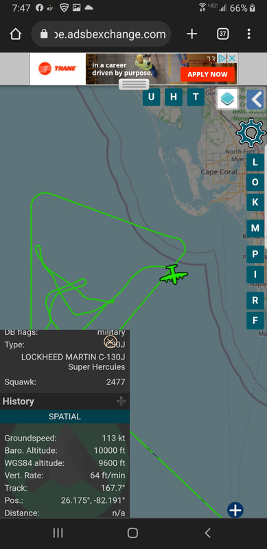
Don't think I have ever seen an C-130 into the wind at 10kft at GS of 130mph! Wow.
Image
Last edited by stormhunter7 on Wed Sep 28, 2022 7:54 am, edited 1 time in total.
3 likes   
The following post is NOT an official forecast and should not be used as such. It is just the opinion of the poster and may or may not be backed by sound meteorological data. It is NOT endorsed by any professional institution including storm2k.org For Official Information please refer to the NHC and NWS products. http://www.nhc.noaa.gov

TallyTracker
Category 2
Category 2
Posts: 734
Joined: Thu Oct 11, 2018 2:46 pm

Re: ATL: IAN - Hurricane - Discussion

#4531 Postby TallyTracker » Wed Sep 28, 2022 7:53 am

TheDreamTraveler wrote:
Category5Kaiju wrote:I'm honestly flabbergasted by how many Cat 4+ storms in the Gulf have made landfall in the CONUS since 2017. Ever since then, with the exception of 2019, every year has had one of these kinds of storms, and Ian looks to continue this deadly pattern. Unlike years before then, Cat 4+ GoM storms aren't weakening before landfall, they're literally strengthening up until then. Not sure what is causing this pattern, whether it is a property of the gulf itself that has changed or if something in the Atlantic atmospheric state is causing it, but I can bet you that unless something drastic happens, it's likely that 2023, 2024, and so forth will feature at least one of these kinds of systems in their respective seasons.

It's only a matter of time before those maps depicting Harvey, Michael, Laura, Ida, and (now) Ian are going to become totally unreadable.


We went from having 0 category 3+ major hurricane landfalls in the US from 2006-2016 to so many I've lost count at this point between 2017-2022


Historically, there seems to be years with many major hurricane strikes and then years of quiet. It’s seems we are back in the busy stretch as far as landfalls are concerned. Not sure if it’s random or if a specific cyclical weather pattern is to blame. My guess is a combination of both but that’s exactly what it is, a guess.
9 likes   
Fran '96, Georges '98, Gordon '00, Gabrielle '01, Charley '04, Frances '04, Jeanne '04, Barry '07, Fay '08, Debby '12, Matthew '16, Emily '17, Irma '17, Michael ‘18, Elsa ‘21, Fred ‘21, Mindy ‘21, Nicole ‘22, Idalia ‘23, Debby ‘24, Helene ‘24

User avatar
Category5Kaiju
Category 5
Category 5
Posts: 4103
Joined: Thu Dec 24, 2020 12:45 pm
Location: Seattle

Re: ATL: IAN - Hurricane - Discussion

#4532 Postby Category5Kaiju » Wed Sep 28, 2022 7:56 am

 https://twitter.com/islivingston/status/1436326272104288257


Soon enough, these kinds of maps will become extremely hard to read
5 likes   
Unless explicitly stated, all info in my posts is based on my own opinions and observations. Tropical storms and hurricanes can be extremely dangerous. Do not think you can beat Mother Nature. Refer to an accredited weather research agency or meteorologist if you need to make serious decisions regarding an approaching storm.

SunnyThoughts
Category 5
Category 5
Posts: 2263
Joined: Wed Jul 09, 2003 12:42 pm
Location: Pensacola, Florida

Re: ATL: IAN - Hurricane - Discussion

#4533 Postby SunnyThoughts » Wed Sep 28, 2022 7:57 am

Hope the AF hurricane hunter aircraft is ok and they make it out of that eye safely.
8 likes   

User avatar
HurricaneEnzo
Category 2
Category 2
Posts: 739
Joined: Wed Mar 14, 2018 12:18 pm
Location: Newport, NC (Hurricane Alley)

Re: ATL: IAN - Hurricane - Discussion

#4534 Postby HurricaneEnzo » Wed Sep 28, 2022 7:59 am

2 likes   
Bertha 96' - Fran 96' - Bonnie 98' - Dennis 99' - Floyd 99' - Isabel 03' - Alex 04' - Ophelia 05' - Irene 11' - Arthur 14' - Matthew 16' - Florence 18' - Dorian 19' - Isaias 20' (countless other tropical storms and Hurricane swipes)

I am not a Professional Met just an enthusiast. Get your weather forecasts from the Pros!

User avatar
Stormgodess
Category 1
Category 1
Posts: 301
Joined: Mon Sep 14, 2020 1:31 am

Re: ATL: IAN - Hurricane - Discussion

#4535 Postby Stormgodess » Wed Sep 28, 2022 7:59 am

MGC wrote:This is beyond worst case. A considerable length of coast is going to experience Cat-4 or possibly Cat-5 winds or gusts due to the angle Ian is approaching the coast. Massive destruction might even rival Katrina damage wise. Get out now if you can......MGC


And I'm getting an overall sense that alot people have stayed for this. And hearing landfall this afternoon, and weather already bad, may not risk trying to leave now. :(
5 likes   

User avatar
kevin
Category 5
Category 5
Posts: 2587
Age: 26
Joined: Wed Aug 28, 2019 4:35 am

Re: ATL: IAN - Hurricane - Discussion

#4536 Postby kevin » Wed Sep 28, 2022 7:59 am

144 kt FL in the 'weaker' east side of Ian.
6 likes   

User avatar
toad strangler
S2K Supporter
S2K Supporter
Posts: 4543
Joined: Sun Jul 28, 2013 3:09 pm
Location: Earth
Contact:

Re: ATL: IAN - Hurricane - Discussion

#4537 Postby toad strangler » Wed Sep 28, 2022 7:59 am

Huge dry slot in south central FL. Completely void of banding. Pretty strange on the east side of a major. On the east coast I have 5.5” already but I’m sure totals are really low in this area.
6 likes   

jcera
Tropical Wave
Tropical Wave
Posts: 7
Joined: Fri Jul 24, 2020 8:01 pm

Re: ATL: IAN - Hurricane - Discussion

#4538 Postby jcera » Wed Sep 28, 2022 7:59 am

The eye is now clearing out rapidly
3 likes   

User avatar
GCANE
S2K Supporter
S2K Supporter
Posts: 11500
Joined: Mon Oct 22, 2007 8:03 am

Re: ATL: IAN - Hurricane - Discussion

#4539 Postby GCANE » Wed Sep 28, 2022 8:00 am

4 likes   

User avatar
Hypercane_Kyle
Category 5
Category 5
Posts: 3354
Joined: Sat Mar 07, 2015 7:58 pm
Location: Cape Canaveral, FL

Re: ATL: IAN - Hurricane - Discussion

#4540 Postby Hypercane_Kyle » Wed Sep 28, 2022 8:00 am

AF301 looks like it made it out. They are pros at this.

Image
14 likes   
My posts are my own personal opinion, defer to the National Hurricane Center (NHC) and other NOAA products for decision making during hurricane season.


Return to “2022”

Who is online

Users browsing this forum: No registered users and 0 guests