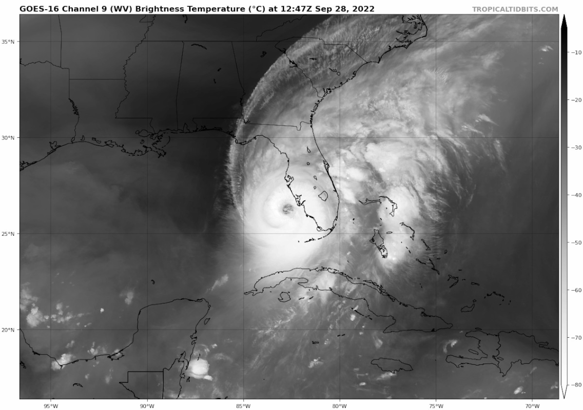
The NHC while awesome for hurricane track still has a lot to learn (like all of us) about intensity forecasting.
I’m calling Ian a Cat 5. Personal opinion based on experience.
Chuck
ATL: IAN - Post-Tropical - Discussion
Moderator: S2k Moderators
-
Rail Dawg
- S2K Supporter

- Posts: 326
- Joined: Mon Aug 27, 2012 5:02 pm
- Location: Where the eye makes landfall.
Re: ATL: IAN - Hurricane - Discussion
14 likes
Although I have been a hurricane forecaster since 1980 that only means I've been wrong lots of times.
Re: ATL: IAN - Hurricane - Discussion
sbcc wrote:Posting for caneman - this is a pic of the water, or rather the lack of it, in his canal near Indian Rocks...
FYI, the code instruction I posted is not working, need to copy the BBCode box there, then put it in the IMG tags. Sorry!
[url]https://i.ibb.co/Jjjx732/20220928-091135.jpg [/url]
Thank you.
5 likes
-
ThunderForce

- Tropical Storm

- Posts: 208
- Age: 26
- Joined: Tue Sep 27, 2022 6:20 pm
- Location: Calhoun County, Florida
Re: ATL: IAN - Hurricane - Discussion

According to the SPC, Ian and its bands will allow for slight and enhanced severe weather today which includes tornadoes. They're saying that the south-central peninsula and the Space Coast in particular have the highest chance of seeing tornadoes, and that there is the possibility for them to be strong EF2+ ones.
Even if you're outside of Ian's hurricane-force winds, please be very careful if you're in one of Ian's rain bands. The storm was spitting out tornadoes left and right last night and it is possible that it may resume doing so later today.
4 likes
Please refer to the NWS, NHC, SPC or a professional meteorologist for information and decision making during storms.
-
TheHurricaneGod
- Tropical Storm
- Posts: 165
- Age: 23
- Joined: Thu Apr 16, 2020 6:19 pm
- Location: Fort Lauderdale
Re: ATL: IAN - Hurricane - Discussion
Winds howling out there now. Just a few showers here on radar. Gusting to over 40 MPH at times
4 likes
-
Weatherboy1

- Category 5

- Posts: 1190
- Age: 50
- Joined: Mon Jul 05, 2004 1:50 pm
- Location: Jupiter/Sarasota, FL
Re: ATL: IAN - Hurricane - Discussion
Last few radar frames appear to show the eastern eyewall about to touch Sanibel Island.
5 likes
-
Iceresistance

- Category 5
- Posts: 9441
- Age: 22
- Joined: Sat Oct 10, 2020 9:45 am
- Location: Tecumseh, OK/Norman, OK
Re: ATL: IAN - Hurricane - Discussion
The last time that Southern Florida was hit by a CAT 5 was Andrew at Miami in 1992 from the east from The Bahamas.
Here coming from the west? I don't think that has ever happened before.
Here coming from the west? I don't think that has ever happened before.
Last edited by Iceresistance on Wed Sep 28, 2022 9:04 am, edited 1 time in total.
7 likes
Bill 2015 & Beta 2020
Winter 2020-2021
All observations are in Tecumseh, OK unless otherwise noted.
Winter posts are focused mainly for Oklahoma & Texas.
Take any of my forecasts with a grain of salt, refer to the NWS, SPC, and NHC for official information
Never say Never with weather! Because ANYTHING is possible!
Winter 2020-2021
All observations are in Tecumseh, OK unless otherwise noted.
Winter posts are focused mainly for Oklahoma & Texas.
Take any of my forecasts with a grain of salt, refer to the NWS, SPC, and NHC for official information
Never say Never with weather! Because ANYTHING is possible!
-
Kingarabian

- S2K Supporter
- Posts: 16293
- Joined: Sat Aug 08, 2009 3:06 am
- Location: Honolulu, Hawaii


-
ElectricStorm

- Category 5
- Posts: 5122
- Age: 24
- Joined: Tue Aug 13, 2019 11:23 pm
- Location: Skiatook, OK / Norman, OK
Re: ATL: IAN - Hurricane - Discussion
ThunderForce wrote:https://i.imgur.com/l3RdO3u.gif
According to the SPC, Ian and its bands will allow for slight and enhanced severe weather today which includes tornadoes. They're saying that the south-central peninsula and the Space Coast in particular have the highest chance of seeing tornadoes, and that there is the possibility for them to be strong EF2+ ones.
Even if you're outside of Ian's hurricane-force winds, please be very careful if you're in one of Ian's rain bands. The storm was spitting out tornadoes left and right last night and it is possible that it may resume doing so later today.
Was just about to post that. 10% tornado areas in a TC aren't too common, so this is likely going to be a pretty big deal unfortunately.
5 likes
B.S Meteorology, University of Oklahoma '25
Please refer to the NHC, NWS, or SPC for official information.
Please refer to the NHC, NWS, or SPC for official information.
-
ScottNAtlanta

- Category 5
- Posts: 2535
- Joined: Sat May 25, 2013 3:11 pm
- Location: Atlanta, GA
Re: ATL: IAN - Hurricane - Discussion
This is going to be Mexico Beach all over again except in a much higher populated area. This will devastate Florida's economy
10 likes
The posts in this forum are NOT official forecast and should not be used as such. They are just the opinion of the poster and may or may not be backed by sound meteorological data. They are NOT endorsed by any professional institution or storm2k.org. For official information, please refer to the NHC and NWS products.
-
Blown Away

- S2K Supporter
- Posts: 10253
- Joined: Wed May 26, 2004 6:17 am
Re: ATL: IAN - Hurricane - Discussion
Not moving to much
4 likes
Hurricane Eye Experience: David 79, Irene 99, Frances 04, Jeanne 04, Wilma 05… Hurricane Brush Experience: Andrew 92, Erin 95, Floyd 99, Matthew 16, Irma 17, Ian 22, Nicole 22…

Re: ATL: IAN - Hurricane - Discussion
caneman wrote:sbcc wrote:Posting for caneman - this is a pic of the water, or rather the lack of it, in his canal near Indian Rocks...
FYI, the code instruction I posted is not working, need to copy the BBCode box there, then put it in the IMG tags. Sorry!
https://i.ibb.co/Jjjx732/20220928-091135.jpg
Thank you.
Happy to help, when it settles down shoot me a PM and we can practice in the off topic section.
ETA - never mind, you got it figured out, you da man!
Last edited by sbcc on Wed Sep 28, 2022 10:07 am, edited 1 time in total.
2 likes


Re: ATL: IAN - Hurricane - Discussion
Rail Dawg wrote:The NHC while awesome for hurricane track still has a lot to learn (like all of us) about intensity forecasting.
I’m calling Ian a Cat 5. Personal opinion based on experience.
Chuck
I agree, the NHC will very unlikely upgrade it though. Wouldn’t make a difference anyways, still going to be a catastrophic event.
8 likes
-
ScottNAtlanta
- Category 5
- Posts: 2535
- Joined: Sat May 25, 2013 3:11 pm
- Location: Atlanta, GA
Re: ATL: IAN - Hurricane - Discussion
Iceresistance wrote:The last time that Southern Florida was hit by a CAT 5 was Andrew at Miami in 1992 from the east from The Bahamas.
Here coming from the west? I don't think that has ever happened before.
Andrew and Charley were relatively small compact storms. This is whole entirely different beast
13 likes
The posts in this forum are NOT official forecast and should not be used as such. They are just the opinion of the poster and may or may not be backed by sound meteorological data. They are NOT endorsed by any professional institution or storm2k.org. For official information, please refer to the NHC and NWS products.
-
Iceresistance
- Category 5
- Posts: 9441
- Age: 22
- Joined: Sat Oct 10, 2020 9:45 am
- Location: Tecumseh, OK/Norman, OK
Re: ATL: IAN - Hurricane - Discussion
After those 2 planes, when is the next recon if any?
3 likes
Bill 2015 & Beta 2020
Winter 2020-2021
All observations are in Tecumseh, OK unless otherwise noted.
Winter posts are focused mainly for Oklahoma & Texas.
Take any of my forecasts with a grain of salt, refer to the NWS, SPC, and NHC for official information
Never say Never with weather! Because ANYTHING is possible!
Winter 2020-2021
All observations are in Tecumseh, OK unless otherwise noted.
Winter posts are focused mainly for Oklahoma & Texas.
Take any of my forecasts with a grain of salt, refer to the NWS, SPC, and NHC for official information
Never say Never with weather! Because ANYTHING is possible!

Re: ATL: IAN - Hurricane - Discussion
Teban54 wrote:Food for thought:
In its last 6 hours before the Cuba landfall, Ian intensified from 90 kts to officially 110 kts (+20 kts). Many people here speculated it might have been a low-end Cat 4 (115 kts) at landfall.
Ian is now 105 kts and still has 15 hours before landfall.
Ian intensified by 30 kts (105 -> 135) in the 8 hours following this comment made at 11pm last night.
Last edited by Teban54 on Wed Sep 28, 2022 9:12 am, edited 1 time in total.
7 likes
TC naming lists: retirements and intensity
Most aggressive Advisory #1's in North Atlantic (cr. kevin for starting the list)
Most aggressive Advisory #1's in North Atlantic (cr. kevin for starting the list)
-
Hurricane2022

- Category 5
- Posts: 1974
- Joined: Tue Aug 23, 2022 11:38 pm
- Location: Araçatuba, Brazil
Re: ATL: IAN - Hurricane - Discussion
This actual recon mission ended?
1 likes
Sorry for the bad English sometimes...!
For reliable and detailed information for any meteorological phenomenon, please consult the National Hurricane Center, Joint Typhoon Warning Center , or your local Meteo Center.
--------
ECCE OMNIA NOVA FACIAM (Ap 21,5).
For reliable and detailed information for any meteorological phenomenon, please consult the National Hurricane Center, Joint Typhoon Warning Center , or your local Meteo Center.
--------
ECCE OMNIA NOVA FACIAM (Ap 21,5).
Re: ATL: IAN - Hurricane - Discussion
Sanibel wrote:Gulf stream juice creates fully presented category 5 appearance...Slow grinding turn looks like it might be happening...National Hurricane Center says 18 foot surge possible...House is toast...
Sanibel (the user), I vividly remember when you said this might be the storm for Sanibel (the island), back when model runs and the NHC forecast were just shifting south and not even at the island yet. Unfortunately, that fear came true in the worst way possible.
Many prayers.
5 likes
TC naming lists: retirements and intensity
Most aggressive Advisory #1's in North Atlantic (cr. kevin for starting the list)
Most aggressive Advisory #1's in North Atlantic (cr. kevin for starting the list)
-
ElectricStorm
- Category 5
- Posts: 5122
- Age: 24
- Joined: Tue Aug 13, 2019 11:23 pm
- Location: Skiatook, OK / Norman, OK
Re: ATL: IAN - Hurricane - Discussion
Hurricane2022 wrote:This actual recon mission ended?
On TT is says it's finished but it looks like they turned around and started descending again, so maybe they decided to get one more pass. If so that's a massive W for them
2 likes
B.S Meteorology, University of Oklahoma '25
Please refer to the NHC, NWS, or SPC for official information.
Please refer to the NHC, NWS, or SPC for official information.
-
typhoonty
- Tropical Storm
- Posts: 121
- Age: 31
- Joined: Wed May 31, 2017 10:37 pm
- Location: Fort Myers / Tallahassee, FL
- Contact:
Re: ATL: IAN - Hurricane - Discussion
It was relayed to me that they are hesitant to upgrade to a 5 because the pressure is too high and they would rather use a blend the FL winds of the AF and NOAA. Eric Blake said they could go 135 or 140 kt
Ian is still intensifying but even if they don’t go cat 5 today it has far more evidence than Michael to support an upgrade to 5.
I live in Iona right on the Caloosahatchee and have accepted that I will probably lose everything except my life because I evacuated to Fort Lauderdale last night. My godmother though stayed in zone A and is in grave danger
10 likes
FSU Meteorology student, opinions are mine, 20 years experience covering TC's, consult NHC/Local officials when making decisions.
Gabrielle '01, Michelle '01, Charley '04, Frances '04, Dennis '05, Katrina '05, Rita '05, Wilma '05, Fay '08, Isaac '12 Hermine '16, Irma '17, Michael '18, Eta '20, Elsa '21, IAN '22, Idalia '23, Debby '24, Helene '24
Gabrielle '01, Michelle '01, Charley '04, Frances '04, Dennis '05, Katrina '05, Rita '05, Wilma '05, Fay '08, Isaac '12 Hermine '16, Irma '17, Michael '18, Eta '20, Elsa '21, IAN '22, Idalia '23, Debby '24, Helene '24
Who is online
Users browsing this forum: No registered users and 11 guests