ATL: IAN - Post-Tropical - Discussion

Moderator: S2k Moderators

Message
Author
FLLurker32
Tropical Storm
Tropical Storm
Posts: 245
Joined: Mon Aug 29, 2016 10:31 am

Re: ATL: IAN - Hurricane - Discussion

#5781 Postby FLLurker32 » Thu Sep 29, 2022 5:09 pm

typhoonty wrote:
FLLurker32 wrote:Getting some pretty decent gusts on the very southern end of Marion county. I’m only a mile north of Lake and Sumter counties. It’s been raining all day, sometimes a drizzle sometimes heavy. More interestingly, there’s been a lot of lightening and it’s very cool here. Around 70 degrees. After such a hot summer I need a jacket just to tolerate the cold wind. I said it earlier but it’s worth repeating - what an odd mix of a tropical storm winds with fall weather. Can’t remember one quite like this in nearly 40 yrs.


Irma was like this in Tallahassee, there was dry air on the back side as there was definitely some baroclinic processes at play. The high in Tallahassee on 9/11/17 was 66, which is a monthly record. Strong NW winds act the same way as cold front and efficiently bring in record cold temperatures on the back side of the hurricane. Unfortunately, a tremendous price to pay for incredible weather in Florida for September standards.

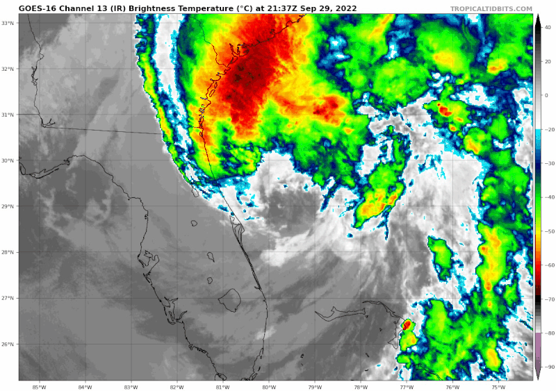
You could also see the baroclinic forcing start when it was ramping up to it's peak overnight and early morning Wednesday. Exceptionally tremendous lightning in the NW eyewall closest to the trough and hail during that mission which you would literally never see without it being an (exceptionally strong) hybrid.


I was thinking about this last night. With Irma we had a week of cooler temps then a warm up just before we were hit. I don’t remember lightening, though. I do, however remember the winds picking up just as the cold air was moving in. That clash definitely causes some interesting things to happen. Unfortunately, it was short lived and we had nearly 2 weeks of no power in sweltering heat after.
0 likes   
Heather

User avatar
HouTXmetro
Category 5
Category 5
Posts: 3949
Joined: Sun Jun 13, 2004 6:00 pm
Location: District of Columbia, USA

Re: ATL: IAN - Tropical Storm - Discussion

#5782 Postby HouTXmetro » Thu Sep 29, 2022 5:16 pm

FLLurker32 wrote:
Sanibel wrote:Sanibel Causeway had section washed-out...Zero word from island...Chinooks landing at RSW...

My mother died during Ian in the storm...


I am so incredibly sorry to hear of your loss. There really aren’t words. Just thinking of you and your family.


My sincere condolences Sanibel. God Bless you and her loved ones.
1 likes   
[Disclaimer: My Amateur Opinion, please defer to your local authorities or the NHC for Guidance.]

User avatar
GCANE
S2K Supporter
S2K Supporter
Posts: 11496
Joined: Mon Oct 22, 2007 8:03 am

Re: ATL: IAN - Tropical Storm - Discussion

#5783 Postby GCANE » Thu Sep 29, 2022 5:23 pm

HouTXmetro wrote:
FLLurker32 wrote:
Sanibel wrote:Sanibel Causeway had section washed-out...Zero word from island...Chinooks landing at RSW...

My mother died during Ian in the storm...


I am so incredibly sorry to hear of your loss. There really aren’t words. Just thinking of you and your family.


My sincere condolences Sanibel. God Bless you and her loved ones.


My heart-felt condolences as well Sanibel. I know, its a terrible sting when a loved one dies. God Bless.
0 likes   

User avatar
Steve
S2K Supporter
S2K Supporter
Posts: 9621
Joined: Sat Apr 05, 2003 11:41 pm
Location: Not a state-caster

Re: ATL: IAN - Tropical Storm - Discussion

#5784 Postby Steve » Thu Sep 29, 2022 5:31 pm

St. Augustine got a bunch of inundation yesterday and today as well. I disagreed a little the other day downplaying the EC of Florida because we saw what happened with Irma. It affected coastal areas a little farther south, but I remember reading a lot of people saying it was more than they bargained for on the Atlantic side. Surge will come in wherever it is directed and will take paths of least resistance which are often inlets, bays, rivers, etc. i love that city and St. Augustine Beach.

Hopefully most people get it now that a hurricane coming into SWFL can still have strong effects on the east coast. Florida is only 150-160 miles wide, and feeder bands setting up or rotating through while often tapping into the Atlantic can bring trouble.
5 likes   

curtadams
S2K Supporter
S2K Supporter
Posts: 1122
Joined: Sun Aug 28, 2005 7:57 pm
Location: Orange, California
Contact:

Re: ATL: IAN - Hurricane - Discussion

#5785 Postby curtadams » Thu Sep 29, 2022 5:31 pm

FLLurker32 wrote:My comment said that the models were not broadly shared, and they weren’t. You had to seek them out and if you did so it was typically because you knew something about them. Today, they’re too broadly shared and available to the masses that do not know and do not care to know what they mean and are intended for. This is just one of the many areas of science currently impacted by the rise of social media. I think many Mets have taken the approach of trying to teach the masses to offset the effects of it, but it doesn’t seem to be working.

The problem with sharing the models more widely is that most people can't deal with uncertainty. Show a typical person a spaghetti plot and they'll just throw up their hands. A lot of people can't do risk assessment either. They look at a $1000 cost for an evac, maybe even do it a few times, and think it's too much, although if it prevents even a 1 in a 1000 chance of dying it's a big win.

The current NHC strategy of downplaying the uncertainty but pushing hard for evac and preparation in targeted areas is based on what they've found actually minimizes lives lost. They give the (exaggerated) certainty most people require before they'll actually take action. In this case there was also a fairly unusual combination of circumstances which meant if the hurricane veered moderately right of expectations it came in earlier AND harder, so perhaps the NHC in the future should tweak their cone a bit to cover places where hits will be especially hard.

Also, don't forget the severity was a surprise to almost everybody. There has NEVER been a storm that increased in strength in that location. https://twitter.com/splillo/status/1575117958111588356 I was quite shocked to wake up Wed morning (west coast time) to see an almost-5-and-maybe-actually-5 bearing down on FL. To some extent we are dealing with the "new normal" of climate change and it's just a bitter truth we're going to get horrible surprises like this.
3 likes   

dukeblue219
S2K Supporter
S2K Supporter
Posts: 535
Joined: Fri Sep 30, 2016 3:52 pm

Re: ATL: IAN - Tropical Storm - Discussion

#5786 Postby dukeblue219 » Thu Sep 29, 2022 5:33 pm

It certainly doesn't look very tropical on satellite for a hurricane. Curious to see if any convection can wrap overnight.

Image
2 likes   

User avatar
ScottNAtlanta
Category 5
Category 5
Posts: 2367
Joined: Sat May 25, 2013 3:11 pm
Location: Atlanta, GA

Re: ATL: IAN - Tropical Storm - Discussion

#5787 Postby ScottNAtlanta » Thu Sep 29, 2022 5:35 pm

I have been combing through the news coverage today trying to find out about damage in the area where my parents are supposed to be going in 2 weeks, and I ran across a story that seems relevant to a conversation thread here. A woman and her husband with a 21 month old baby left Tampa to go to her in-laws house to the south in Punta Gorda to avoid the storm. They got there, realized the track had changed,and there was no where they could get gas to go back, and there was a lot of misinformation flying around about shelters being full that was not true, and they ended up having to ride it out in their house. They watched both neighbors roofs fly off, but they were all ok. When it comes to information like this in an emergency, GOVERNMENT sources are the ONLY sources you should trust. People can say what they want about it, but these people's only job is service to their community and keeping people safe. Facebook doesn't care, Twitter doesn't care, and Reddit doesn't care. Only government (local or otherwise) sources should be used to make those decisions.
11 likes   
The posts in this forum are NOT official forecast and should not be used as such. They are just the opinion of the poster and may or may not be backed by sound meteorological data. They are NOT endorsed by any professional institution or storm2k.org. For official information, please refer to the NHC and NWS products.

User avatar
Iceresistance
Category 5
Category 5
Posts: 9288
Age: 21
Joined: Sat Oct 10, 2020 9:45 am
Location: Tecumseh, OK/Norman, OK

Re: ATL: IAN - Tropical Storm - Discussion

#5788 Postby Iceresistance » Thu Sep 29, 2022 5:40 pm

This was from yesterday, but it's not just sharks that you need to watch for. Florida is notorious for Gators.

 https://twitter.com/WESH/status/1575256609361743872


1 likes   
Bill 2015 & Beta 2020

Winter 2020-2021 :cold:

All observations are in Tecumseh, OK unless otherwise noted.

Winter posts are focused mainly for Oklahoma & Texas.

Take any of my forecasts with a grain of salt, refer to the NWS, SPC, and NHC for official information

Never say Never with weather! Because ANYTHING is possible!

User avatar
ScottNAtlanta
Category 5
Category 5
Posts: 2367
Joined: Sat May 25, 2013 3:11 pm
Location: Atlanta, GA

Re: ATL: IAN - Hurricane - Discussion

#5789 Postby ScottNAtlanta » Thu Sep 29, 2022 5:43 pm

curtadams wrote:There has NEVER been a storm that increased in strength in that location. https://twitter.com/splillo/status/1575117958111588356 I was quite shocked to wake up Wed morning (west coast time) to see an almost-5-and-maybe-actually-5 bearing down on FL. To some extent we are dealing with the "new normal" of climate change and it's just a bitter truth we're going to get horrible surprises like this.


The ships RI index was running 90% pretty much consistently from before it even hit Cuba. While shocking, it should not have been that big of a surprise to anyone who follows this stuff more than casually. I saw plenty of reporting from experts that said this was possible. The NHC was forecasting a cat 4, they just thought it would weaken, but the southern track took that off the table. The last several strong hurricane hits have been intensifying up until landfall. In fact, I can't think of one that wasn't since Michael.
6 likes   
The posts in this forum are NOT official forecast and should not be used as such. They are just the opinion of the poster and may or may not be backed by sound meteorological data. They are NOT endorsed by any professional institution or storm2k.org. For official information, please refer to the NHC and NWS products.

Vdogg
Category 2
Category 2
Posts: 621
Joined: Wed Aug 31, 2016 9:56 am

Re: ATL: IAN - Tropical Storm - Discussion

#5790 Postby Vdogg » Thu Sep 29, 2022 5:45 pm

dukeblue219 wrote:It certainly doesn't look very tropical on satellite for a hurricane. Curious to see if any convection can wrap overnight.

[url]https://i.postimg.cc/3RFy6GFs/44f3aa4d-3b40-4e8d-8c17-14620a5bfaac.gif [/url]

NHC said it's a hybrid cyclone but they expect it to wrap and strengthen overnight.
1 likes   

User avatar
ScottNAtlanta
Category 5
Category 5
Posts: 2367
Joined: Sat May 25, 2013 3:11 pm
Location: Atlanta, GA

Re: ATL: IAN - Tropical Storm - Discussion

#5791 Postby ScottNAtlanta » Thu Sep 29, 2022 5:46 pm

Vdogg wrote:
dukeblue219 wrote:It certainly doesn't look very tropical on satellite for a hurricane. Curious to see if any convection can wrap overnight.

[url]https://i.postimg.cc/3RFy6GFs/44f3aa4d-3b40-4e8d-8c17-14620a5bfaac.gif [/url]

NHC said it's a hybrid cyclone but they expect it to wrap and strengthen overnight.

It doesn't look very tropical right now.

We have had some really strong wind gusts here in Atlanta of all places. It blew 2 ficus trees (about 7 ft tall) in some pretty heavy pots over. Twice already
0 likes   
The posts in this forum are NOT official forecast and should not be used as such. They are just the opinion of the poster and may or may not be backed by sound meteorological data. They are NOT endorsed by any professional institution or storm2k.org. For official information, please refer to the NHC and NWS products.

rhwxgeek
Tropical Low
Tropical Low
Posts: 39
Joined: Wed Oct 10, 2018 10:18 am

Re: ATL: IAN - Tropical Storm - Discussion

#5792 Postby rhwxgeek » Thu Sep 29, 2022 5:52 pm

Sanibel wrote:Sanibel Causeway had section washed-out...Zero word from island...Chinooks landing at RSW...

My mother died during Ian in the storm...


My thoughts and condolences are with you and your family. I am so sorry to hear about your loss.
1 likes   

User avatar
Teban54
Category 5
Category 5
Posts: 3204
Joined: Sat May 19, 2018 1:19 pm

Re: ATL: IAN - Hurricane - Discussion

#5793 Postby Teban54 » Thu Sep 29, 2022 5:53 pm

ScottNAtlanta wrote:In fact, I can't think of one that wasn't since Michael.

Not to be that guy, but Delta weakened before both its landfalls.
3 likes   

User avatar
ScottNAtlanta
Category 5
Category 5
Posts: 2367
Joined: Sat May 25, 2013 3:11 pm
Location: Atlanta, GA

Re: ATL: IAN - Tropical Storm - Discussion

#5794 Postby ScottNAtlanta » Thu Sep 29, 2022 5:54 pm

I meant to post this yesterday, but if you ever want to see a textbook example of an EWRC this would be it

[youtube]https://youtu.be/nCs23HubFfI[/youtube]

As an extra bonus...there is a real pinhole eye thrown in no extra charge
3 likes   
The posts in this forum are NOT official forecast and should not be used as such. They are just the opinion of the poster and may or may not be backed by sound meteorological data. They are NOT endorsed by any professional institution or storm2k.org. For official information, please refer to the NHC and NWS products.

User avatar
birdwomn
Category 1
Category 1
Posts: 419
Joined: Wed Aug 11, 2004 8:04 pm
Location: Pinellas County FL

Re: ATL: IAN - Hurricane - Discussion

#5795 Postby birdwomn » Thu Sep 29, 2022 5:56 pm

curtadams wrote:
FLLurker32 wrote:My comment said that the models were not broadly shared, and they weren’t. You had to seek them out and if you did so it was typically because you knew something about them. Today, they’re too broadly shared and available to the masses that do not know and do not care to know what they mean and are intended for. This is just one of the many areas of science currently impacted by the rise of social media. I think many Mets have taken the approach of trying to teach the masses to offset the effects of it, but it doesn’t seem to be working.

The problem with sharing the models more widely is that most people can't deal with uncertainty. Show a typical person a spaghetti plot and they'll just throw up their hands. A lot of people can't do risk assessment either. They look at a $1000 cost for an evac, maybe even do it a few times, and think it's too much, although if it prevents even a 1 in a 1000 chance of dying it's a big win.

The current NHC strategy of downplaying the uncertainty but pushing hard for evac and preparation in targeted areas is based on what they've found actually minimizes lives lost. They give the (exaggerated) certainty most people require before they'll actually take action. In this case there was also a fairly unusual combination of circumstances which meant if the hurricane veered moderately right of expectations it came in earlier AND harder, so perhaps the NHC in the future should tweak their cone a bit to cover places where hits will be especially hard.

Also, don't forget the severity was a surprise to almost everybody. There has NEVER been a storm that increased in strength in that location. https://twitter.com/splillo/status/1575117958111588356 I was quite shocked to wake up Wed morning (west coast time) to see an almost-5-and-maybe-actually-5 bearing down on FL. To some extent we are dealing with the "new normal" of climate change and it's just a bitter truth we're going to get horrible surprises like this.


Speaking of spaghetti models: I will say it drives me a bit crazy that they show the spaghetti models on TV because they virtually never explain what they are showing and very few members of the general public understand what they are seeing and which models are reliable and which and not so reliable. Just my two fifths of a a dime on the topic.
4 likes   

tolakram
Admin
Admin
Posts: 20009
Age: 62
Joined: Sun Aug 27, 2006 8:23 pm
Location: Florence, KY (name is Mark)

Re: ATL: IAN - Hurricane - Discussion

#5796 Postby tolakram » Thu Sep 29, 2022 5:56 pm

curtadams wrote:
FLLurker32 wrote:My comment said that the models were not broadly shared, and they weren’t. You had to seek them out and if you did so it was typically because you knew something about them. Today, they’re too broadly shared and available to the masses that do not know and do not care to know what they mean and are intended for. This is just one of the many areas of science currently impacted by the rise of social media. I think many Mets have taken the approach of trying to teach the masses to offset the effects of it, but it doesn’t seem to be working.

The problem with sharing the models more widely is that most people can't deal with uncertainty. Show a typical person a spaghetti plot and they'll just throw up their hands. A lot of people can't do risk assessment either. They look at a $1000 cost for an evac, maybe even do it a few times, and think it's too much, although if it prevents even a 1 in a 1000 chance of dying it's a big win.

The current NHC strategy of downplaying the uncertainty but pushing hard for evac and preparation in targeted areas is based on what they've found actually minimizes lives lost. They give the (exaggerated) certainty most people require before they'll actually take action. In this case there was also a fairly unusual combination of circumstances which meant if the hurricane veered moderately right of expectations it came in earlier AND harder, so perhaps the NHC in the future should tweak their cone a bit to cover places where hits will be especially hard.

Also, don't forget the severity was a surprise to almost everybody. There has NEVER been a storm that increased in strength in that location. https://twitter.com/splillo/status/1575117958111588356 I was quite shocked to wake up Wed morning (west coast time) to see an almost-5-and-maybe-actually-5 bearing down on FL. To some extent we are dealing with the "new normal" of climate change and it's just a bitter truth we're going to get horrible surprises like this.


If people are looking for a reason not to evacuate they will find one. Not sure we can fix that problem, but I do think the presentation of the forecast can be improved. Any element, like the cone, that needs to be explained even to enthusiasts is failing. It would be nice to believe that people living on the coast would go the extra step of knowing how to interpret a forecast, but there's a number that just won't. Can we communicate better with those people?

Severity should not have been a surprise, it was well forecast, yet people were still surprised. It's still a human factors problem. Just look at pre and post Ian. Hype, hype, not enough warning. That's a tough problem to solve. The largest population center was hyped the most due to the potential impact. The storm ended up moving further south, within the expected margin of error, and are we saying it wasn't hyped enough down near where it hit?

I don't think Florida peninsula will get a more accurate hurricane forecast in most of our lifetimes. The angle of approach is usually one of the worst for predicting landfalls, even a wobble can end up changing landfall by a hundred miles.
8 likes   
M a r k
- - - - -
Join us in chat: Storm2K Chatroom Invite. Android and IOS apps also available.

The posts in this forum are NOT official forecasts and should not be used as such. Posts are NOT endorsed by any professional institution or STORM2K.org. For official information and forecasts, please refer to NHC and NWS products.

User avatar
Teban54
Category 5
Category 5
Posts: 3204
Joined: Sat May 19, 2018 1:19 pm

Re: ATL: IAN - Tropical Storm - Discussion

#5797 Postby Teban54 » Thu Sep 29, 2022 5:58 pm

ScottNAtlanta wrote:I meant to post this yesterday, but if you ever want to see a textbook example of an EWRC this would be it

https://youtu.be/nCs23HubFfI

As an extra bonus...there is a real pinhole eye thrown in no extra charge

This really puts into perspective how quick Ian's EWRC was compared to most cases.
0 likes   

User avatar
ScottNAtlanta
Category 5
Category 5
Posts: 2367
Joined: Sat May 25, 2013 3:11 pm
Location: Atlanta, GA

Re: ATL: IAN - Hurricane - Discussion

#5798 Postby ScottNAtlanta » Thu Sep 29, 2022 6:00 pm

birdwomn wrote:Speaking of spaghetti models: I will say it drives me a bit crazy that they show the spaghetti models on TV because they virtually never explain what they are showing and very few members of the general public understand what they are seeing and which models are reliable and which and not so reliable. Just my two fifths of a a dime on the topic.


I agree 100% with this. I am always glad in Levi's videos and on his website he goes out of his way to say that you should not use those as a forecast unless you know how to read them.
1 likes   
The posts in this forum are NOT official forecast and should not be used as such. They are just the opinion of the poster and may or may not be backed by sound meteorological data. They are NOT endorsed by any professional institution or storm2k.org. For official information, please refer to the NHC and NWS products.

User avatar
ScottNAtlanta
Category 5
Category 5
Posts: 2367
Joined: Sat May 25, 2013 3:11 pm
Location: Atlanta, GA

Re: ATL: IAN - Tropical Storm - Discussion

#5799 Postby ScottNAtlanta » Thu Sep 29, 2022 6:02 pm

Teban54 wrote:
ScottNAtlanta wrote:I meant to post this yesterday, but if you ever want to see a textbook example of an EWRC this would be it

https://youtu.be/nCs23HubFfI

As an extra bonus...there is a real pinhole eye thrown in no extra charge

This really puts into perspective how quick Ian's EWRC was compared to most cases.


It wasn't nearly as extreme. Every storm is different in that respect. Like a finger print. Laura never had one, and some others have one every six hours it seems. I dont think we are at a point where we totally know what causes them to happen either.
3 likes   
The posts in this forum are NOT official forecast and should not be used as such. They are just the opinion of the poster and may or may not be backed by sound meteorological data. They are NOT endorsed by any professional institution or storm2k.org. For official information, please refer to the NHC and NWS products.

User avatar
Steve
S2K Supporter
S2K Supporter
Posts: 9621
Joined: Sat Apr 05, 2003 11:41 pm
Location: Not a state-caster

Re: ATL: IAN - Tropical Storm - Discussion

#5800 Postby Steve » Thu Sep 29, 2022 6:03 pm

ScottNAtlanta wrote:
Vdogg wrote:
dukeblue219 wrote:It certainly doesn't look very tropical on satellite for a hurricane. Curious to see if any convection can wrap overnight.

[url]https://i.postimg.cc/3RFy6GFs/44f3aa4d-3b40-4e8d-8c17-14620a5bfaac.gif [/url]

NHC said it's a hybrid cyclone but they expect it to wrap and strengthen overnight.

It doesn't look very tropical right now.

We have had some really strong wind gusts here in Atlanta of all places. It blew 2 ficus trees (about 7 ft tall) in some pretty heavy pots over. Twice already


It’s north weighted and likely to be NW weighted as it goes inland because it’s butt-up to the trough to the west. KJAX radar

https://www.weather.gov/jax/

Water Vapor showing it up against the extremely dry, Fall air.

https://www.tropicaltidbits.com/sat/sat ... uct=wv_mid

—————
I don’t really know what to say about information. People even seek out misinformation these days, and there are plenty of trolls willing to provide it. Rumors (and b.s.) have always been part of the hurricane story on the ground. That isn’t going to change. Remember back to first grade when they taught you how gossip works by someone telling you something and as it gets passed along morphs into something completely different and often exaggerated. I’ve been hearing from official sources to “ignore rumors” since I was a little kid. It’s easy to get caught up in the moment, but a good rule is if it’s more than second hand, disregard it.
3 likes   


Return to “2022”

Who is online

Users browsing this forum: No registered users and 12 guests