
This should work, don't know how accurate it is of course but it updates regularly and has pressure, winds, direction and gusts.[/quote]
Many thanks!
EPAC: ORLENE - Remnants
Moderator: S2k Moderators
Re: EPAC: ORLENE - Hurricane
0 likes
Personal Forecast Disclaimer:
The posts in this forum are NOT official forecast and should not be used as such. They are just the opinion of the poster and may or may not be backed by sound meteorological data. For official information, please refer to the NHC and NWS products.
The posts in this forum are NOT official forecast and should not be used as such. They are just the opinion of the poster and may or may not be backed by sound meteorological data. For official information, please refer to the NHC and NWS products.
Re: EPAC: ORLENE - Hurricane
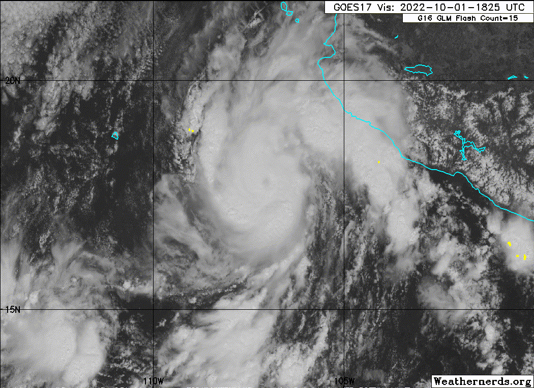
Appears to be a lot stronger than the estimates. Bombing right now on IR.
0 likes
Personal Forecast Disclaimer:
The posts in this forum are NOT official forecast and should not be used as such. They are just the opinion of the poster and may or may not be backed by sound meteorological data. For official information, please refer to the NHC and NWS products.
The posts in this forum are NOT official forecast and should not be used as such. They are just the opinion of the poster and may or may not be backed by sound meteorological data. For official information, please refer to the NHC and NWS products.
Re: EPAC: ORLENE - Hurricane
21.651127849807676, -106.53829069248302
Location of that weather station.
Location of that weather station.
0 likes
Personal Forecast Disclaimer:
The posts in this forum are NOT official forecast and should not be used as such. They are just the opinion of the poster and may or may not be backed by sound meteorological data. For official information, please refer to the NHC and NWS products.
The posts in this forum are NOT official forecast and should not be used as such. They are just the opinion of the poster and may or may not be backed by sound meteorological data. For official information, please refer to the NHC and NWS products.
-
Netzero9455
- Tropical Low

- Posts: 19
- Joined: Sun Oct 23, 2016 6:23 pm
Re: EPAC: ORLENE - Hurricane
Is that an eye already popping out on IR? Hoping it doesn't go right of track like Ian consistently did, would really increase probability of significant damage in the Banderas Bay area, especially the Punta Mita region sitting out on a cape.
0 likes

Re: EPAC: ORLENE - Hurricane
The best looking EPac storm in weeks.

2 likes
Irene '11 Sandy '12 Hermine '16 5/15/2018 Derecho Fay '20 Isaias '20 Elsa '21 Henri '21 Ida '21
I am only a meteorology enthusiast who knows a decent amount about tropical cyclones. Look to the professional mets, the NHC, or your local weather office for the best information.
I am only a meteorology enthusiast who knows a decent amount about tropical cyclones. Look to the professional mets, the NHC, or your local weather office for the best information.
-
Hurricane2022

- Category 5

- Posts: 2093
- Joined: Tue Aug 23, 2022 11:38 pm
- Location: Araçatuba, Brazil
Re: EPAC: ORLENE - Hurricane
I'm wondering if tomorrow's next recon can find Orlene at her peak intensity, since an increase in Wind Shear is predicted for the next 18 - 24 hours
2 likes
Sorry for the bad English sometimes...!
For reliable and detailed information for any meteorological phenomenon, please consult the National Hurricane Center, Joint Typhoon Warning Center , or your local Meteo Center.
--------
ECCE OMNIA NOVA FACIAM (Ap 21,5).
For reliable and detailed information for any meteorological phenomenon, please consult the National Hurricane Center, Joint Typhoon Warning Center , or your local Meteo Center.
--------
ECCE OMNIA NOVA FACIAM (Ap 21,5).
-
Sciencerocks
- Category 5
- Posts: 10193
- Age: 40
- Joined: Thu Jul 06, 2017 1:51 am
Re: EPAC: ORLENE - Hurricane
I think has a good chance at getting to 90 knots or more in the next 12-24 hours before the shear.
2 likes

Re: EPAC: ORLENE - Hurricane
Definitely looks like an RI'ing storm. It's been a while since this happened in the EPac...
0 likes
TC naming lists: retirements and intensity
Most aggressive Advisory #1's in North Atlantic (cr. kevin for starting the list)
Most aggressive Advisory #1's in North Atlantic (cr. kevin for starting the list)
-
Kingarabian

- S2K Supporter

- Posts: 16379
- Joined: Sat Aug 08, 2009 3:06 am
- Location: Honolulu, Hawaii
Re: EPAC: ORLENE - Hurricane
If the shear doesn't kick in sooner than forecast, it's well on jts way to MH status. Might be the strongest system of the EPAC season when it's done.
0 likes
RIP Kobe Bryant
-
Yellow Evan

- Professional-Met

- Posts: 16257
- Age: 27
- Joined: Fri Jul 15, 2011 12:48 pm
- Location: Henderson, Nevada/Honolulu, HI
- Contact:
Re: EPAC: ORLENE - Hurricane
Kingarabian wrote:If the shear doesn't kick in sooner than forecast, it's well on jts way to MH status. Might be the strongest system of the EPAC season when it's done.
Did you forget about Darby?
3 likes
-
Yellow Evan
- Professional-Met
- Posts: 16257
- Age: 27
- Joined: Fri Jul 15, 2011 12:48 pm
- Location: Henderson, Nevada/Honolulu, HI
- Contact:

-
zeehag
- Tropical Storm

- Posts: 181
- Age: 77
- Joined: Sun Jul 17, 2011 9:49 pm
- Location: mazatlan,sinaloa, mexico, fixing patricia's mess.
- Contact:
Re: EPAC: ORLENE - Hurricane
watching this one closely as my boats life depends on its passing faraway and smoothly.,.... escuinapa will do nicely.
0 likes
-
cycloneye

- Admin

- Posts: 149730
- Age: 69
- Joined: Thu Oct 10, 2002 10:54 am
- Location: San Juan, Puerto Rico
Re: EPAC: ORLENE - Hurricane
Hurricane Orlene Tropical Cyclone Update
NWS National Hurricane Center Miami FL EP162022
515 PM MDT Sat Oct 01 2022
...SATELLITE DATA INDICATE ORLENE IS RAPIDLY STRENGTHENING...
Satellite data indicate that Orlene is rapidly strengthening, with
maximum sustained winds estimated to be 105 mph (170 km/h). A
special advisory will be issued by 6 PM MDT (0000 UTC) and will
replace the intermediate advisory.
SUMMARY OF 515 PM MDT...2315 UTC...INFORMATION
----------------------------------------------
LOCATION...18.0N 107.0W
ABOUT 185 MI...300 KM SSW OF CABO CORRIENTES MEXICO
ABOUT 245 MI...395 KM S OF LAS ISLAS MARIAS MEXICO
MAXIMUM SUSTAINED WINDS...105 MPH...165 KM/H
PRESENT MOVEMENT...N OR 360 DEGREES AT 5 MPH...7 KM/H
MINIMUM CENTRAL PRESSURE...970 MB...28.64 INCHES
$$
Forecaster Reinhart
0 likes
Visit the Caribbean-Central America Weather Thread where you can find at first post web cams,radars
and observations from Caribbean basin members Click Here
and observations from Caribbean basin members Click Here
-
Yellow Evan
- Professional-Met
- Posts: 16257
- Age: 27
- Joined: Fri Jul 15, 2011 12:48 pm
- Location: Henderson, Nevada/Honolulu, HI
- Contact:

-
Netzero9455
- Tropical Low
- Posts: 19
- Joined: Sun Oct 23, 2016 6:23 pm
Re: EPAC: ORLENE - Hurricane
zeehag wrote:watching this one closely as my boats life depends on its passing faraway and smoothly.,.... escuinapa will do nicely.
Would it not be possible to move the boat 100 miles north with 2 days advance? I say this because as I understand it you live on your boat full-time, and would be quite worried if I were in that situation. I remember you being very close to Patricia's eyewall at the time of landfall as well 7 years ago, I've been a permanent resident of Puerto Vallarta for the last 20 years almost, so I was very worried at the time because originally the landfall point forecast was much further to the north, and could have represented an enormous disaster, vs. what we actually got which was a constant drizzle for about 2 days and maybe 10mph of wind due to the Sierra Madre mountains to the south basically acting as a wall against the wind, so the only way we get significantly impacted basically is if a hurricane approaches from the southwest with a landfall point of San Blas to Punta Mita, even if it comes in 50 miles to the south we get mostly nothing except for more intense rain because of the aforementioned mountains. Unfortunately all the communites on the Costalegre coast on the other side of the mountains get pounded by at least 1 storm a year passing to the west on the northwestward heading out to sea that many early to mid-season hurricanes take before cold fronts begin to start dropping down to this latitude in October eroding the ridge.
1 likes
-
cycloneye
- Admin
- Posts: 149730
- Age: 69
- Joined: Thu Oct 10, 2002 10:54 am
- Location: San Juan, Puerto Rico
Re: EPAC: ORLENE - Hurricane
BULLETIN
Hurricane Orlene Special Advisory Number 13
NWS National Hurricane Center Miami FL EP162022
600 PM MDT Sat Oct 01 2022
...ORLENE IS RAPIDLY STRENGTHENING...
SUMMARY OF 600 PM MDT...0000 UTC...INFORMATION
----------------------------------------------
LOCATION...18.2N 107.1W
ABOUT 175 MI...285 KM SSW OF CABO CORRIENTES MEXICO
ABOUT 230 MI...375 KM S OF LAS ISLAS MARIAS MEXICO
MAXIMUM SUSTAINED WINDS...105 MPH...165 KM/H
PRESENT MOVEMENT...N OR 360 DEGREES AT 6 MPH...9 KM/H
MINIMUM CENTRAL PRESSURE...970 MB...28.65 INCHES
Hurricane Orlene Special Discussion Number 13
NWS National Hurricane Center Miami FL EP162022
600 PM MDT Sat Oct 01 2022
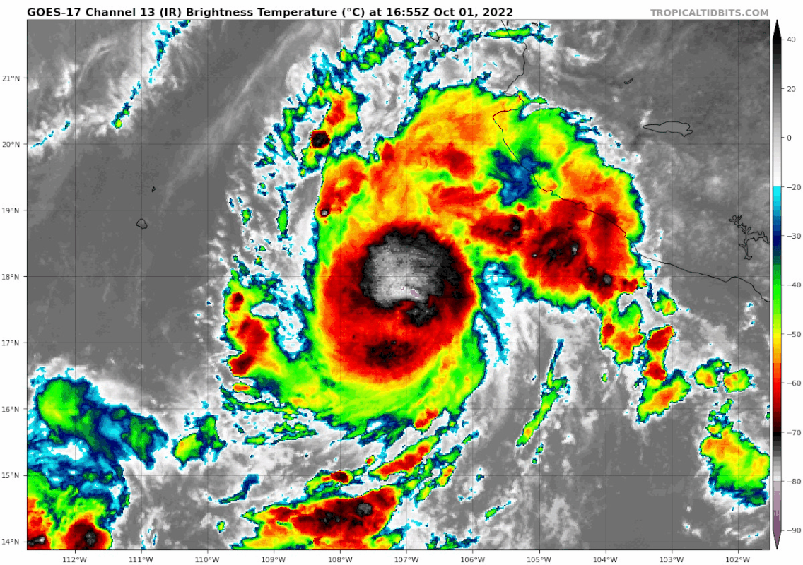
The satellite presentation of Orlene has quickly improved during the
past several hours. A warm and well-defined eye has emerged in
GOES-17 satellite imagery, surrounded by a solid ring of deep
convection with infrared cloud tops colder than -70 degrees Celsius.
The initial intensity is set at 90 kt for this advisory based on
recent satellite intensity estimates.
Based on the higher initial intensity, the near-term intensity
forecast has been raised to show additional strengthening in the
next 12-24 h while environmental conditions remain conducive for
intensification. No changes were made to the track forecast with
this special advisory.
Key Messages:
1. Hurricane conditions are expected in the Islas Marias Sunday
night, with tropical storm conditions beginning late Sunday.
Hurricane conditions are possible over portions of west-central
mainland Mexico starting on Monday. Tropical storm conditions are
expected within the tropical storm warning area along the
west-central coast of Mexico on Sunday. Tropical storm conditions
are possible over other portions of southwestern and west-central
Mexico in the tropical storm watch area tonight or Sunday.
2. Heavy rainfall from Orlene is expected to lead to flash flooding,
as well as possible landslides in areas of rugged terrain of
southwest Mexico into Monday evening.
FORECAST POSITIONS AND MAX WINDS
INIT 02/0000Z 18.2N 107.1W 90 KT 105 MPH
12H 02/0600Z 18.6N 107.0W 105 KT 120 MPH
24H 02/1800Z 19.7N 106.8W 105 KT 120 MPH
36H 03/0600Z 20.9N 106.6W 90 KT 105 MPH
48H 03/1800Z 22.1N 106.2W 70 KT 80 MPH
60H 04/0600Z 23.1N 105.8W 45 KT 50 MPH...INLAND
72H 04/1800Z 24.1N 105.2W 25 KT 30 MPH...INLAND
96H 05/1800Z...DISSIPATED
$$
Forecaster Reinhart
Hurricane Orlene Special Advisory Number 13
NWS National Hurricane Center Miami FL EP162022
600 PM MDT Sat Oct 01 2022
...ORLENE IS RAPIDLY STRENGTHENING...
SUMMARY OF 600 PM MDT...0000 UTC...INFORMATION
----------------------------------------------
LOCATION...18.2N 107.1W
ABOUT 175 MI...285 KM SSW OF CABO CORRIENTES MEXICO
ABOUT 230 MI...375 KM S OF LAS ISLAS MARIAS MEXICO
MAXIMUM SUSTAINED WINDS...105 MPH...165 KM/H
PRESENT MOVEMENT...N OR 360 DEGREES AT 6 MPH...9 KM/H
MINIMUM CENTRAL PRESSURE...970 MB...28.65 INCHES
Hurricane Orlene Special Discussion Number 13
NWS National Hurricane Center Miami FL EP162022
600 PM MDT Sat Oct 01 2022
The satellite presentation of Orlene has quickly improved during the
past several hours. A warm and well-defined eye has emerged in
GOES-17 satellite imagery, surrounded by a solid ring of deep
convection with infrared cloud tops colder than -70 degrees Celsius.
The initial intensity is set at 90 kt for this advisory based on
recent satellite intensity estimates.
Based on the higher initial intensity, the near-term intensity
forecast has been raised to show additional strengthening in the
next 12-24 h while environmental conditions remain conducive for
intensification. No changes were made to the track forecast with
this special advisory.
Key Messages:
1. Hurricane conditions are expected in the Islas Marias Sunday
night, with tropical storm conditions beginning late Sunday.
Hurricane conditions are possible over portions of west-central
mainland Mexico starting on Monday. Tropical storm conditions are
expected within the tropical storm warning area along the
west-central coast of Mexico on Sunday. Tropical storm conditions
are possible over other portions of southwestern and west-central
Mexico in the tropical storm watch area tonight or Sunday.
2. Heavy rainfall from Orlene is expected to lead to flash flooding,
as well as possible landslides in areas of rugged terrain of
southwest Mexico into Monday evening.
FORECAST POSITIONS AND MAX WINDS
INIT 02/0000Z 18.2N 107.1W 90 KT 105 MPH
12H 02/0600Z 18.6N 107.0W 105 KT 120 MPH
24H 02/1800Z 19.7N 106.8W 105 KT 120 MPH
36H 03/0600Z 20.9N 106.6W 90 KT 105 MPH
48H 03/1800Z 22.1N 106.2W 70 KT 80 MPH
60H 04/0600Z 23.1N 105.8W 45 KT 50 MPH...INLAND
72H 04/1800Z 24.1N 105.2W 25 KT 30 MPH...INLAND
96H 05/1800Z...DISSIPATED
$$
Forecaster Reinhart
0 likes
Visit the Caribbean-Central America Weather Thread where you can find at first post web cams,radars
and observations from Caribbean basin members Click Here
and observations from Caribbean basin members Click Here
Re: EPAC: ORLENE - Hurricane
I hope Orlene can keep up its impressive structure for when recon arrives tomorrow, but this is the EPac we’re talking about. It’ll only take a bit of La Niña year to rip Orlene’s tiny core apart long before recon arrives.
0 likes
Irene '11 Sandy '12 Hermine '16 5/15/2018 Derecho Fay '20 Isaias '20 Elsa '21 Henri '21 Ida '21
I am only a meteorology enthusiast who knows a decent amount about tropical cyclones. Look to the professional mets, the NHC, or your local weather office for the best information.
I am only a meteorology enthusiast who knows a decent amount about tropical cyclones. Look to the professional mets, the NHC, or your local weather office for the best information.
-
Yellow Evan
- Professional-Met
- Posts: 16257
- Age: 27
- Joined: Fri Jul 15, 2011 12:48 pm
- Location: Henderson, Nevada/Honolulu, HI
- Contact:
Re: EPAC: ORLENE - Hurricane
aspen wrote:I hope Orlene can keep up its impressive structure for when recon arrives tomorrow, but this is the EPac we’re talking about. It’ll only take a bit of La Niña year to rip Orlene’s tiny core apart long before recon arrives.
This seems awfully negative. Be glad we got a fairly potent system for once and one decently far from land.
2 likes
-
Yellow Evan
- Professional-Met
- Posts: 16257
- Age: 27
- Joined: Fri Jul 15, 2011 12:48 pm
- Location: Henderson, Nevada/Honolulu, HI
- Contact:
Re: EPAC: ORLENE - Hurricane
----- Current Analysis -----
Date : 01 OCT 2022 Time : 235020 UTC
Lat : 18:04:47 N Lon : 107:05:59 W
CI# /Pressure/ Vmax
4.3 / 980mb / 72kts
Final T# Adj T# Raw T#
4.3 5.4 6.0
Estimated radius of max. wind based on IR : 11 km
Center Temp : +4.3C Cloud Region Temp : -66.1C
Scene Type : EYE
Date : 01 OCT 2022 Time : 235020 UTC
Lat : 18:04:47 N Lon : 107:05:59 W
CI# /Pressure/ Vmax
4.3 / 980mb / 72kts
Final T# Adj T# Raw T#
4.3 5.4 6.0
Estimated radius of max. wind based on IR : 11 km
Center Temp : +4.3C Cloud Region Temp : -66.1C
Scene Type : EYE
0 likes
-
Yellow Evan
- Professional-Met
- Posts: 16257
- Age: 27
- Joined: Fri Jul 15, 2011 12:48 pm
- Location: Henderson, Nevada/Honolulu, HI
- Contact:

Who is online
Users browsing this forum: Google Adsense [Bot] and 36 guests