
Tropical Wave in Central Atlantic (Is Invest 91L)
Moderator: S2k Moderators
Forum rules

The posts in this forum are NOT official forecasts and should not be used as such. They are just the opinion of the poster and may or may not be backed by sound meteorological data. They are NOT endorsed by any professional institution or STORM2K. For official information, please refer to products from the National Hurricane Center and National Weather Service.
-
cycloneye

- Admin

- Posts: 149715
- Age: 69
- Joined: Thu Oct 10, 2002 10:54 am
- Location: San Juan, Puerto Rico
Tropical Wave in Central Atlantic (Is Invest 91L)
This wave has my atention by me that lives in PR and lets see if NHC highlights it soon as it looks good.
9 likes
Visit the Caribbean-Central America Weather Thread where you can find at first post web cams,radars
and observations from Caribbean basin members Click Here
and observations from Caribbean basin members Click Here


-
weeniepatrol

- Category 5

- Posts: 1345
- Joined: Sat Aug 22, 2020 5:30 pm
- Location: WA State

-
weeniepatrol
- Category 5
- Posts: 1345
- Joined: Sat Aug 22, 2020 5:30 pm
- Location: WA State
Re: Tropical Wave in Central Atlantic
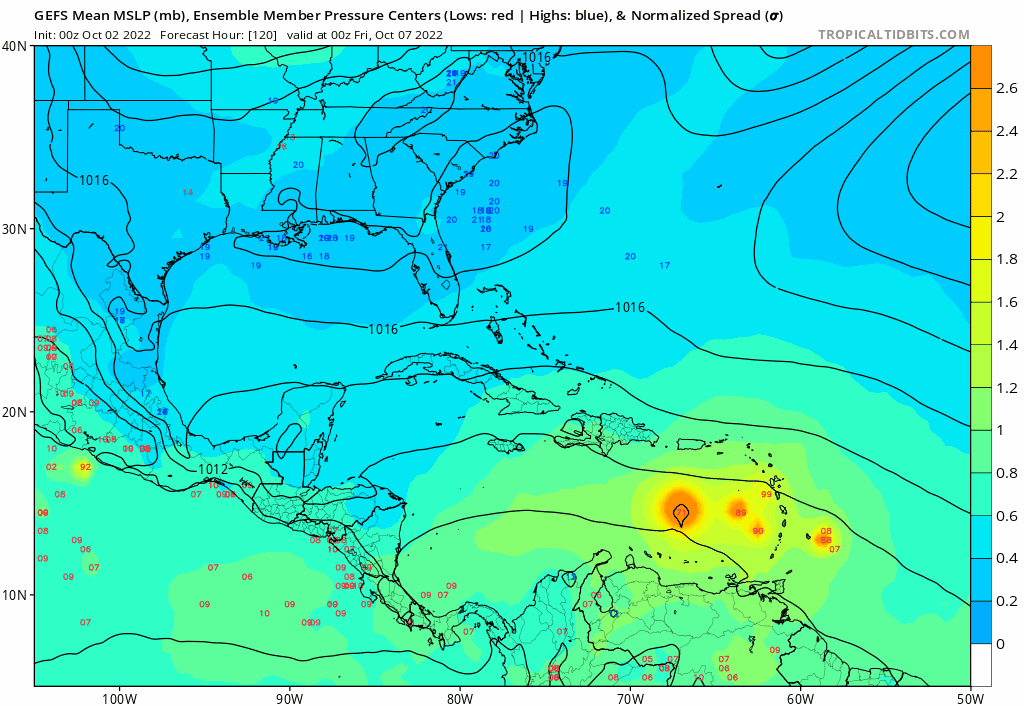
6z GFS with a sharp wave into the Caribbean. Given how much models underdid Fiona and Ian, this could be another situation where nowcasting is required.
5 likes
-
weeniepatrol
- Category 5
- Posts: 1345
- Joined: Sat Aug 22, 2020 5:30 pm
- Location: WA State
-
weeniepatrol
- Category 5
- Posts: 1345
- Joined: Sat Aug 22, 2020 5:30 pm
- Location: WA State
Re: Tropical Wave in Central Atlantic
Robust divergence aloft as anticyclonic outflow initiates. Strong poleward channel setting up, aided by an upper low to the NW
3 likes
-
cycloneye
- Admin
- Posts: 149715
- Age: 69
- Joined: Thu Oct 10, 2002 10:54 am
- Location: San Juan, Puerto Rico
Re: Tropical Wave in Central Atlantic
Here we go.
Central Tropical Atlantic:
Shower and thunderstorm activity associated with a tropical wave
located several hundred miles east of the Windward Islands has
increased over the past day or so. Some gradual development of the
wave is possible during the next few days while it moves generally
westward at 15 to 20 mph.
* Formation chance through 48 hours...low...10 percent.
* Formation chance through 5 days...low...20 percent.
4 likes
Visit the Caribbean-Central America Weather Thread where you can find at first post web cams,radars
and observations from Caribbean basin members Click Here
and observations from Caribbean basin members Click Here
-
Stormybajan

- Category 1

- Posts: 453
- Joined: Thu May 20, 2021 3:21 pm
- Location: Windward Islands
Re: Tropical Wave in Central Atlantic
I said evening or night for this large wave to be marked but NHC didnt stall and it now has a 10-20 % chance for development...lets see if GFS can reign supreme as the only model showing development! 
3 likes
Sad West Indies and Manchester United fan ⚽️
-
weeniepatrol
- Category 5
- Posts: 1345
- Joined: Sat Aug 22, 2020 5:30 pm
- Location: WA State

-
SFLcane

- S2K Supporter

- Posts: 10281
- Age: 48
- Joined: Sat Jun 05, 2010 1:44 pm
- Location: Lake Worth Florida
2022 Global Model Runs Discussion (Out thru day 16)
Impressive wave surely this morning it Might do something before going into Central America it seems.
0 likes
-
gatorcane

- S2K Supporter
- Posts: 23708
- Age: 48
- Joined: Sun Mar 13, 2005 3:54 pm
- Location: Boca Raton, FL
Re: Tropical Wave in Central Atlantic
Last edited by gatorcane on Sun Oct 02, 2022 7:13 am, edited 2 times in total.
0 likes
-
Category5Kaiju

- Category 5
- Posts: 4346
- Joined: Thu Dec 24, 2020 12:45 pm
- Location: Seattle during the summer, Phoenix during the winter
Re: 2022 Global Model Runs Discussion (Out thru day 16)
SFLcane wrote:Impressive wave surely this morning it Might do something before going into Central America it seems.
Much to my dismay, I regret to inform you that while yes it could crash into Central America, quite a few GEFS members take this thing northward and into…yup, poor Florida.
2 likes
Unless explicitly stated, all information in my posts is based on my own opinions and observations. Tropical storms and hurricanes can be extremely dangerous. Refer to an accredited weather research agency or meteorologist if you need to make serious decisions regarding an approaching storm.
-
Hurricaneman

- Category 5
- Posts: 7404
- Age: 45
- Joined: Tue Aug 31, 2004 3:24 pm
- Location: central florida
Re: Tropical Wave in Central Atlantic
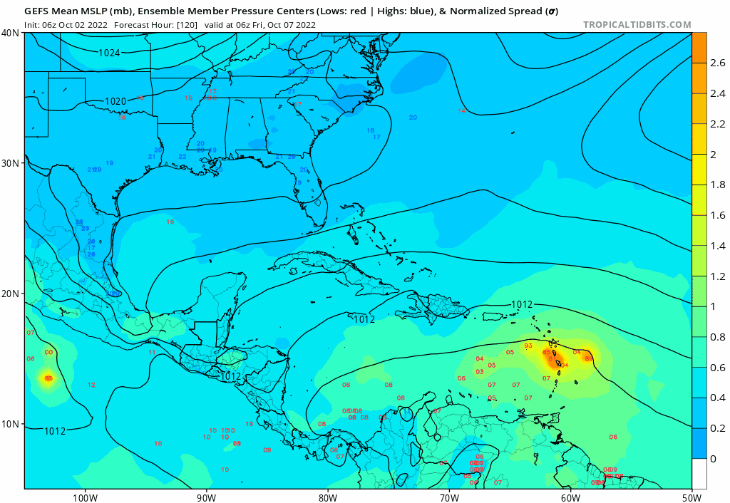
Ensembles of the GFS are interesting, something the west coast of Florida doesn’t need but there also seems to be equally weighted towards Central America
The Euro and it’s ensembles are all into Central America but as we all know early on the biases in the models and all we can do is keep an eye on it
The Euro and it’s ensembles are all into Central America but as we all know early on the biases in the models and all we can do is keep an eye on it
0 likes
-
SFLcane
- S2K Supporter
- Posts: 10281
- Age: 48
- Joined: Sat Jun 05, 2010 1:44 pm
- Location: Lake Worth Florida
Re: 2022 Global Model Runs Discussion (Out thru day 16)
Category5Kaiju wrote:SFLcane wrote:Impressive wave surely this morning it Might do something before going into Central America it seems.
Much to my dismay, I regret to inform you that while yes it could crash into Central America, quite a few GEFS members take this thing northward and into…yup, poor Florida.
06z seems to have more into Central America but yea we’ll see. Surely something to keep an eye on. It might do something and stay south of conus based on eps.
0 likes
-
Hurricaneman
- Category 5
- Posts: 7404
- Age: 45
- Joined: Tue Aug 31, 2004 3:24 pm
- Location: central florida
Re: 2022 Global Model Runs Discussion (Out thru day 16)
SFLcane wrote:Category5Kaiju wrote:SFLcane wrote:Impressive wave surely this morning it Might do something before going into Central America it seems.
Much to my dismay, I regret to inform you that while yes it could crash into Central America, quite a few GEFS members take this thing northward and into…yup, poor Florida.
06z seems to have more into Central America but yea we’ll see. Surely something to keep an eye on. It might do something and stay south of conus based on eps.
Also as we know the Euro for west moving tropical systems it tends to overdo ridges while the GFS likes to plow through ridges so we’ll see
4 likes
-
gatorcane
- S2K Supporter
- Posts: 23708
- Age: 48
- Joined: Sun Mar 13, 2005 3:54 pm
- Location: Boca Raton, FL
Re: Tropical Wave in Central Atlantic
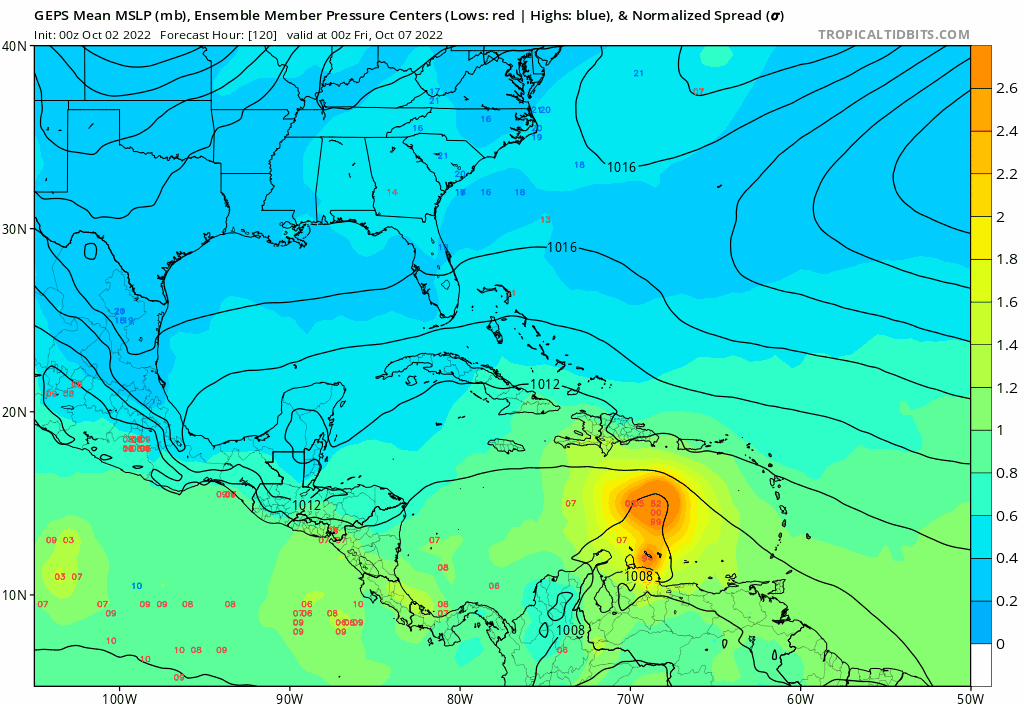
GEM ensembles. Most got into CA but some recurve into Florida. Strong signal:
1 likes

Re: Tropical Wave in Central Atlantic
Right now the operational models aren’t particularly thrilled with this wave. The GFS’ ghost vorticity bias might be part of the reason, and the magical vorticity it spins up in the Caribbean is interfering with the true vorticity from this wave. Let’s see if this can keep its impressive convection throughout the day and if the operational models start getting as excited as the ensembles.
0 likes
Irene '11 Sandy '12 Hermine '16 5/15/2018 Derecho Fay '20 Isaias '20 Elsa '21 Henri '21 Ida '21
I am only a meteorology enthusiast who knows a decent amount about tropical cyclones. Look to the professional mets, the NHC, or your local weather office for the best information.
I am only a meteorology enthusiast who knows a decent amount about tropical cyclones. Look to the professional mets, the NHC, or your local weather office for the best information.
-
tropicwatch

- Category 5
- Posts: 3427
- Age: 62
- Joined: Sat Jun 02, 2007 10:01 am
- Location: The Villages, Florida
- Contact:
Re: Tropical Wave in Central Atlantic
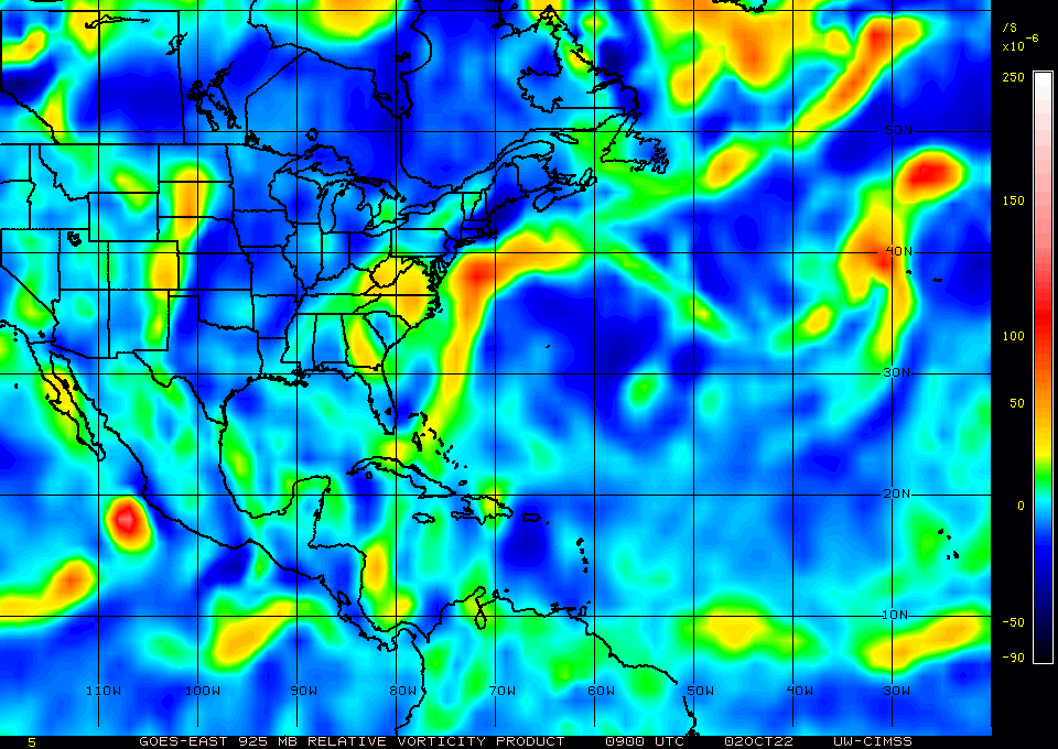
925mb vorticity is increasing. If convection maintains, I think we will see an increase in development chances this afternoon.
0400
0700
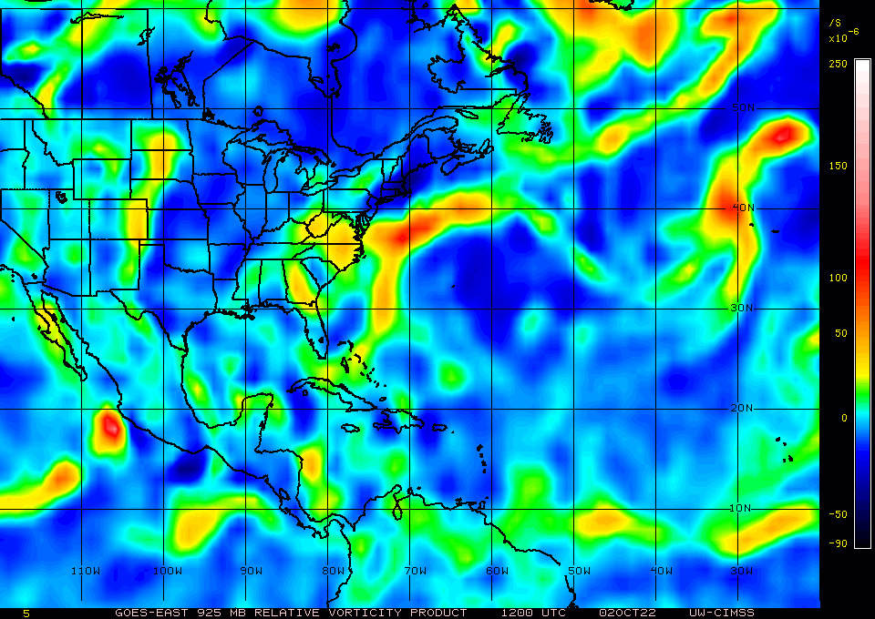
0400
0700
0 likes
Tropicwatch
Agnes 72', Eloise 75, Elena 85', Kate 85', Charley 86', Florence 88', Beryl 94', Dean 95', Erin 95', Opal 95', Earl 98', Georges 98', Ivan 2004', Arlene 2005', Dennis 2005', Ida 2009' Debby 2012' Irma 2017' Michael 2018'
Agnes 72', Eloise 75, Elena 85', Kate 85', Charley 86', Florence 88', Beryl 94', Dean 95', Erin 95', Opal 95', Earl 98', Georges 98', Ivan 2004', Arlene 2005', Dennis 2005', Ida 2009' Debby 2012' Irma 2017' Michael 2018'
-
cycloneye
- Admin
- Posts: 149715
- Age: 69
- Joined: Thu Oct 10, 2002 10:54 am
- Location: San Juan, Puerto Rico
Re: Tropical Wave in Central Atlantic
tropicwatch wrote:925mb vorticity is increasing. If convection maintains, I think we will see an increase in development chances this afternoon.
0400
https://tropicwatch.info/0400vor1001.jpg
0700
https://tropicwatch.info/070010022022.jpg
And the invest tag.
6 likes
Visit the Caribbean-Central America Weather Thread where you can find at first post web cams,radars
and observations from Caribbean basin members Click Here
and observations from Caribbean basin members Click Here
-
cycloneye
- Admin
- Posts: 149715
- Age: 69
- Joined: Thu Oct 10, 2002 10:54 am
- Location: San Juan, Puerto Rico
Re: Tropical Wave in Central Atlantic

6 likes
Visit the Caribbean-Central America Weather Thread where you can find at first post web cams,radars
and observations from Caribbean basin members Click Here
and observations from Caribbean basin members Click Here
Who is online
Users browsing this forum: No registered users and 202 guests