EPAC: ORLENE - Remnants
Moderator: S2k Moderators

Re: EPAC: ORLENE - Hurricane
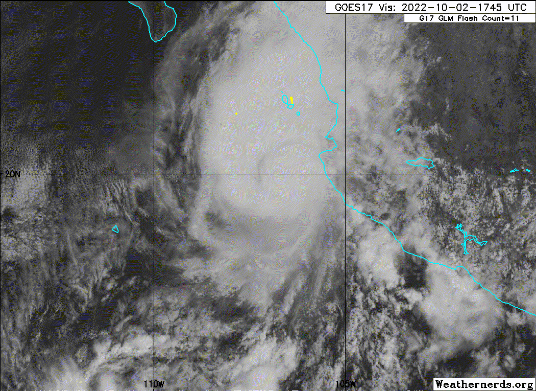
Nice blow up trying to wrap around the center.
0 likes
Personal Forecast Disclaimer:
The posts in this forum are NOT official forecast and should not be used as such. They are just the opinion of the poster and may or may not be backed by sound meteorological data. For official information, please refer to the NHC and NWS products.
The posts in this forum are NOT official forecast and should not be used as such. They are just the opinion of the poster and may or may not be backed by sound meteorological data. For official information, please refer to the NHC and NWS products.
-
cycloneye

- Admin

- Posts: 149727
- Age: 69
- Joined: Thu Oct 10, 2002 10:54 am
- Location: San Juan, Puerto Rico
Re: EPAC: ORLENE - Hurricane
Hurricane Orlene Discussion Number 17
NWS National Hurricane Center Miami FL EP162022
300 PM MDT Sun Oct 02 2022
Although the satellite presentation of Orlene is not as impressive
as it was overnight, the center is still embedded within an area of
cloud top temperatures of -70 to -80 degrees Celsius. The eye is
also not as defined in conventional satellite imagery as earlier
today, but an Air Force Force Reserve reconnaissance aircraft that
made two passes through the center earlier this afternoon reported
a closed 22 n-mi-wide eye on its final pass. The aircraft measured
a peak 700-mb flight-level wind of 96 kt, and SFMR winds of 92 kt.
Since the plane only made a couple passes through the eastern
eyewall, the intensity is set at 100 kt, owing to some
undersampling.
It has been difficult to determine if today's weakening was caused
by an eyewall replacement cycle, the increase in southwesterly
shear, or a combination of both. Regardless, southwesterly
vertical wind shear is forecast to increase during the next 12 to
24 hours, which is expected to cause an additional reduction in
wind speed, plus the entrainment of some drier mid-level air to the
west of Orlene. Orlene still is forecast to pass near or over the
Islas Marias as a strong hurricane tonight, and reach the coast of
mainland Mexico as a hurricane by on Monday. After landfall, rapid
weakening is expected, and the low-level center should dissipate
over the mountainous terrain of southwestern Mexico in 48-60 hours.
Satellite imagery and fixes from the aircraft show that Orlene is
still moving northward or 005/7 kt. The track forecast philosophy
is unchanged from before. Orlene should bend north-northeastward
tonight as it is steered between a mid-level ridge to its east and
a broad trough over northwestern Mexico. The track guidance is in
much better agreement this cycle, and the NHC forecast was only
nudged slightly westward to be closer to the various consensus
aids.
The updated track and wind radii forecast has necessitated the
issuance of a Tropical Storm Warning along the coast of mainland
Mexico to the northwest of the Hurricane Warning area. No other
changes were made to the existing wind warnings.
Key Messages:
1. Hurricane conditions are expected in the Islas Marias tonight,
with tropical storm conditions beginning within the next few hours.
A Hurricane Warning is in effect for a portion of west-central
mainland Mexico, where hurricane conditions are expected on Monday
with tropical storm conditions beginning late tonight. Preparations
to protect life and property should be rushed to completion.
2. A dangerous storm surge is likely to cause coastal flooding in
the Islas Marias and along the coast of mainland Mexico in the
warning area in regions of onshore winds.
3. Heavy rainfall from Orlene is expected to lead to flash flooding,
as well as possible landslides in areas of rugged terrain of
southwest Mexico through Tuesday.
FORECAST POSITIONS AND MAX WINDS
INIT 02/2100Z 20.4N 106.9W 100 KT 115 MPH
12H 03/0600Z 21.4N 106.7W 90 KT 105 MPH
24H 03/1800Z 22.4N 106.3W 80 KT 90 MPH
36H 04/0600Z 23.3N 105.8W 45 KT 50 MPH...INLAND
48H 04/1800Z 24.2N 105.3W 25 KT 30 MPH...INLAND
60H 05/0600Z...DISSIPATED
0 likes
Visit the Caribbean-Central America Weather Thread where you can find at first post web cams,radars
and observations from Caribbean basin members Click Here
and observations from Caribbean basin members Click Here
-
Sciencerocks
- Category 5

- Posts: 10193
- Age: 40
- Joined: Thu Jul 06, 2017 1:51 am
-
Sciencerocks
- Category 5
- Posts: 10193
- Age: 40
- Joined: Thu Jul 06, 2017 1:51 am
-
cycloneye
- Admin
- Posts: 149727
- Age: 69
- Joined: Thu Oct 10, 2002 10:54 am
- Location: San Juan, Puerto Rico
Re: EPAC: ORLENE - Hurricane
BULLETIN
Hurricane Orlene Intermediate Advisory Number 17A
NWS National Hurricane Center Miami FL EP162022
600 PM MDT Sun Oct 02 2022
...ORLENE NEARING ISLAS MARIAS...
...SIGNIFICANT WINDS AND DANGEROUS STORM SURGE LIKELY TO BEGIN
SHORTLY...
SUMMARY OF 600 PM MDT...0000 UTC...INFORMATION
----------------------------------------------
LOCATION...20.9N 106.8W
ABOUT 80 MI...125 KM WNW OF CABO CORRIENTES MEXICO
ABOUT 50 MI...80 KM SSW OF LAS ISLAS MARIAS MEXICO
MAXIMUM SUSTAINED WINDS...115 MPH...185 KM/H
PRESENT MOVEMENT...N OR 5 DEGREES AT 8 MPH...13 KM/H
MINIMUM CENTRAL PRESSURE...972 MB...28.71 INCHES
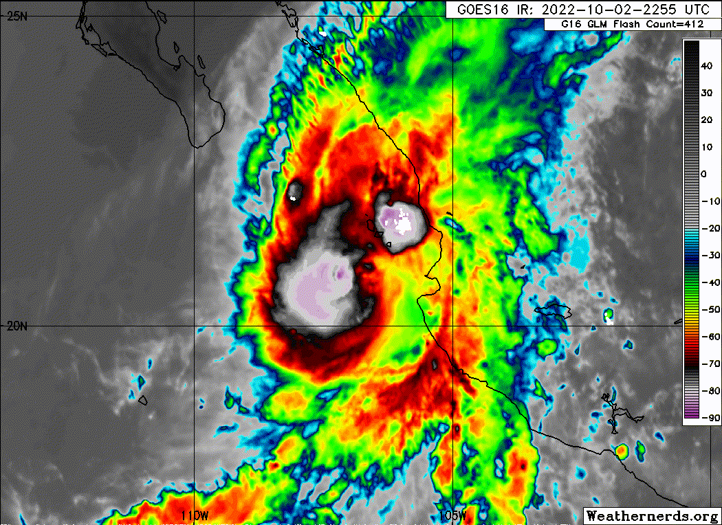
Hurricane Orlene Discussion Number 18
NWS National Hurricane Center Miami FL EP162022
900 PM MDT Sun Oct 02 2022
Orlene appears to be slowly weakening this evening. 1-minute GOES-17
IR satellite imagery shows persistent bursting cloud tops below -80
C in the northern semicircle of the hurricane, likely still
associated with its eyewall. A 0116 UTC F-17 SSMIS microwave pass
also showed an eyewall fragment remains in connection to these very
cold cloud tops, though comparing microwave with geostationary
satellite suggests the hurricane is starting to become more tilted.
There are also subtle hints that upper-level westerly flow is
beginning to undercut the cirrus on the western side of the
convective plume. The subjective Dvorak intensity estimates were CI
5.5/102-kt from TAFB and CI 5.0/90-kt from SAB. However, the Final
T-numbers have been slowly decreasing and the initial intensity was
set to 90 kt for this advisory.
The intensity forecast is somewhat tricky for Orlene over the next
day or so. Deep-layer (200-850 mb) southwesterly vertical wind shear
is steadily increasing over Orlene and is now over 20-kt in both the
latest GFS- and ECMWF-based SHIPS guidance. This shear is expected
to increase to 30-kt in the next 12-24 h, and will likely play a
role in helping to import drier mid-level air into the core of the
small hurricane. However, during this period, Orlene will also be
traversing over very warm sea-surface temperatures, above 30 degrees
Celsius, which could help the deep convection to remain quite
vigorous, especially during the diurnal max period. Thus, while
weakening appears likely, the rate of weakening has a higher than
normal uncertainty. The intensity guidance this cycle has a faster
rate of weakening, and the latest NHC intensity forecast was
shifted in that direction, though not quite as dramatic. Orlene is
still forecast to be a hurricane as it makes landfall in mainland
Mexico sometime on Monday. After landfall, the small system should
quickly weaken over the higher terrain of Mexico, with dissipation
likely by 48 hours.
The hurricane appears to be moving a little more east of due north
tonight, with the estimated motion at 010/7 kt. Orlene should
continue this general heading for the next 12 to 24 hours, remaining
steered by a mid-level ridge to its east, until the hurricane makes
landfall at some point on Monday along the southwestern coast of
Mexico. The track guidance this cycle has made a shift to the west,
likely due to some of the guidance (GFS, HWRF) showing the tropical
cyclone de-coupling from the deep convection in the immediate
short-term. Since that process has not yet occurred, the track
forecast this cycle was only shifted slightly west of the prior
track, though is notably slower with the speed of Orlene shortly
after the system makes landfall.
Key Messages:
1. Hurricane conditions are likely ongoing near Islas Marias
tonight. A Hurricane Warning is in effect for a portion of
west-central mainland Mexico, where hurricane conditions are
expected on Monday with tropical storm conditions beginning
overnight. Preparations to protect life and property should be
rushed to completion.
2. A dangerous storm surge is likely to cause coastal flooding in
the Islas Marias and along the coast of mainland Mexico in the
warning area in regions of onshore winds.
3. Heavy rainfall from Orlene is expected to lead to flash flooding,
as well as possible landslides in areas of rugged terrain of
southwest Mexico through Tuesday.
FORECAST POSITIONS AND MAX WINDS
INIT 03/0300Z 21.4N 106.5W 90 KT 105 MPH
12H 03/1200Z 22.1N 106.4W 80 KT 90 MPH
24H 04/0000Z 22.9N 106.2W 70 KT 80 MPH...ON THE COAST OF MEXICO
36H 04/1200Z 23.6N 105.9W 35 KT 40 MPH...INLAND
48H 05/0000Z...DISSIPATED
$$
Forecaster Papin/Blake
Hurricane Orlene Intermediate Advisory Number 17A
NWS National Hurricane Center Miami FL EP162022
600 PM MDT Sun Oct 02 2022
...ORLENE NEARING ISLAS MARIAS...
...SIGNIFICANT WINDS AND DANGEROUS STORM SURGE LIKELY TO BEGIN
SHORTLY...
SUMMARY OF 600 PM MDT...0000 UTC...INFORMATION
----------------------------------------------
LOCATION...20.9N 106.8W
ABOUT 80 MI...125 KM WNW OF CABO CORRIENTES MEXICO
ABOUT 50 MI...80 KM SSW OF LAS ISLAS MARIAS MEXICO
MAXIMUM SUSTAINED WINDS...115 MPH...185 KM/H
PRESENT MOVEMENT...N OR 5 DEGREES AT 8 MPH...13 KM/H
MINIMUM CENTRAL PRESSURE...972 MB...28.71 INCHES
Hurricane Orlene Discussion Number 18
NWS National Hurricane Center Miami FL EP162022
900 PM MDT Sun Oct 02 2022
Orlene appears to be slowly weakening this evening. 1-minute GOES-17
IR satellite imagery shows persistent bursting cloud tops below -80
C in the northern semicircle of the hurricane, likely still
associated with its eyewall. A 0116 UTC F-17 SSMIS microwave pass
also showed an eyewall fragment remains in connection to these very
cold cloud tops, though comparing microwave with geostationary
satellite suggests the hurricane is starting to become more tilted.
There are also subtle hints that upper-level westerly flow is
beginning to undercut the cirrus on the western side of the
convective plume. The subjective Dvorak intensity estimates were CI
5.5/102-kt from TAFB and CI 5.0/90-kt from SAB. However, the Final
T-numbers have been slowly decreasing and the initial intensity was
set to 90 kt for this advisory.
The intensity forecast is somewhat tricky for Orlene over the next
day or so. Deep-layer (200-850 mb) southwesterly vertical wind shear
is steadily increasing over Orlene and is now over 20-kt in both the
latest GFS- and ECMWF-based SHIPS guidance. This shear is expected
to increase to 30-kt in the next 12-24 h, and will likely play a
role in helping to import drier mid-level air into the core of the
small hurricane. However, during this period, Orlene will also be
traversing over very warm sea-surface temperatures, above 30 degrees
Celsius, which could help the deep convection to remain quite
vigorous, especially during the diurnal max period. Thus, while
weakening appears likely, the rate of weakening has a higher than
normal uncertainty. The intensity guidance this cycle has a faster
rate of weakening, and the latest NHC intensity forecast was
shifted in that direction, though not quite as dramatic. Orlene is
still forecast to be a hurricane as it makes landfall in mainland
Mexico sometime on Monday. After landfall, the small system should
quickly weaken over the higher terrain of Mexico, with dissipation
likely by 48 hours.
The hurricane appears to be moving a little more east of due north
tonight, with the estimated motion at 010/7 kt. Orlene should
continue this general heading for the next 12 to 24 hours, remaining
steered by a mid-level ridge to its east, until the hurricane makes
landfall at some point on Monday along the southwestern coast of
Mexico. The track guidance this cycle has made a shift to the west,
likely due to some of the guidance (GFS, HWRF) showing the tropical
cyclone de-coupling from the deep convection in the immediate
short-term. Since that process has not yet occurred, the track
forecast this cycle was only shifted slightly west of the prior
track, though is notably slower with the speed of Orlene shortly
after the system makes landfall.
Key Messages:
1. Hurricane conditions are likely ongoing near Islas Marias
tonight. A Hurricane Warning is in effect for a portion of
west-central mainland Mexico, where hurricane conditions are
expected on Monday with tropical storm conditions beginning
overnight. Preparations to protect life and property should be
rushed to completion.
2. A dangerous storm surge is likely to cause coastal flooding in
the Islas Marias and along the coast of mainland Mexico in the
warning area in regions of onshore winds.
3. Heavy rainfall from Orlene is expected to lead to flash flooding,
as well as possible landslides in areas of rugged terrain of
southwest Mexico through Tuesday.
FORECAST POSITIONS AND MAX WINDS
INIT 03/0300Z 21.4N 106.5W 90 KT 105 MPH
12H 03/1200Z 22.1N 106.4W 80 KT 90 MPH
24H 04/0000Z 22.9N 106.2W 70 KT 80 MPH...ON THE COAST OF MEXICO
36H 04/1200Z 23.6N 105.9W 35 KT 40 MPH...INLAND
48H 05/0000Z...DISSIPATED
$$
Forecaster Papin/Blake
0 likes
Visit the Caribbean-Central America Weather Thread where you can find at first post web cams,radars
and observations from Caribbean basin members Click Here
and observations from Caribbean basin members Click Here
-
Yellow Evan

- Professional-Met

- Posts: 16257
- Age: 27
- Joined: Fri Jul 15, 2011 12:48 pm
- Location: Henderson, Nevada/Honolulu, HI
- Contact:
Re: EPAC: ORLENE - Hurricane
TXPZ28 KNES 030547
TCSENP
A. 16E (ORLENE)
B. 03/0530Z
C. 21.7N
D. 106.3W
E. THREE/GOES-W
F. T4.0/4.5
G. IR/EIR/SWIR/SSMIS
H. REMARKS...LLCC EMBEDDED IN MG RESULTS IN A DT OF 4.0. MET AND PT
ARE ALSO 4.0 BASED ON A RAPID 24-HOUR WEAKENING TREND. THE FT IS BASED
ON THE MET DUE TO UNCERTAINTY IN CENTER LOCATION.
I. ADDL POSITIONS
03/0116Z 21.2N 106.7W SSMIS
...CLARK
0 likes
-
Yellow Evan
- Professional-Met
- Posts: 16257
- Age: 27
- Joined: Fri Jul 15, 2011 12:48 pm
- Location: Henderson, Nevada/Honolulu, HI
- Contact:
Re: EPAC: ORLENE - Hurricane
787
WTPZ31 KNHC 030555
TCPEP1
BULLETIN
Hurricane Orlene Intermediate Advisory Number 18A
NWS National Hurricane Center Miami FL EP162022
1200 AM MDT Mon Oct 03 2022
...ORLENE CAUSING HURRICANE CONDITIONS IN LAS ISLAS MARIAS
ISLANDS...
...EXPECTED TO BRING STRONG WINDS AND A DANGEROUS STORM SURGE TO
PORTIONS OF WESTERN MAINLAND MEXICO...
SUMMARY OF 1200 AM MDT...0600 UTC...INFORMATION
-----------------------------------------------
LOCATION...21.7N 106.5W
ABOUT 15 MI...25 KM N OF LAS ISLAS MARIAS MEXICO
MAXIMUM SUSTAINED WINDS...105 MPH...165 KM/H
PRESENT MOVEMENT...N OR 10 DEGREES AT 8 MPH...13 KM/H
MINIMUM CENTRAL PRESSURE...976 MB...28.82 INCHES
WATCHES AND WARNINGS
--------------------
CHANGES WITH THIS ADVISORY:
None.
SUMMARY OF WATCHES AND WARNINGS IN EFFECT:
A Hurricane Warning is in effect for...
* Las Islas Marias
* The coast of mainland Mexico from San Blas to Mazatlan
A Tropical Storm Warning is in effect for...
* The coast of mainland Mexico from Playa Perula to San Blas
* The coast of mainland Mexico from north of Mazatlan to Bahia
Tempehuaya
A Hurricane Watch is in effect for...
* The coast of mainland Mexico from Playa Perula to San Blas
* The coast of mainland Mexico from Mazatlan to Bahia Tempehuaya
A Hurricane Warning means that hurricane conditions are expected
somewhere within the warning area. Preparations to protect life
and property should be rushed to completion.
A Tropical Storm Warning means that tropical storm conditions are
expected somewhere within the warning area, generally within 36
hours.
A Hurricane Watch means that hurricane conditions are possible
within the watch area.
Interests elsewhere along the coast of western and northwestern
Mexico should monitor the progress of Orlene.
For storm information specific to your area, please monitor
products issued by your national meteorological service.
DISCUSSION AND OUTLOOK
----------------------
At 1200 AM MDT (0600 UTC), the center of Hurricane Orlene was
located near latitude 21.7 North, longitude 106.5 West. Orlene is
moving toward the north near 8 mph (13 km/h), and a general
northward to north-northeastward motion is expected to continue over
the next day or so. On the forecast track, the center of Orlene
will be moving away from Las Islas Marias this morning, and reach
the coast of mainland Mexico within the warning area later today or
tonight.
Maximum sustained winds are near 105 mph (165 km/h) with higher
gusts. Weakening is expected during the next day or so, but Orlene
is forecast to be remain a hurricane when it reaches southwestern
Mexico. Rapid weakening is forecast after Orlene moves onshore, and
the system should dissipate on Tuesday.
Hurricane-force winds extend outward up to 15 miles (30 km) from
the center and tropical-storm-force winds extend outward up to 90
miles (150 km). Isla Maria Madre reported a sustained wind of 67
mph (107 km/h) with a gust to 92 mph (148 km/h).
The estimated minimum central pressure is 976 mb (28.82 inches).
HAZARDS AFFECTING LAND
----------------------
WIND: Hurricane conditions are expected in Las Islas Marias for the
next several hours. Hurricane conditions are expected in the
warning area along the coast of mainland Mexico today, with
tropical storm conditions beginning this morning.
Tropical storm conditions are expected to spread northward in the
tropical storm warning area through early today. Hurricane
conditions are possible along the coast of mainland Mexico within
the hurricane watch area early today.
RAINFALL: Orlene is expected to produce the following rainfall
across portions of southwestern Mexico through Tuesday:
* Islas Marias: 6 to 10 inches, with local amounts of 14 inches.
* Nayarit and southern Sinaloa: 3 to 6 inches with local amounts of
10 inches.
* Jalisco, Colima, and southwest Durango: 1 to 3 inches with local
amounts of 5 inches.
These rainfall amounts are likely to lead to flash flooding, as
well as possible landslides in areas of rugged terrain.
STORM SURGE: A dangerous storm surge is likely to cause coastal
flooding in the Islas Marias and along the coast of mainland Mexico
in the warning area in regions of onshore winds.
SURF: Large swells generated by Orlene are affecting the west coast
of Mexico and will spread northward to the southern portion of the
Baja California peninsula and the Gulf of California over the next
day or so. These swells are likely to cause life-threatening surf
and rip current conditions. Please consult products from your local
weather office.
NEXT ADVISORY
-------------
Next complete advisory at 300 AM MDT.
$$
Forecaster Pasch
0 likes
-
cycloneye
- Admin
- Posts: 149727
- Age: 69
- Joined: Thu Oct 10, 2002 10:54 am
- Location: San Juan, Puerto Rico
Re: EPAC: ORLENE - Hurricane
BULLETIN
Hurricane Orlene Advisory Number 19
NWS National Hurricane Center Miami FL EP162022
300 AM MDT Mon Oct 03 2022
...ORLENE EXPECTED TO BRING STRONG WINDS AND A DANGEROUS STORM
SURGE TO PORTIONS OF WESTERN MAINLAND MEXICO LATER TODAY...
SUMMARY OF 300 AM MDT...0900 UTC...INFORMATION
----------------------------------------------
LOCATION...22.1N 106.4W
ABOUT 75 MI...120 KM S OF MAZATLAN MEXICO
MAXIMUM SUSTAINED WINDS...100 MPH...155 KM/H
PRESENT MOVEMENT...N OR 10 DEGREES AT 9 MPH...15 KM/H
MINIMUM CENTRAL PRESSURE...976 MB...28.82 INCHES
Hurricane Orlene Discussion Number 19
NWS National Hurricane Center Miami FL EP162022
300 AM MDT Mon Oct 03 2022
Orlene's cloud pattern has been becoming less organized, likely due
to the influence of strong southwesterly shear associated with a
broad upper-level trough near Baja California. Inner-core
convection has been gradually diminishing, but there are still some
strong convective bands around the center. Upper-level outflow is
restricted over the western portion of the circulation as a
result of the shear. The current intensity estimate is set to 85
kt based on a blend of subjective and objective Dvorak T-numbers,
but is more uncertain than usual.
Although the unfavorable shear should continue to affect the
cyclone, Orlene will moving over very warm waters today which
should help the system maintain some of its intensity up to
landfall. The Decay-SHIPS model guidance indicates that Orlene
will still be a hurricane when it makes landfall later today, and
the official forecast shows this as well. After Orlene makes
landfall, the small cyclone is likely to quickly weaken over the
mountainous terrain of Mexico, and it should dissipate within 1-2
days.
Orlene continues to move just east of due north with an estimated
initial motion of 010/8 kt. There is basically no change to the
track forecast reasoning. The system should continue to be steered
by the flow on the western side of a mid-level ridge until it makes
landfall on the coast of Mexico within the Hurricane Warning area
in less than a day. The official track forecast is similar to the
previous NHC prediction and is roughly in the middle of the fairly
tightly clustered dynamical track guidance envelope.
Key Messages:
1. A Hurricane Warning is in effect for a portion of west-central
mainland Mexico, where hurricane conditions are expected later
today with tropical storm conditions beginning this morning.
Preparations to protect life and property should be rushed to
completion.
2. A dangerous storm surge is likely to cause flooding along
the coast of mainland Mexico in the warning area in regions of
onshore winds.
3. Heavy rainfall from Orlene is expected to lead to flash flooding,
as well as possible landslides in areas of rugged terrain of
southwest Mexico through Tuesday.
FORECAST POSITIONS AND MAX WINDS
INIT 03/0900Z 22.1N 106.4W 85 KT 100 MPH
12H 03/1800Z 22.9N 106.2W 75 KT 85 MPH
24H 04/0600Z 23.5N 106.0W 40 KT 45 MPH...INLAND
36H 04/1800Z 24.0N 106.0W 20 KT 25 MPH...POST-TROP/INLAND
48H 05/0600Z...DISSIPATED
$$
Forecaster Pasch
0 likes
Visit the Caribbean-Central America Weather Thread where you can find at first post web cams,radars
and observations from Caribbean basin members Click Here
and observations from Caribbean basin members Click Here
-
cycloneye
- Admin
- Posts: 149727
- Age: 69
- Joined: Thu Oct 10, 2002 10:54 am
- Location: San Juan, Puerto Rico
Re: EPAC: ORLENE - Hurricane
Hurricane Orlene Tropical Cyclone Update
NWS National Hurricane Center Miami FL EP162022
745 AM MDT Mon Oct 02 2022
...ORLENE MAKES LANDFALL IN SOUTHWESTERN MEXICO...
Satellite imagery indicates that Orlene has made landfall in
southwest Mexico just north of the Nayarit and Sinaloa border around
745 AM MDT (1345 UTC). The maximum sustained winds are estimated to
be 85 mph (140 km/h), and the minimum central pressure is estimated
at 980 mb (28.94 inches).
An observing site at Marismas Nacionales near Felipe Angeles in the
state of Nayarit has recently reported sustained winds of 44 mph
(70 km/h) and a gust to 81 mph (130 km/h).
SUMMARY OF 745 AM MDT...1345 UTC...INFORMATION
----------------------------------------------
LOCATION...22.7N 105.9W
ABOUT 45 MI...75 KM SE OF MAZATLAN MEXICO
MAXIMUM SUSTAINED WINDS...85 MPH...140 KM/H
PRESENT MOVEMENT...NNE OR 015 DEGREES AT 10 MPH...17 KM/H
MINIMUM CENTRAL PRESSURE...980 MB...28.94 INCHES
$$
Forecaster Brown
0 likes
Visit the Caribbean-Central America Weather Thread where you can find at first post web cams,radars
and observations from Caribbean basin members Click Here
and observations from Caribbean basin members Click Here
-
wxman57

- Moderator-Pro Met

- Posts: 23175
- Age: 68
- Joined: Sat Jun 21, 2003 8:06 pm
- Location: Houston, TX (southwest)
Re: EPAC: ORLENE - Hurricane
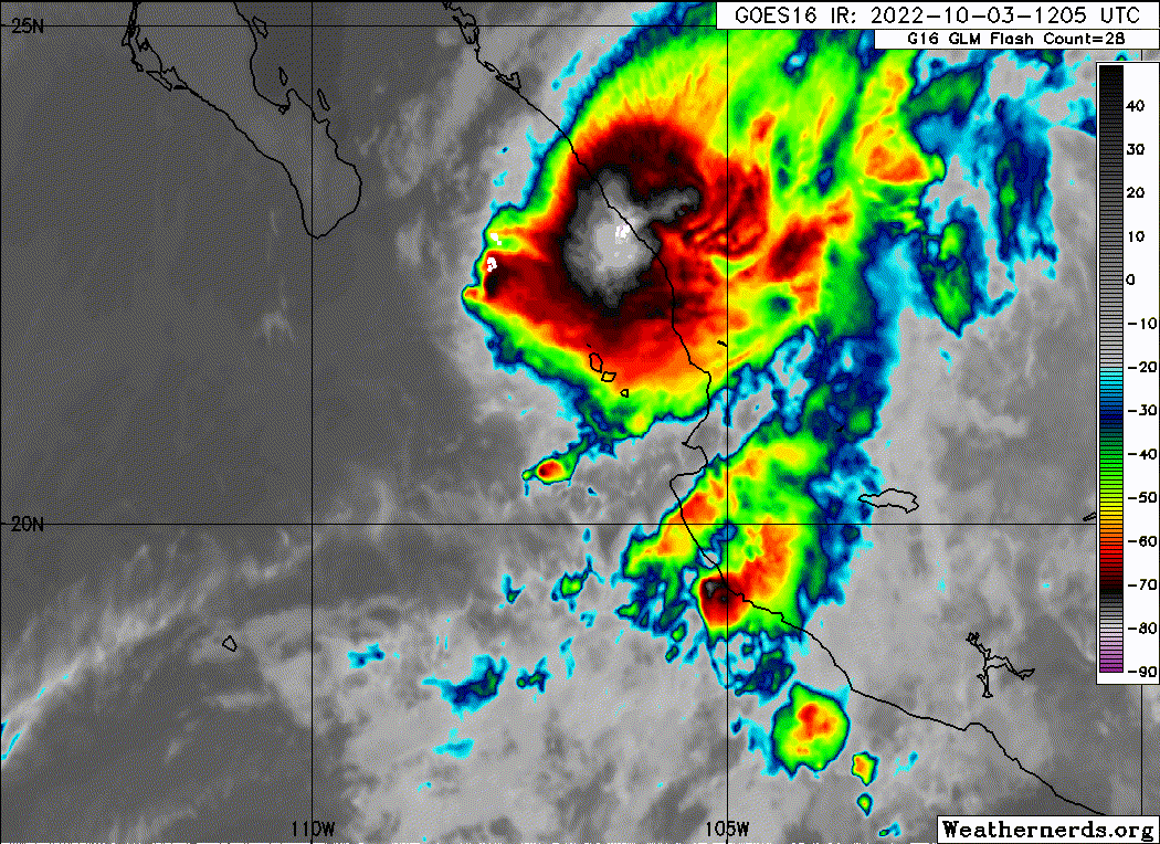
I am having a hard time even locating rotation with Orlene this morning. Looks like a mess.
0 likes
-
Sciencerocks
- Category 5
- Posts: 10193
- Age: 40
- Joined: Thu Jul 06, 2017 1:51 am
-
Yellow Evan
- Professional-Met
- Posts: 16257
- Age: 27
- Joined: Fri Jul 15, 2011 12:48 pm
- Location: Henderson, Nevada/Honolulu, HI
- Contact:
Re: EPAC: ORLENE - Hurricane
After holding together for a while, this really fell apart right before landfall and had the look of something not vertically staked.
0 likes
-
wxman57
- Moderator-Pro Met
- Posts: 23175
- Age: 68
- Joined: Sat Jun 21, 2003 8:06 pm
- Location: Houston, TX (southwest)
Re: EPAC: ORLENE - Hurricane
Orlene probably was not a hurricane at landfall. The Cabo San Lucas radar is over 200 miles away, it couldn't have been observing much that far out as the beam height was probably near 30,000 ft. I cannot find any rotation. Sierra Madres are near the coast there.
0 likes
-
Yellow Evan
- Professional-Met
- Posts: 16257
- Age: 27
- Joined: Fri Jul 15, 2011 12:48 pm
- Location: Henderson, Nevada/Honolulu, HI
- Contact:

Re: EPAC: ORLENE - Hurricane
0 likes
TC naming lists: retirements and intensity
Most aggressive Advisory #1's in North Atlantic (cr. kevin for starting the list)
Most aggressive Advisory #1's in North Atlantic (cr. kevin for starting the list)
-
ThunderForce

- Tropical Storm

- Posts: 208
- Age: 26
- Joined: Tue Sep 27, 2022 6:20 pm
- Location: Calhoun County, Florida
Re: EPAC: ORLENE - Hurricane

Why is Orlene still labeled a hurricane on the NHC's website when the maximum winds are below 75 MPH?
0 likes
Please refer to the NWS, NHC, SPC or a professional meteorologist for information and decision making during storms.
-
Sciencerocks
- Category 5
- Posts: 10193
- Age: 40
- Joined: Thu Jul 06, 2017 1:51 am
-
cycloneye
- Admin
- Posts: 149727
- Age: 69
- Joined: Thu Oct 10, 2002 10:54 am
- Location: San Juan, Puerto Rico
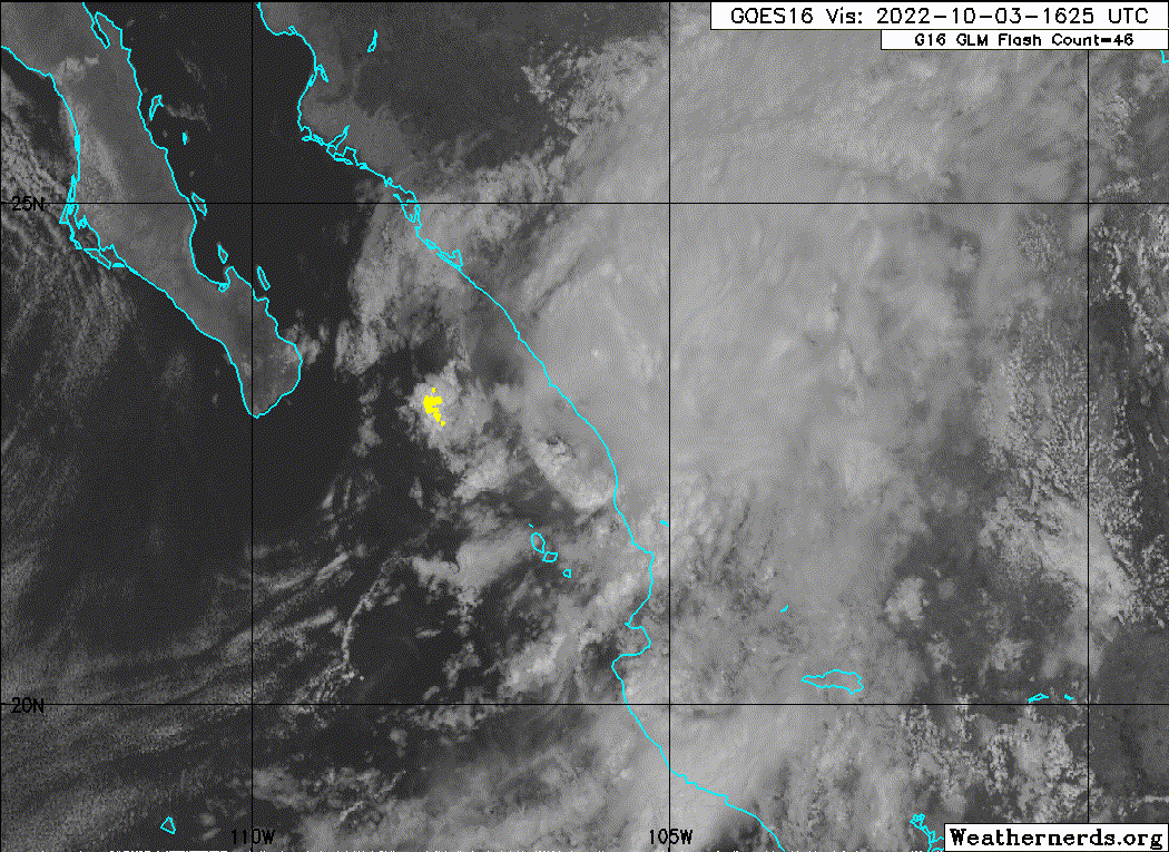
Re: EPAC: ORLENE - Tropical Depression
Tropical Depression Orlene Discussion Number 21
NWS National Hurricane Center Miami FL EP162022
400 PM CDT Mon Oct 03 2022
Strong west-southwesterly shear and the mountainous terrain of
southwestern Mexico have taken a toll on Orlene. The tropical
cyclone has rapidly weakened, and is now estimated to be a 30-kt
tropical depression. A long-loop of one-minute GOES-17 visible
satellite imagery suggests that the center likely came ashore
slightly west of the earlier track, but close to the estimated time.
Additional weakening is expected, and the low-level center is
likely to dissipate this evening. A 12-h point is provided for
continuity but Orlene is not likely to exist as a cyclone by that
time.
Orlene is moving north-northeastward or 025/9 kt. The cyclone or
its remnants should continue to move north-northeastward around the
northwestern periphery of a mid-level ridge until dissipation
occurs.
Key Messages:
1. Heavy rainfall from Orlene is expected to lead to flash flooding,
as well as possible landslides in areas of rugged terrain of
Southwest Mexico through Tuesday.
FORECAST POSITIONS AND MAX WINDS
INIT 03/2100Z 23.6N 105.4W 30 KT 35 MPH...INLAND
12H 04/0600Z 24.5N 104.8W 20 KT 25 MPH...POST-TROP/REMNT LOW
24H 04/1800Z...DISSIPATED
$$
Forecaster Brown
0 likes
Visit the Caribbean-Central America Weather Thread where you can find at first post web cams,radars
and observations from Caribbean basin members Click Here
and observations from Caribbean basin members Click Here
-
somethingfunny

- ChatStaff

- Posts: 3926
- Age: 37
- Joined: Thu May 31, 2007 10:30 pm
- Location: McKinney, Texas
Re: EPAC: ORLENE - Hurricane
wxman57 wrote:Orlene probably was not a hurricane at landfall. The Cabo San Lucas radar is over 200 miles away, it couldn't have been observing much that far out as the beam height was probably near 30,000 ft. I cannot find any rotation. Sierra Madres are near the coast there.
Thankfully we have data sources that were closer than 200 miles from the landfall location - Josh Morgerman intercepted the eye and reported everything you would expect to find from a legitimate hurricane landfall. Including hurricane force winds, a wind shift, and an eye.
4 likes
I am not a meteorologist, and any posts made by me are not official forecasts or to be interpreted as being intelligent. These posts are just my opinions and are probably silly opinions.
-
Yellow Evan
- Professional-Met
- Posts: 16257
- Age: 27
- Joined: Fri Jul 15, 2011 12:48 pm
- Location: Henderson, Nevada/Honolulu, HI
- Contact:
Re: EPAC: ORLENE - Tropical Depression
Tbf he didn’t explicitly measure hurricane force winds.
1 likes
Who is online
Users browsing this forum: No registered users and 51 guests