EPAC: JULIA - Models
Moderator: S2k Moderators
Re: ATL: INVEST 91L - Models
Along with the 12 runs of the UKMET, ICON, and GFS, the 12Z Euro has its strongest run yet with this with it landfalling in Nicaragua as a strong TS at 120. Also, the 12Z CMC has a H as earlier mentioned,
0 likes
Personal Forecast Disclaimer:
The posts in this forum are NOT official forecasts and should not be used as such. They are just the opinion of the poster and may or may not be backed by sound meteorological data. They are NOT endorsed by any professional institution or storm2k.org. For official information, please refer to the NHC and NWS products.
The posts in this forum are NOT official forecasts and should not be used as such. They are just the opinion of the poster and may or may not be backed by sound meteorological data. They are NOT endorsed by any professional institution or storm2k.org. For official information, please refer to the NHC and NWS products.


-
jlauderdal
- S2K Supporter

- Posts: 7240
- Joined: Wed May 19, 2004 5:46 am
- Location: NE Fort Lauderdale
- Contact:
Re: ATL: INVEST 91L - Models
SouthFLTropics wrote:Based on everything we are seeing I think that 91L is a shoe in for a Central America strike. With regard to any potential CONUS impacts, I think we will need to watch future model runs to see what the remnants do after and/or if it emerges back into the Bay of Campeche. The setup seems to be very much like Mitch 1998. Mitch did eventually emerge in the BOC and reform into a tropical storm before scooting ENE and crossing Florida. At least for the next 10 days, I think the GOM and Florida are closed for business. High pressure in control and beautiful weather here in South Florida today. Forecast looks good into next week.
Late start to the hurricane season, an early start to fall in South Florida. Lets see if the oddness continues but we have at least a month to go.
1 likes
-
gatorcane

- S2K Supporter
- Posts: 23708
- Age: 48
- Joined: Sun Mar 13, 2005 3:54 pm
- Location: Boca Raton, FL
Re: ATL: INVEST 91L - Models
2 likes
-
gatorcane
- S2K Supporter
- Posts: 23708
- Age: 48
- Joined: Sun Mar 13, 2005 3:54 pm
- Location: Boca Raton, FL
Re: ATL: INVEST 91L - Models
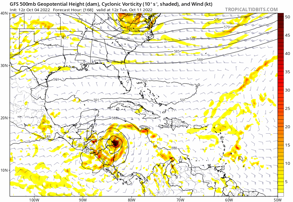
The GFS moves 91l the slowest of the three global models (Euro, CMC, and GFS). As a result the Gulf/Florida ridge has a chance to break down and the GFS spins off a piece of vorticity albeit sheared into the weakness to the NE. 500MB animation below:
1 likes
-
floridasun
- Tropical Storm

- Posts: 245
- Joined: Tue Sep 14, 2021 3:59 pm
Re: ATL: INVEST 91L - Models
so dont go toward central america??
0 likes
-
DESTRUCTION5

- Category 5

- Posts: 4430
- Age: 44
- Joined: Wed Sep 03, 2003 11:25 am
- Location: Stuart, FL
Re: ATL: INVEST 91L - Models
WTF. That's night and day from operationals.
0 likes
GATOR NATION IS E V E R Y W H E R E !

Re: ATL: INVEST 91L - Models
2 likes
TC naming lists: retirements and intensity
Most aggressive Advisory #1's in North Atlantic (cr. kevin for starting the list)
Most aggressive Advisory #1's in North Atlantic (cr. kevin for starting the list)

Re: ATL: INVEST 91L - Models
18z GFS should be completely disregarded. It wraps 91L within an imaginary gyre of convection across all of northern SA and spins up a magical ball of vorticity in the very SWCar.
The GFS’s Caribbean/SA vorticity bias really needs to be corrected.
The GFS’s Caribbean/SA vorticity bias really needs to be corrected.
4 likes
Irene '11 Sandy '12 Hermine '16 5/15/2018 Derecho Fay '20 Isaias '20 Elsa '21 Henri '21 Ida '21
I am only a meteorology enthusiast who knows a decent amount about tropical cyclones. Look to the professional mets, the NHC, or your local weather office for the best information.
I am only a meteorology enthusiast who knows a decent amount about tropical cyclones. Look to the professional mets, the NHC, or your local weather office for the best information.
-
cheezyWXguy

- Category 5
- Posts: 6282
- Joined: Mon Feb 13, 2006 12:29 am
- Location: Dallas, TX
Re: ATL: INVEST 91L - Models
aspen wrote:18z GFS should be completely disregarded. It wraps 91L within an imaginary gyre of convection across all of northern SA and spins up a magical ball of vorticity in the very SWCar.
The GFS’s Caribbean/SA vorticity bias really needs to be corrected.
Now THAT is a cag bias…
Edit to add: run might still be worth watching for the 500mb pattern. High across the gulf into the conus is a lot weaker and further east by 150hr. Literal track/intensity should be thrown out though
0 likes
-
gatorcane
- S2K Supporter
- Posts: 23708
- Age: 48
- Joined: Sun Mar 13, 2005 3:54 pm
- Location: Boca Raton, FL
Re: ATL: INVEST 91L - Models
The 18Z GFS shows this barely missing the weakness in the Gulf to the north. Also bombs if out in the NW Caribbean. 
3 likes
-
cycloneye

- Admin

- Posts: 149728
- Age: 69
- Joined: Thu Oct 10, 2002 10:54 am
- Location: San Juan, Puerto Rico
Re: ATL: INVEST 91L - Models
0 likes
Visit the Caribbean-Central America Weather Thread where you can find at first post web cams,radars
and observations from Caribbean basin members Click Here
and observations from Caribbean basin members Click Here

Re: ATL: INVEST 91L - Models
gatorcane wrote:The 18Z GFS shows this barely missing the weakness in the Gulf to the north. Also bombs if out in the NW Caribbean.
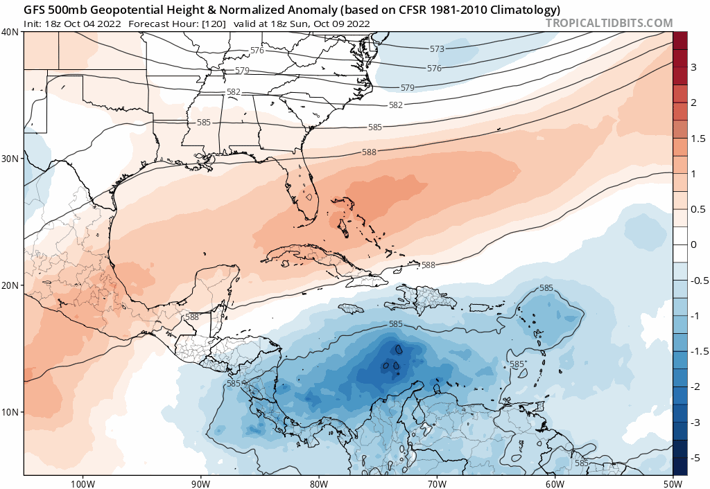
[]https://i.postimg.cc/QNPnfJb8/gfs-z500a-Norm-watl-fh120-222.gif[/img]
I don't know how that trough does not pick that up. It actually buries itself. Maybe I am misreading the 500mb.
0 likes
The following post is NOT an official forecast and should not be used as such. It is just the opinion of the poster and may or may not be backed by sound meteorological data. It is NOT endorsed by any professional institution including storm2k.org For Official Information please refer to the NHC and NWS products.
Re: ATL: INVEST 91L - Models
18z HWRF is very weak through 45 hours and struggles to close off an LLC due to 91L’s proximity to South America, just like what happened with Bonnie. I still think a Bonnie repeat is very possible due to the system’s low latitude.
0 likes
Irene '11 Sandy '12 Hermine '16 5/15/2018 Derecho Fay '20 Isaias '20 Elsa '21 Henri '21 Ida '21
I am only a meteorology enthusiast who knows a decent amount about tropical cyclones. Look to the professional mets, the NHC, or your local weather office for the best information.
I am only a meteorology enthusiast who knows a decent amount about tropical cyclones. Look to the professional mets, the NHC, or your local weather office for the best information.
Re: ATL: INVEST 91L - Models
aspen wrote:18z HWRF is very weak through 45 hours and struggles to close off an LLC due to 91L’s proximity to South America, just like what happened with Bonnie. I still think a Bonnie repeat is very possible due to the system’s low latitude.
91L will be moving much slower than Bonnie, though. Bonnie's forward speed was just as detrimental to development as its proximity to land.
3 likes
TC naming lists: retirements and intensity
Most aggressive Advisory #1's in North Atlantic (cr. kevin for starting the list)
Most aggressive Advisory #1's in North Atlantic (cr. kevin for starting the list)
-
cheezyWXguy
- Category 5
- Posts: 6282
- Joined: Mon Feb 13, 2006 12:29 am
- Location: Dallas, TX
Re: ATL: INVEST 91L - Models
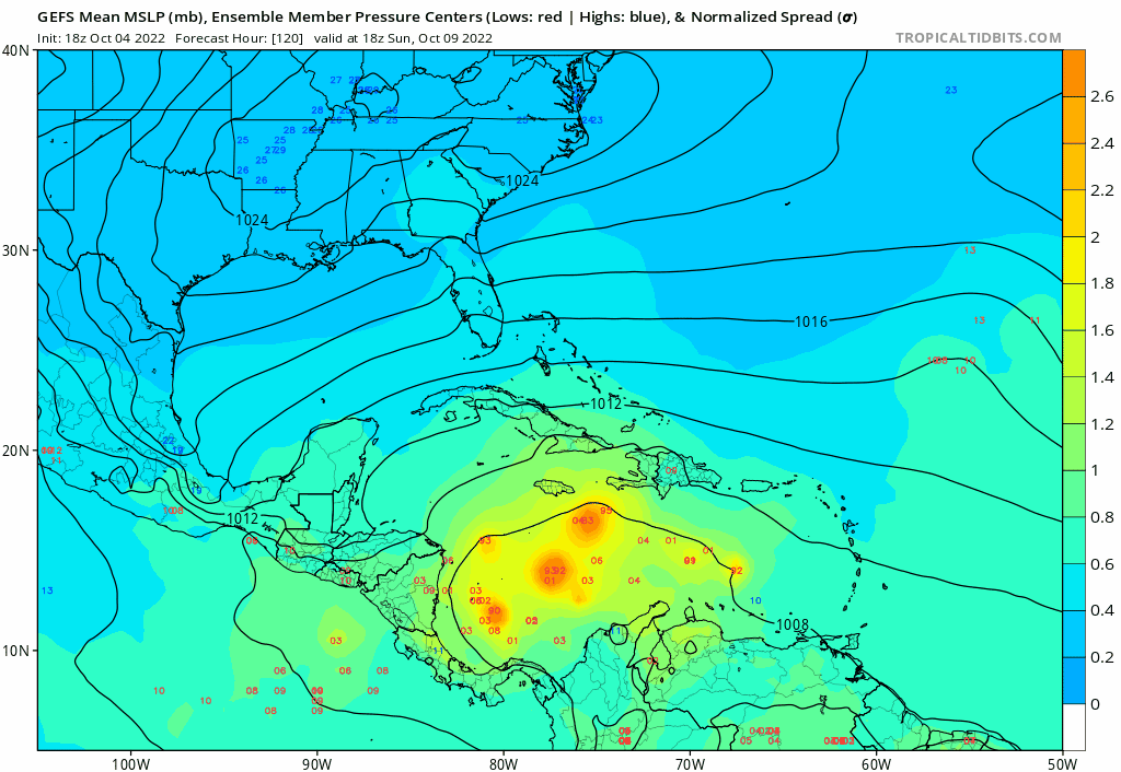
18z GEFS has a lot larger spread in the Caribbean by a week out, and has a stronger signal for a deeper trough. Could be the classic weak ridge/strong trough bias, but if not, it seems that speed and strength by the end of the weekend could have some impact on where this goes. Faster=CA, slower=farther north if this were plausible
1 likes
-
gatorcane
- S2K Supporter
- Posts: 23708
- Age: 48
- Joined: Sun Mar 13, 2005 3:54 pm
- Location: Boca Raton, FL
Re: ATL: INVEST 91L - Models
cheezyWXguy wrote:18z GEFS has a lot larger spread in the Caribbean by a week out, and has a stronger signal for a deeper trough. Could be the classic weak ridge/strong trough bias, but if not, it seems that speed and strength by the end of the weekend could have some impact on where this goes. Faster=CA, slower=farther north if this were plausible
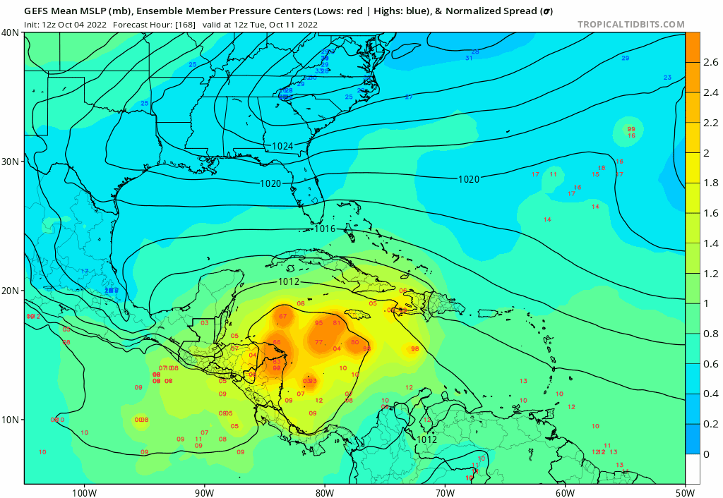
Yes exactly, 18Z GEFS loop, speed makes a big difference where it ends up. Hard to believe we will be talking about 91l 270 hours from now:
0 likes
Re: ATL: INVEST 91L - Models
18z HWRF just copy-pasted Ian's structural evolution from September 25th-26th: loosely associated scattered storms (9/25) followed by a spiral structure with a tiny core (9/26).


1 likes
Irene '11 Sandy '12 Hermine '16 5/15/2018 Derecho Fay '20 Isaias '20 Elsa '21 Henri '21 Ida '21
I am only a meteorology enthusiast who knows a decent amount about tropical cyclones. Look to the professional mets, the NHC, or your local weather office for the best information.
I am only a meteorology enthusiast who knows a decent amount about tropical cyclones. Look to the professional mets, the NHC, or your local weather office for the best information.
-
cheezyWXguy
- Category 5
- Posts: 6282
- Joined: Mon Feb 13, 2006 12:29 am
- Location: Dallas, TX
Re: ATL: INVEST 91L - Models
No talk on the 0z models? Sheesh, this board dies when the threat to the US is low. 0z gefs is much more consolidated than the 18z with most tracks looking like they go into Belize or southern Mexico. Gfs is highly inconsistent on its handling of the trough around 10 days, gefs track is a safe bet
6 likes
Who is online
Users browsing this forum: No registered users and 73 guests