
https://twitter.com/burgwx/status/1577680423727075329
EPAC: JULIA - Models
Moderator: S2k Moderators
Re: ATL: INVEST 91L - Models
4 likes
TC naming lists: retirements and intensity
Most aggressive Advisory #1's in North Atlantic (cr. kevin for starting the list)
Most aggressive Advisory #1's in North Atlantic (cr. kevin for starting the list)

Re: ATL: INVEST 91L - Models
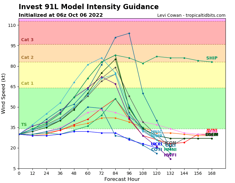
There’s a shockingly high amount of timing variation between models. The GFS/GEFS are really slow and show landfall late Monday, but the ICON is much faster and has a Saturday afternoon landfall. This wide range of landfall times also means there’s a wide range of possibilities for how much time 91L has to organize and intensify, so in theory, anything from a Bonnie repeat to a RI’ing Cat 4 is on the table right now. I still think another Bonnie is the most likely option right now.
1 likes
Irene '11 Sandy '12 Hermine '16 5/15/2018 Derecho Fay '20 Isaias '20 Elsa '21 Henri '21 Ida '21
I am only a meteorology enthusiast who knows a decent amount about tropical cyclones. Look to the professional mets, the NHC, or your local weather office for the best information.
I am only a meteorology enthusiast who knows a decent amount about tropical cyclones. Look to the professional mets, the NHC, or your local weather office for the best information.
Re: ATL: INVEST 91L - Models
6z and 12z GFS both trending south, now sending 91L into Nicaragua in line with other models. Intensity much lower as a result.
1 likes
TC naming lists: retirements and intensity
Most aggressive Advisory #1's in North Atlantic (cr. kevin for starting the list)
Most aggressive Advisory #1's in North Atlantic (cr. kevin for starting the list)
Re: ATL: INVEST 91L - Models
https://twitter.com/AndyHazelton/status/1577723124266799114
12z Euro gets it down to 990 mb before a Nicaragua landfall.
12z Euro gets it down to 990 mb before a Nicaragua landfall.
0 likes
TC naming lists: retirements and intensity
Most aggressive Advisory #1's in North Atlantic (cr. kevin for starting the list)
Most aggressive Advisory #1's in North Atlantic (cr. kevin for starting the list)
-
Category5Kaiju

- Category 5

- Posts: 4347
- Joined: Thu Dec 24, 2020 12:45 pm
- Location: Seattle during the summer, Phoenix during the winter
Re: ATL: INVEST 91L - Models
Teban54 wrote:https://twitter.com/AndyHazelton/status/1577723124266799114?s=20&t=bM6RBe9VYJpCq6k57fv6tg
12z Euro gets it down to 990 mb before a Nicaragua landfall.
Waay too early to know of course, but for some reason I'm getting some Iota vibes from this storm. Maybe it's just the location; really hope it won't be anywhere near as powerful.
0 likes
Unless explicitly stated, all information in my posts is based on my own opinions and observations. Tropical storms and hurricanes can be extremely dangerous. Refer to an accredited weather research agency or meteorologist if you need to make serious decisions regarding an approaching storm.
-
Iceresistance

- Category 5
- Posts: 9608
- Age: 22
- Joined: Sat Oct 10, 2020 9:45 am
- Location: Tecumseh, OK/Norman, OK
Re: ATL: INVEST 91L - Models
May never know on the 12z Canadian, this run is toast.
0 likes
Bill 2015 & Beta 2020
Winter 2020-2021
All observations are in Tecumseh, OK unless otherwise noted.
Winter posts are focused mainly for Oklahoma & Texas.
Take any of my forecasts with a grain of salt, refer to the NWS, SPC, and NHC for official information
Never say Never with weather! Because ANYTHING is possible!
Winter 2020-2021
All observations are in Tecumseh, OK unless otherwise noted.
Winter posts are focused mainly for Oklahoma & Texas.
Take any of my forecasts with a grain of salt, refer to the NWS, SPC, and NHC for official information
Never say Never with weather! Because ANYTHING is possible!
Re: ATL: INVEST 91L - Models
0 likes
TC naming lists: retirements and intensity
Most aggressive Advisory #1's in North Atlantic (cr. kevin for starting the list)
Most aggressive Advisory #1's in North Atlantic (cr. kevin for starting the list)
Re: ATL: INVEST 91L - Models
18z HWRF has trended stronger too, and now has a weak TS within 12-24 hours.
0 likes
Irene '11 Sandy '12 Hermine '16 5/15/2018 Derecho Fay '20 Isaias '20 Elsa '21 Henri '21 Ida '21
I am only a meteorology enthusiast who knows a decent amount about tropical cyclones. Look to the professional mets, the NHC, or your local weather office for the best information.
I am only a meteorology enthusiast who knows a decent amount about tropical cyclones. Look to the professional mets, the NHC, or your local weather office for the best information.

Re: ATL: INVEST 91L - Models
0Z UKMET: TCG hour 120 at 13.0N, 79.6W. Then moves west to just E of Nicaragua at the end of the run at 12.8N, 82.9W.
12Z UKMET: TCG 12 hours earlier. Then moves west into Nicaragua followed by dissipation:
NEW TROPICAL CYCLONE FORECAST TO DEVELOP AFTER 96 HOURS
FORECAST POSITION AT T+ 96 : 13.2N 80.1W
LEAD CENTRAL MAXIMUM WIND
VERIFYING TIME TIME POSITION PRESSURE (MB) SPEED (KNOTS)
-------------- ---- -------- ------------- -------------
1200UTC 09.10.2022 96 13.2N 80.1W 1005 27
0000UTC 10.10.2022 108 12.9N 82.3W 1004 27
1200UTC 10.10.2022 120 12.7N 83.4W 1005 28
0000UTC 11.10.2022 132 CEASED TRACKING
0 likes
Personal Forecast Disclaimer:
The posts in this forum are NOT official forecasts and should not be used as such. They are just the opinion of the poster and may or may not be backed by sound meteorological data. They are NOT endorsed by any professional institution or storm2k.org. For official information, please refer to the NHC and NWS products.
The posts in this forum are NOT official forecasts and should not be used as such. They are just the opinion of the poster and may or may not be backed by sound meteorological data. They are NOT endorsed by any professional institution or storm2k.org. For official information, please refer to the NHC and NWS products.
Re: ATL: INVEST 91L - Models
0 likes
TC naming lists: retirements and intensity
Most aggressive Advisory #1's in North Atlantic (cr. kevin for starting the list)
Most aggressive Advisory #1's in North Atlantic (cr. kevin for starting the list)
Re: ATL: INVEST 91L - Models
The forecast landfall times are slowly getting closer and close together, although there’s still significant spread. On the fast end is the ICON with a landfall as early as 09z Sunday. The GFS and CMC are the slowest, with a landfall as late as 00z Monday. The Euro and HWRF are right down the middle with a landfall between 15z-18z Sunday afternoon.
1 likes
Irene '11 Sandy '12 Hermine '16 5/15/2018 Derecho Fay '20 Isaias '20 Elsa '21 Henri '21 Ida '21
I am only a meteorology enthusiast who knows a decent amount about tropical cyclones. Look to the professional mets, the NHC, or your local weather office for the best information.
I am only a meteorology enthusiast who knows a decent amount about tropical cyclones. Look to the professional mets, the NHC, or your local weather office for the best information.
Re: ATL: INVEST 91L - Models
aspen wrote:The forecast landfall times are slowly getting closer and close together, although there’s still significant spread. On the fast end is the ICON with a landfall as early as 09z Sunday. The GFS and CMC are the slowest, with a landfall as late as 00z Monday. The Euro and HWRF are right down the middle with a landfall between 15z-18z Sunday afternoon.
The 6Z Euro is a little faster than its 0Z run with landfall ~13Z Sunday. The 6Z GFS is also faster than the 0Z run with landfall ~18Z Sunday. Today's 0Z UKMET is about the same as the later 0Z GFS/CMC with a landfall on Nicaragua 0Z Monday, which is ~12 hours earlier than run from 12 hours earlier (it has TCG tomorrow morning, a whopping 48 hours earlier than its 12Z run yesterday):
NEW TROPICAL CYCLONE FORECAST TO DEVELOP AFTER 36 HOURS
FORECAST POSITION AT T+ 36 : 12.7N 70.4W
LEAD CENTRAL MAXIMUM WIND
VERIFYING TIME TIME POSITION PRESSURE (MB) SPEED (KNOTS)
-------------- ---- -------- ------------- -------------
1200UTC 07.10.2022 36 12.7N 70.4W 1008 29
0000UTC 08.10.2022 48 12.8N 72.6W 1006 29
1200UTC 08.10.2022 60 13.5N 75.7W 1005 33
0000UTC 09.10.2022 72 13.8N 78.5W 1003 30
1200UTC 09.10.2022 84 13.3N 81.3W 1002 32
0000UTC 10.10.2022 96 12.8N 83.3W 1001 32
1200UTC 10.10.2022 108 13.0N 85.5W 1003 31
0000UTC 11.10.2022 120 13.4N 88.1W 1005 24
1200UTC 11.10.2022 132 CEASED TRACKING
1 likes
Personal Forecast Disclaimer:
The posts in this forum are NOT official forecasts and should not be used as such. They are just the opinion of the poster and may or may not be backed by sound meteorological data. They are NOT endorsed by any professional institution or storm2k.org. For official information, please refer to the NHC and NWS products.
The posts in this forum are NOT official forecasts and should not be used as such. They are just the opinion of the poster and may or may not be backed by sound meteorological data. They are NOT endorsed by any professional institution or storm2k.org. For official information, please refer to the NHC and NWS products.
Re: ATL: THIRTEEN - Models
12z ICON is a little slower and stronger.
12z GFS finally shows a straightforward track without any interaction with magical Colombian vorticity, and has a midday Sunday landfall.
12z CMC still has a landfall late Sunday afternoon or early Sunday evening.
12z GFS finally shows a straightforward track without any interaction with magical Colombian vorticity, and has a midday Sunday landfall.
12z CMC still has a landfall late Sunday afternoon or early Sunday evening.
0 likes
Irene '11 Sandy '12 Hermine '16 5/15/2018 Derecho Fay '20 Isaias '20 Elsa '21 Henri '21 Ida '21
I am only a meteorology enthusiast who knows a decent amount about tropical cyclones. Look to the professional mets, the NHC, or your local weather office for the best information.
I am only a meteorology enthusiast who knows a decent amount about tropical cyclones. Look to the professional mets, the NHC, or your local weather office for the best information.
Re: ATL: THIRTEEN - Models
12Z UKMET a little stronger and has Nicaragua landfall even earlier by some 8 hours than 0Z run, by ~noon EDT on Sunday, which is ~20 hours earlier than the run from 12Z yesterday!
TROPICAL DEPRESSION 91L ANALYSED POSITION : 11.8N 66.4W
ATCF IDENTIFIER : AL912022
LEAD CENTRAL MAXIMUM WIND
VERIFYING TIME TIME POSITION PRESSURE (MB) SPEED (KNOTS)
-------------- ---- -------- ------------- -------------
1200UTC 06.10.2022 0 11.8N 66.4W 1008 29
0000UTC 07.10.2022 12 11.7N 68.5W 1007 28
1200UTC 07.10.2022 24 12.7N 71.2W 1007 36
0000UTC 08.10.2022 36 13.3N 73.5W 1004 33
1200UTC 08.10.2022 48 13.6N 77.1W 1003 34
0000UTC 09.10.2022 60 13.6N 80.2W 1000 34
1200UTC 09.10.2022 72 13.3N 82.8W 998 37
0000UTC 10.10.2022 84 13.0N 84.7W 1000 31
1200UTC 10.10.2022 96 13.0N 88.6W 1004 27
0000UTC 11.10.2022 108 CEASED TRACKING
0 likes
Personal Forecast Disclaimer:
The posts in this forum are NOT official forecasts and should not be used as such. They are just the opinion of the poster and may or may not be backed by sound meteorological data. They are NOT endorsed by any professional institution or storm2k.org. For official information, please refer to the NHC and NWS products.
The posts in this forum are NOT official forecasts and should not be used as such. They are just the opinion of the poster and may or may not be backed by sound meteorological data. They are NOT endorsed by any professional institution or storm2k.org. For official information, please refer to the NHC and NWS products.
Re: ATL: THIRTEEN - Models
12z HWRF shifts a little north and slower in the SWCar. By Sunday morning, it’s heading to the Nicaragua/Honduras border as a mid-970s system only starting to undergo RI and will make landfall before getting too strong.
0 likes
Irene '11 Sandy '12 Hermine '16 5/15/2018 Derecho Fay '20 Isaias '20 Elsa '21 Henri '21 Ida '21
I am only a meteorology enthusiast who knows a decent amount about tropical cyclones. Look to the professional mets, the NHC, or your local weather office for the best information.
I am only a meteorology enthusiast who knows a decent amount about tropical cyclones. Look to the professional mets, the NHC, or your local weather office for the best information.
-
Tailgater33
- Tropical Depression

- Posts: 94
- Joined: Thu Jun 02, 2022 9:15 am
Re: ATL: THIRTEEN - Models
I for one, am very thankful of the strong 500mb high nosing it’s way westward to keep PT 13 far enuf south to keep it in check for now and hopefully fast enuf to not reach hurricane strength before reaching Central America. We don’t another Monster in the GOM. Flooding will likely be the main issue
1 likes
Re: ATL: THIRTEEN - Models
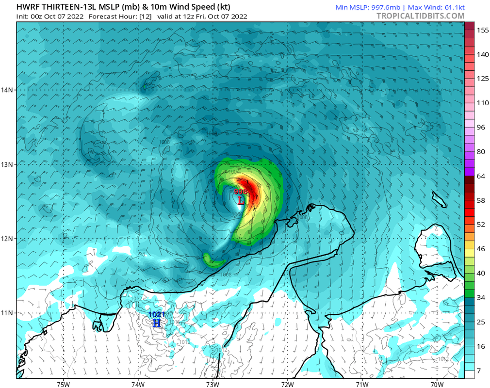
18z HWRF has a super early landfall between 06z-09z Sunday morning. However, this run initialized PTC13 at ~70.6W @00z 10/7, when it instead looks to be around 69.5-70.0W; the actual landfall would probably be another 6hrs or so later than the HWRF is showing.
0 likes
Irene '11 Sandy '12 Hermine '16 5/15/2018 Derecho Fay '20 Isaias '20 Elsa '21 Henri '21 Ida '21
I am only a meteorology enthusiast who knows a decent amount about tropical cyclones. Look to the professional mets, the NHC, or your local weather office for the best information.
I am only a meteorology enthusiast who knows a decent amount about tropical cyclones. Look to the professional mets, the NHC, or your local weather office for the best information.
Re: ATL: THIRTEEN - Models
Talk about being aggressive...
Edit: 942 mb at landfall, much stronger than earlier runs. It's also a good 6-12 hrs faster than global models, which means in reality 13/Julia will get even more time to intensify. Obviously still overaggressive given the initialization.
0z HMON peaks at 964 mb.
Edit: 942 mb at landfall, much stronger than earlier runs. It's also a good 6-12 hrs faster than global models, which means in reality 13/Julia will get even more time to intensify. Obviously still overaggressive given the initialization.
0z HMON peaks at 964 mb.
0 likes
TC naming lists: retirements and intensity
Most aggressive Advisory #1's in North Atlantic (cr. kevin for starting the list)
Most aggressive Advisory #1's in North Atlantic (cr. kevin for starting the list)
Re: ATL: THIRTEEN - Models
0Z UKMET: once again landfalls earlier than prior run, this time by about 4 hours near 8 AM Sunday, which is 24 hours earlier than the run from just 36 hours earlier:
MET OFFICE TROPICAL CYCLONE GUIDANCE FOR NORTH-EAST PACIFIC AND ATLANTIC
GLOBAL MODEL DATA TIME 0000UTC 07.10.2022
TROPICAL DEPRESSION 13L ANALYSED POSITION : 11.8N 68.9W
ATCF IDENTIFIER : AL132022
LEAD CENTRAL MAXIMUM WIND
VERIFYING TIME TIME POSITION PRESSURE (MB) SPEED (KNOTS)
-------------- ---- -------- ------------- -------------
0000UTC 07.10.2022 0 11.8N 68.9W 1006 28
1200UTC 07.10.2022 12 12.6N 71.3W 1006 33
0000UTC 08.10.2022 24 13.4N 74.3W 1004 35
1200UTC 08.10.2022 36 13.8N 78.0W 1003 39
0000UTC 09.10.2022 48 13.7N 80.9W 999 34
1200UTC 09.10.2022 60 13.5N 83.5W 998 37
0000UTC 10.10.2022 72 13.0N 86.7W 1001 26
1200UTC 10.10.2022 84 CEASED TRACKING
Last edited by LarryWx on Fri Oct 07, 2022 8:28 am, edited 1 time in total.
0 likes
Personal Forecast Disclaimer:
The posts in this forum are NOT official forecasts and should not be used as such. They are just the opinion of the poster and may or may not be backed by sound meteorological data. They are NOT endorsed by any professional institution or storm2k.org. For official information, please refer to the NHC and NWS products.
The posts in this forum are NOT official forecasts and should not be used as such. They are just the opinion of the poster and may or may not be backed by sound meteorological data. They are NOT endorsed by any professional institution or storm2k.org. For official information, please refer to the NHC and NWS products.
Re: ATL: THIRTEEN - Models
If the HWRF is right, Julia’s intensification will be capped by it taking forever to get a nice solid eyewall. The 06z HWRF shows so many bands competing to form a single dominant eyewall, and as a result the system doesn’t bomb out that much, with a landfall of “only” 961mb. The HMON also has complicated eyewall dynamics and what looks like an EWRC, possibly similar to Ian before it made landfall in Cuba.
0 likes
Irene '11 Sandy '12 Hermine '16 5/15/2018 Derecho Fay '20 Isaias '20 Elsa '21 Henri '21 Ida '21
I am only a meteorology enthusiast who knows a decent amount about tropical cyclones. Look to the professional mets, the NHC, or your local weather office for the best information.
I am only a meteorology enthusiast who knows a decent amount about tropical cyclones. Look to the professional mets, the NHC, or your local weather office for the best information.
Who is online
Users browsing this forum: No registered users and 72 guests