Im seeing tc genesis signal in the second week of October.
look like the Philippines would be in play again.
2022 WPAC Season
Moderator: S2k Moderators
Forum rules

The posts in this forum are NOT official forecasts and should not be used as such. They are just the opinion of the poster and may or may not be backed by sound meteorological data. They are NOT endorsed by any professional institution or STORM2K. For official information, please refer to products from the National Hurricane Center and National Weather Service.
-
mrbagyo

- Category 5

- Posts: 3997
- Age: 33
- Joined: Thu Apr 12, 2012 9:18 am
- Location: 14.13N 120.98E
- Contact:
Re: 2022 WPAC Season
0 likes
The posts in this forum are NOT official forecast and should not be used as such. They are just the opinion of the poster and may or may not be backed by sound meteorological data. They are NOT endorsed by any professional institution or storm2k.org. For official information, please refer to RSMC, NHC and NWS products.

Re: 2022 WPAC Season
mrbagyo wrote:Im seeing tc genesis signal in the second week of October.
look like the Philippines would be in play again.
ECMWF 00Z has a west tracker after 1st week. Looks like the CFS forecast is coming to fruition

0 likes
ヤンデレ女が寝取られるているのを見たい!!!
ECMWF ensemble NWPAC plots: https://ecmwfensnwpac.imgbb.com/
Multimodel NWPAC plots: https://multimodelnwpac.imgbb.com/
GFS Ensemble NWPAC plots (16 & 35 day forecast): https://gefsnwpac.imgbb.com/
Plots updated automatically
ECMWF ensemble NWPAC plots: https://ecmwfensnwpac.imgbb.com/
Multimodel NWPAC plots: https://multimodelnwpac.imgbb.com/
GFS Ensemble NWPAC plots (16 & 35 day forecast): https://gefsnwpac.imgbb.com/
Plots updated automatically
Re: 2022 WPAC Season
EPS 12Z. If the op/ensembles are right, the seed for the next storm is already there near 150E.


0 likes
ヤンデレ女が寝取られるているのを見たい!!!
ECMWF ensemble NWPAC plots: https://ecmwfensnwpac.imgbb.com/
Multimodel NWPAC plots: https://multimodelnwpac.imgbb.com/
GFS Ensemble NWPAC plots (16 & 35 day forecast): https://gefsnwpac.imgbb.com/
Plots updated automatically
ECMWF ensemble NWPAC plots: https://ecmwfensnwpac.imgbb.com/
Multimodel NWPAC plots: https://multimodelnwpac.imgbb.com/
GFS Ensemble NWPAC plots (16 & 35 day forecast): https://gefsnwpac.imgbb.com/
Plots updated automatically
-
Kingarabian

- S2K Supporter

- Posts: 16377
- Joined: Sat Aug 08, 2009 3:06 am
- Location: Honolulu, Hawaii
Re: 2022 WPAC Season
With the way things are trending and assuming they do not change, I'm expecting either a strong super Typhoon, or multiple minimal major-strength-esque Typhoons to close out the year by November/December. Simply a lot of anomalous rising motion on the way.
0 likes
RIP Kobe Bryant
-
ElectricStorm

- Category 5
- Posts: 5153
- Age: 25
- Joined: Tue Aug 13, 2019 11:23 pm
- Location: Norman, OK
Re: 2022 WPAC Season
The last few GFS runs have been showing the potential for a powerful typhoon forming behind 23W. Assuming 21W doesn't get named, 23W will be Nesat which means yet another H name could become a big one...
0 likes
B.S Meteorology, University of Oklahoma '25
Please refer to the NHC, NWS, or SPC for official information.
Please refer to the NHC, NWS, or SPC for official information.
-
mrbagyo
- Category 5
- Posts: 3997
- Age: 33
- Joined: Thu Apr 12, 2012 9:18 am
- Location: 14.13N 120.98E
- Contact:
Re: 2022 WPAC Season
ElectricStorm wrote:The last few GFS runs have been showing the potential for a powerful typhoon forming behind 23W. Assuming 21W doesn't get named, 23W will be Nesat which means yet another H name could become a big one...
Im more interested with the one that will follow the H system since it will come at a lower latitude. It might be the first low rider of the season.
GFS is starting to trend more west and south on the latest run
CMC and Euro are also hinting at it.
0 likes
The posts in this forum are NOT official forecast and should not be used as such. They are just the opinion of the poster and may or may not be backed by sound meteorological data. They are NOT endorsed by any professional institution or storm2k.org. For official information, please refer to RSMC, NHC and NWS products.
Re: 2022 WPAC Season
mrbagyo wrote:ElectricStorm wrote:The last few GFS runs have been showing the potential for a powerful typhoon forming behind 23W. Assuming 21W doesn't get named, 23W will be Nesat which means yet another H name could become a big one...
Im more interested with the one that will follow the H system since it will come at a lower latitude. It might be the first low rider of the season.
GFS is starting to trend more west and south on the latest run
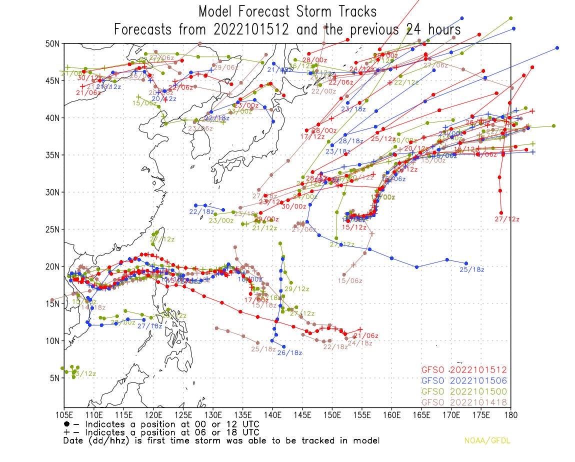
CMC and Euro are also hinting at it. https://s1.gifyu.com/images/track.gfso.2022101512.tc_wpac_ll.4cyc.png
Are these potential issues for the Philippines?
0 likes
-
mrbagyo
- Category 5
- Posts: 3997
- Age: 33
- Joined: Thu Apr 12, 2012 9:18 am
- Location: 14.13N 120.98E
- Contact:
Re: 2022 WPAC Season
underthwx wrote:mrbagyo wrote:ElectricStorm wrote:The last few GFS runs have been showing the potential for a powerful typhoon forming behind 23W. Assuming 21W doesn't get named, 23W will be Nesat which means yet another H name could become a big one...
Im more interested with the one that will follow the H system since it will come at a lower latitude. It might be the first low rider of the season.
GFS is starting to trend more west and south on the latest run
CMC and Euro are also hinting at it. https://s1.gifyu.com/images/track.gfso.2022101512.tc_wpac_ll.4cyc.png
Are these potential issues for the Philippines?
yeah, Late October - November systems frequently deliver nasty impact to the Philippines.
0 likes
The posts in this forum are NOT official forecast and should not be used as such. They are just the opinion of the poster and may or may not be backed by sound meteorological data. They are NOT endorsed by any professional institution or storm2k.org. For official information, please refer to RSMC, NHC and NWS products.
Re: 2022 WPAC Season
mrbagyo wrote:underthwx wrote:mrbagyo wrote:
Im more interested with the one that will follow the H system since it will come at a lower latitude. It might be the first low rider of the season.
GFS is starting to trend more west and south on the latest run
CMC and Euro are also hinting at it. https://s1.gifyu.com/images/track.gfso.2022101512.tc_wpac_ll.4cyc.png
Are these potential issues for the Philippines?
yeah, Late October - November systems frequently deliver nasty impact to the Philippines.
True that, I always worry for my family there, whenever a cyclone threatens the area
0 likes
-
mrbagyo
- Category 5
- Posts: 3997
- Age: 33
- Joined: Thu Apr 12, 2012 9:18 am
- Location: 14.13N 120.98E
- Contact:
Re: 2022 WPAC Season
GFS is shifting back en forth between straight runner (00z and 12z run) and recurve scenario (happy hour runs)
Euro has a low in the same time frame
Canadian has a strengthening TC south of 15N
Euro has a low in the same time frame
Canadian has a strengthening TC south of 15N
0 likes
The posts in this forum are NOT official forecast and should not be used as such. They are just the opinion of the poster and may or may not be backed by sound meteorological data. They are NOT endorsed by any professional institution or storm2k.org. For official information, please refer to RSMC, NHC and NWS products.
-
mrbagyo
- Category 5
- Posts: 3997
- Age: 33
- Joined: Thu Apr 12, 2012 9:18 am
- Location: 14.13N 120.98E
- Contact:
Re: 2022 WPAC Season
GFS now leaning more on a west tracking storm for 3 consecutive runs.
Canadian is also showing a typhoon in the Philippine sea in 10 days.
Euro is not yet enthused with only a weak low as usual
Canadian is also showing a typhoon in the Philippine sea in 10 days.
Euro is not yet enthused with only a weak low as usual
0 likes
The posts in this forum are NOT official forecast and should not be used as such. They are just the opinion of the poster and may or may not be backed by sound meteorological data. They are NOT endorsed by any professional institution or storm2k.org. For official information, please refer to RSMC, NHC and NWS products.
-
doomhaMwx

- Category 5
- Posts: 2494
- Age: 27
- Joined: Tue Apr 18, 2017 4:01 am
- Location: Baguio/Benguet, Philippines
- Contact:
Re: 2022 WPAC Season
Oct-Nov might be shaping up to be a repeat of 2020 when we had a train of TCs consecutively hitting the Philippines and Vietnam at this time of the year.
0 likes
-
mrbagyo
- Category 5
- Posts: 3997
- Age: 33
- Joined: Thu Apr 12, 2012 9:18 am
- Location: 14.13N 120.98E
- Contact:
Re: 2022 WPAC Season
00z back to recurve again lol
0 likes
The posts in this forum are NOT official forecast and should not be used as such. They are just the opinion of the poster and may or may not be backed by sound meteorological data. They are NOT endorsed by any professional institution or storm2k.org. For official information, please refer to RSMC, NHC and NWS products.
-
dexterlabio
- Category 5
- Posts: 3517
- Joined: Sat Oct 24, 2009 11:50 pm
Re: 2022 WPAC Season
mrbagyo wrote:00z back to recurve again lol
The latest ensembles are still split into the westward and recurve groups but it appears there are more west members in the latest run. Euro ensembles are also favoring a more westward scenario, although the operational run still shows nothing.
0 likes
Personal Forecast Disclaimer:
The posts in this forum are NOT official forecast and should not be used as such. They are just the opinion of the poster and may or may not be backed by sound meteorological data. They are NOT endorsed by any professional institution or storm2k.org. For official information, please refer to the NHC and NWS products.
The posts in this forum are NOT official forecast and should not be used as such. They are just the opinion of the poster and may or may not be backed by sound meteorological data. They are NOT endorsed by any professional institution or storm2k.org. For official information, please refer to the NHC and NWS products.
Re: 2022 WPAC Season
Latest Euro showing tropical development over the Philippine Sea next week.

0 likes
ヤンデレ女が寝取られるているのを見たい!!!
ECMWF ensemble NWPAC plots: https://ecmwfensnwpac.imgbb.com/
Multimodel NWPAC plots: https://multimodelnwpac.imgbb.com/
GFS Ensemble NWPAC plots (16 & 35 day forecast): https://gefsnwpac.imgbb.com/
Plots updated automatically
ECMWF ensemble NWPAC plots: https://ecmwfensnwpac.imgbb.com/
Multimodel NWPAC plots: https://multimodelnwpac.imgbb.com/
GFS Ensemble NWPAC plots (16 & 35 day forecast): https://gefsnwpac.imgbb.com/
Plots updated automatically
-
ElectricStorm
- Category 5
- Posts: 5153
- Age: 25
- Joined: Tue Aug 13, 2019 11:23 pm
- Location: Norman, OK
Re: 2022 WPAC Season
0z GFS back to showing a powerful typhoon impacting the Philippines behind 25W/soon-to-be-Nalgae. It's been all over the place though on the last several runs, but it's certainly something to watch. It's definitely primetime for a big one in that area.
0 likes
B.S Meteorology, University of Oklahoma '25
Please refer to the NHC, NWS, or SPC for official information.
Please refer to the NHC, NWS, or SPC for official information.
-
mrbagyo
- Category 5
- Posts: 3997
- Age: 33
- Joined: Thu Apr 12, 2012 9:18 am
- Location: 14.13N 120.98E
- Contact:
Re: 2022 WPAC Season
Just needs to get tagged, it's looking quite healthy already
1 likes
The posts in this forum are NOT official forecast and should not be used as such. They are just the opinion of the poster and may or may not be backed by sound meteorological data. They are NOT endorsed by any professional institution or storm2k.org. For official information, please refer to RSMC, NHC and NWS products.
Re: 2022 WPAC Season
Plots finally updating after ecmwf migrated to a new data center, latest run 12z


It should be an invest soon
It should be an invest soon
0 likes
ヤンデレ女が寝取られるているのを見たい!!!
ECMWF ensemble NWPAC plots: https://ecmwfensnwpac.imgbb.com/
Multimodel NWPAC plots: https://multimodelnwpac.imgbb.com/
GFS Ensemble NWPAC plots (16 & 35 day forecast): https://gefsnwpac.imgbb.com/
Plots updated automatically
ECMWF ensemble NWPAC plots: https://ecmwfensnwpac.imgbb.com/
Multimodel NWPAC plots: https://multimodelnwpac.imgbb.com/
GFS Ensemble NWPAC plots (16 & 35 day forecast): https://gefsnwpac.imgbb.com/
Plots updated automatically
-
mrbagyo
- Category 5
- Posts: 3997
- Age: 33
- Joined: Thu Apr 12, 2012 9:18 am
- Location: 14.13N 120.98E
- Contact:
Re: 2022 WPAC Season
Looks good to go.
0 likes
The posts in this forum are NOT official forecast and should not be used as such. They are just the opinion of the poster and may or may not be backed by sound meteorological data. They are NOT endorsed by any professional institution or storm2k.org. For official information, please refer to RSMC, NHC and NWS products.
-
mrbagyo
- Category 5
- Posts: 3997
- Age: 33
- Joined: Thu Apr 12, 2012 9:18 am
- Location: 14.13N 120.98E
- Contact:
Re: 2022 WPAC Season
The area of convection near Truk atoll might need some monitoring also as it's starting to manifest on most guidance.
It should struggle in the short term due to shear induced by the outflow from 93W
It should struggle in the short term due to shear induced by the outflow from 93W
0 likes
The posts in this forum are NOT official forecast and should not be used as such. They are just the opinion of the poster and may or may not be backed by sound meteorological data. They are NOT endorsed by any professional institution or storm2k.org. For official information, please refer to RSMC, NHC and NWS products.
Who is online
Users browsing this forum: No registered users and 189 guests