EPAC: ROSLYN - Remnants
Moderator: S2k Moderators
-
Sciencerocks
- Category 5

- Posts: 10193
- Age: 40
- Joined: Thu Jul 06, 2017 1:51 am
-
zeehag
- Tropical Storm

- Posts: 181
- Age: 77
- Joined: Sun Jul 17, 2011 9:49 pm
- Location: mazatlan,sinaloa, mexico, fixing patricia's mess.
- Contact:
Re: EPAC: ROSLYN - Hurricane
kevin wrote:All MH Mexico landfalls, 14 since records started.
150 mph
*Patricia (2015)
145 mph
*Madeline (1976)
140 mph
*Twelve (1957)
*Fifteen (1959)
*Kenna (2002)
125 mph
*Olivia (1967)
*Tico (1983)
*Lane (2006)
*Odile (2014)
120 mph
*Roslyn (2022)
115 mph
*Olivia (1975)
*Liza (1976)
*Kiko (1989)
*Willa (2018)
patricia cheated-- double landfall if you will.perula got weaker landfall than colimilla which received eyewall and eye at the marina puerta de navidad..i was there in the eye..was wicked. we had 215 mph winds second half. pumped m y bilges in eye. took 10 min then no more eye...
0 likes
-
cycloneye

- Admin

- Posts: 149728
- Age: 69
- Joined: Thu Oct 10, 2002 10:54 am
- Location: San Juan, Puerto Rico
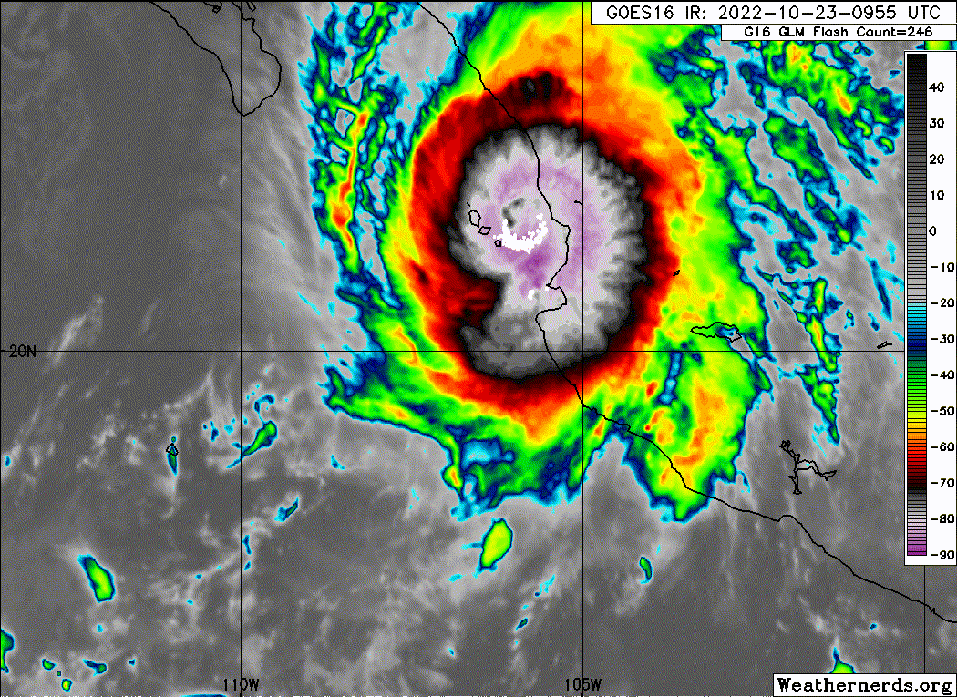
Re: EPAC: ROSLYN - Tropical Storm
BULLETIN
Tropical Storm Roslyn Intermediate Advisory Number 15A
NWS National Hurricane Center Miami FL EP192022
100 PM CDT Sun Oct 23 2022
...HEAVY RAINFALL AND FLASH FLOODING SPREADING INLAND ACROSS
PORTIONS OF WEST-CENTRAL MEXICO...
SUMMARY OF 100 PM CDT...1800 UTC...INFORMATION
----------------------------------------------
LOCATION...23.8N 104.4W
ABOUT 55 MI...90 KM SSE OF THE CITY OF DURANGO MEXICO
MAXIMUM SUSTAINED WINDS...70 MPH...110 KM/H
PRESENT MOVEMENT...NNE OR 30 DEGREES AT 20 MPH...31 KM/H
MINIMUM CENTRAL PRESSURE...988 MB...29.18 INCHES
0 likes
Visit the Caribbean-Central America Weather Thread where you can find at first post web cams,radars
and observations from Caribbean basin members Click Here
and observations from Caribbean basin members Click Here
-
cycloneye
- Admin
- Posts: 149728
- Age: 69
- Joined: Thu Oct 10, 2002 10:54 am
- Location: San Juan, Puerto Rico
Re: EPAC: ROSLYN - Tropical Storm
BULLETIN
Tropical Storm Roslyn Advisory Number 16
NWS National Hurricane Center Miami FL EP192022
400 PM CDT Sun Oct 23 2022
...HEAVY RAINFALL AND RISK OF FLASH FLOODING CONTINUES TO SPREAD
INLAND OVER CENTRAL MEXICO...
SUMMARY OF 400 PM CDT...2100 UTC...INFORMATION
----------------------------------------------
LOCATION...24.6N 103.5W
ABOUT 75 MI...115 KM E OF THE CITY OF DURANGO MEXICO
MAXIMUM SUSTAINED WINDS...45 MPH...75 KM/H
PRESENT MOVEMENT...NE OR 35 DEGREES AT 21 MPH...33 KM/H
MINIMUM CENTRAL PRESSURE...1002 MB...29.59 INCHES
0 likes
Visit the Caribbean-Central America Weather Thread where you can find at first post web cams,radars
and observations from Caribbean basin members Click Here
and observations from Caribbean basin members Click Here
-
Sciencerocks
- Category 5
- Posts: 10193
- Age: 40
- Joined: Thu Jul 06, 2017 1:51 am
-
cycloneye
- Admin
- Posts: 149728
- Age: 69
- Joined: Thu Oct 10, 2002 10:54 am
- Location: San Juan, Puerto Rico
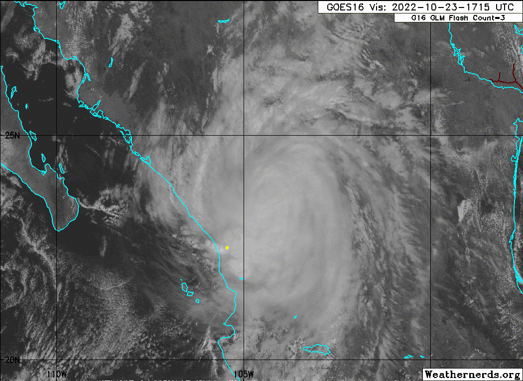
Re: EPAC: ROSLYN - Tropical Storm
Nailed another eye although it was a violent chase but he and his partner are fine.
https://twitter.com/iCyclone/status/1584283515524218880
https://twitter.com/iCyclone/status/1584283835344486400
https://twitter.com/iCyclone/status/1584284246843174912
https://twitter.com/iCyclone/status/1584283515524218880
https://twitter.com/iCyclone/status/1584283835344486400
https://twitter.com/iCyclone/status/1584284246843174912
1 likes
Visit the Caribbean-Central America Weather Thread where you can find at first post web cams,radars
and observations from Caribbean basin members Click Here
and observations from Caribbean basin members Click Here
-
cycloneye
- Admin
- Posts: 149728
- Age: 69
- Joined: Thu Oct 10, 2002 10:54 am
- Location: San Juan, Puerto Rico
Re: EPAC: ROSLYN - Tropical Depression
BULLETIN
Tropical Depression Roslyn Intermediate Advisory Number 16A
NWS National Hurricane Center Miami FL EP192022
700 PM CDT Sun Oct 23 2022
...HEAVY RAINFALL AND RISK OF FLASH FLOODING WITH ROSLYN CONTINUES
TO SPREAD OVER CENTRAL MEXICO...
SUMMARY OF 700 PM CDT...0000 UTC...INFORMATION
----------------------------------------------
LOCATION...25.2N 102.5W
ABOUT 60 MI...95 KM ESE OF THE TORREON MEXICO
MAXIMUM SUSTAINED WINDS...35 MPH...55 KM/H
PRESENT MOVEMENT...NE OR 35 DEGREES AT 21 MPH...33 KM/H
MINIMUM CENTRAL PRESSURE...1005 MB...29.68 INCHES
0 likes
Visit the Caribbean-Central America Weather Thread where you can find at first post web cams,radars
and observations from Caribbean basin members Click Here
and observations from Caribbean basin members Click Here
-
cycloneye
- Admin
- Posts: 149728
- Age: 69
- Joined: Thu Oct 10, 2002 10:54 am
- Location: San Juan, Puerto Rico
Re: EPAC: ROSLYN - Remnants
BULLETIN
Remnants Of Roslyn Advisory Number 17
NWS National Hurricane Center Miami FL EP192022
1000 PM CDT Sun Oct 23 2022
...ROSLYN DISSIPATES OVER EAST-CENTRAL MEXICO...
...THIS IS THE LAST ADVISORY...
SUMMARY OF 1000 PM CDT...0300 UTC...INFORMATION
-----------------------------------------------
LOCATION...26.0N 101.0W
ABOUT 50 MI...80 KM WNW OF MONTERREY MEXICO
MAXIMUM SUSTAINED WINDS...30 MPH...45 KM/H
PRESENT MOVEMENT...NE OR 40 DEGREES AT 22 MPH...35 KM/H
MINIMUM CENTRAL PRESSURE...1005 MB...29.68 INCHES
0 likes
Visit the Caribbean-Central America Weather Thread where you can find at first post web cams,radars
and observations from Caribbean basin members Click Here
and observations from Caribbean basin members Click Here
-
Astromanía
- Category 2

- Posts: 798
- Age: 27
- Joined: Sat Aug 25, 2018 10:34 pm
- Location: Monterrey, N.L, México
Re: EPAC: ROSLYN - Remnants
Today I got Roslyn remants in my city, that's crazy considering it made landfall in the other side of the country, it wasn't bad but make me think about the power of the storm, it remember me the time when also Patricia remants reached my city
0 likes
-
tolakram
- Admin
- Posts: 20186
- Age: 62
- Joined: Sun Aug 27, 2006 8:23 pm
- Location: Florence, KY (name is Mark)
Re: EPAC: ROSLYN - Remnants
2 likes
M a r k
- - - - -
Join us in chat: Storm2K Chatroom Invite. Android and IOS apps also available.
The posts in this forum are NOT official forecasts and should not be used as such. Posts are NOT endorsed by any professional institution or STORM2K.org. For official information and forecasts, please refer to NHC and NWS products.
Who is online
Users browsing this forum: No registered users and 72 guests