Texas Fall 2022
Moderator: S2k Moderators
Forum rules

The posts in this forum are NOT official forecast and should not be used as such. They are just the opinion of the poster and may or may not be backed by sound meteorological data. They are NOT endorsed by any professional institution or STORM2K.


Re: Texas Fall 2022
On board with mid to late November flip. Today's Euro ENS is showing persistent west -NAO. This is fantastic for winter wx in the long run when the Pacific slows it down.
6 likes
The above post and any post by Ntxw is NOT an official forecast and should not be used as such. It is just the opinion of the poster and may or may not be backed by sound meteorological data. It is NOT endorsed by any professional institution including Storm2k. For official information, please refer to NWS products.
Help support Storm2K!
-
Iceresistance

- Category 5

- Posts: 9581
- Age: 22
- Joined: Sat Oct 10, 2020 9:45 am
- Location: Tecumseh, OK/Norman, OK
Re: Texas Fall 2022
Ntxw wrote:On board with mid to late November flip. Today's Euro ENS is showing persistent west -NAO. This is fantastic for winter wx in the long run when the Pacific slows it down.
The CFS model has been showing an active November for quite some time.
0 likes
Bill 2015 & Beta 2020
Winter 2020-2021
All observations are in Tecumseh, OK unless otherwise noted.
Winter posts are focused mainly for Oklahoma & Texas.
Take any of my forecasts with a grain of salt, refer to the NWS, SPC, and NHC for official information
Never say Never with weather! Because ANYTHING is possible!
Winter 2020-2021
All observations are in Tecumseh, OK unless otherwise noted.
Winter posts are focused mainly for Oklahoma & Texas.
Take any of my forecasts with a grain of salt, refer to the NWS, SPC, and NHC for official information
Never say Never with weather! Because ANYTHING is possible!
-
bubba hotep

- S2K Supporter

- Posts: 6014
- Joined: Wed Dec 28, 2016 1:00 am
- Location: Collin County Texas
Re: Texas Fall 2022
Ntxw wrote:On board with mid to late November flip. Today's Euro ENS is showing persistent west -NAO. This is fantastic for winter wx in the long run when the Pacific slows it down.
Weeklies are showing -AO/NAO/EPO combo but also a -WPO. It seems like the last few winters we have had some good setups get undercut by the +WPO. One caveat, the -WPO phase can also mean drier than normal winter time weather across Texas. The forecasted teleconnections point to a cold start to winter but will we be able to breakout of this dry overall pattern to score some winter wx?
2 likes
Winter time post are almost exclusively focused on the DFW area.

Re: Texas Fall 2022
gpsnowman wrote:bubba hotep wrote:Iceresistance wrote:The CFS model is currently suggesting an active November pattern for this area with cold shots.
Euro Weeklies look like about a 20% chance of winter weather in North Texas during the 2nd half of Nov. I can remember one year (forget which one) we had some snow on the ground during Thanksgiving week up here in Collin County.
Late November 2006 had some flurries around Thanksgiving. And when the Jets played the Cowboys one year on Thanksgiving some flurries were present. Not 1993 but maybe 2007 or 08. 93 was the Dolphins. Still bitter about that one.
Thank you, Leon Lett. Geez.
The freezing rain and sleet made it all the way down into the Brazos Valley. It took 7 hours to drive home from College Station after the A&M-Texas game that night. White knuckle driving the entire way.
1 likes
-
bubba hotep
- S2K Supporter
- Posts: 6014
- Joined: Wed Dec 28, 2016 1:00 am
- Location: Collin County Texas
Re: Texas Fall 2022
Here comes our EPAC moisture source

2 likes
Winter time post are almost exclusively focused on the DFW area.
-
Tireman4

- S2K Supporter
- Posts: 5903
- Age: 60
- Joined: Fri Jun 30, 2006 1:08 pm
- Location: Humble, Texas
- Contact:
Re: Texas Fall 2022
DallasAg wrote:gpsnowman wrote:bubba hotep wrote:
Euro Weeklies look like about a 20% chance of winter weather in North Texas during the 2nd half of Nov. I can remember one year (forget which one) we had some snow on the ground during Thanksgiving week up here in Collin County.
Late November 2006 had some flurries around Thanksgiving. And when the Jets played the Cowboys one year on Thanksgiving some flurries were present. Not 1993 but maybe 2007 or 08. 93 was the Dolphins. Still bitter about that one.
Thank you, Leon Lett. Geez.
The freezing rain and sleet made it all the way down into the Brazos Valley. It took 7 hours to drive home from College Station after the A&M-Texas game that night. White knuckle driving the entire way.
Big Cat..lol. Remember that game very well. He is a defensive coach, somewhere in the NFL, maybe Dallas. Will the Cowboys ever get back to the Super Bowl in my lifetime? I hope, but who knows
0 likes
-
Iceresistance
- Category 5
- Posts: 9581
- Age: 22
- Joined: Sat Oct 10, 2020 9:45 am
- Location: Tecumseh, OK/Norman, OK
Re: Texas Fall 2022
It only got down to 67°F, extremely warm for this time of the year.
0 likes
Bill 2015 & Beta 2020
Winter 2020-2021
All observations are in Tecumseh, OK unless otherwise noted.
Winter posts are focused mainly for Oklahoma & Texas.
Take any of my forecasts with a grain of salt, refer to the NWS, SPC, and NHC for official information
Never say Never with weather! Because ANYTHING is possible!
Winter 2020-2021
All observations are in Tecumseh, OK unless otherwise noted.
Winter posts are focused mainly for Oklahoma & Texas.
Take any of my forecasts with a grain of salt, refer to the NWS, SPC, and NHC for official information
Never say Never with weather! Because ANYTHING is possible!
Re: Texas Fall 2022
Really nice to see the 5h pattern setting up. Systems have to dig and cross the southern plains since the path to the east is blocked. If you remember 2020-2021 (minus the big outbreak of cold) there were several chances of snow events prior in December and January due to the same kind of blocking feature.
4 likes
The above post and any post by Ntxw is NOT an official forecast and should not be used as such. It is just the opinion of the poster and may or may not be backed by sound meteorological data. It is NOT endorsed by any professional institution including Storm2k. For official information, please refer to NWS products.
Help support Storm2K!
Help support Storm2K!
-
Iceresistance
- Category 5
- Posts: 9581
- Age: 22
- Joined: Sat Oct 10, 2020 9:45 am
- Location: Tecumseh, OK/Norman, OK
Re: Texas Fall 2022
Ntxw wrote:Really nice to see the 5h pattern setting up. Systems have to dig and cross the southern plains since the path to the east is blocked. If you remember 2020-2021 (minus the big outbreak of cold) there were several chances of snow events prior in December and January due to the same kind of blocking feature.
Yeah, that blocking pattern gave way to the December Snowstorms (including the surprise snowstorm on the 30th) and back-to-back snow in January. I still remember that, even though it's not very well compared to what February did.
0 likes
Bill 2015 & Beta 2020
Winter 2020-2021
All observations are in Tecumseh, OK unless otherwise noted.
Winter posts are focused mainly for Oklahoma & Texas.
Take any of my forecasts with a grain of salt, refer to the NWS, SPC, and NHC for official information
Never say Never with weather! Because ANYTHING is possible!
Winter 2020-2021
All observations are in Tecumseh, OK unless otherwise noted.
Winter posts are focused mainly for Oklahoma & Texas.
Take any of my forecasts with a grain of salt, refer to the NWS, SPC, and NHC for official information
Never say Never with weather! Because ANYTHING is possible!
Re: Texas Fall 2022
You can definitely feel an uptick in humidity today. I hope we get a liquid bludgeoning on Monday.
2 likes
-
bubba hotep
- S2K Supporter
- Posts: 6014
- Joined: Wed Dec 28, 2016 1:00 am
- Location: Collin County Texas
Re: Texas Fall 2022
WPC all in with a pretty nice event. I would like for things to trend westward a bit over the next 48 hrs.
2 likes
Winter time post are almost exclusively focused on the DFW area.
-
Iceresistance
- Category 5
- Posts: 9581
- Age: 22
- Joined: Sat Oct 10, 2020 9:45 am
- Location: Tecumseh, OK/Norman, OK
Re: Texas Fall 2022
I've decided to put out my forecast for Central Oklahoma for the next few days:
Sunday: Strong South winds, Wind Advisory strongly suggested with near record highs in the mid to upper 80s
Sunday Night: Very Warm night with higher humidity, lows in the mid to upper 60s.
Monday: Storms likely after 6 AM, then moving out of the area by Late afternoon, Falling Temperatures throughout the day, the high will only be the low temperature from yesterday, and Afternoon Temperatures in the mid-50s.
Monday Night to Tuesday Morning: Wave #2 of rain arrives the early morning, lows in the mid-40s
Tuesday: Rain Likely until Mid-afternoon with Highs in the upper 50s to near 60
The posts in this forum are NOT official forecasts and should not be used as such. They are just the opinion of the poster and may or may not be backed by sound meteorological data. They are NOT endorsed by any professional institution or STORM2K. For official information, please refer to products from the NHC and NWS.
0 likes
Bill 2015 & Beta 2020
Winter 2020-2021
All observations are in Tecumseh, OK unless otherwise noted.
Winter posts are focused mainly for Oklahoma & Texas.
Take any of my forecasts with a grain of salt, refer to the NWS, SPC, and NHC for official information
Never say Never with weather! Because ANYTHING is possible!
Winter 2020-2021
All observations are in Tecumseh, OK unless otherwise noted.
Winter posts are focused mainly for Oklahoma & Texas.
Take any of my forecasts with a grain of salt, refer to the NWS, SPC, and NHC for official information
Never say Never with weather! Because ANYTHING is possible!
-
Iceresistance
- Category 5
- Posts: 9581
- Age: 22
- Joined: Sat Oct 10, 2020 9:45 am
- Location: Tecumseh, OK/Norman, OK
Re: Texas Fall 2022
Really Windy outside right now, but it's pulling in the moisture from the GoM. Dewpoint is 62°F at my location.
1 likes
Bill 2015 & Beta 2020
Winter 2020-2021
All observations are in Tecumseh, OK unless otherwise noted.
Winter posts are focused mainly for Oklahoma & Texas.
Take any of my forecasts with a grain of salt, refer to the NWS, SPC, and NHC for official information
Never say Never with weather! Because ANYTHING is possible!
Winter 2020-2021
All observations are in Tecumseh, OK unless otherwise noted.
Winter posts are focused mainly for Oklahoma & Texas.
Take any of my forecasts with a grain of salt, refer to the NWS, SPC, and NHC for official information
Never say Never with weather! Because ANYTHING is possible!
Re: Texas Fall 2022
One more unusually warm day and we are about normal to slightly below the rest of October. Halloween looks gorgeous, normal temps and clear.
0 likes
The above post and any post by Ntxw is NOT an official forecast and should not be used as such. It is just the opinion of the poster and may or may not be backed by sound meteorological data. It is NOT endorsed by any professional institution including Storm2k. For official information, please refer to NWS products.
Help support Storm2K!
Help support Storm2K!
-
jasons2k

- Storm2k Executive

- Posts: 8290
- Age: 52
- Joined: Wed Jul 06, 2005 12:32 pm
- Location: The Woodlands, TX
Texas Fall 2022
Update from Jeff Lindner:
A strong storm system, cold front, and remains of hurricane Roslyn will bring a chance of strong to severe thunderstorms to SE TX late Monday into early Tuesday.
Hurricane Roslyn made landfall this morning on the western coast of MX as a powerful category 3 hurricane with winds of 120mph. Earlier this morning a wind gust of 132mph was recorded in the higher terrain along the MX west coast. Roslyn is starting to accelerate northeastward and across the high mountainous terrain over central MX where the low level center of the hurricane will be destroyed. However, mid and upper level moisture is streaming quickly toward SW/S TX along with ripples of energy in the upper level flow. At the same time, a strong short wave trough is digging southward into the SW US and will swing eastward into the southern plains on Monday. Associated with this trough will be a surface cold front which will sweep across TX Monday and Tuesday. Moisture and lift from Roslyn will cross the Rio Grande this evening and shear out across S/SE TX early Monday. When combined with increasing Gulf moisture, expect scattered showers and thunderstorms to begin to develop with heating on Monday across the area, with the greatest chances Monday afternoon.
Arrival of incoming short wave lift and front Monday night will likely result in a broken line of strong thunderstorms. SPC has outlooked all of SE TX in a 2 out of 5 risk for severe weather Monday night/early Tuesday. Mid level flow increase Monday evening over the SE TX warm sector and this will support an increasing damaging wind threat with a line of thunderstorms moving in from the west. Additionally, a weak surface low may form over the mid TX coastal plain late Monday and this will help to back low level winds to the SE which will help to add a slight bit of turning in the low level profile. While damaging winds will be the main threat Monday night, an isolated tornado or two will be possible with any “notches” in the line or if sustained supercell structures develop in the warm sector air mass ahead of the main line.
Overall system is progressive and will clear the area early Tuesday morning with dry northwesterly winds and another cool air mass filtering in along with clearing skies. Fall weather conditions Wednesday and Thursday, but quick changes look likely toward the end of the week as a coastal trough develops along the lower TX coast and moisture quickly spreads back northward. Will bring rain chances back quickly on Friday and may need to linger into Saturday depending on timing of the next front which may bring a decent shot of cold air into the region next weekend.
Jeff Lindner
Director Hydrologic Operations Division/Meteorologist
Harris County Flood Control District
9900 Northwest Freeway | Houston, Texas 77092
346-286-4000 (main) | 346-286-4165 (direct) | 281-924-2091 (cell)
jeff.lindner@hcfcd.org | Twitter: @jefflindner1
0 likes
-
Iceresistance
- Category 5
- Posts: 9581
- Age: 22
- Joined: Sat Oct 10, 2020 9:45 am
- Location: Tecumseh, OK/Norman, OK
Re: Texas Fall 2022
I know it's in the fantasy range, but would that be a nice start to November? 

https://s4.gifyu.com/images/gfs_mslp_pcpn_frzn_scus_fh264-354.gif
Temperatures

https://s1.gifyu.com/images/gfs_T2m_scus_fh264-384.gif
https://s4.gifyu.com/images/gfs_mslp_pcpn_frzn_scus_fh264-354.gif
Temperatures
https://s1.gifyu.com/images/gfs_T2m_scus_fh264-384.gif
0 likes
Bill 2015 & Beta 2020
Winter 2020-2021
All observations are in Tecumseh, OK unless otherwise noted.
Winter posts are focused mainly for Oklahoma & Texas.
Take any of my forecasts with a grain of salt, refer to the NWS, SPC, and NHC for official information
Never say Never with weather! Because ANYTHING is possible!
Winter 2020-2021
All observations are in Tecumseh, OK unless otherwise noted.
Winter posts are focused mainly for Oklahoma & Texas.
Take any of my forecasts with a grain of salt, refer to the NWS, SPC, and NHC for official information
Never say Never with weather! Because ANYTHING is possible!
Re: Texas Fall 2022
Iceresistance wrote:I know it's in the fantasy range, but would that be a nice start to November?
https://s4.gifyu.com/images/gfs_mslp_pcpn_frzn_scus_fh264-354.gif
https://s4.gifyu.com/images/gfs_mslp_pcpn_frzn_scus_fh264-354.gif
Temperatures
https://s1.gifyu.com/images/gfs_T2m_scus_fh264-384.gif
https://s1.gifyu.com/images/gfs_T2m_scus_fh264-384.gif
Euro has a trof coming in for Halloween.
0 likes
The above post and any post by Ntxw is NOT an official forecast and should not be used as such. It is just the opinion of the poster and may or may not be backed by sound meteorological data. It is NOT endorsed by any professional institution including Storm2k. For official information, please refer to NWS products.
Help support Storm2K!
Help support Storm2K!
-
bubba hotep
- S2K Supporter
- Posts: 6014
- Joined: Wed Dec 28, 2016 1:00 am
- Location: Collin County Texas
Re: Texas Fall 2022
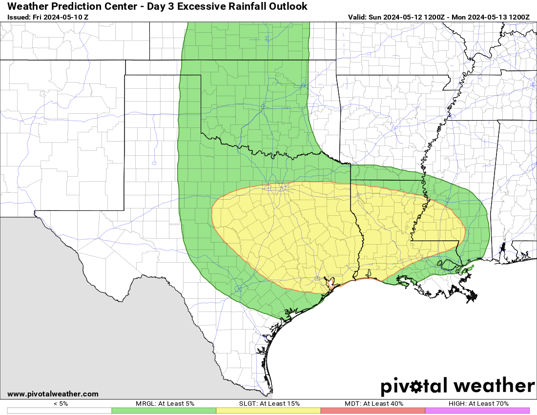
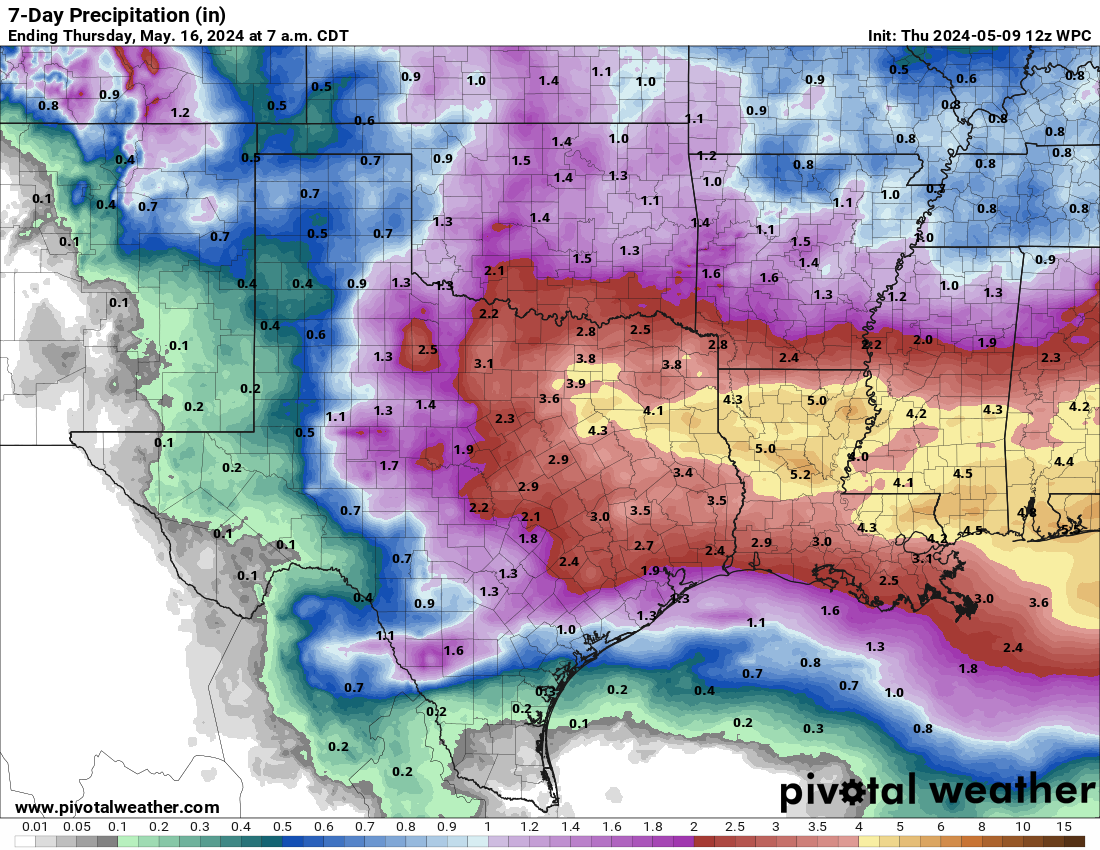
Looks like an active week ahead for Texas with multiple rain chances. This would actually be really good for Oklahoma given that overall they are worse off when it comes to drought.

5 likes
Winter time post are almost exclusively focused on the DFW area.

Re: Texas Fall 2022
bubba hotep wrote:Looks like an active week ahead for Texas with multiple rain chances. This would actually be really good for Oklahoma given that overall they are worse off when it comes to drought.
https://m1o.pivotalweather.com/maps/models/ecmwf_full/2022102312/168/qpf_acc.us_sc.png
Lock it in!! That would be great if we could get that much rain.
2 likes
-
Brent
- S2K Supporter
- Posts: 38740
- Age: 37
- Joined: Sun May 16, 2004 10:30 pm
- Location: Tulsa Oklahoma
- Contact:
Re: Texas Fall 2022
One thing for sure... no more 80s and 90s in sight after this and climo is rapidly turning against it by then. I don't even have a high much above 70 through early November
0 likes
#neversummer
Return to “USA & Caribbean Weather”
Who is online
Users browsing this forum: No registered users and 39 guests