ATL: LISA - Remnants - Discussion
Moderator: S2k Moderators
-
Hypercane_Kyle

- Category 5

- Posts: 3465
- Joined: Sat Mar 07, 2015 7:58 pm
- Location: Cape Canaveral, FL
Re: ATL: INVEST 95L - Discussion
Might get a minimal hurricane out of this if the GFS/Canadian prove accurate.
0 likes
My posts are my own personal opinion, defer to the National Hurricane Center (NHC) and other NOAA products for decision making during hurricane season.
-
Category5Kaiju

- Category 5
- Posts: 4338
- Joined: Thu Dec 24, 2020 12:45 pm
- Location: Seattle during the summer, Phoenix during the winter
Re: ATL: INVEST 95L - Discussion
IcyTundra wrote:This is going to be a really small system which makes it harder to predict intensity.
Ahem, Keith from 2000 anybody?
1 likes
Unless explicitly stated, all information in my posts is based on my own opinions and observations. Tropical storms and hurricanes can be extremely dangerous. Refer to an accredited weather research agency or meteorologist if you need to make serious decisions regarding an approaching storm.
-
Sciencerocks
- Category 5
- Posts: 10186
- Age: 40
- Joined: Thu Jul 06, 2017 1:51 am
Re: ATL: INVEST 95L - Discussion
Category5Kaiju wrote:IcyTundra wrote:This is going to be a really small system which makes it harder to predict intensity.
Ahem, Keith from 2000 anybody?
No. Keith was a slow-moving hurricane. 95L is forecast to move very fast. More like Iris 2001.
0 likes
-
cycloneye

- Admin

- Posts: 149555
- Age: 69
- Joined: Thu Oct 10, 2002 10:54 am
- Location: San Juan, Puerto Rico
Re: ATL: FIFTEEN - Potential Tropical Cyclone - Discussion
NHC will initiate advisories on Potential Tropical Cyclone Fifteen, located over the central Caribbean Sea, at 500 PM AST (2100 UTC)
1 likes
Visit the Caribbean-Central America Weather Thread where you can find at first post web cams,radars
and observations from Caribbean basin members Click Here
and observations from Caribbean basin members Click Here


Re: ATL: INVEST 95L - Discussion
Sciencerocks wrote:https://imagizer.imageshack.com/img922/5784/YqDG79.gif
This shows it to still be tilted due to shear.
0 likes
Personal Forecast Disclaimer:
The posts in this forum are NOT official forecasts and should not be used as such. They are just the opinion of the poster and may or may not be backed by sound meteorological data. They are NOT endorsed by any professional institution or storm2k.org. For official information, please refer to the NHC and NWS products.
The posts in this forum are NOT official forecasts and should not be used as such. They are just the opinion of the poster and may or may not be backed by sound meteorological data. They are NOT endorsed by any professional institution or storm2k.org. For official information, please refer to the NHC and NWS products.

Re: ATL: FIFTEEN - Potential Tropical Cyclone - Discussion
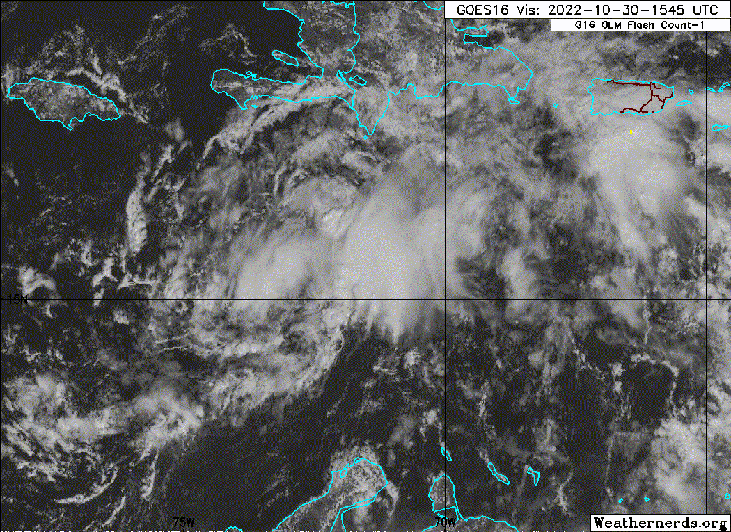
GOES-16 Snow and Ice band shows there is a circulation however the convection is more to the east of it. White is low level clouds grey are higher clouds.
Source - https://col.st/4Yt1i
Source - https://col.st/4Yt1i
0 likes

Re: ATL: FIFTEEN - Potential Tropical Cyclone - Discussion
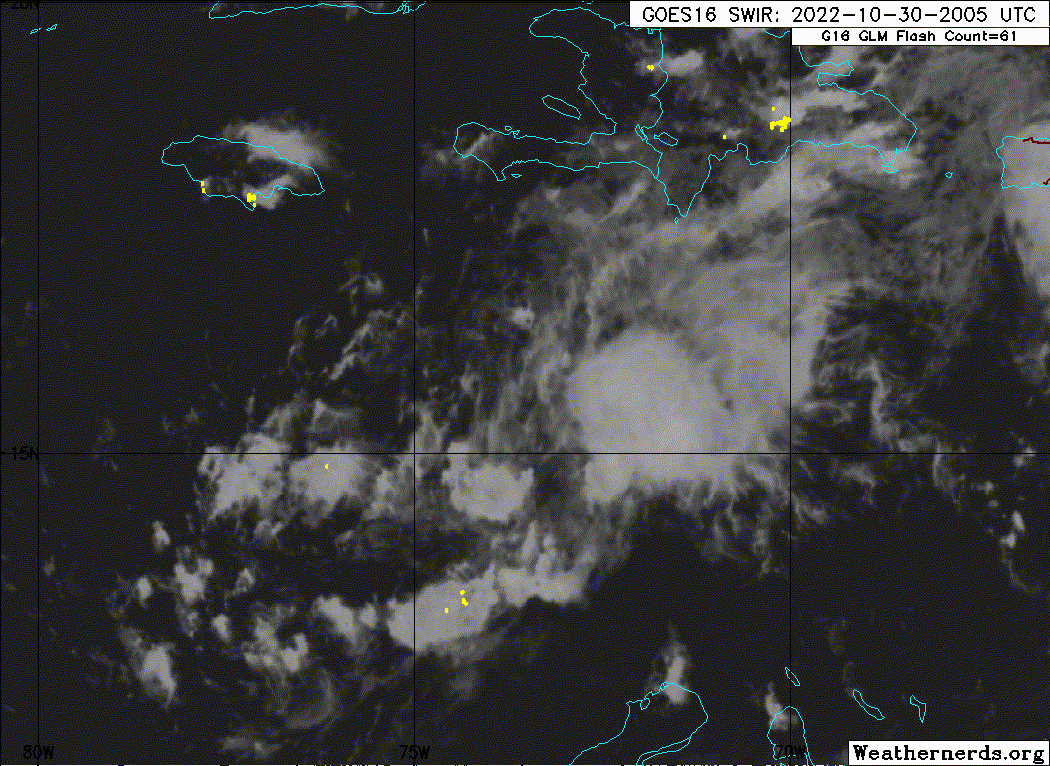
From the 5pm discussion. This might be why the HWRF made 15L into a compact pinhole storm in today’s 12z run.
Mid-level relative humidity is quite low (55-60
percent), but given the relatively low shear, this may act to keep
the system's structure small with a constricted radius of maximum
winds.
0 likes
Irene '11 Sandy '12 Hermine '16 5/15/2018 Derecho Fay '20 Isaias '20 Elsa '21 Henri '21 Ida '21
I am only a meteorology enthusiast who knows a decent amount about tropical cyclones. Look to the professional mets, the NHC, or your local weather office for the best information.
I am only a meteorology enthusiast who knows a decent amount about tropical cyclones. Look to the professional mets, the NHC, or your local weather office for the best information.
-
Sciencerocks
- Category 5
- Posts: 10186
- Age: 40
- Joined: Thu Jul 06, 2017 1:51 am
-
ElectricStorm

- Category 5
- Posts: 5148
- Age: 25
- Joined: Tue Aug 13, 2019 11:23 pm
- Location: Norman, OK
Re: ATL: FIFTEEN - Potential Tropical Cyclone - Discussion
15L FIFTEEN 221031 0000 15.7N 74.4W ATL 35 1005
0 likes
B.S Meteorology, University of Oklahoma '25
Please refer to the NHC, NWS, or SPC for official information.
Please refer to the NHC, NWS, or SPC for official information.

Re: ATL: FIFTEEN - Potential Tropical Cyclone - Discussion
I do understand that PTC 15 is not of significant interest to many at this time, especially based on its projected track and what has happened so far during this bizarre/horrific season. It is against this background that I wish to express my appreciation to those persons/experts who have been posting model runs, graphic, current data and giving their expert opinion on PTC 15.
Much appreciated and wishing for a safe rest of the hurricane season to all S2K moderators, posters, readers and your families.
Much appreciated and wishing for a safe rest of the hurricane season to all S2K moderators, posters, readers and your families.
10 likes


Re: ATL: FIFTEEN - Potential Tropical Cyclone - Discussion
CaribJam wrote:I do understand that PTC 15 is not of significant interest to many at this time, especially based on its projected track and what has happened so far during this bizarre/horrific season. It is against this background that I wish to express my appreciation to those persons/experts who have been posting model runs, graphic, current data and giving their expert opinion on PTC 15.
Much appreciated and wishing for a safe rest of the hurricane season to all S2K moderators, posters, readers and your families.
Please keep posting.
0 likes
FAA ATP
Belize UAS Operator
Belize UAS Operator
-
Sciencerocks
- Category 5
- Posts: 10186
- Age: 40
- Joined: Thu Jul 06, 2017 1:51 am
-
cycloneye
- Admin
- Posts: 149555
- Age: 69
- Joined: Thu Oct 10, 2002 10:54 am
- Location: San Juan, Puerto Rico
Re: ATL: FIFTEEN - Potential Tropical Cyclone - Discussion
TXNT24 KNES 311155
TCSNTL
A. 15L (NONAME)
B. 31/1130Z
C. 15.4N
D. 76.6W
E. THREE/GOES-E
F. T1.0/1.0
G. IR/EIR/SWIR
H. REMARKS...>2/10 BANDING YIELDS A DT=1.0. MET AND PT AGREE. THE FT
IS BASED ON THE DT.
I. ADDL POSITIONS
NIL
...LEE
TCSNTL
A. 15L (NONAME)
B. 31/1130Z
C. 15.4N
D. 76.6W
E. THREE/GOES-E
F. T1.0/1.0
G. IR/EIR/SWIR
H. REMARKS...>2/10 BANDING YIELDS A DT=1.0. MET AND PT AGREE. THE FT
IS BASED ON THE DT.
I. ADDL POSITIONS
NIL
...LEE
0 likes
Visit the Caribbean-Central America Weather Thread where you can find at first post web cams,radars
and observations from Caribbean basin members Click Here
and observations from Caribbean basin members Click Here
-
MarioProtVI
- Category 5
- Posts: 1034
- Age: 24
- Joined: Sun Sep 29, 2019 7:33 pm
- Location: New Jersey
Re: ATL: FIFTEEN - Potential Tropical Cyclone - Discussion
It would not be 2022 without POTC 15 struggling with organized convection despite passing DMAX and taking longer then expected to become a named storm. Guess those low RH values really are hampering this more then NHC thought.
Edit: 12z intensity guidance has considerably dropped this off and now barely makes it a weak-to-moderate storm. Expecting a big drop in intensity forecast at 11, at most peaking at 50 kt.
Edit 2: https://twitter.com/AndyHazelton/status/1587057335456997377
Edit: 12z intensity guidance has considerably dropped this off and now barely makes it a weak-to-moderate storm. Expecting a big drop in intensity forecast at 11, at most peaking at 50 kt.
Edit 2: https://twitter.com/AndyHazelton/status/1587057335456997377
0 likes
Re: ATL: FIFTEEN - Potential Tropical Cyclone - Discussion
NRL
15L LISA 221031 1200 15.5N 76.7W ATL 35 1003
al152022 LISA 20221031 1200 15.5 -76.7 L TS 35 1003
al152022 LISA 20221031 1200 15.5 -76.7 L TS 35 1003
2 likes
Re: ATL: LISA - Tropical Storm - Discussion
Subtrop wrote:NRL15L LISA 221031 1200 15.5N 76.7W ATL 35 1003
al152022 LISA 20221031 1200 15.5 -76.7 L TS 35 1003
AL, 15, 2022103112, , BEST, 0, 155N, 767W, 35, 1003, TS, 34, NEQ, 90, 70, 0, 0, 1009, 160, 70, 0, 0, L, 0, , 0, 0, LISA, M, 0, , 0, 0, 0, 0, genesis-num, 038,
0 likes
-
Sciencerocks
- Category 5
- Posts: 10186
- Age: 40
- Joined: Thu Jul 06, 2017 1:51 am

Re: ATL: FIFTEEN - Potential Tropical Cyclone - Discussion
Sciencerocks wrote:https://imagizer.imageshack.com/img924/2757/LHh4Ij.gif
Still not vertically stacked, but that should change as shear lightens.
0 likes
Personal Forecast Disclaimer:
The posts in this forum are NOT official forecasts and should not be used as such. They are just the opinion of the poster and may or may not be backed by sound meteorological data. They are NOT endorsed by any professional institution or storm2k.org. For official information, please refer to the NHC and NWS products.
The posts in this forum are NOT official forecasts and should not be used as such. They are just the opinion of the poster and may or may not be backed by sound meteorological data. They are NOT endorsed by any professional institution or storm2k.org. For official information, please refer to the NHC and NWS products.
Who is online
Users browsing this forum: No registered users and 8 guests