 yeah this could definitely be big
Texas Fall 2022
Moderator: S2k Moderators
Forum rules

The posts in this forum are NOT official forecast and should not be used as such. They are just the opinion of the poster and may or may not be backed by sound meteorological data. They are NOT endorsed by any professional institution or STORM2K.
-
Brent
- S2K Supporter

- Posts: 38740
- Age: 37
- Joined: Sun May 16, 2004 10:30 pm
- Location: Tulsa Oklahoma
- Contact:
Re: Texas Fall 2022
Tulsa is already forecasting 3-4 inches here and it's 4 days away yeah this could definitely be big
yeah this could definitely be big
0 likes
#neversummer
-
Iceresistance

- Category 5

- Posts: 9581
- Age: 22
- Joined: Sat Oct 10, 2020 9:45 am
- Location: Tecumseh, OK/Norman, OK
Re: Texas Fall 2022
Brent wrote:Tulsa is already forecasting 3-4 inches here and it's 5 days away
So is the WPC for most of Oklahoma!
I've already put out a "Conditional risk of flooding" for all of Oklahoma except the Panhandle and the far SE parts of the state, mainly from the crazy GFS runs. Some GEFS members have over a FOOT in just 2-5 days!
The posts in this forum are NOT official forecasts and should not be used as such. They are just the opinion of the poster and may or may not be backed by sound meteorological data. They are NOT endorsed by any professional institution or STORM2K. For official information, please refer to products from the NHC and NWS.
EDIT: I forgot to put up the disclaimer.
Last edited by Iceresistance on Mon Oct 31, 2022 6:17 am, edited 1 time in total.
0 likes
Bill 2015 & Beta 2020
Winter 2020-2021
All observations are in Tecumseh, OK unless otherwise noted.
Winter posts are focused mainly for Oklahoma & Texas.
Take any of my forecasts with a grain of salt, refer to the NWS, SPC, and NHC for official information
Never say Never with weather! Because ANYTHING is possible!
Winter 2020-2021
All observations are in Tecumseh, OK unless otherwise noted.
Winter posts are focused mainly for Oklahoma & Texas.
Take any of my forecasts with a grain of salt, refer to the NWS, SPC, and NHC for official information
Never say Never with weather! Because ANYTHING is possible!
-
Itryatgolf
- Category 1

- Posts: 305
- Joined: Mon Jul 18, 2022 8:04 pm
- Location: Jackson tn
Re: Texas Fall 2022
12zeuro on today's run has part of the PV entering into the northern Plains day 9-10 
0 likes
-
Iceresistance
- Category 5
- Posts: 9581
- Age: 22
- Joined: Sat Oct 10, 2020 9:45 am
- Location: Tecumseh, OK/Norman, OK
Re: Texas Fall 2022
1 likes
Bill 2015 & Beta 2020
Winter 2020-2021
All observations are in Tecumseh, OK unless otherwise noted.
Winter posts are focused mainly for Oklahoma & Texas.
Take any of my forecasts with a grain of salt, refer to the NWS, SPC, and NHC for official information
Never say Never with weather! Because ANYTHING is possible!
Winter 2020-2021
All observations are in Tecumseh, OK unless otherwise noted.
Winter posts are focused mainly for Oklahoma & Texas.
Take any of my forecasts with a grain of salt, refer to the NWS, SPC, and NHC for official information
Never say Never with weather! Because ANYTHING is possible!
-
bubba hotep

- S2K Supporter
- Posts: 6014
- Joined: Wed Dec 28, 2016 1:00 am
- Location: Collin County Texas
Re: Texas Fall 2022
18z GFS would bring some pretty good drought relief to the Southern Plains


1 likes
Winter time post are almost exclusively focused on the DFW area.
-
Iceresistance
- Category 5
- Posts: 9581
- Age: 22
- Joined: Sat Oct 10, 2020 9:45 am
- Location: Tecumseh, OK/Norman, OK
Re: Texas Fall 2022
bubba hotep wrote:18z GFS would bring some pretty good drought relief to the Southern Plains
I'm more worried about the flooding, I have just warned the High School to this.
0 likes
Bill 2015 & Beta 2020
Winter 2020-2021
All observations are in Tecumseh, OK unless otherwise noted.
Winter posts are focused mainly for Oklahoma & Texas.
Take any of my forecasts with a grain of salt, refer to the NWS, SPC, and NHC for official information
Never say Never with weather! Because ANYTHING is possible!
Winter 2020-2021
All observations are in Tecumseh, OK unless otherwise noted.
Winter posts are focused mainly for Oklahoma & Texas.
Take any of my forecasts with a grain of salt, refer to the NWS, SPC, and NHC for official information
Never say Never with weather! Because ANYTHING is possible!
-
HockeyTx82
- S2K Supporter
- Posts: 2791
- Joined: Tue Oct 27, 2009 11:17 am
- Location: Ponder, TX
Re: Texas Fall 2022
Iceresistance wrote:Brent wrote:Tulsa is already forecasting 3-4 inches here and it's 5 days away
So is the WPC for most of Oklahoma!
I've already put out a "Conditional risk of flooding" for all of Oklahoma except the Panhandle and the far SE parts of the state, mainly from the crazy GFS runs. Some GEFS members have over a FOOT in just 2-5 days!
When you say you put out conditional risk of flooding what do you mean, to who and on what authority?
2 likes
Don't hold me accountable for anything I post on this forum. Leave the real forecasting up to the professionals.
Location: Ponder, TX (all observation posts are this location unless otherwise noted)
Location: Ponder, TX (all observation posts are this location unless otherwise noted)
-
Iceresistance
- Category 5
- Posts: 9581
- Age: 22
- Joined: Sat Oct 10, 2020 9:45 am
- Location: Tecumseh, OK/Norman, OK
Re: Texas Fall 2022
HockeyTx82 wrote:Iceresistance wrote:Brent wrote:Tulsa is already forecasting 3-4 inches here and it's 5 days away
So is the WPC for most of Oklahoma!
I've already put out a "Conditional risk of flooding" for all of Oklahoma except the Panhandle and the far SE parts of the state, mainly from the crazy GFS runs. Some GEFS members have over a FOOT in just 2-5 days!
When you say you put out conditional risk of flooding what do you mean, to who and on what authority?
I forgot to put up the disclaimer.
A conditional flooding risk means that there is a risk for flooding, but the conditions only allow the heavy rainfall if the moisture plumes over the ATL and EPAC collide over us at the perfect timing.
0 likes
Bill 2015 & Beta 2020
Winter 2020-2021
All observations are in Tecumseh, OK unless otherwise noted.
Winter posts are focused mainly for Oklahoma & Texas.
Take any of my forecasts with a grain of salt, refer to the NWS, SPC, and NHC for official information
Never say Never with weather! Because ANYTHING is possible!
Winter 2020-2021
All observations are in Tecumseh, OK unless otherwise noted.
Winter posts are focused mainly for Oklahoma & Texas.
Take any of my forecasts with a grain of salt, refer to the NWS, SPC, and NHC for official information
Never say Never with weather! Because ANYTHING is possible!
-
bubba hotep
- S2K Supporter
- Posts: 6014
- Joined: Wed Dec 28, 2016 1:00 am
- Location: Collin County Texas
-
jasons2k

- Storm2k Executive

- Posts: 8290
- Age: 52
- Joined: Wed Jul 06, 2005 12:32 pm
- Location: The Woodlands, TX
Re: Texas Fall 2022
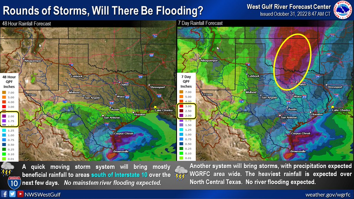
Morning update from Jeff:
Next storm system to impact Texas late tonight into Tuesday.
Upper level trough over the SW US will move eastward today into SW TX and then east across TX on Tuesday. At the surface, a coastal trough will form along the lower TX coast later today into tonight and begin to advect moisture across coastal TX. Position of this trough near and offshore should result in the majority of the rainfall occurring off the coast with showers making it as far inland as I-10. Lift increases through late tonight, and expect showers to develop and spread inland from the coast after midnight and into early Tuesday. Coastal trough will move east on Tuesday well off the upper TX coast and expect widespread showers and thunderstorms over the Gulf waters with scattered showers over SE TX south of I-10.
Rainfall amounts of 1-2 inches will be possible along the coast with amounts generally less than .50 of an inch near I-10 and less than .10 of an inch north of HWY 105.
Upper level system will mostly be east of SE TX on Wednesday and a short wave ridge will build over the southern plains ahead of the next (more potent) storm system due to arrive this weekend. Southerly winds will begin to increase on Thursday as surface low pressure develops in the southern high plains. This will result in a warm and muggy air mass moving northward off the western Gulf of Mexico late this week. Shower and thunderstorm chances will increase Friday into Saturday as a slow moving cold front moves into the region. Current thinking is that the front should reach the coast sometime on Saturday, but models have been trending slower with this system, so showers and storms could linger into Sunday. Factors appear to be in place for some severe weather with this front, but being several days away, lots of finer details to work out between now and then.
Jeff Lindner
Director Hydrologic Operations Division/Meteorologist
Harris County Flood Control District
9900 Northwest Freeway | Houston, Texas 77092
346-286-4000 (main) | 346-286-4165 (direct) | 281-924-2091 (cell)
jeff.lindner@hcfcd.org | Twitter: @jefflindner1
2 likes
-
cheezyWXguy

- Category 5
- Posts: 6282
- Joined: Mon Feb 13, 2006 12:29 am
- Location: Dallas, TX
Re: Texas Fall 2022
DFW NWS has some notable wording in their latest discussion:
The main rain event should occur in the overnight period from Friday evening through daybreak Saturday, as the closed upper low ejects into the Southern High Plains in conjunction with a strong Pacific cold front moving eastward through West Texas. One or more lines of thunderstorms should develop to our west Friday evening and transit our entire forecast area overnight Friday night into Saturday morning. Scattered discrete storms, some potentially strong to severe, may form over North Central Texas after dark, ahead of the main line(s) of storms.
1 likes


Re: Texas Fall 2022
Surprised no one is talking about the huge Alaskan ridge in the medium range. Doesn't mean it gets here but it's not LaLaLand and quite impressive. OPs build some strong HPs in Canada.

Analog package suggests canonical cold surge in North America. Extenuated -ENSO as such in the past, once it turns on, have gone gangbusters 1st half of winter.
Analog package suggests canonical cold surge in North America. Extenuated -ENSO as such in the past, once it turns on, have gone gangbusters 1st half of winter.
3 likes
The above post and any post by Ntxw is NOT an official forecast and should not be used as such. It is just the opinion of the poster and may or may not be backed by sound meteorological data. It is NOT endorsed by any professional institution including Storm2k. For official information, please refer to NWS products.
Help support Storm2K!
Re: Texas Fall 2022
Ntxw wrote:Surprised no one is talking about the huge Alaskan ridge in the medium range. Doesn't mean it gets here but it's not LaLaLand and quite impressive. OPs build some strong HPs in Canada.
https://i.imgur.com/hyPqKhK.png
Analog package suggests canonical cold surge in North America.
I am loving the rain we have gotten and the big storm coming Friday but yeah I am craving some cold weather. Hope it gets here soon. Averages will be in the 60's in a few days.
3 likes
-
cheezyWXguy
- Category 5
- Posts: 6282
- Joined: Mon Feb 13, 2006 12:29 am
- Location: Dallas, TX
Re: Texas Fall 2022
18z gfs looks quite favorable for severe weather Friday night. 500mb pattern shows the cutoff low tilting negative and strengthening as it transits into Texas. The resultant shear profiles, coupled with depicted cape of >1500j/kg looks like an all-hazards event across ntx to me.
1 likes
-
bubba hotep
- S2K Supporter
- Posts: 6014
- Joined: Wed Dec 28, 2016 1:00 am
- Location: Collin County Texas
Re: Texas Fall 2022
Ntxw wrote:Surprised no one is talking about the huge Alaskan ridge in the medium range. Doesn't mean it gets here but it's not LaLaLand and quite impressive. OPs build some strong HPs in Canada.
https://i.imgur.com/hyPqKhK.png
Analog package suggests canonical cold surge in North America. Extenuated -ENSO as such in the past, once it turns on, have gone gangbusters 1st half of winter.
Started to post something yesterday but the +AO/NAO regime doesn't bode well for that cold getting driven down into the Southern Plains. Hopefully, we can hold on to this Pacific pattern and get the North Atlantic pattern to retrograde into a solid -NAO.
0 likes
Winter time post are almost exclusively focused on the DFW area.
-
Iceresistance
- Category 5
- Posts: 9581
- Age: 22
- Joined: Sat Oct 10, 2020 9:45 am
- Location: Tecumseh, OK/Norman, OK
Re: Texas Fall 2022
Ntxw wrote:Surprised no one is talking about the huge Alaskan ridge in the medium range. Doesn't mean it gets here but it's not LaLaLand and quite impressive. OPs build some strong HPs in Canada.
https://i.imgur.com/hyPqKhK.png
Analog package suggests canonical cold surge in North America. Extenuated -ENSO as such in the past, once it turns on, have gone gangbusters 1st half of winter.
The 18z GFS is even crazier! It's also absolutely trying to bring in winter weather to my area, but the dry air wins out.
The crazy cold temperatures are in the fantasy range, but this is a warning sign for things to come later this winter.
0 likes
Bill 2015 & Beta 2020
Winter 2020-2021
All observations are in Tecumseh, OK unless otherwise noted.
Winter posts are focused mainly for Oklahoma & Texas.
Take any of my forecasts with a grain of salt, refer to the NWS, SPC, and NHC for official information
Never say Never with weather! Because ANYTHING is possible!
Winter 2020-2021
All observations are in Tecumseh, OK unless otherwise noted.
Winter posts are focused mainly for Oklahoma & Texas.
Take any of my forecasts with a grain of salt, refer to the NWS, SPC, and NHC for official information
Never say Never with weather! Because ANYTHING is possible!
-
starsfan65

- Category 2

- Posts: 738
- Age: 48
- Joined: Thu Dec 17, 2015 1:18 pm
- Location: Garland,Tx
Re: Texas Fall 2022
Will it be warm for a while?Ntxw wrote:Surprised no one is talking about the huge Alaskan ridge in the medium range. Doesn't mean it gets here but it's not LaLaLand and quite impressive. OPs build some strong HPs in Canada.
https://i.imgur.com/hyPqKhK.png
Analog package suggests canonical cold surge in North America. Extenuated -ENSO as such in the past, once it turns on, have gone gangbusters 1st half of winter.
0 likes
-
Iceresistance
- Category 5
- Posts: 9581
- Age: 22
- Joined: Sat Oct 10, 2020 9:45 am
- Location: Tecumseh, OK/Norman, OK
Re: Texas Fall 2022
18z GEFS has an incredibly strong signal for a cold blast here for being 2 weeks out! 
0 likes
Bill 2015 & Beta 2020
Winter 2020-2021
All observations are in Tecumseh, OK unless otherwise noted.
Winter posts are focused mainly for Oklahoma & Texas.
Take any of my forecasts with a grain of salt, refer to the NWS, SPC, and NHC for official information
Never say Never with weather! Because ANYTHING is possible!
Winter 2020-2021
All observations are in Tecumseh, OK unless otherwise noted.
Winter posts are focused mainly for Oklahoma & Texas.
Take any of my forecasts with a grain of salt, refer to the NWS, SPC, and NHC for official information
Never say Never with weather! Because ANYTHING is possible!
-
cheezyWXguy
- Category 5
- Posts: 6282
- Joined: Mon Feb 13, 2006 12:29 am
- Location: Dallas, TX
Re: Texas Fall 2022
cheezyWXguy wrote:18z gfs looks quite favorable for severe weather Friday night. 500mb pattern shows the cutoff low tilting negative and strengthening as it transits into Texas. The resultant shear profiles, coupled with depicted cape of >1500j/kg looks like an all-hazards event across ntx to me.
The map below is based on the 18z gfs. Wonder if future runs will continue to show such a strong signal

Edit, actually think it’s the 12z. Regardless, pretty colors, high chances, etc etc. Take with as few grains of salt as you would any individual gfs run
1 likes


Return to “USA & Caribbean Weather”
Who is online
Users browsing this forum: AnnularCane, Cpv17 and 82 guests