ATL: LISA - Remnants - Discussion
Moderator: S2k Moderators
-
MGC

- S2K Supporter

- Posts: 5940
- Joined: Sun Mar 23, 2003 9:05 pm
- Location: Pass Christian MS, or what is left.
Re: ATL: LISA - Tropical Storm - Discussion
Lisa looks way more tropical stormish than compared to yesterday. Having my doubts it reaches hurricane intensity......MGC
0 likes
Re: ATL: LISA - Tropical Storm - Discussion
Winds is increasing while the pressure is rising. Very interesting system.
0 likes

Re: ATL: LISA - Tropical Storm - Discussion
Lisa still has pretty weak winds in the southern half of its circulation, which will limit intensification in the short term. I’m concerned about a sudden ramp-up in the last 12-24 hours before landfall once the system’s internal structure becomes better, like what happened with Julia.
0 likes
Irene '11 Sandy '12 Hermine '16 5/15/2018 Derecho Fay '20 Isaias '20 Elsa '21 Henri '21 Ida '21
I am only a meteorology enthusiast who knows a decent amount about tropical cyclones. Look to the professional mets, the NHC, or your local weather office for the best information.
I am only a meteorology enthusiast who knows a decent amount about tropical cyclones. Look to the professional mets, the NHC, or your local weather office for the best information.
-
Hurricane Mike
- Category 2

- Posts: 675
- Joined: Tue Apr 10, 2018 7:44 am
-
Hypercane_Kyle

- Category 5

- Posts: 3465
- Joined: Sat Mar 07, 2015 7:58 pm
- Location: Cape Canaveral, FL
Re: ATL: LISA - Tropical Storm - Discussion
MGC wrote:Lisa looks way more tropical stormish than compared to yesterday. Having my doubts it reaches hurricane intensity......MGC
Funny you mentioned that, because the NHC actually became significantly more aggressive with their intensity forecast @ 11am. Nearly a Cat 2 peak.
0 likes
My posts are my own personal opinion, defer to the National Hurricane Center (NHC) and other NOAA products for decision making during hurricane season.
-
wxman57

- Moderator-Pro Met

- Posts: 23175
- Age: 68
- Joined: Sat Jun 21, 2003 8:06 pm
- Location: Houston, TX (southwest)
Re: ATL: LISA - Tropical Storm - Discussion
I think 45 kts is a more reasonable estimate for the NE-E sector. Elsewhere, winds are below TS strength. Dropsondes and SFMR don't measure sustained 1-min average winds, they're instantaneous winds. I have my doubts that Lisa will become a hurricane prior to landfall, but little doubt that it will be classified as a hurricane prior to landfall. NHC needs to make sure that the general public pay attention to the storm, so they tend to lean toward the high side for intensity estimates. Better for the public to be over prepared vs. under prepared. We have no such concerns when we issue our advisories, as they're not seen by the public. I'd go with 45 kts NE, 30 kts SE, 25 kts SW, and 30 kts in the NW quadrant. Note that the pressure was up to 1006mb on the last recon pass.
0 likes
-
StormSkeptic
- Tropical Low

- Posts: 35
- Joined: Tue Sep 30, 2003 8:40 pm
- Location: New Jersey
Re: ATL: LISA - Tropical Storm - Discussion
To me, the most interesting item from the latest vortex message is the 5° difference in temperature in the core and the tightening of the wind field.
P. Maximum Flight Level Temp & Pressure Altitude Outside Eye: 16°C (61°F) at a pressure alt. of 1,526m (5,007ft)
Q. Maximum Flight Level Temp & Pressure Altitude Inside Eye: 21°C (70°F) at a pressure alt. of 1,526m (5,007ft)
This indicates the core is warming and will likely lead to the pressure continuing to drop and strengthening.
4 likes

Re: ATL: LISA - Tropical Storm - Discussion
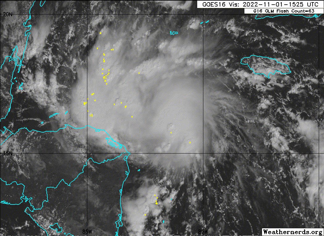
Looks like a feeder band is forming just east of 82W.
Likely will see strengthening to landfall.
Likely will see strengthening to landfall.
0 likes
-
cycloneye

- Admin

- Posts: 149550
- Age: 69
- Joined: Thu Oct 10, 2002 10:54 am
- Location: San Juan, Puerto Rico
Re: ATL: LISA - Tropical Storm - Discussion
AF plane on route to see if Lisa is stronger than 60 mph.
0 likes
Visit the Caribbean-Central America Weather Thread where you can find at first post web cams,radars
and observations from Caribbean basin members Click Here
and observations from Caribbean basin members Click Here

Re: ATL: LISA - Tropical Storm - Discussion
wxman57 wrote:I think 45 kts is a more reasonable estimate for the NE-E sector. Elsewhere, winds are below TS strength. Dropsondes and SFMR don't measure sustained 1-min average winds, they're instantaneous winds. I have my doubts that Lisa will become a hurricane prior to landfall, but little doubt that it will be classified as a hurricane prior to landfall. NHC needs to make sure that the general public pay attention to the storm, so they tend to lean toward the high side for intensity estimates. Better for the public to be over prepared vs. under prepared. We have no such concerns when we issue our advisories, as they're not seen by the public. I'd go with 45 kts NE, 30 kts SE, 25 kts SW, and 30 kts in the NW quadrant. Note that the pressure was up to 1006mb on the last recon pass.
The NHC literally always uses the shorter time-scale wind measurements as analogues for max 1-minute winds with undersampling as a justification... I am surprised to hear a professional met say something like this.
5 likes
-
Sciencerocks
- Category 5
- Posts: 10186
- Age: 40
- Joined: Thu Jul 06, 2017 1:51 am
Re: ATL: LISA - Tropical Storm - Discussion
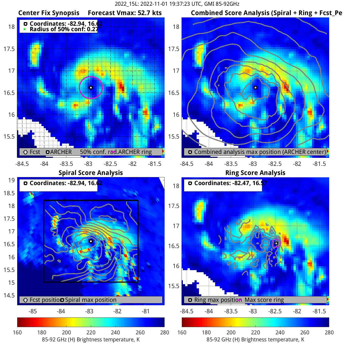
Microwave eye per the GPM. Could easily be a hurricane at 8pm.
1 likes
-
wxman57
- Moderator-Pro Met
- Posts: 23175
- Age: 68
- Joined: Sat Jun 21, 2003 8:06 pm
- Location: Houston, TX (southwest)
Re: ATL: LISA - Tropical Storm - Discussion
It definitely looks more like a real TS this afternoon. Recon is on the way. Perhaps they'll find a pressure around 997mb or so and slowly falling. I have max winds at 70 kts for landfall tomorrow evening in Belize. Small storms can strengthen and weaken very quickly.
2 likes
-
wxman57
- Moderator-Pro Met
- Posts: 23175
- Age: 68
- Joined: Sat Jun 21, 2003 8:06 pm
- Location: Houston, TX (southwest)
Re: ATL: LISA - Tropical Storm - Discussion
kronotsky wrote:wxman57 wrote:I think 45 kts is a more reasonable estimate for the NE-E sector. Elsewhere, winds are below TS strength. Dropsondes and SFMR don't measure sustained 1-min average winds, they're instantaneous winds. I have my doubts that Lisa will become a hurricane prior to landfall, but little doubt that it will be classified as a hurricane prior to landfall. NHC needs to make sure that the general public pay attention to the storm, so they tend to lean toward the high side for intensity estimates. Better for the public to be over prepared vs. under prepared. We have no such concerns when we issue our advisories, as they're not seen by the public. I'd go with 45 kts NE, 30 kts SE, 25 kts SW, and 30 kts in the NW quadrant. Note that the pressure was up to 1006mb on the last recon pass.
The NHC literally always uses the shorter time-scale wind measurements as analogues for max 1-minute winds with undersampling as a justification... I am surprised to hear a professional met say something like this.
I don't agree with over-warning the public by stating a hurricane may have a small area of strong winds that will never be felt at the coast just to try and keep people safe, or not downgrading a hurricane prior to landfall so that people remain alert. Sometimes it works, but it generates public complacency when observed winds are generally 1-2 categories below the stated landfall intensity. I know that surface terrain impacts the wind field, but the public may think they went through a hurricane at a particular strength and came out okay, only to pay less attention to the next hurricane that may really produce the stronger wind. I think that the public would be better served if a more likely wind speed was used for the intensity rather than the max possible wind speed. Perhaps it would be good to go with a 10-min average, but that's very hard to measure by recon, since they can't even measure 1-min winds.
4 likes

Re: ATL: LISA - Tropical Storm - Discussion
wxman57 wrote:kronotsky wrote:wxman57 wrote:I think 45 kts is a more reasonable estimate for the NE-E sector. Elsewhere, winds are below TS strength. Dropsondes and SFMR don't measure sustained 1-min average winds, they're instantaneous winds. I have my doubts that Lisa will become a hurricane prior to landfall, but little doubt that it will be classified as a hurricane prior to landfall. NHC needs to make sure that the general public pay attention to the storm, so they tend to lean toward the high side for intensity estimates. Better for the public to be over prepared vs. under prepared. We have no such concerns when we issue our advisories, as they're not seen by the public. I'd go with 45 kts NE, 30 kts SE, 25 kts SW, and 30 kts in the NW quadrant. Note that the pressure was up to 1006mb on the last recon pass.
The NHC literally always uses the shorter time-scale wind measurements as analogues for max 1-minute winds with undersampling as a justification... I am surprised to hear a professional met say something like this.
I don't agree with over-warning the public by stating a hurricane may have a small area of strong winds that will never be felt at the coast just to try and keep people safe, or not downgrading a hurricane prior to landfall so that people remain alert. Sometimes it works, but it generates public complacency when observed winds are generally 1-2 categories below the stated landfall intensity. I know that surface terrain impacts the wind field, but the public may think they went through a hurricane at a particular strength and came out okay, only to pay less attention to the next hurricane that may really produce the stronger wind. I think that the public would be better served if a more likely wind speed was used for the intensity rather than the max possible wind speed. Perhaps it would be good to go with a 10-min average, but that's very hard to measure by recon, since they can't even measure 1-min winds.
I've often thought this. Just be realistic so when the real mega-buck systems come in, people will actually listen and get the heck out of Dodge.
0 likes
Re: ATL: LISA - Tropical Storm - Discussion
ADT puts it borderline Cat 1.
Looks good on VIS.
See what recon finds.
Looks good on VIS.
See what recon finds.
0 likes
Re: ATL: LISA - Tropical Storm - Discussion
wxman57 wrote:kronotsky wrote:wxman57 wrote:I think 45 kts is a more reasonable estimate for the NE-E sector. Elsewhere, winds are below TS strength. Dropsondes and SFMR don't measure sustained 1-min average winds, they're instantaneous winds. I have my doubts that Lisa will become a hurricane prior to landfall, but little doubt that it will be classified as a hurricane prior to landfall. NHC needs to make sure that the general public pay attention to the storm, so they tend to lean toward the high side for intensity estimates. Better for the public to be over prepared vs. under prepared. We have no such concerns when we issue our advisories, as they're not seen by the public. I'd go with 45 kts NE, 30 kts SE, 25 kts SW, and 30 kts in the NW quadrant. Note that the pressure was up to 1006mb on the last recon pass.
The NHC literally always uses the shorter time-scale wind measurements as analogues for max 1-minute winds with undersampling as a justification... I am surprised to hear a professional met say something like this.
I don't agree with over-warning the public by stating a hurricane may have a small area of strong winds that will never be felt at the coast just to try and keep people safe, or not downgrading a hurricane prior to landfall so that people remain alert. Sometimes it works, but it generates public complacency when observed winds are generally 1-2 categories below the stated landfall intensity. I know that surface terrain impacts the wind field, but the public may think they went through a hurricane at a particular strength and came out okay, only to pay less attention to the next hurricane that may really produce the stronger wind. I think that the public would be better served if a more likely wind speed was used for the intensity rather than the max possible wind speed. Perhaps it would be good to go with a 10-min average, but that's very hard to measure by recon, since they can't even measure 1-min winds.
Sure, that's a coherent position, but given that the entire intensity system has been oriented around this type of measurement for decades now, the NHC would need to look elsewhere if it wanted to turn down its doom-and-gloom dial. This is getting off topic, though; back to Lisa.
1 likes
Re: ATL: LISA - Tropical Storm - Discussion
Sciencerocks wrote:https://imagizer.imageshack.com/img923/6438/fLkO4K.gif
Lisa’s starting to get That Look. The center has really tightened up in the last few hours, outflow is expanding in nearly every direction, and there’ll soon be a burst from the diurnal cycle. Lisa still has roughly 24-30 hours left over water, so if this keeps up then a Cat 2 at landfall is a possibility.
0 likes
Irene '11 Sandy '12 Hermine '16 5/15/2018 Derecho Fay '20 Isaias '20 Elsa '21 Henri '21 Ida '21
I am only a meteorology enthusiast who knows a decent amount about tropical cyclones. Look to the professional mets, the NHC, or your local weather office for the best information.
I am only a meteorology enthusiast who knows a decent amount about tropical cyclones. Look to the professional mets, the NHC, or your local weather office for the best information.
-
wxman57
- Moderator-Pro Met
- Posts: 23175
- Age: 68
- Joined: Sat Jun 21, 2003 8:06 pm
- Location: Houston, TX (southwest)
Re: ATL: LISA - Tropical Storm - Discussion
I see that the NHC is following the TVCN precisely, as TVCN takes it into the southern BoC, moves it slowly north for a bit then back inland into the southern coast. Only problem is that it may not have a circulation then. I think it will weaken to a remnant low more quickly than NHC is forecasting. Either way, no big deal for the BoC. Tremendous wind shear down there and across the Gulf. Cold fronts will be more of a concern this time of year.
1 likes
Who is online
Users browsing this forum: No registered users and 14 guests