
Large but symmetrical 925mb vort
https://tropic.ssec.wisc.edu/real-time/ ... oom=&time=
Possible Development Near the GA/Bahamas (Is Invest 98L)
Moderator: S2k Moderators
Forum rules

The posts in this forum are NOT official forecasts and should not be used as such. They are just the opinion of the poster and may or may not be backed by sound meteorological data. They are NOT endorsed by any professional institution or STORM2K. For official information, please refer to products from the National Hurricane Center and National Weather Service.
Re: Possible Development Near the GA/Bahamas Early Next Week (10/60)
Appears that a significant tornado outbreak could result along the SC coast next Saturday from this.
Also, south FL looks to be at risk as well.
Also, south FL looks to be at risk as well.
0 likes
Re: Possible Development Near the GA/Bahamas Early Next Week (10/60)
GFS is forecasting the LL, ML, and UL vorts stacking in about 48 hrs at about 23.5N 71W
0 likes
Re: Possible Development Near the GA/Bahamas Early Next Week (10/60)
A decent ARWB will develop and anchor in from the east GoM into the Bahamas starting Wednesday.
This would likely allow strengthening of the LL vort and could transition this to a warm core if it isn't already one by then.
This would likely allow strengthening of the LL vort and could transition this to a warm core if it isn't already one by then.
0 likes
Re: Possible Development Near the GA/Bahamas Early Next Week (10/60)
Pressure dropping, winds picking up at the east Carib buoy
https://www.ndbc.noaa.gov/show_plot.php ... _label=AST
https://www.ndbc.noaa.gov/show_plot.php ... _label=AST
0 likes
Re: Possible Development Near the GA/Bahamas Early Next Week (10/60)
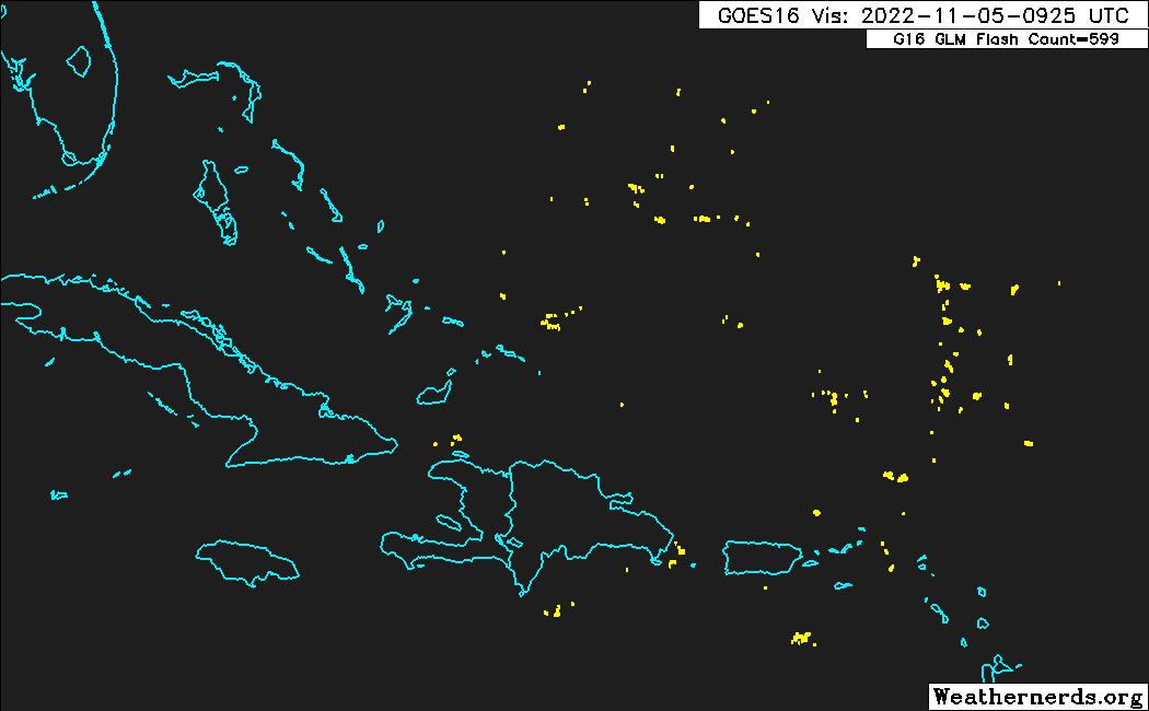
Extreme lightning density with the convection
0 likes

Re: Possible Development Near the GA/Bahamas Early Next Week (10/60)
GCANE wrote:A decent ARWB will develop and anchor in from the east GoM into the Bahamas starting Wednesday.
This would likely allow strengthening of the LL vort and could transition this to a warm core if it isn't already one by then.
Reminds me a little of where Andrew developed not far off the eastern coast of South Florida. A massive solid in place high pressure ridge drove Andrew right into Homestead. You would hope in November we would see a trough that would kick it north by landfall.
1 likes
Re: Possible Development Near the GA/Bahamas Early Next Week (10/60)
The UL trough, north of Hispaniola, is filled with ML moisture and moderate convection.
This should allow for the LL vort to move into the area without convection inhibition.
This should allow for the LL vort to move into the area without convection inhibition.
0 likes
Re: Possible Development Near the GA/Bahamas Early Next Week (10/60)
cane5 wrote:GCANE wrote:A decent ARWB will develop and anchor in from the east GoM into the Bahamas starting Wednesday.
This would likely allow strengthening of the LL vort and could transition this to a warm core if it isn't already one by then.
Reminds me a little of where Andrew developed not far off the eastern coast of South Florida. A massive solid in place high pressure ridge drove Andrew right into Homestead. You would hope in November we would see a trough that would kick it north by landfall.
Looks like it will be pulling significant moisture out of the MDR ITCZ and EPAC by the time it is in the mid Bahamas
0 likes
-
cycloneye

- Admin

- Posts: 149565
- Age: 69
- Joined: Thu Oct 10, 2002 10:54 am
- Location: San Juan, Puerto Rico
Re: Possible Development Near the GA/Bahamas Early Next Week (10/60)
Atlantic Gale Warning:
A large non-tropical low pressure system is expected to develop
across the northeastern Caribbean Sea and southwestern Atlantic by
the latter part of the weekend. The system is initially expected
to be very broad and disorganized. However, it could begin to
acquire subtropical or tropical characteristics during the early
part of next week, and a subtropical or tropical depression could
form during the early to middle portion of next week while the
system moves generally westward to west-northwestward over the
southwestern Atlantic. Regardless of development, there is an
increasing risk of coastal flooding, gale-force winds, heavy
rainfall, rough surf, and beach erosion along much of the
southeastern United States coast, the Florida east coast, and
portions of the central and northwestern Bahamas during the early
to middle part of next week. A tight pressure gradient between the
low and strong high pressure farther north is expected to lead to
a broad area of strong to near-gale force SE winds east of the
low, possibly reaching minimal gale force with very rough seas
north of the Leeward Islands and east of the central Bahamas late
Sun and Sun night. Looking ahead, strong to gale force winds and
rough seas are possible off northeast Florida from late Mon
through mid week as the low pressure shifts northwestward into a
strong ridge centered north of the area. Localized heavy
rainfall is also possible across Puerto Rico and US Virgin Islands
during the next few days. This system also has a low chance of
development over the next 48 hours and a medium chance of
development in the next 5 days. Please refer to the High Seas
Forecast issued by NHC at www.nhc.noaa.gov/text/MIAHSFAT2.shtml
and the Tropical Weather Outlook at www.hurricanes.gov for more
information.
0 likes
Visit the Caribbean-Central America Weather Thread where you can find at first post web cams,radars
and observations from Caribbean basin members Click Here
and observations from Caribbean basin members Click Here
-
cycloneye
- Admin
- Posts: 149565
- Age: 69
- Joined: Thu Oct 10, 2002 10:54 am
- Location: San Juan, Puerto Rico
Re: Possible Development Near the GA/Bahamas Early Next Week (20/60)
8 AM TWO:
Southwestern Atlantic:
A trough of low pressure located over the eastern Caribbean Sea is
forecast to move northward over the southwest Atlantic on Sunday
where a broad area of low pressure is expected to form north of
Hispaniola. The system is initially expected to be very broad and
disorganized. However, it could begin to acquire subtropical or
tropical characteristics, and a subtropical or tropical depression
could form during the early to middle portion of next week while
the system moves generally westward to west-northwestward over the
southwestern Atlantic. Regardless of development, there is an
increasing risk of coastal flooding, gale-force winds, heavy
rainfall, rough surf, and beach erosion along much of the
southeastern United States coast, the Florida east coast, and
portions of the central and northwestern Bahamas during the early
to middle part of next week. The disturbance is also expected to
bring locally heavy rainfall to Puerto Rico and the Virgin Islands
this weekend.
* Formation chance through 48 hours...low...20 percent.
* Formation chance through 5 days...medium...60 percent.
0 likes
Visit the Caribbean-Central America Weather Thread where you can find at first post web cams,radars
and observations from Caribbean basin members Click Here
and observations from Caribbean basin members Click Here
-
CourierPR

- Category 5

- Posts: 1336
- Age: 72
- Joined: Tue Aug 31, 2004 7:53 pm
- Location: Pompano Beach, Florida
Re: Possible Development Near the GA/Bahamas Early Next Week (20/60)
How soon will we see an invest?
0 likes
Re: Possible Development Near the GA/Bahamas Early Next Week (20/60)
CourierPR wrote:How soon will we see an invest?
Today?
0 likes
-
cycloneye
- Admin
- Posts: 149565
- Age: 69
- Joined: Thu Oct 10, 2002 10:54 am
- Location: San Juan, Puerto Rico
Re: Possible Development Near the GA/Bahamas Early Next Week (20/60)
Here are the key messages.

0 likes
Visit the Caribbean-Central America Weather Thread where you can find at first post web cams,radars
and observations from Caribbean basin members Click Here
and observations from Caribbean basin members Click Here
-
Blown Away

- S2K Supporter

- Posts: 10253
- Joined: Wed May 26, 2004 6:17 am
Re: Possible Development Near the GA/Bahamas Early Next Week (10/60)
GCANE wrote:GFS is forecasting the LL, ML, and UL vorts stacking in about 48 hrs at about 23.5N 71W
Looking at the GFS/GEFS and their big jump to the NE then dives SW back towards FL. Based on your position and the NHC’s plans to recon Sunday, doesn’t appear that big jump is likely?
0 likes
Hurricane Eye Experience: David 79, Irene 99, Frances 04, Jeanne 04, Wilma 05… Hurricane Brush Experience: Andrew 92, Erin 95, Floyd 99, Matthew 16, Irma 17, Ian 22, Nicole 22…
-
Blown Away
- S2K Supporter
- Posts: 10253
- Joined: Wed May 26, 2004 6:17 am
Re: Possible Development Near the GA/Bahamas Early Next Week (20/60)
Is it windy & rainy in PR today?
0 likes
Hurricane Eye Experience: David 79, Irene 99, Frances 04, Jeanne 04, Wilma 05… Hurricane Brush Experience: Andrew 92, Erin 95, Floyd 99, Matthew 16, Irma 17, Ian 22, Nicole 22…
-
cycloneye
- Admin
- Posts: 149565
- Age: 69
- Joined: Thu Oct 10, 2002 10:54 am
- Location: San Juan, Puerto Rico
Re: Possible Development Near the GA/Bahamas Early Next Week (20/60)
Blown Away wrote:
Is it windy & rainy in PR today?
Yes and yes. Rain expected for today.

0 likes
Visit the Caribbean-Central America Weather Thread where you can find at first post web cams,radars
and observations from Caribbean basin members Click Here
and observations from Caribbean basin members Click Here

Re: Possible Development Near the GA/Bahamas Early Next Week (20/60)
06z GFS and 00z Euro in pretty good alignment on track 4-6 days out now showing low retrograding west across S FL into the eastern GOM and then northward from there. Even UKMET not far off. ICON looks similar to Euro. CMC only outlier on track now with it moving north in the western Atlantic. Big difference in models is strength. GFS goes gonzo in eastern GOM while Euro keeps the low relatively weak.
0 likes
-
Blown Away
- S2K Supporter
- Posts: 10253
- Joined: Wed May 26, 2004 6:17 am
Re: Possible Development Near the GA/Bahamas Early Next Week (20/60)
Little spin SW of PR moving NE and bringing squally weather…
0 likes
Hurricane Eye Experience: David 79, Irene 99, Frances 04, Jeanne 04, Wilma 05… Hurricane Brush Experience: Andrew 92, Erin 95, Floyd 99, Matthew 16, Irma 17, Ian 22, Nicole 22…
-
cycloneye
- Admin
- Posts: 149565
- Age: 69
- Joined: Thu Oct 10, 2002 10:54 am
- Location: San Juan, Puerto Rico
Re: Possible Development Near the GA/Bahamas Early Next Week (0/40)
cycloneye wrote:Nimbus wrote:chaser1 wrote:
It's August, in November. I'm not sure what's more bizarre the idea of a November hurricane approaching Florida from the east.... or a deepening hurricane approaching Puerto Rico from the WSW (earlier model runs for this system).
You can see the swirl out in the Atlantic pretty much trapped and stationary.
UKMET has a shallower swing to the south then southwest curving the system up into Cape Canaveral.
GFS has the hurricane coming into south Florida north of Miami.
Euro has the deepest swing bringing a TS way down into the Keys or Miami area.
Not sure the GFS has a handle on intensity yet but a trapped system under the periphery of a high with favorable conditions could be trouble.
We have to wait for Luis to move the thread to active right?
Until invest 97L is up.
97L was taken so it will be 98L. No timetable on when it will be up but it can be anytime.
0 likes
Visit the Caribbean-Central America Weather Thread where you can find at first post web cams,radars
and observations from Caribbean basin members Click Here
and observations from Caribbean basin members Click Here
Who is online
Users browsing this forum: gib and 137 guests