Possible Development Near the GA/Bahamas (Is Invest 98L)
Moderator: S2k Moderators
Forum rules

The posts in this forum are NOT official forecasts and should not be used as such. They are just the opinion of the poster and may or may not be backed by sound meteorological data. They are NOT endorsed by any professional institution or STORM2K. For official information, please refer to products from the National Hurricane Center and National Weather Service.

Re: Possible Development Near the GA/Bahamas Early Next Week (20/60)
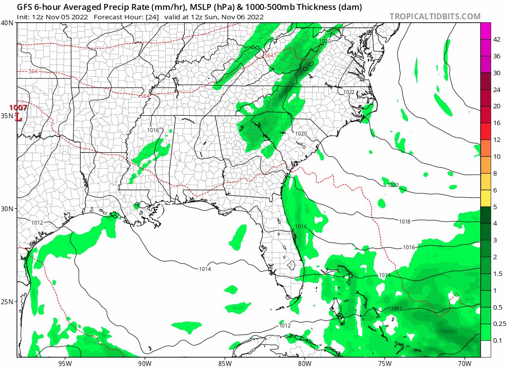
Glad the GFS dropped the idea of a hurricane and joined the rest of the models of moderate STS or TS coming west towards FL, but regardless strong winds and 20'+ waves just offshore will add to the beach erosion problems across east central FL, along with King Tides.
0 likes


Re: Possible Development Near the GA/Bahamas Early Next Week (20/60)
NDG wrote:Glad the GFS dropped the idea of a hurricane and joined the rest of the models of moderate STS or TS coming west towards FL, but regardless strong winds and 20'+ waves just offshore will add to the beach erosion problems across east central FL, along with King Tides.
It still shows a hurricane once it’s in the eastern Gulf according to the 6z GFS. Check your latest sources.
0 likes
-
toad strangler

- S2K Supporter

- Posts: 4546
- Joined: Sun Jul 28, 2013 3:09 pm
- Location: Earth
- Contact:
Re: Possible Development Near the GA/Bahamas Early Next Week (20/60)
NDG wrote:Glad the GFS dropped the idea of a hurricane and joined the rest of the models of moderate STS or TS coming west towards FL, but regardless strong winds and 20'+ waves just offshore will add to the beach erosion problems across east central FL, along with King Tides.
It’s going to be interesting to see if this will be a prolific rain event. Obviously N of whatever flavor Low sets up.
0 likes
My Weather Station
https://www.wunderground.com/dashboard/pws/KFLPORTS603
https://www.wunderground.com/dashboard/pws/KFLPORTS603

Re: Possible Development Near the GA/Bahamas Early Next Week (20/60)
Still showing a hurricane for the Gulf.
Sent from my iPhone using Tapatalk
Sent from my iPhone using Tapatalk
1 likes
Re: Possible Development Near the GA/Bahamas Early Next Week (20/60)
MetroMike wrote:NDG wrote:Glad the GFS dropped the idea of a hurricane and joined the rest of the models of moderate STS or TS coming west towards FL, but regardless strong winds and 20'+ waves just offshore will add to the beach erosion problems across east central FL, along with King Tides.
It still shows a hurricane once it’s in the eastern Gulf according to the 6z GFS. Check your latest sources.
Yes I saw it but I don't believe that will be happening over the eastern GOM, especially being in the GFS's 5+ day range forecast. No other model agrees with it, I am sure it will be dropping that idea as well as we get within the 5 day range.
The Euro has been more consistent in the past 3 runs or so.
0 likes
Re: Possible Development Near the GA/Bahamas Early Next Week (20/60)
toad strangler wrote:NDG wrote:Glad the GFS dropped the idea of a hurricane and joined the rest of the models of moderate STS or TS coming west towards FL, but regardless strong winds and 20'+ waves just offshore will add to the beach erosion problems across east central FL, along with King Tides.
It’s going to be interesting to see if this will be a prolific rain event. Obviously N of whatever flavor Low sets up.
So far the Euro forecasts the most rains for east central FL, that will not be good for the still high St John's river basin.
0 likes

Re: Possible Development Near the GA/Bahamas Early Next Week (20/60)
NDG wrote:MetroMike wrote:NDG wrote:Glad the GFS dropped the idea of a hurricane and joined the rest of the models of moderate STS or TS coming west towards FL, but regardless strong winds and 20'+ waves just offshore will add to the beach erosion problems across east central FL, along with King Tides.
It still shows a hurricane once it’s in the eastern Gulf according to the 6z GFS. Check your latest sources.
Yes I saw it but I don't believe that will be happening over the eastern GOM, especially being in the GFS's 5+ day range forecast. No other model agrees with it, I am sure it will be dropping that idea as well as we get within the 5 day range.
The Euro has been more consistent in the past 3 runs or so.
agreed!
0 likes
-
Blown Away

- S2K Supporter
- Posts: 10253
- Joined: Wed May 26, 2004 6:17 am
Re: Possible Development Near the GA/Bahamas Early Next Week (20/60)
I think there is enough to put an Invest tag here.
0 likes
Hurricane Eye Experience: David 79, Irene 99, Frances 04, Jeanne 04, Wilma 05… Hurricane Brush Experience: Andrew 92, Erin 95, Floyd 99, Matthew 16, Irma 17, Ian 22, Nicole 22…
-
jlauderdal
- S2K Supporter
- Posts: 7240
- Joined: Wed May 19, 2004 5:46 am
- Location: NE Fort Lauderdale
- Contact:
Re: RE: Re: Possible Development Near the GA/Bahamas Early Next Week (20/60)
NHC will take that under advisement. I think we have one this afternoon.Blown Away wrote:
I think there is enough to put an Invest tag here.
0 likes
-
gatorcane

- S2K Supporter
- Posts: 23708
- Age: 48
- Joined: Sun Mar 13, 2005 3:54 pm
- Location: Boca Raton, FL
Re: Possible Development Near the GA/Bahamas Early Next Week (20/60)
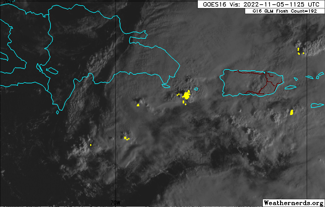
Definite spin south of DR. Looks invest-worthy to me.
1 likes

Re: Possible Development Near the GA/Bahamas Early Next Week (20/60)
New 12Z GFS rolling; Now showing a bit quicker and deeper evolution to "sub 1000mb" at 54 hour forecast time...... interesting
0 likes
Andy D
(For official information, please refer to the NHC and NWS products.)
(For official information, please refer to the NHC and NWS products.)
-
Blown Away
- S2K Supporter
- Posts: 10253
- Joined: Wed May 26, 2004 6:17 am
Re: Possible Development Near the GA/Bahamas Early Next Week (20/60)
12z GFS has near Cat 1 in 72 hrs
0 likes
Hurricane Eye Experience: David 79, Irene 99, Frances 04, Jeanne 04, Wilma 05… Hurricane Brush Experience: Andrew 92, Erin 95, Floyd 99, Matthew 16, Irma 17, Ian 22, Nicole 22…

Re: Possible Development Near the GA/Bahamas Early Next Week (20/60)
NDG wrote:MetroMike wrote:NDG wrote:Glad the GFS dropped the idea of a hurricane and joined the rest of the models of moderate STS or TS coming west towards FL, but regardless strong winds and 20'+ waves just offshore will add to the beach erosion problems across east central FL, along with King Tides.
It still shows a hurricane once it’s in the eastern Gulf according to the 6z GFS. Check your latest sources.
Yes I saw it but I don't believe that will be happening over the eastern GOM, especially being in the GFS's 5+ day range forecast. No other model agrees with it, I am sure it will be dropping that idea as well as we get within the 5 day range.
The Euro has been more consistent in the past 3 runs or so.
Anybody check the ICON model ?
0 likes
-
Blown Away
- S2K Supporter
- Posts: 10253
- Joined: Wed May 26, 2004 6:17 am
Re: Possible Development Near the GA/Bahamas Early Next Week (20/60)
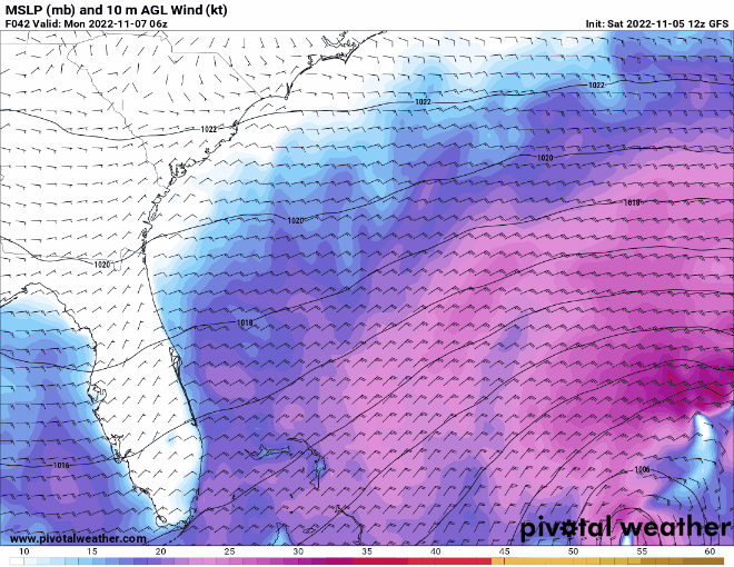
12z GFS back with Cat 1/2 into SFL in 4-5 days..
0 likes
Hurricane Eye Experience: David 79, Irene 99, Frances 04, Jeanne 04, Wilma 05… Hurricane Brush Experience: Andrew 92, Erin 95, Floyd 99, Matthew 16, Irma 17, Ian 22, Nicole 22…
Re: Possible Development Near the GA/Bahamas Early Next Week (20/60)
Latest run pretty much brings (yet to be invest yet) Nicole, more or less over Miami, then Ft. Myers/Sarasota area at in the E. GOM moving northward at 126 hrs. Likely about to turn NNE over Central Fla ahead of the approaching short wave
edit: correction, more like W. Palm then Miami
edit: correction, more like W. Palm then Miami
0 likes
Andy D
(For official information, please refer to the NHC and NWS products.)
(For official information, please refer to the NHC and NWS products.)
Re: Possible Development Near the GA/Bahamas Early Next Week (20/60)
If things pan out the way GFS thinks it will, the storm would probably be too small for the GFS to really resolve the actual low pressure. In other words, that landfall in the 12z ain't gunna be 980mb.
0 likes

Re: Possible Development Near the GA/Bahamas Early Next Week (20/60)
The way this is firing in the Mona passage, it may stack earlier than expected.
And the way the GFS is trending, not looking too good for FL.
And the way the GFS is trending, not looking too good for FL.
1 likes
-
Blown Away
- S2K Supporter
- Posts: 10253
- Joined: Wed May 26, 2004 6:17 am
Re: Possible Development Near the GA/Bahamas Early Next Week (20/60)
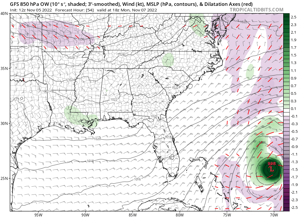
12z GFS.
1 likes
Hurricane Eye Experience: David 79, Irene 99, Frances 04, Jeanne 04, Wilma 05… Hurricane Brush Experience: Andrew 92, Erin 95, Floyd 99, Matthew 16, Irma 17, Ian 22, Nicole 22…
Re: Possible Development Near the GA/Bahamas Early Next Week (20/60)
CMC agrees on hurricane, thinks ridge weak and heads to Carolinas.
edit, well actually maybe heading to Canada as a hybrid storm? Wonder how much snow this means?
edit, well actually maybe heading to Canada as a hybrid storm? Wonder how much snow this means?
Last edited by shah83 on Sat Nov 05, 2022 11:23 am, edited 1 time in total.
0 likes
-
SouthFLTropics

- Category 5

- Posts: 4258
- Age: 50
- Joined: Thu Aug 14, 2003 8:04 am
- Location: Port St. Lucie, Florida
Re: Possible Development Near the GA/Bahamas Early Next Week (20/60)
12z CMC is trending stronger but turns it north just before reaching the east Florida coast.
Sent from my iPhone using Tapatalk
Sent from my iPhone using Tapatalk
0 likes
Fourth Generation Florida Native
Personal Storm History: David 79, Andrew 92, Erin 95, Floyd 99, Irene 99, Frances 04, Jeanne 04, Wilma 05, Matthew 16, Irma 17, Ian 22, Nicole 22, Milton 24
Personal Storm History: David 79, Andrew 92, Erin 95, Floyd 99, Irene 99, Frances 04, Jeanne 04, Wilma 05, Matthew 16, Irma 17, Ian 22, Nicole 22, Milton 24
Who is online
Users browsing this forum: No registered users and 194 guests