
Possible Development Near the GA/Bahamas (Is Invest 98L)
Moderator: S2k Moderators
Forum rules

The posts in this forum are NOT official forecasts and should not be used as such. They are just the opinion of the poster and may or may not be backed by sound meteorological data. They are NOT endorsed by any professional institution or STORM2K. For official information, please refer to products from the National Hurricane Center and National Weather Service.
-
AJC3

- Admin

- Posts: 4153
- Age: 62
- Joined: Tue Aug 31, 2004 7:04 pm
- Location: Ballston Spa, New York
- Contact:
Re: Possible Development Near the GA/Bahamas (50/80)
What's the under/over on the number of times the "Yankee" Hurricane gets referenced over the next 5 days?
6 likes

Re: Possible Development Near the GA/Bahamas (50/80)
GEFS still further SW versus OPS run.

2 likes
The following post is NOT an official forecast and should not be used as such. It is just the opinion of the poster and may or may not be backed by sound meteorological data. It is NOT endorsed by any professional institution including storm2k.org For Official Information please refer to the NHC and NWS products.
-
Blown Away

- S2K Supporter

- Posts: 10253
- Joined: Wed May 26, 2004 6:17 am
Re: Possible Development Near the GA/Bahamas (50/80)
AJC3 wrote:What's the under/over on the number of times the "Yankee" Hurricane gets referenced over the next 5 days?
https://i.imgur.com/C6Fb6Jx.png
I love FL climatology, so I would have mentioned at least once.
2 likes
Hurricane Eye Experience: David 79, Irene 99, Frances 04, Jeanne 04, Wilma 05… Hurricane Brush Experience: Andrew 92, Erin 95, Floyd 99, Matthew 16, Irma 17, Ian 22, Nicole 22…
-
Blown Away
- S2K Supporter
- Posts: 10253
- Joined: Wed May 26, 2004 6:17 am
Re: Possible Development Near the GA/Bahamas (50/80)
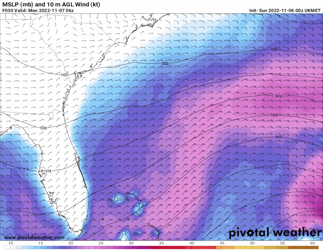
00z Ukmet…
1 likes
Hurricane Eye Experience: David 79, Irene 99, Frances 04, Jeanne 04, Wilma 05… Hurricane Brush Experience: Andrew 92, Erin 95, Floyd 99, Matthew 16, Irma 17, Ian 22, Nicole 22…
-
Blown Away
- S2K Supporter
- Posts: 10253
- Joined: Wed May 26, 2004 6:17 am
Re: Possible Development Near the GA/Bahamas (50/80)
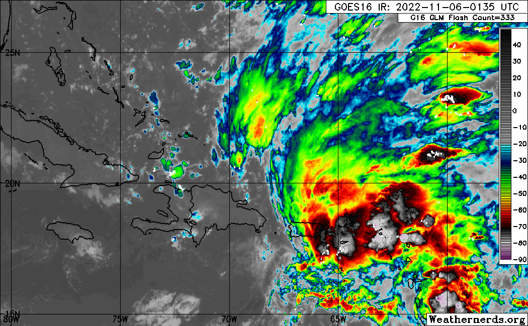
Latest… Getting the look…
2 likes
Hurricane Eye Experience: David 79, Irene 99, Frances 04, Jeanne 04, Wilma 05… Hurricane Brush Experience: Andrew 92, Erin 95, Floyd 99, Matthew 16, Irma 17, Ian 22, Nicole 22…
-
Blown Away
- S2K Supporter
- Posts: 10253
- Joined: Wed May 26, 2004 6:17 am
Re: Possible Development Near the GA/Bahamas (50/80)
blp wrote:GEFS still further SW versus OPS run.
https://i.ibb.co/dQVLqk1/gfs-ens-z850-vort-eus-19.png
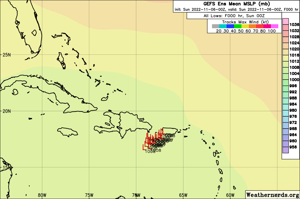
00z GEFS… Seeing more oranges in each of the past 3 runs…
Last edited by Blown Away on Sun Nov 06, 2022 12:05 am, edited 1 time in total.
0 likes
Hurricane Eye Experience: David 79, Irene 99, Frances 04, Jeanne 04, Wilma 05… Hurricane Brush Experience: Andrew 92, Erin 95, Floyd 99, Matthew 16, Irma 17, Ian 22, Nicole 22…
-
AutoPenalti
- Category 5

- Posts: 4091
- Age: 29
- Joined: Mon Aug 17, 2015 4:16 pm
- Location: Ft. Lauderdale, Florida
Re: Possible Development Near the GA/Bahamas (50/80)
Look for the ULAC to establish overnight.
0 likes
The posts in this forum are NOT official forecasts and should not be used as such. They are just the opinion of the poster and may or may not be backed by sound meteorological data. They are NOT endorsed by any professional institution or STORM2K. For official information, please refer to products from the NHC and NWS.
Model Runs Cheat Sheet:
GFS (5:30 AM/PM, 11:30 AM/PM)
HWRF, GFDL, UKMET, NAVGEM (6:30-8:00 AM/PM, 12:30-2:00 AM/PM)
ECMWF (1:45 AM/PM)
TCVN is a weighted averaged


Re: Possible Development Near the GA/Bahamas (50/80)
AutoPenalti wrote:Look for the ULAC to establish overnight.
Can you explain ULAC? Google does not help me.
0 likes
-
REDHurricane

- Category 1

- Posts: 438
- Age: 28
- Joined: Sun Jul 03, 2022 2:36 pm
- Location: Northeast Pacific Ocean
Re: Possible Development Near the GA/Bahamas (50/80)
IIRC way back in August/September the CFS long range was consistently predicting something very similar to this exact setup happening in early November, but I don't have any model runs saved to show what I'm thinking of -- does anyone else remember this?
0 likes
-
REDHurricane
- Category 1
- Posts: 438
- Age: 28
- Joined: Sun Jul 03, 2022 2:36 pm
- Location: Northeast Pacific Ocean
Re: Possible Development Near the GA/Bahamas (50/80)
MetroMike wrote:AutoPenalti wrote:Look for the ULAC to establish overnight.
Can you explain ULAC? Google does not help me.
upper level anticyclone, when the higher levels of the atmosphere are rotating clockwise, generally helps tropical cyclones form because it provides a mechanism for efficient energy outflow and lowers upper level wind shear cutting across the top of the storm
Last edited by REDHurricane on Sun Nov 06, 2022 12:58 am, edited 1 time in total.
3 likes
-
Stormi

- Tropical Depression

- Posts: 86
- Age: 38
- Joined: Sun Aug 18, 2019 10:04 pm
- Location: Northeast FL
Re: Possible Development Near the GA/Bahamas (50/80)
ULAC - Upper-level anti-cyclone.
It essentially aids in ventilating the storm.
It essentially aids in ventilating the storm.
2 likes
Re: Possible Development Near the GA/Bahamas (50/80)
Incoming ..

0 likes
The following post is NOT an official forecast and should not be used as such. It is just the opinion of the poster and may or may not be backed by sound meteorological data. It is NOT endorsed by any professional institution including storm2k.org For Official Information please refer to the NHC and NWS products.

Re: Possible Development Near the GA/Bahamas (50/80)
Wow are those concerning model runs for South FL 
This is about as nuts as it gets during November for this part of the Atlantic, almost seems like we could see something similar to the 1935 Yankee Hurricane. Looks like it could be more than just rain and wind if the trend keeps like this.
This is about as nuts as it gets during November for this part of the Atlantic, almost seems like we could see something similar to the 1935 Yankee Hurricane. Looks like it could be more than just rain and wind if the trend keeps like this.
2 likes
Georges '98, Irene '99, Frances '04, Jeanne '04, Katrina '05, Wilma '05, Gustav '08, Isaac '12, Matthew '16, Florence '18, Michael '18, Ian '22
-
Blown Away
- S2K Supporter
- Posts: 10253
- Joined: Wed May 26, 2004 6:17 am
Re: Possible Development Near the GA/Bahamas (50/80)
00z EURO… 997mb at @Ft Lauderdale landfall in @4 days… Much deeper/stronger than all previous runs…
1 likes
Hurricane Eye Experience: David 79, Irene 99, Frances 04, Jeanne 04, Wilma 05… Hurricane Brush Experience: Andrew 92, Erin 95, Floyd 99, Matthew 16, Irma 17, Ian 22, Nicole 22…
Re: Possible Development Near the GA/Bahamas (50/80)
1. The last few runs of models all have a TC eventually. So, I don't think we're looking at just the STC option any more.
2. Now that we're closer, it appears that the wx on Election Day will not be that bad in the SE US (other than coastal/marine).
3. However, the models are now all progging a TS or hurricane vs many not doing that before. Any direct impact to the SE US from this wouldn't start before Wednesday afternoon or Wednesday night. IF there later really is a hurricane that is progged to start directly impacting FL (SE or further north depending on what track it takes) Wednesday PM and keeping in mind the panic and prep that always occurs 1-2 days before in addition to evacuations, what do folks here think will happen as regards Election Day, which has its own chaos? Wednesday would already be too late for the most part with it starting to come in late that day. Does anyone think it will have to be postponed in Florida? Keep in mind that this situation would be totally unprecedented. I've yet to see anyone say anything about this.
Earlier when I was thinking about Election Day, I was thinking only about reduced turnout possibilities due to inclement wx on that day. Now it is potentially a much bigger deal than that.
7 likes
Personal Forecast Disclaimer:
The posts in this forum are NOT official forecasts and should not be used as such. They are just the opinion of the poster and may or may not be backed by sound meteorological data. They are NOT endorsed by any professional institution or storm2k.org. For official information, please refer to the NHC and NWS products.
The posts in this forum are NOT official forecasts and should not be used as such. They are just the opinion of the poster and may or may not be backed by sound meteorological data. They are NOT endorsed by any professional institution or storm2k.org. For official information, please refer to the NHC and NWS products.
-
Blown Away
- S2K Supporter
- Posts: 10253
- Joined: Wed May 26, 2004 6:17 am
Re: Possible Development Near the GA/Bahamas (50/80)
LarryWx wrote:1. The last few runs of models all have a TC eventually. So, I don't think we're looking at just the STC option any more.
2. Now that we're closer, it appears that the wx on Election Day will not be that bad in the SE US (other than coastal/marine).
3. However, the models are now all progging a TS or hurricane vs many not doing that before. Any direct impact to the SE US from this wouldn't start before Wednesday afternoon or Wednesday night. IF there later really is a hurricane that is progged to start directly impacting FL (SE or further north depending on what track it takes) Wednesday PM and keeping in mind the panic and prep that always occurs 1-2 days before in addition to evacuations, what do folks here think will happen as regards Election Day, which has its own chaos? Wednesday would already be too late for the most part with it starting to come in late that day. Does anyone think it will have to be postponed in Florida? Keep in mind that this situation would be totally unprecedented. I've yet to see anyone say anything about this.
00z runs all looked tropical instead of STS.
IF Euro is right TS conditions likely start Wednesday late afternoon in SFL, maybe the tight pressure gradient will enhance this?
OMG, the election madness!
I’m a big believer in Climatology and I struggle to support something that happens once every @40+ years. My climatology dependency has been proven wrong several times in recent years.
4 likes
Hurricane Eye Experience: David 79, Irene 99, Frances 04, Jeanne 04, Wilma 05… Hurricane Brush Experience: Andrew 92, Erin 95, Floyd 99, Matthew 16, Irma 17, Ian 22, Nicole 22…
-
eastcoastFL

- Category 5
- Posts: 3996
- Age: 44
- Joined: Thu Apr 12, 2007 12:29 pm
- Location: Palm City, FL
Re: Possible Development Near the GA/Bahamas (50/80)

1 likes
Personal Forecast Disclaimer:
The posts in this forum are NOT official forecast and should not be used as such. They are just the opinion of the poster and may or may not be backed by sound meteorological data. They are NOT endorsed by any professional institution or storm2k.org. For official information, please refer to the NHC and NWS products.
The posts in this forum are NOT official forecast and should not be used as such. They are just the opinion of the poster and may or may not be backed by sound meteorological data. They are NOT endorsed by any professional institution or storm2k.org. For official information, please refer to the NHC and NWS products.
-
jlauderdal
- S2K Supporter
- Posts: 7240
- Joined: Wed May 19, 2004 5:46 am
- Location: NE Fort Lauderdale
- Contact:
Re: RE: Re: Possible Development Near the GA/Bahamas (50/80)
Nah, it wont verify..too much ridging, it will be southBlown Away wrote:
00z EURO… 997mb at @Ft Lauderdale landfall in @4 days… Much deeper/stronger than all previous runs…
0 likes
-
eastcoastFL
- Category 5
- Posts: 3996
- Age: 44
- Joined: Thu Apr 12, 2007 12:29 pm
- Location: Palm City, FL
Re: Possible Development Near the GA/Bahamas (50/80)
Guess I’ll hit the stores in the morning and grab some water just incase before the mobs do when it hits the news. This is kinda nuts, a November east coast hurricane threat. I’m shocked this isn’t an invest yet, especially with the model support.
2 likes
Personal Forecast Disclaimer:
The posts in this forum are NOT official forecast and should not be used as such. They are just the opinion of the poster and may or may not be backed by sound meteorological data. They are NOT endorsed by any professional institution or storm2k.org. For official information, please refer to the NHC and NWS products.
The posts in this forum are NOT official forecast and should not be used as such. They are just the opinion of the poster and may or may not be backed by sound meteorological data. They are NOT endorsed by any professional institution or storm2k.org. For official information, please refer to the NHC and NWS products.
-
AxaltaRacing24
- Category 5
- Posts: 1774
- Age: 25
- Joined: Wed Jul 27, 2016 11:14 am
- Location: Jupiter, FL
Re: Possible Development Near the GA/Bahamas (50/80)
eastcoastFL wrote:Guess I’ll hit the stores in the morning and grab some water just incase before the mobs do when it hits the news. This is kinda nuts, a November east coast hurricane threat. I’m shocked this isn’t an invest yet, especially with the model support.
Kinda nuts? This doesn't feel real lol
1 likes
Who is online
Users browsing this forum: No registered users and 49 guests