ATL: NICOLE - Models
Moderator: S2k Moderators
-
Blown Away

- S2K Supporter

- Posts: 10253
- Joined: Wed May 26, 2004 6:17 am
Re: ATL: INVEST 98L - Models
06z EURO… Same as 00z
0 likes
Hurricane Eye Experience: David 79, Irene 99, Frances 04, Jeanne 04, Wilma 05… Hurricane Brush Experience: Andrew 92, Erin 95, Floyd 99, Matthew 16, Irma 17, Ian 22, Nicole 22…
-
cycloneye

- Admin

- Posts: 149727
- Age: 69
- Joined: Thu Oct 10, 2002 10:54 am
- Location: San Juan, Puerto Rico
Re: ATL: INVEST 98L - Models

0 likes
Visit the Caribbean-Central America Weather Thread where you can find at first post web cams,radars
and observations from Caribbean basin members Click Here
and observations from Caribbean basin members Click Here
-
gatorcane

- S2K Supporter
- Posts: 23708
- Age: 48
- Joined: Sun Mar 13, 2005 3:54 pm
- Location: Boca Raton, FL
Re: ATL: INVEST 98L - Models
SHIPS and IVCN bring this to a hurricane, we will see in the 18Z guidance some more models like the HWRF

1 likes
-
Blown Away
- S2K Supporter
- Posts: 10253
- Joined: Wed May 26, 2004 6:17 am
Re: ATL: INVEST 98L - Models
06z ICON… Significant shift SW and much stronger.
0 likes
Hurricane Eye Experience: David 79, Irene 99, Frances 04, Jeanne 04, Wilma 05… Hurricane Brush Experience: Andrew 92, Erin 95, Floyd 99, Matthew 16, Irma 17, Ian 22, Nicole 22…
-
Blown Away
- S2K Supporter
- Posts: 10253
- Joined: Wed May 26, 2004 6:17 am
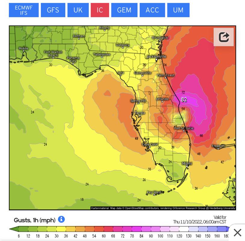
Re: ATL: INVEST 98L - Models
12z ICON… Another SW shift with Cat 1 into Port St. Lucie..
0 likes
Hurricane Eye Experience: David 79, Irene 99, Frances 04, Jeanne 04, Wilma 05… Hurricane Brush Experience: Andrew 92, Erin 95, Floyd 99, Matthew 16, Irma 17, Ian 22, Nicole 22…
-
Hypercane_Kyle

- Category 5

- Posts: 3465
- Joined: Sat Mar 07, 2015 7:58 pm
- Location: Cape Canaveral, FL
Re: ATL: INVEST 98L - Models
Thus far, 12z GFS is just ever so slightly north of 06z. Continuing with a stronger solution when compared to the Euro and CMC.
0 likes
My posts are my own personal opinion, defer to the National Hurricane Center (NHC) and other NOAA products for decision making during hurricane season.


Re: ATL: INVEST 98L - Models
12z GFS through 84 hrs.
Through 104 hours

Through 104 hours
Last edited by NDG on Sun Nov 06, 2022 11:03 am, edited 1 time in total.
0 likes
-
Blown Away
- S2K Supporter
- Posts: 10253
- Joined: Wed May 26, 2004 6:17 am
Re: ATL: INVEST 98L - Models
Very large wind field!! 
0 likes
Hurricane Eye Experience: David 79, Irene 99, Frances 04, Jeanne 04, Wilma 05… Hurricane Brush Experience: Andrew 92, Erin 95, Floyd 99, Matthew 16, Irma 17, Ian 22, Nicole 22…


Re: ATL: INVEST 98L - Models
Blown Away wrote:[url]https://i.postimg.cc/yx8jGJc1/015-B0-D02-59-A9-4-E5-D-A44-E-54-E9-A6-E749-FE.jpg [/url]
12z ICON… Another SW shift with Cat 1 into Port St. Lucie..
ICON model is not really held in high regard and not used by the NHC for forecasting.
0 likes

-
jlauderdal
- S2K Supporter
- Posts: 7240
- Joined: Wed May 19, 2004 5:46 am
- Location: NE Fort Lauderdale
- Contact:
Re: RE: Re: ATL: INVEST 98L - Models
Easy drive up 95 for landfall.NDG wrote:12z GFS through 84 hrs.
Through 104 hours
1 likes
Re: ATL: INVEST 98L - Models
12Z CMC is consistent with earlier runs on bringing this in further north (Daytona). But the CMC is not a reliable model and often is lousy.
0 likes
Personal Forecast Disclaimer:
The posts in this forum are NOT official forecasts and should not be used as such. They are just the opinion of the poster and may or may not be backed by sound meteorological data. They are NOT endorsed by any professional institution or storm2k.org. For official information, please refer to the NHC and NWS products.
The posts in this forum are NOT official forecasts and should not be used as such. They are just the opinion of the poster and may or may not be backed by sound meteorological data. They are NOT endorsed by any professional institution or storm2k.org. For official information, please refer to the NHC and NWS products.
Re: ATL: INVEST 98L - Models
LarryWx wrote:12Z CMC is consistent with earlier runs on bringing this in further north (Daytona). But the CMC is not a reliable model and often is lousy.
Actually it shows landfall over FL for the first time, previous runs had it staying offshore. So is fair to say that it keeps trending west.

0 likes
Re: ATL: INVEST 98L - Models
12Z UKMET landfalls near Stuart, FL, Thursday morning. It then goes WNW across C FL to the NE GOM followed by a sharp recurve to just off the SC coast as a somewhat restrengthening storm (becoming extratropical then?):
NEW TROPICAL CYCLONE FORECAST TO DEVELOP AFTER 24 HOURS
FORECAST POSITION AT T+ 24 : 24.7N 69.3W
LEAD CENTRAL MAXIMUM WIND
VERIFYING TIME TIME POSITION PRESSURE (MB) SPEED (KNOTS)
-------------- ---- -------- ------------- -------------
1200UTC 07.11.2022 24 24.7N 69.3W 1005 33
0000UTC 08.11.2022 36 25.9N 70.1W 1003 40
1200UTC 08.11.2022 48 27.0N 70.8W 1004 34
0000UTC 09.11.2022 60 27.0N 72.9W 1004 39
1200UTC 09.11.2022 72 26.1N 75.3W 1002 43
0000UTC 10.11.2022 84 25.8N 77.4W 1002 40
1200UTC 10.11.2022 96 26.9N 79.7W 1000 38
0000UTC 11.11.2022 108 28.0N 82.2W 997 36
1200UTC 11.11.2022 120 29.1N 83.6W 999 27
0000UTC 12.11.2022 132 30.6N 82.7W 1000 27
1200UTC 12.11.2022 144 32.7N 79.2W 997 38
I'd ignore the wind speed forecast as the UKMET always is too low in the early stages. The track is what is most important.
0 likes
Personal Forecast Disclaimer:
The posts in this forum are NOT official forecasts and should not be used as such. They are just the opinion of the poster and may or may not be backed by sound meteorological data. They are NOT endorsed by any professional institution or storm2k.org. For official information, please refer to the NHC and NWS products.
The posts in this forum are NOT official forecasts and should not be used as such. They are just the opinion of the poster and may or may not be backed by sound meteorological data. They are NOT endorsed by any professional institution or storm2k.org. For official information, please refer to the NHC and NWS products.

Re: ATL: INVEST 98L - Models
miami on south looks safe, at least on the weak side of storm....
0 likes

Re: ATL: INVEST 98L - Models
mantis83 wrote:miami on south looks safe, at least on the weak side of storm....
Not yet. The SW jog could take longer and it could come further south before making the West turn. Just like with Ian we probably won't know until this thing is 24hrs out that is how close this is. I have seen the SW dive be a little unpredictable in the past.
1 likes
The following post is NOT an official forecast and should not be used as such. It is just the opinion of the poster and may or may not be backed by sound meteorological data. It is NOT endorsed by any professional institution including storm2k.org For Official Information please refer to the NHC and NWS products.
-
Blown Away
- S2K Supporter
- Posts: 10253
- Joined: Wed May 26, 2004 6:17 am
Re: ATL: INVEST 98L - Models
blp wrote:mantis83 wrote:miami on south looks safe, at least on the weak side of storm....
Not yet. The SW jog could take longer and it could come further south before making the West turn. Just like with Ian we probably won't know until this thing is 24hrs out that is how close this is. I have seen the SW dive be a little unpredictable in the past.
IMO, no way, that big jump N might be a bit smoother and not gain as much latitude which would bring 98L to SFL a bit sooner which likely comes S.
Last edited by Blown Away on Sun Nov 06, 2022 11:57 am, edited 1 time in total.
0 likes
Hurricane Eye Experience: David 79, Irene 99, Frances 04, Jeanne 04, Wilma 05… Hurricane Brush Experience: Andrew 92, Erin 95, Floyd 99, Matthew 16, Irma 17, Ian 22, Nicole 22…
Who is online
Users browsing this forum: No registered users and 37 guests