39 hours:
ATL: NICOLE - Models
Moderator: S2k Moderators
-
gatorcane

- S2K Supporter

- Posts: 23708
- Age: 48
- Joined: Sun Mar 13, 2005 3:54 pm
- Location: Boca Raton, FL
Re: ATL: NICOLE - Models
18Z ICON slight south shift and 1MB stronger out through 18 hours so far
39 hours:
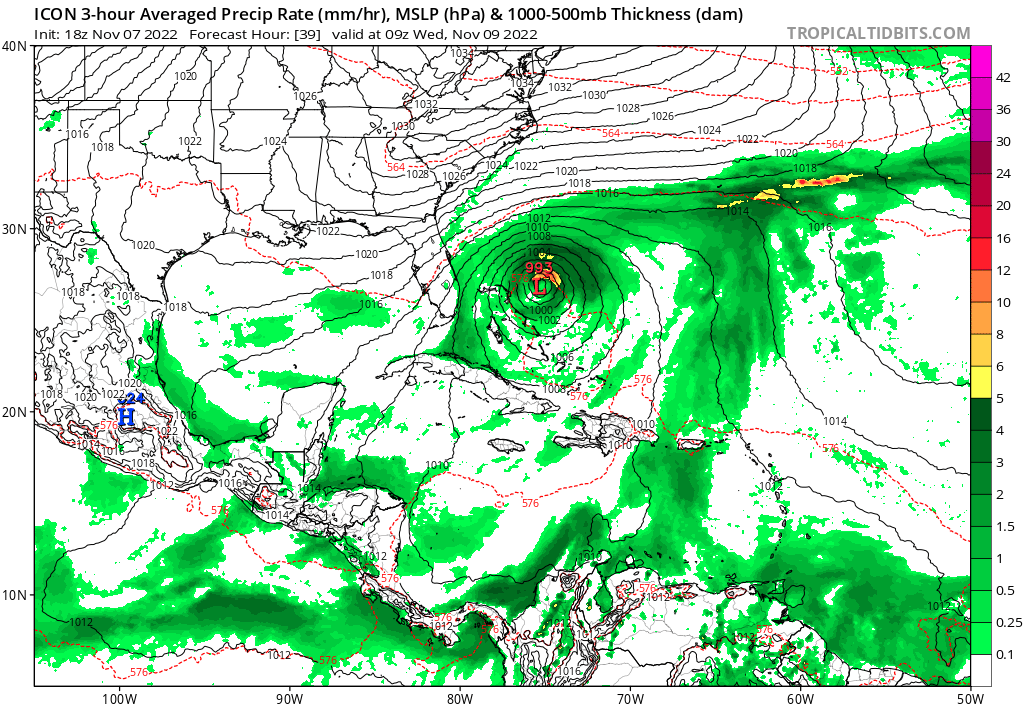
39 hours:
2 likes
-
Stormlover1970
- Tropical Low

- Posts: 32
- Age: 56
- Joined: Sun May 22, 2022 9:26 am
- Location: New Port Richey, Florida
Re: ATL: NICOLE - Models
the nam is spamgatorcane wrote:18Z NAM shifts south a bit, landfall WPB:
https://i.postimg.cc/CMCsFPQ9/nam-mslp-pcpn-watl-19.png

1 likes
-
jlauderdal
- S2K Supporter
- Posts: 7240
- Joined: Wed May 19, 2004 5:46 am
- Location: NE Fort Lauderdale
- Contact:
Re: ATL: NICOLE - Models
gatorcane wrote:18Z NAM shifts south a bit, landfall WPB:
https://i.postimg.cc/CMCsFPQ9/nam-mslp-pcpn-watl-19.png
That is concerning for the residents of Boca.
0 likes

Re: ATL: NICOLE - Models
I wonder how models take into account gradient features both in wind strength and direction. Must add something different into the mix not always dealt ?
0 likes

Re: ATL: NICOLE - Models
BobHarlem wrote:18z Icon, stronger with landfall in Palm Bay.
https://i.imgur.com/kblJxmW.png
Well see if ICON can pull off two in a row it definitely is predicting a more northern landfall than the Euro or Gfs.
1 likes
-
AutoPenalti
- Category 5

- Posts: 4091
- Age: 29
- Joined: Mon Aug 17, 2015 4:16 pm
- Location: Ft. Lauderdale, Florida
Re: ATL: NICOLE - Models
cane5 wrote:BobHarlem wrote:18z Icon, stronger with landfall in Palm Bay.
https://i.imgur.com/kblJxmW.png
Well see if ICON can pull off two in a row it definitely is predicting a more northern landfall than the Euro or Gfs.
It actually shifted South.
0 likes
The posts in this forum are NOT official forecasts and should not be used as such. They are just the opinion of the poster and may or may not be backed by sound meteorological data. They are NOT endorsed by any professional institution or STORM2K. For official information, please refer to products from the NHC and NWS.
Model Runs Cheat Sheet:
GFS (5:30 AM/PM, 11:30 AM/PM)
HWRF, GFDL, UKMET, NAVGEM (6:30-8:00 AM/PM, 12:30-2:00 AM/PM)
ECMWF (1:45 AM/PM)
TCVN is a weighted averaged
Re: ATL: NICOLE - Models
AutoPenalti wrote:cane5 wrote:BobHarlem wrote:18z Icon, stronger with landfall in Palm Bay.
https://i.imgur.com/kblJxmW.png
Well see if ICON can pull off two in a row it definitely is predicting a more northern landfall than the Euro or Gfs.
It actually shifted South.
Not by too much interesting to see the next run…
0 likes
-
gatorcane
- S2K Supporter
- Posts: 23708
- Age: 48
- Joined: Sun Mar 13, 2005 3:54 pm
- Location: Boca Raton, FL
Re: ATL: NICOLE - Models
The GFS shifted south by a little now just south of WPB at landfall in Palm Beach County. Maybe over SFLcane’s house. Looks like Lake Worth or Boynton Beach.
1 likes
-
Blown Away

- S2K Supporter
- Posts: 10253
- Joined: Wed May 26, 2004 6:17 am
Re: ATL: NICOLE - Models
gatorcane wrote:The GFS shifted south by a little now just south of WPB at landfall in Palm Beach County. Maybe over SFLcane’s house. Looks like Lake Worth or Boynton Beach.
https://i.postimg.cc/0NLvkdNH/gfs-mslp-wind-seus-fh0-60.gif
That's a big shift in close range and stronger!
0 likes
Hurricane Eye Experience: David 79, Irene 99, Frances 04, Jeanne 04, Wilma 05… Hurricane Brush Experience: Andrew 92, Erin 95, Floyd 99, Matthew 16, Irma 17, Ian 22, Nicole 22…
-
jlauderdal
- S2K Supporter
- Posts: 7240
- Joined: Wed May 19, 2004 5:46 am
- Location: NE Fort Lauderdale
- Contact:
Re: RE: Re: ATL: NICOLE - Models
You getting ready for an eyewall?Blown Away wrote:gatorcane wrote:The GFS shifted south by a little now just south of WPB at landfall in Palm Beach County. Maybe over SFLcane’s house. Looks like Lake Worth or Boynton Beach.
https://i.postimg.cc/0NLvkdNH/gfs-mslp-wind-seus-fh0-60.gif
That's a big shift in close range and stronger!
0 likes

Re: ATL: NICOLE - Models
18z GFS with a shift west on landfall in the Gulf

Sent from my iPhone using Tapatalk
Sent from my iPhone using Tapatalk
0 likes
-
SFLcane

- S2K Supporter
- Posts: 10281
- Age: 48
- Joined: Sat Jun 05, 2010 1:44 pm
- Location: Lake Worth Florida
Re: ATL: NICOLE - Models
gatorcane wrote:The GFS shifted south by a little now just south of WPB at landfall in Palm Beach County. Maybe over SFLcane’s house. Looks like Lake Worth or Boynton Beach.
https://i.postimg.cc/0NLvkdNH/gfs-mslp-wind-seus-fh0-60.gif
2 likes

Re: ATL: NICOLE - Models
Well at least Navgem still shows a recurve. Something to build on while the rest of the models want to pummel Florida!
https://www.tropicaltidbits.com/analysi ... 0706&fh=63
https://www.tropicaltidbits.com/analysi ... 0706&fh=63
0 likes
The following post is NOT an official forecast and should not be used as such. It is just the opinion of the poster and may or may not be backed by sound meteorological data. It is NOT endorsed by any professional institution including storm2k.org For Official Information please refer to the NHC and NWS products.
-
Blown Away
- S2K Supporter
- Posts: 10253
- Joined: Wed May 26, 2004 6:17 am
Re: ATL: NICOLE - Models
N2FSU wrote:18z GFS with a shift west on landfall in the Gulfhttps://uploads.tapatalk-cdn.com/20221107/46441c99fff8d6d8cbcf2c9c58e6866a.jpeg
https://uploads.tapatalk-cdn.com/20221107/428a26f9f44a006ead2041cbae51c956.jpeg
Sent from my iPhone using Tapatalk
Hurricanes are mad at FSU and coming your way!
2 likes
Hurricane Eye Experience: David 79, Irene 99, Frances 04, Jeanne 04, Wilma 05… Hurricane Brush Experience: Andrew 92, Erin 95, Floyd 99, Matthew 16, Irma 17, Ian 22, Nicole 22…

Re: ATL: NICOLE - Models
Salute!
I feel SFL will do just fine....an accomplished storm vet and more prepared than 99% of the U.S. population for a storm.
Biggie where SFL lives is height above sea level and prep fpr power loss. Looks like most of that neighborhood is over 20 feet above sea level, and no big waves crashing on the house that is 100 feet from the beach!
One more time... get those poptarts and beer early!
Gums sends...
1 likes
-
Blown Away
- S2K Supporter
- Posts: 10253
- Joined: Wed May 26, 2004 6:17 am
Re: ATL: NICOLE - Models

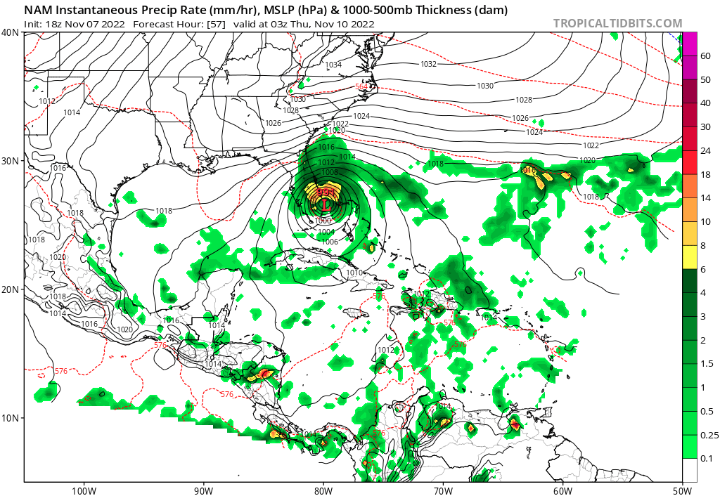
18z NAM... Just because...
1 likes
Hurricane Eye Experience: David 79, Irene 99, Frances 04, Jeanne 04, Wilma 05… Hurricane Brush Experience: Andrew 92, Erin 95, Floyd 99, Matthew 16, Irma 17, Ian 22, Nicole 22…
-
AtlanticWind

- S2K Supporter
- Posts: 1898
- Age: 67
- Joined: Sun Aug 08, 2004 9:57 pm
- Location: Plantation,Fla
Re: ATL: NICOLE - Models
sponger wrote:Well at least Navgem still shows a recurve. Something to build on while the rest of the models want to pummel Florida!
https://www.tropicaltidbits.com/analysi ... 0706&fh=63
Thats the 6z , the 12z joins other models with Florida landfall
1 likes
Re: ATL: NICOLE - Models
AtlanticWind wrote:sponger wrote:Well at least Navgem still shows a recurve. Something to build on while the rest of the models want to pummel Florida!
https://www.tropicaltidbits.com/analysi ... 0706&fh=63
Thats the 6z , the 12z joins other models with Florida landfall
Well so much for that! I think the risks for a Cat 2 landfall are going up. I would be preparing as such from North Dade to the Cape.
0 likes
The following post is NOT an official forecast and should not be used as such. It is just the opinion of the poster and may or may not be backed by sound meteorological data. It is NOT endorsed by any professional institution including storm2k.org For Official Information please refer to the NHC and NWS products.
Re: ATL: NICOLE - Models
Blown Away wrote:https://i.imgur.com/0tYc6Lo.gif
18z NAM... Just because...
That is insane! Imagine if that verified! One thing is for sure, that is one seriously strong high for November! Truly a crazy year or two for weather!
1 likes
The following post is NOT an official forecast and should not be used as such. It is just the opinion of the poster and may or may not be backed by sound meteorological data. It is NOT endorsed by any professional institution including storm2k.org For Official Information please refer to the NHC and NWS products.
Who is online
Users browsing this forum: No registered users and 11 guests