
https://twitter.com/WxTca/status/1615056454557536259
https://twitter.com/RyanMaue/status/1615065149118812165
https://twitter.com/burgwx/status/1615061746590355456
Suptropical Storm 1 (Upgraded in Pre-season Reanalysis)
Moderator: S2k Moderators
Re: ATL: INVEST 90L - Discussion
0 likes
TC naming lists: retirements and intensity
Most aggressive Advisory #1's in North Atlantic (cr. kevin for starting the list)
Most aggressive Advisory #1's in North Atlantic (cr. kevin for starting the list)
-
Sciencerocks
- Category 5

- Posts: 10181
- Age: 40
- Joined: Thu Jul 06, 2017 1:51 am
Re: ATL: INVEST 90L - Discussion
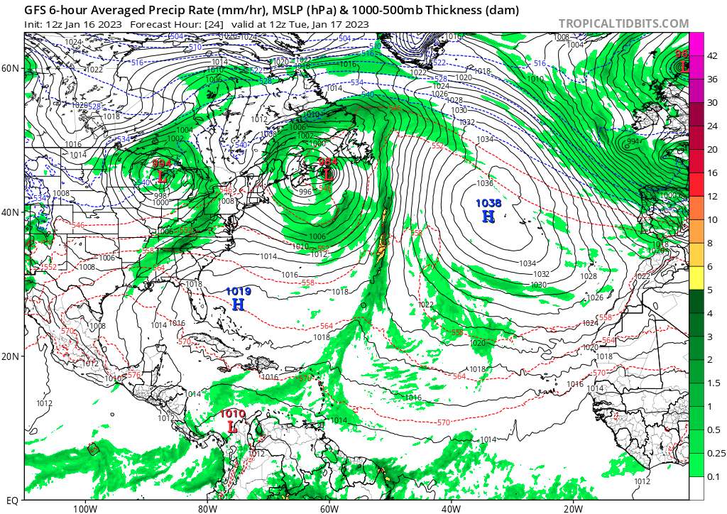
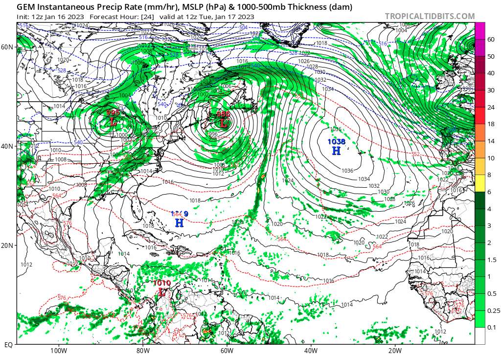
This isn't a fish or non-threat to land either. Models do show it making landfall. Tropical storm or hurricane warnings are needed.
Last edited by Sciencerocks on Mon Jan 16, 2023 4:17 pm, edited 2 times in total.
2 likes

-
wxman57

- Moderator-Pro Met

- Posts: 23172
- Age: 68
- Joined: Sat Jun 21, 2003 8:06 pm
- Location: Houston, TX (southwest)
Re: Low Pressure Off the Mid Atlantic Coast (is INVEST 90L)
Category5Kaiju wrote:Very curious to see what happens within the next day or so. You would think if it persists and becomes better looking that the NHC may be forced to reconsider?
It has no time. By sunrise tomorrow it will be moving across the eastern tip of Nova Scotia as a weakening storm with possibly 35kt wind.
0 likes
-
Hurricane2022

- Category 5
- Posts: 2016
- Joined: Tue Aug 23, 2022 11:38 pm
- Location: Araçatuba, Brazil
Re: ATL: INVEST 90L - Discussion
1. No additional Special Tropical Weather Outlooks are scheduled for
this system. Regularly scheduled Tropical Weather Outlooks will
resume on May 15, 2023, while Special Tropical Weather Outlooks will
be issued as necessary during the off-season.
this system. Regularly scheduled Tropical Weather Outlooks will
resume on May 15, 2023, while Special Tropical Weather Outlooks will
be issued as necessary during the off-season.
Will the NHC issue another STWO or not? Or will they already start the advisories at 0300z??
1 likes
Sorry for the bad English sometimes...!
For reliable and detailed information for any meteorological phenomenon, please consult the National Hurricane Center, Joint Typhoon Warning Center , or your local Meteo Center.
--------
ECCE OMNIA NOVA FACIAM (Ap 21,5).
For reliable and detailed information for any meteorological phenomenon, please consult the National Hurricane Center, Joint Typhoon Warning Center , or your local Meteo Center.
--------
ECCE OMNIA NOVA FACIAM (Ap 21,5).
-
CrazyC83
- Professional-Met

- Posts: 34315
- Joined: Tue Mar 07, 2006 11:57 pm
- Location: Deep South, for the first time!
Re: ATL: INVEST 90L - Discussion
This might be something they might just do further reanalysis on.
We've passed normal advisory time (4 pm EST).
We've passed normal advisory time (4 pm EST).
4 likes

Re: ATL: INVEST 90L - Discussion
It’s kinda ridiculous this only has a 0/0 on the NHC’s site. They’ve really pulled back hard from naming tons of shorties like in 2020/21 and have been super conservative since last season, but as a result have missed several storms that had stronger cases for being classified than stuff like Odette and Teresa (like that 40 kt MDR invest in September). I don’t see why this system with an eyewall and eye isn’t given at least a 50/50 chance.
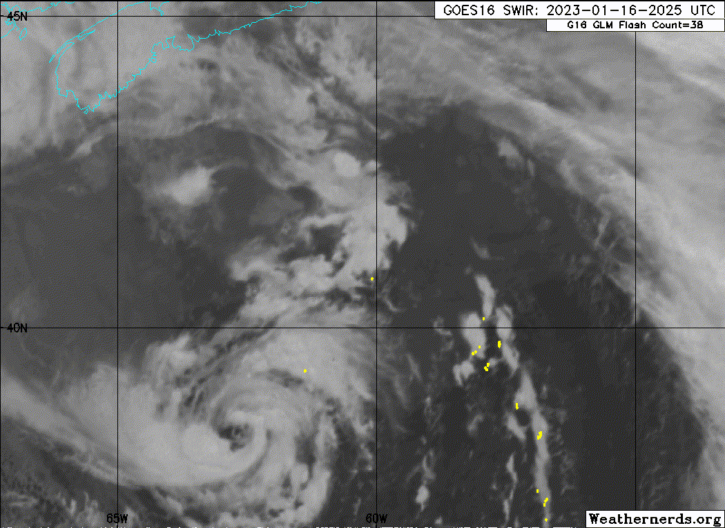
This sure is a beauty for January. I guess the stubborn high over this part of the Atlantic helped warm up SSTs allowing it to exist.
This sure is a beauty for January. I guess the stubborn high over this part of the Atlantic helped warm up SSTs allowing it to exist.
6 likes
Irene '11 Sandy '12 Hermine '16 5/15/2018 Derecho Fay '20 Isaias '20 Elsa '21 Henri '21 Ida '21
I am only a meteorology enthusiast who knows a decent amount about tropical cyclones. Look to the professional mets, the NHC, or your local weather office for the best information.
I am only a meteorology enthusiast who knows a decent amount about tropical cyclones. Look to the professional mets, the NHC, or your local weather office for the best information.
-
Sciencerocks
- Category 5
- Posts: 10181
- Age: 40
- Joined: Thu Jul 06, 2017 1:51 am
Re: ATL: INVEST 90L - Discussion
aspen wrote:It’s kinda ridiculous this only has a 0/0 on the NHC’s site. They’ve really pulled back hard from naming tons of shorties like in 2020/21 and have been super conservative since last season, but as a result have missed several storms that had stronger cases for being classified than stuff like Odette and Teresa (like that 40 kt MDR invest in September). I don’t see why this system with an eyewall and eye isn’t given at least a 50/50 chance.
This sure is a beauty for January. I guess the stubborn high over this part of the Atlantic helped warm up SSTs allowing it to exist.
I doubt they'd even upgrade Alex of 2016 right now. I think it is a reasonable question to ask and I am serious.
That storm developed the same way with a lot of cold air and strato-cu around it and was over cold water...This is every bit as good looking.
3 likes
-
AnnularCane

- S2K Supporter

- Posts: 2957
- Joined: Thu Jun 08, 2006 9:18 am
- Location: Wytheville, VA
Re: ATL: INVEST 90L - Discussion
Sciencerocks wrote:aspen wrote:It’s kinda ridiculous this only has a 0/0 on the NHC’s site. They’ve really pulled back hard from naming tons of shorties like in 2020/21 and have been super conservative since last season, but as a result have missed several storms that had stronger cases for being classified than stuff like Odette and Teresa (like that 40 kt MDR invest in September). I don’t see why this system with an eyewall and eye isn’t given at least a 50/50 chance.
This sure is a beauty for January. I guess the stubborn high over this part of the Atlantic helped warm up SSTs allowing it to exist.
I doubt they'd even upgrade Alex of 2016 right now. I think it is a reasonable question to ask and I am serious.
That storm developed the same way with a lot of cold air and strato-cu around it and was over cold water...This is every bit as good looking.
And Alex was a hurricane... An unnamed TS is one thing but it's hard to imagine an unnamed hurricane in this day and age.
3 likes
"But it never rained rain. It never snowed snow. And it never blew just wind. It rained things like soup and juice. It snowed mashed potatoes and green peas. And sometimes the wind blew in storms of hamburgers." -- Judi Barrett, Cloudy with a Chance of Meatballs
-
Sciencerocks
- Category 5
- Posts: 10181
- Age: 40
- Joined: Thu Jul 06, 2017 1:51 am
Re: ATL: INVEST 90L - Discussion
AnnularCane wrote:Sciencerocks wrote:aspen wrote:It’s kinda ridiculous this only has a 0/0 on the NHC’s site. They’ve really pulled back hard from naming tons of shorties like in 2020/21 and have been super conservative since last season, but as a result have missed several storms that had stronger cases for being classified than stuff like Odette and Teresa (like that 40 kt MDR invest in September). I don’t see why this system with an eyewall and eye isn’t given at least a 50/50 chance.
This sure is a beauty for January. I guess the stubborn high over this part of the Atlantic helped warm up SSTs allowing it to exist.
I doubt they'd even upgrade Alex of 2016 right now. I think it is a reasonable question to ask and I am serious.
That storm developed the same way with a lot of cold air and strato-cu around it and was over cold water...This is every bit as good looking.
And Alex was a hurricane... An unnamed TS is one thing but it's hard to imagine an unnamed hurricane in this day and age.
That microwave image that cycloneye posted suggests that this is also a cane. At least earlier.
6 likes

Re: ATL: INVEST 90L - Discussion
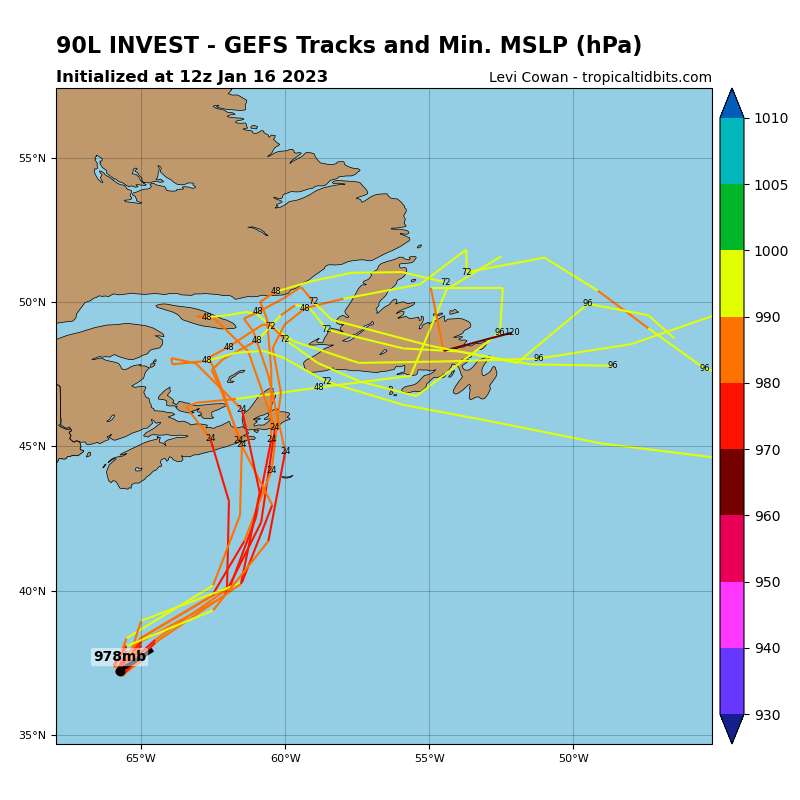
Still LO as of 00z (early best track update?), but up to 55kt/983mb.
AL, 90, 2023011700, , BEST, 0, 399N, 614W, 55, 983, LO,
0 likes
-
cycloneye

- Admin

- Posts: 149275
- Age: 69
- Joined: Thu Oct 10, 2002 10:54 am
- Location: San Juan, Puerto Rico
Re: ATL: INVEST 90L - Discussion
Landy wrote:Still LO as of 00z (early best track update?), but up to 55kt/983mb.AL, 90, 2023011700, , BEST, 0, 399N, 614W, 55, 983, LO,
Another change but don't know if it means anything important. From Invest,S to Invest,M.
AL, 90, 2023011618, , BEST, 0, 378N, 636W, 50, 983, LO, 50, NEQ, 0, 60, 60, 0, 1012, 500, 50, 0, 0, L, 0, , 0, 0, INVEST, S, 0, , 0, 0, 0, 0, genesis-num, 001,
AL, 90, 2023011700, , BEST, 0, 399N, 614W, 55, 983, LO, 34, NEQ, 180, 240, 240, 120, 1012, 500, 50, 0, 0, L, 0, , 0, 0, , 0, , 0, 0, 0, 0, INVEST, M genesis-num, 001,
AL, 90, 2023011700, , BEST, 0, 399N, 614W, 55, 983, LO, 34, NEQ, 180, 240, 240, 120, 1012, 500, 50, 0, 0, L, 0, , 0, 0, , 0, , 0, 0, 0, 0, INVEST, M genesis-num, 001,
0 likes
Visit the Caribbean-Central America Weather Thread where you can find at first post web cams,radars
and observations from Caribbean basin members Click Here
and observations from Caribbean basin members Click Here
-
Hurricane2022
- Category 5
- Posts: 2016
- Joined: Tue Aug 23, 2022 11:38 pm
- Location: Araçatuba, Brazil
Re: ATL: INVEST 90L - Discussion
Landy wrote:Still LO as of 00z (early best track update?), but up to 55kt/983mb.AL, 90, 2023011700, , BEST, 0, 399N, 614W, 55, 983, LO,
I hope they will revise this BT and upgrade 90L to SS Arlene..
1 likes
Sorry for the bad English sometimes...!
For reliable and detailed information for any meteorological phenomenon, please consult the National Hurricane Center, Joint Typhoon Warning Center , or your local Meteo Center.
--------
ECCE OMNIA NOVA FACIAM (Ap 21,5).
For reliable and detailed information for any meteorological phenomenon, please consult the National Hurricane Center, Joint Typhoon Warning Center , or your local Meteo Center.
--------
ECCE OMNIA NOVA FACIAM (Ap 21,5).
Re: ATL: INVEST 90L - Discussion
cycloneye wrote:Landy wrote:Still LO as of 00z (early best track update?), but up to 55kt/983mb.AL, 90, 2023011700, , BEST, 0, 399N, 614W, 55, 983, LO,
Another change but don't know if it means anything important. From Invest,S to Invest,M.AL, 90, 2023011618, , BEST, 0, 378N, 636W, 50, 983, LO, 50, NEQ, 0, 60, 60, 0, 1012, 500, 50, 0, 0, L, 0, , 0, 0, INVEST, S, 0, , 0, 0, 0, 0, genesis-num, 001,
AL, 90, 2023011700, , BEST, 0, 399N, 614W, 55, 983, LO, 34, NEQ, 180, 240, 240, 120, 1012, 500, 50, 0, 0, L, 0, , 0, 0, , 0, , 0, 0, 0, 0, INVEST, M genesis-num, 001,
I did some digging, and it looks like that determines the depth of the system. So now it's medium depth instead of shallow. Found the info here in case I interpreted wrong: https://www.nrlmry.navy.mil/atcf_web/do ... abdeck.txt
3 likes
Re: ATL: INVEST 90L - Discussion
cycloneye wrote:Landy wrote:Still LO as of 00z (early best track update?), but up to 55kt/983mb.AL, 90, 2023011700, , BEST, 0, 399N, 614W, 55, 983, LO,
Another change but don't know if it means anything important. From Invest,S to Invest,M.AL, 90, 2023011618, , BEST, 0, 378N, 636W, 50, 983, LO, 50, NEQ, 0, 60, 60, 0, 1012, 500, 50, 0, 0, L, 0, , 0, 0, INVEST, S, 0, , 0, 0, 0, 0, genesis-num, 001,
AL, 90, 2023011700, , BEST, 0, 399N, 614W, 55, 983, LO, 34, NEQ, 180, 240, 240, 120, 1012, 500, 50, 0, 0, L, 0, , 0, 0, , 0, , 0, 0, 0, 0, INVEST, M genesis-num, 001,
That is the depth of the system, S is shallow, M is medium, D is deep.
3 likes
-
InfernoFlameCat

- Category 5
- Posts: 2127
- Age: 22
- Joined: Mon Dec 14, 2020 10:52 am
- Location: Buford, GA
Re: ATL: INVEST 90L - Discussion
This is not even a shallow warm core then. What do we need to get this thing named?
3 likes
I am by no means a professional. DO NOT look at my forecasts for official information or make decisions based on what I post.
Goal: to become a registered expert over tropical and subtropical cyclones.
Goal: to become a registered expert over tropical and subtropical cyclones.
-
Sciencerocks
- Category 5
- Posts: 10181
- Age: 40
- Joined: Thu Jul 06, 2017 1:51 am
-
Sciencerocks
- Category 5
- Posts: 10181
- Age: 40
- Joined: Thu Jul 06, 2017 1:51 am
Re: ATL: INVEST 90L - Discussion
Sciencerocks wrote:InfernoFlameCat wrote:This is not even a shallow warm core then. What do we need to get this thing named?
I think the prime minister could then direct the Canadian hurricane center to start advisories.
Last edited by Sciencerocks on Mon Jan 16, 2023 8:12 pm, edited 1 time in total.
1 likes
-
PavelGaborik10
- Category 1

- Posts: 472
- Joined: Tue Sep 04, 2018 3:23 pm
Re: ATL: INVEST 90L - Discussion
Whatever is remaining will make "landfall" in my home town tomorrow.
Not expecting anything more than a light impact, those waters are freezing.
Not expecting anything more than a light impact, those waters are freezing.
1 likes
Re: ATL: INVEST 90L - Discussion
Central convection has been deepening, perhaps deeper than it has been for most of the day, as it quickly approaches cooler waters. You would expect it to start deteriorating pretty soon. 
0 likes
Who is online
Users browsing this forum: No registered users and 21 guests