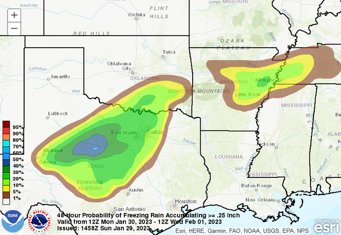
txtwister78 wrote:The "good thing" so far is based on the latest HRRR/NAM, not seeing temps inside the major cities drop below 30 degrees for long (AUS/SA get to 30-32 in western/northern areas). DFW for now doesn't drop below 30 degrees in long duration (perhaps a few hours).
Temps will probably hover and even rise a few degrees as mentioned yesterday as the precip picks up from the south and so for hopefully this stays more bridges/overpasses up in DFW (which can still be a big problem for obvious reasons) but right now I don't see this becoming a major ice event for the surface roads/sidewalks etc with temps being what they're forecasted to be thus far along with soil temps being warm out ahead of this. Hill Country (Areas north & west of SA/Aus) and areas to the west of the Metroplex could experience more widespread difficulties I think where the surface temps will stay in the mid to upper 20's for a much longer period.
Tuesday night into early Wed morning is probably going to end up being the "main event" with this setup for most locations.
I’m with you here and this really matches my thinking as well. Now, I’m basing my thinking on the NAM being worst case scenario as it relates to temperatures here in Travis County. If the NAM is too warm then all bets are off, because we will have enough qpf down here to create havoc if it freezes on the surface.
 The posts in this forum are NOT official forecast and should not be used as such. They are just the opinion of the poster and may or may not be backed by sound meteorological data. They are NOT endorsed by any professional institution or


