
SIO: FREDDY - Remnants
Moderator: S2k Moderators
-
cycloneye

- Admin

- Posts: 149275
- Age: 69
- Joined: Thu Oct 10, 2002 10:54 am
- Location: San Juan, Puerto Rico
Re: SIO: FREDDY - Intense Tropical Cyclone
Making another run to cat 5.
0 likes
Visit the Caribbean-Central America Weather Thread where you can find at first post web cams,radars
and observations from Caribbean basin members Click Here
and observations from Caribbean basin members Click Here
Re: SIO: FREDDY - Intense Tropical Cyclone
Once Freddy is finally done, the S Indian ocean season will possibly have close to normal ACE even if nothing formed for the rest of the season.
0 likes
-
cycloneye
- Admin
- Posts: 149275
- Age: 69
- Joined: Thu Oct 10, 2002 10:54 am
- Location: San Juan, Puerto Rico
Re: SIO: FREDDY - Intense Tropical Cyclone
0 likes
Visit the Caribbean-Central America Weather Thread where you can find at first post web cams,radars
and observations from Caribbean basin members Click Here
and observations from Caribbean basin members Click Here
-
cycloneye
- Admin
- Posts: 149275
- Age: 69
- Joined: Thu Oct 10, 2002 10:54 am
- Location: San Juan, Puerto Rico
Re: SIO: FREDDY - Very Intense Tropical Cyclone
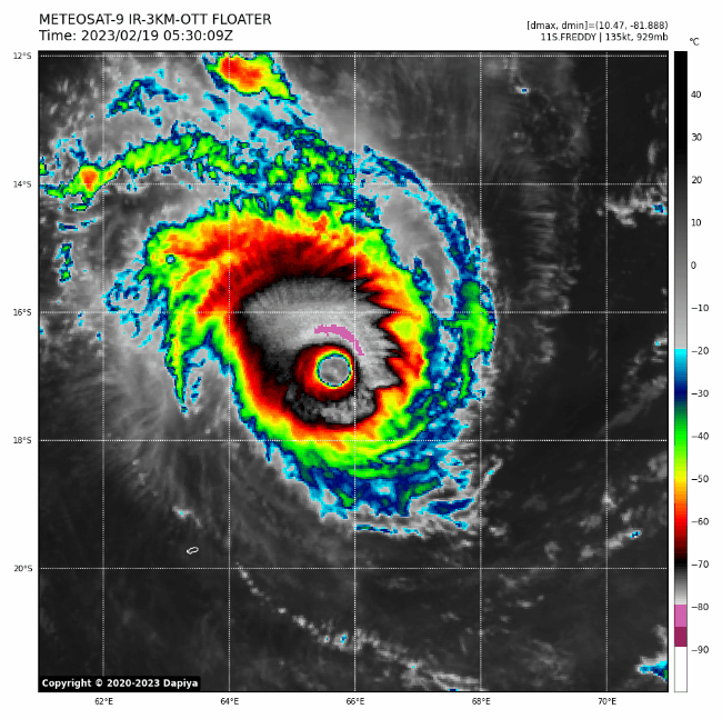
Breaking News=Meteo-France upgrades to Very Intense Tropical Cyclone. JTWC goes up to 155 mph. 11S FREDDY 230219 0000 16.7S 67.0E SHEM 135 929
VERY INTENSE TROPICAL CYCLONE number 7
(FREDDY)
Maximum winds (averaged over 10 minutes) estimated at sea: 220 km/h.
Estimated maximum gusts at sea: 315 km/h.
Estimated pressure at the center: 931 hPa.
Position on February 19 at 04 local time: 16.7 South / 67.0 East.
Distance from the coast of Reunion: 1275 km to the sector: EAST-NORTH-EAST
Distance from Mayotte: 2390 km to the sector: EAST-SOUTH-EAST
Movement: WEST-SOUTH-WEST, at 22 km/h.
0 likes
Visit the Caribbean-Central America Weather Thread where you can find at first post web cams,radars
and observations from Caribbean basin members Click Here
and observations from Caribbean basin members Click Here
-
ElectricStorm

- Category 5

- Posts: 5140
- Age: 25
- Joined: Tue Aug 13, 2019 11:23 pm
- Location: Norman, OK
Re: SIO: FREDDY - Very Intense Tropical Cyclone
Welp, never really thought this would be one to become a serious land threat but here we are... Hopefully it's not to bad but it's looking nasty
0 likes
B.S Meteorology, University of Oklahoma '25
Please refer to the NHC, NWS, or SPC for official information.
Please refer to the NHC, NWS, or SPC for official information.
-
Iceresistance

- Category 5
- Posts: 9579
- Age: 22
- Joined: Sat Oct 10, 2020 9:45 am
- Location: Tecumseh, OK/Norman, OK
Re: SIO: FREDDY - Very Intense Tropical Cyclone
ElectricStorm wrote:Welp, never really thought this would be one to become a serious land threat but here we are... Hopefully it's not to bad but it's looking nasty
Cyclone Leon-Eline did the same thing in 2000.
0 likes
Bill 2015 & Beta 2020
Winter 2020-2021
All observations are in Tecumseh, OK unless otherwise noted.
Winter posts are focused mainly for Oklahoma & Texas.
Take any of my forecasts with a grain of salt, refer to the NWS, SPC, and NHC for official information
Never say Never with weather! Because ANYTHING is possible!
Winter 2020-2021
All observations are in Tecumseh, OK unless otherwise noted.
Winter posts are focused mainly for Oklahoma & Texas.
Take any of my forecasts with a grain of salt, refer to the NWS, SPC, and NHC for official information
Never say Never with weather! Because ANYTHING is possible!
-
cycloneye
- Admin
- Posts: 149275
- Age: 69
- Joined: Thu Oct 10, 2002 10:54 am
- Location: San Juan, Puerto Rico
Re: SIO: FREDDY - Very Intense Tropical Cyclone
JTWC forecasts cat 5 for 12z on Sunday and after that, begins to weaken slowly.

0 likes
Visit the Caribbean-Central America Weather Thread where you can find at first post web cams,radars
and observations from Caribbean basin members Click Here
and observations from Caribbean basin members Click Here
-
Meow

- Tropical Depression

- Posts: 66
- Age: 36
- Joined: Mon Aug 03, 2020 9:03 am
- Location: New Taipei, Taiwan
- Contact:
Re: SIO: FREDDY - Very Intense Tropical Cyclone
Iceresistance wrote:ElectricStorm wrote:Welp, never really thought this would be one to become a serious land threat but here we are... Hopefully it's not to bad but it's looking nasty
Cyclone Leon-Eline did the same thing in 2000.
Freddy is much stronger than Eline.
0 likes
Wikimedia User:Meow
-
Yellow Evan

- Professional-Met

- Posts: 16231
- Age: 27
- Joined: Fri Jul 15, 2011 12:48 pm
- Location: Henderson, Nevada/Honolulu, HI
- Contact:
Re: SIO: FREDDY - Very Intense Tropical Cyclone
Dealing with southeasterly shear that is preventing further organization.
0 likes
-
Hurricane2022

- Category 5
- Posts: 2016
- Joined: Tue Aug 23, 2022 11:38 pm
- Location: Araçatuba, Brazil
Re: SIO: FREDDY - Very Intense Tropical Cyclone
0 likes
Sorry for the bad English sometimes...!
For reliable and detailed information for any meteorological phenomenon, please consult the National Hurricane Center, Joint Typhoon Warning Center , or your local Meteo Center.
--------
ECCE OMNIA NOVA FACIAM (Ap 21,5).
For reliable and detailed information for any meteorological phenomenon, please consult the National Hurricane Center, Joint Typhoon Warning Center , or your local Meteo Center.
--------
ECCE OMNIA NOVA FACIAM (Ap 21,5).
-
Hurricane2022
- Category 5
- Posts: 2016
- Joined: Tue Aug 23, 2022 11:38 pm
- Location: Araçatuba, Brazil
Re: SIO: FREDDY - Very Intense Tropical Cyclone
...Freddy is a powerful and robust Category 5 tropical cyclone. It also looks like it will soon become 100% annular.
I believe it has a good chance of reaching winds of up to 150 kt today.


I believe it has a good chance of reaching winds of up to 150 kt today.
2 likes
Sorry for the bad English sometimes...!
For reliable and detailed information for any meteorological phenomenon, please consult the National Hurricane Center, Joint Typhoon Warning Center , or your local Meteo Center.
--------
ECCE OMNIA NOVA FACIAM (Ap 21,5).
For reliable and detailed information for any meteorological phenomenon, please consult the National Hurricane Center, Joint Typhoon Warning Center , or your local Meteo Center.
--------
ECCE OMNIA NOVA FACIAM (Ap 21,5).
-
cycloneye
- Admin
- Posts: 149275
- Age: 69
- Joined: Thu Oct 10, 2002 10:54 am
- Location: San Juan, Puerto Rico
Re: SIO: FREDDY - Very Intense Tropical Cyclone
VERY INTENSE TROPICAL CYCLONE number 7
(FREDDY)
Maximum winds (averaged over 10 minutes) estimated at sea: 220 km/h.
Estimated maximum gusts at sea: 315 km/h.
Estimated pressure at the center: 931 hPa.
Position on February 19 at 10 a.m. local time: 16.9 South / 65.6 East.
Distance from the coast of Reunion: 1125 km to the sector: EAST-NORTH-EAST
Distance from Mayotte: 2240 km to the sector: EAST-SOUTH-EAST
Movement: WEST, at 24 km/h.
0 likes
Visit the Caribbean-Central America Weather Thread where you can find at first post web cams,radars
and observations from Caribbean basin members Click Here
and observations from Caribbean basin members Click Here
-
Hurricane2022
- Category 5
- Posts: 2016
- Joined: Tue Aug 23, 2022 11:38 pm
- Location: Araçatuba, Brazil
Re: SIO: FREDDY - Very Intense Tropical Cyclone
Back to Category 4 (???)

11S FREDDY 230219 1200 17.4S 64.1E SHEM 130 934
0 likes
Sorry for the bad English sometimes...!
For reliable and detailed information for any meteorological phenomenon, please consult the National Hurricane Center, Joint Typhoon Warning Center , or your local Meteo Center.
--------
ECCE OMNIA NOVA FACIAM (Ap 21,5).
For reliable and detailed information for any meteorological phenomenon, please consult the National Hurricane Center, Joint Typhoon Warning Center , or your local Meteo Center.
--------
ECCE OMNIA NOVA FACIAM (Ap 21,5).
-
Iceresistance
- Category 5
- Posts: 9579
- Age: 22
- Joined: Sat Oct 10, 2020 9:45 am
- Location: Tecumseh, OK/Norman, OK
Re: SIO: FREDDY - Very Intense Tropical Cyclone
Meow wrote:Iceresistance wrote:ElectricStorm wrote:Welp, never really thought this would be one to become a serious land threat but here we are... Hopefully it's not to bad but it's looking nasty
Cyclone Leon-Eline did the same thing in 2000.
Freddy is much stronger than Eline.
Well, yes, but the only proper analog for a Tropical Cyclone that has remained mostly intact from the Australia region all the way to Madagascar and Africa is Leon-Eline.
0 likes
Bill 2015 & Beta 2020
Winter 2020-2021
All observations are in Tecumseh, OK unless otherwise noted.
Winter posts are focused mainly for Oklahoma & Texas.
Take any of my forecasts with a grain of salt, refer to the NWS, SPC, and NHC for official information
Never say Never with weather! Because ANYTHING is possible!
Winter 2020-2021
All observations are in Tecumseh, OK unless otherwise noted.
Winter posts are focused mainly for Oklahoma & Texas.
Take any of my forecasts with a grain of salt, refer to the NWS, SPC, and NHC for official information
Never say Never with weather! Because ANYTHING is possible!

Re: SIO: FREDDY - Very Intense Tropical Cyclone
Hurricane2022 wrote:Back to Category 4 (???)11S FREDDY 230219 1200 17.4S 64.1E SHEM 130 934
https://imageshack.com/i/pnTHGuKKp
I honestly don't see how that downgrade even makes sense:
0 likes
TC naming lists: retirements and intensity
Most aggressive Advisory #1's in North Atlantic (cr. kevin for starting the list)
Most aggressive Advisory #1's in North Atlantic (cr. kevin for starting the list)
-
MarioProtVI
- Category 5
- Posts: 1034
- Age: 24
- Joined: Sun Sep 29, 2019 7:33 pm
- Location: New Jersey
Re: SIO: FREDDY - Very Intense Tropical Cyclone
This thing really is the SHEM’s equivalent of Irma, with the very long track, ACE machine, fluctuating intensity especially at the start and two separate C5 peaks. Insane.
0 likes
-
cycloneye
- Admin
- Posts: 149275
- Age: 69
- Joined: Thu Oct 10, 2002 10:54 am
- Location: San Juan, Puerto Rico
Re: SIO: FREDDY - Very Intense Tropical Cyclone
0 likes
Visit the Caribbean-Central America Weather Thread where you can find at first post web cams,radars
and observations from Caribbean basin members Click Here
and observations from Caribbean basin members Click Here
-
cycloneye
- Admin
- Posts: 149275
- Age: 69
- Joined: Thu Oct 10, 2002 10:54 am
- Location: San Juan, Puerto Rico
Re: SIO: FREDDY - Very Intense Tropical Cyclone
Bulletin of February 19 at 7:08 p.m. local in Reunion (6:08 p.m. local in Mayotte):
VERY INTENSE TROPICAL CYCLONE FREDDY
Maximum winds (averaged over 10 minutes) estimated at sea: 220 km/h.
Estimated maximum gusts at sea: 315 km/h.
Estimated pressure at the center: 931 hPa.
Position on February 19 at 7 p.m. local Reunion: 17.5 South / 63.2 East.
Distance from the coast of Reunion: 875 km to the EAST-NORTH-EAST sector
Distance from Mayotte: 2010 km to the EAST-SOUTH-EAST sector
Movement: WEST-SOUTH-WEST, at 26 km/h.
0 likes
Visit the Caribbean-Central America Weather Thread where you can find at first post web cams,radars
and observations from Caribbean basin members Click Here
and observations from Caribbean basin members Click Here
-
cycloneye
- Admin
- Posts: 149275
- Age: 69
- Joined: Thu Oct 10, 2002 10:54 am
- Location: San Juan, Puerto Rico
Re: SIO: FREDDY - Very Intense Tropical Cyclone
Continues very impressive.

0 likes
Visit the Caribbean-Central America Weather Thread where you can find at first post web cams,radars
and observations from Caribbean basin members Click Here
and observations from Caribbean basin members Click Here
-
cycloneye
- Admin
- Posts: 149275
- Age: 69
- Joined: Thu Oct 10, 2002 10:54 am
- Location: San Juan, Puerto Rico
Re: SIO: FREDDY - Very Intense Tropical Cyclone
TXXS26 KNES 191829
TCSSIO
CCA
A. 11S (FREDDY)
B. 19/1730Z
C. 17.6S
D. 62.5E
E. ONE/MET-9
F. T6.5/6.5
G. IR/EIR/SWIR
H. REMARKS...COR FOR TYPO. LARGE STADIUM-EFFECT WMG EYE SURROUNDED
BY W AND EMBEDDED IN B RESULTS IN AN E# OF 5.5 WITH EADJ +1.0 FOR
A DT OF 6.5. OUTSTANDING SATELLITE PRESENTATION. ANNULAR STRUCTURE
CONTINUES. POLEWARD AND EQUATORIAL UPR-LVL OUTFLOW CHANNELS BECMG MORE
DEFINED. EYE TEMP +20 C. MET=6.5 AND PT=7.0. FT BASED ON DT.
I. ADDL POSITIONS
NIL
...KONON
0 likes
Visit the Caribbean-Central America Weather Thread where you can find at first post web cams,radars
and observations from Caribbean basin members Click Here
and observations from Caribbean basin members Click Here
Who is online
Users browsing this forum: No registered users and 55 guests