Texas Spring 2023
Moderator: S2k Moderators
Forum rules

The posts in this forum are NOT official forecast and should not be used as such. They are just the opinion of the poster and may or may not be backed by sound meteorological data. They are NOT endorsed by any professional institution or STORM2K.
-
Texas Snowman

- Storm2k Moderator

- Posts: 6197
- Joined: Fri Jan 25, 2008 11:29 am
- Location: Denison, Texas
Texas Spring 2023
A new meteorological season is approaching here in Texas. Hopefully not too much severe weather, but a good amount of beneficial rain. And maybe even a late winter surprise or two…
2 likes
The above post and any post by Texas Snowman is NOT an official forecast and should not be used as such. It is just the opinion of the poster and may or may not be backed by sound meteorological data. It is NOT endorsed by any professional institution including storm2k.org. For official information, please refer to NWS products.

Re: Texas Spring 2023
Winter disappointed me in Longview, but my favorite time of year is quickly approaching... Spring! I'm a severe weather enthusiast so bring on the spring storms!
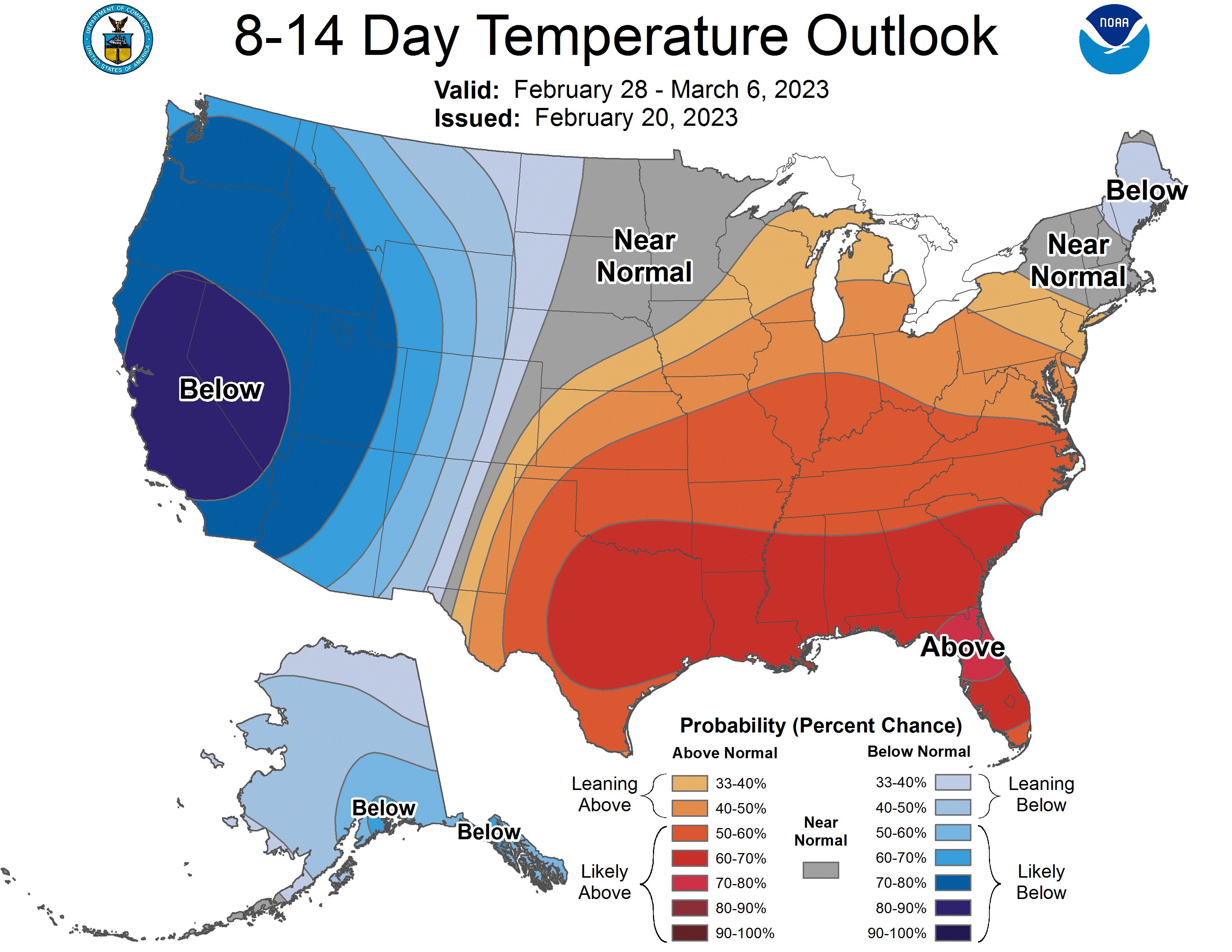
March temperatures look above average... hopefully we don't see an early summer and can enjoy spring for a few months.
March temperatures look above average... hopefully we don't see an early summer and can enjoy spring for a few months.
1 likes
-
bubba hotep

- S2K Supporter

- Posts: 6014
- Joined: Wed Dec 28, 2016 1:00 am
- Location: Collin County Texas
Re: Texas Spring 2023
Hopefully, this Spring brings better rain chances for South Central and Southeast TX with the La Nina slowly losing its grip as the year progresses (I'm not nearly as concerned with rain chances in North and NW TX). As a result, the SOI should hopefully trend consistently near 0 and eventually trend consistently negative due to more WWB (Westerly Wind Bursts) in the Nino 3.4 as compared to the strong EWB (Easterly Wind Bursts) of the past few years. The SOI hasn't been consistently near 0 since May 1, 2020 (2.57) and consistently negative since December 1, 2019 (-6.72). https://www.longpaddock.qld.gov.au/soi/monthly-graphs/
More importantly, if long-range forecasts are to be believed, a Neutral ENSO trending toward El Nino later this year should lead to a more Positive PDO-looking orientation in the Pacific as compared to the well-defined Negative PDO orientation of the past few years. Though we still may officially be in a Negative or Cool Phase of the PDO, we can still get positive spikes or Warm-looking Phases of the PDO which would theoretically lead to overall better rain chances over Texas and the Southern Plains in conjunction with a more active southern jet stream. A 'Super El Nino', as some have been predicting to develop later this year, may help our cause in trending the PDO warmer even if temporarily for a year or so. I'm kinda hoping this recent anomalous cool 3-year La Nina serves as the peak of this current Negative or Cool Phase PDO we have been experiencing since around 2008 or so and we eventually trend to an official Positive or Warm Phase PDO again in a few years.
All in all, I'm hopeful for a more promising long-range weather pattern with more consistent rainfall accumulations for our regions despite these trends not showing up in short or medium-forecast modeling as of this time. We shall see what not only Spring but also Summer and Fall bring as a result of these forecasted ENSO changes later this year.
3 likes
-
South Texas Storms

- Professional-Met

- Posts: 4256
- Joined: Thu Jun 24, 2010 12:28 am
- Location: Houston, TX
Re: Texas Spring 2023
869MB wrote:Hopefully, this Spring brings better rain chances for South Central and Southeast TX with the La Nina slowly losing its grip as the year progresses (I'm not nearly as concerned with rain chances in North and NW TX). As a result, the SOI should hopefully trend consistently near 0 and eventually trend consistently negative due to more WWB (Westerly Wind Bursts) in the Nino 3.4 as compared to the strong EWB (Easterly Wind Bursts) of the past few years. The SOI hasn't been consistently near 0 since May 1, 2020 (2.57) and consistently negative since December 1, 2019 (-6.72). https://www.longpaddock.qld.gov.au/soi/monthly-graphs/
More importantly, if long-range forecasts are to be believed, a Neutral ENSO trending toward El Nino later this year should lead to a more Positive PDO-looking orientation in the Pacific as compared to the well-defined Negative PDO orientation of the past few years. Though we still may officially be in a Negative or Cool Phase of the PDO, we can still get positive spikes or Warm-looking Phases of the PDO which would theoretically lead to overall better rain chances over Texas and the Southern Plains in conjunction with a more active southern jet stream. A 'Super El Nino', as some have been predicting to develop later this year, may help our cause in trending the PDO warmer even if temporarily for a year or so. I'm kinda hoping this recent anomalous cool 3-year La Nina serves as the peak of this current Negative or Cool Phase PDO we have been experiencing since around 2008 or so and we eventually trend to an official Positive or Warm Phase PDO again in a few years.
All in all, I'm hopeful for a more promising long-range weather pattern with more consistent rainfall accumulations for our regions despite these trends not showing up in short or medium-forecast modeling as of this time. We shall see what not only Spring but also Summer and Fall bring as a result of these forecasted ENSO changes later this year.
Yeah I'm optimistic we'll trend wetter as we head through the year with El Nino likely returning. It sure would be nice for the state to be drought free again as we head into 2024!
2 likes
-
cycloneye

- Admin

- Posts: 149366
- Age: 69
- Joined: Thu Oct 10, 2002 10:54 am
- Location: San Juan, Puerto Rico
Re: Texas Spring 2023
Here is the latest drought map of the state that is updated every thursdays with the stats.


https://droughtmonitor.unl.edu/CurrentM ... or.aspx?TX
https://droughtmonitor.unl.edu/CurrentM ... or.aspx?TX
0 likes
Visit the Caribbean-Central America Weather Thread where you can find at first post web cams,radars
and observations from Caribbean basin members Click Here
and observations from Caribbean basin members Click Here
-
bubba hotep
- S2K Supporter
- Posts: 6014
- Joined: Wed Dec 28, 2016 1:00 am
- Location: Collin County Texas
Re: Texas Spring 2023
cycloneye wrote:Here is the latest drought map of the state that is updated every thursdays with the stats.
https://i.imgur.com/jLRnlzE.jpg
https://i.imgur.com/gaScwuE.jpg
https://droughtmonitor.unl.edu/CurrentM ... or.aspx?TX
It's crazy how persistent that small area of exceptional drought has been in South Central Texas.
0 likes
Winter time post are almost exclusively focused on the DFW area.
-
bubba hotep
- S2K Supporter
- Posts: 6014
- Joined: Wed Dec 28, 2016 1:00 am
- Location: Collin County Texas

Re: Texas Spring 2023
bubba hotep wrote:https://pbs.twimg.com/media/Fpw5EVtaEAA4I8N?format=jpg&name=medium
We’ll see about that.
0 likes
-
Brent
- S2K Supporter
- Posts: 38737
- Age: 37
- Joined: Sun May 16, 2004 10:30 pm
- Location: Tulsa Oklahoma
- Contact:
Re: Texas Spring 2023
Apps are definitely on the cold side for March and I will say they were way too warm the last couple days a week or so ago  we shall see but I'll be shocked if we don't at least see a snowstorm threat here. The last couple days have proved that winter definitely isn't over
Lol right as I said that the 0z GFS has some snow into North Texas early Friday 
Lol right as I said that the 0z GFS has some snow into North Texas early Friday
1 likes
#neversummer
-
bubba hotep
- S2K Supporter
- Posts: 6014
- Joined: Wed Dec 28, 2016 1:00 am
- Location: Collin County Texas
Re: Texas Spring 2023
Cpv17 wrote:bubba hotep wrote:https://pbs.twimg.com/media/Fpw5EVtaEAA4I8N?format=jpg&name=medium
We’ll see about that.
There is broad support for it and we will probably see it trend colder. Longest below normal stretch of winter will be in March lol
3 likes
Winter time post are almost exclusively focused on the DFW area.
-
bubba hotep
- S2K Supporter
- Posts: 6014
- Joined: Wed Dec 28, 2016 1:00 am
- Location: Collin County Texas
Re: Texas Spring 2023
Who ordered up this Spring weather?

3 likes
Winter time post are almost exclusively focused on the DFW area.
-
Brent
- S2K Supporter
- Posts: 38737
- Age: 37
- Joined: Sun May 16, 2004 10:30 pm
- Location: Tulsa Oklahoma
- Contact:
Re: Texas Spring 2023
Yeah our TV met just mentioned it too
It's a shame we wasted February but we're not dead up here yet for sure although I might laugh if our best snowstorm is in March
0 likes
#neversummer
Re: Texas Spring 2023
Brent wrote:
Yeah our TV met just mentioned it too
It's a shame we wasted February but we're not dead up here yet for sure although I might laugh if our best snowstorm is in March
Hell as far north as you live, it can probably still snow there in April lol
0 likes
-
Brent
- S2K Supporter
- Posts: 38737
- Age: 37
- Joined: Sun May 16, 2004 10:30 pm
- Location: Tulsa Oklahoma
- Contact:
Re: Texas Spring 2023
Cpv17 wrote:Brent wrote:
Yeah our TV met just mentioned it too
It's a shame we wasted February but we're not dead up here yet for sure although I might laugh if our best snowstorm is in March
Hell as far north as you live, it can probably still snow there in April lol
Haha it's actually snowed in May before
It's just weird that February would come up with nothing. I mean I haven't even seen a flake this month
0 likes
#neversummer
-
txtwister78

- Category 5

- Posts: 2175
- Joined: Wed Jan 30, 2019 12:56 pm
- Location: San Antonio
Re: Texas Spring 2023
Concerned about the potential for another severe weather outbreak on Thursday focused further south into parts of Texas this time. Models look to be trending slower today with the approaching system/trough ejecting out from the west on Thursday. Ample shear (NAM parameters/soundings 84 hours out look insane already) along with the classic spring clash of airmasses across the state likely to be in place. Obviously other factors need to be considered as we get closer, but definitely something to keep an eye on going forward this week.
0 likes
-
cheezyWXguy

- Category 5
- Posts: 6282
- Joined: Mon Feb 13, 2006 12:29 am
- Location: Dallas, TX
Re: Texas Spring 2023
txtwister78 wrote:Concerned about the potential for another severe weather outbreak on Thursday focused further south into parts of Texas this time. Models look to be trending slower today with the approaching system/trough ejecting out from the west on Thursday. Ample shear (NAM parameters/soundings 84 hours out look insane already) along with the classic spring clash of airmasses across the state likely to be in place. Obviously other factors need to be considered as we get closer, but definitely something to keep an eye on going forward this week.
Agreed, my eyes have been glued to this since the SPC started highlighting it. If the nam timing is right, most of central and eastern Texas will be in the thick of this, along with points east of course
0 likes
-
Iceresistance

- Category 5
- Posts: 9581
- Age: 22
- Joined: Sat Oct 10, 2020 9:45 am
- Location: Tecumseh, OK/Norman, OK
Re: Texas Spring 2023
cheezyWXguy wrote:txtwister78 wrote:Concerned about the potential for another severe weather outbreak on Thursday focused further south into parts of Texas this time. Models look to be trending slower today with the approaching system/trough ejecting out from the west on Thursday. Ample shear (NAM parameters/soundings 84 hours out look insane already) along with the classic spring clash of airmasses across the state likely to be in place. Obviously other factors need to be considered as we get closer, but definitely something to keep an eye on going forward this week.
Agreed, my eyes have been glued to this since the SPC started highlighting it. If the nam timing is right, most of central and eastern Texas will be in the thick of this, along with points east of course
The 12z NAM timing also has me under this, it tries to have Last Night for me all over again!
0 likes
Bill 2015 & Beta 2020
Winter 2020-2021
All observations are in Tecumseh, OK unless otherwise noted.
Winter posts are focused mainly for Oklahoma & Texas.
Take any of my forecasts with a grain of salt, refer to the NWS, SPC, and NHC for official information
Never say Never with weather! Because ANYTHING is possible!
Winter 2020-2021
All observations are in Tecumseh, OK unless otherwise noted.
Winter posts are focused mainly for Oklahoma & Texas.
Take any of my forecasts with a grain of salt, refer to the NWS, SPC, and NHC for official information
Never say Never with weather! Because ANYTHING is possible!
-
cheezyWXguy
- Category 5
- Posts: 6282
- Joined: Mon Feb 13, 2006 12:29 am
- Location: Dallas, TX
Re: Texas Spring 2023
Iceresistance wrote:cheezyWXguy wrote:txtwister78 wrote:Concerned about the potential for another severe weather outbreak on Thursday focused further south into parts of Texas this time. Models look to be trending slower today with the approaching system/trough ejecting out from the west on Thursday. Ample shear (NAM parameters/soundings 84 hours out look insane already) along with the classic spring clash of airmasses across the state likely to be in place. Obviously other factors need to be considered as we get closer, but definitely something to keep an eye on going forward this week.
Agreed, my eyes have been glued to this since the SPC started highlighting it. If the nam timing is right, most of central and eastern Texas will be in the thick of this, along with points east of course
The 12z NAM timing also has me under this, it tries to have Last Night for me all over again!
As of right now it’s definitely an outlier with regard to timing. We’ll need at least another of day of runs to start piecing together trends though, as we’re basically still out in the nam’s la-la land
0 likes
Return to “USA & Caribbean Weather”
Who is online
Users browsing this forum: AnnularCane and 49 guests