
90P INVEST 230312 1200 14.0S 170.0E SHEM 15 0
SPAC: INVEST 90P
Moderator: S2k Moderators
-
cycloneye

- Admin

- Posts: 149845
- Age: 69
- Joined: Thu Oct 10, 2002 10:54 am
- Location: San Juan, Puerto Rico
Re: SPAC: INVEST 90P
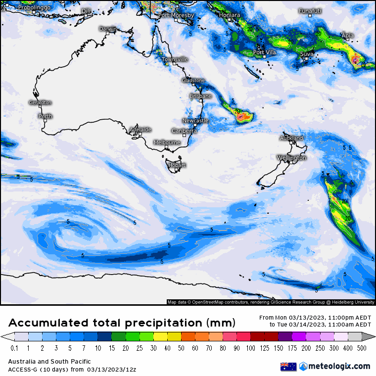
AN AREA OF CONVECTION (INVEST 90P) HAS PERSISTED NEAR 14.6S
169.2E, APPROXIMATELY 196 NM NORTH-NORTHEAST OF PORT VILA, VANUATU.
ANIMATED ENHANCED INFRARED SATELLITE IMAGERY DEPICTS PERSISTENT DEEP
CONVECTION ALONG THE SOUTHERN SEMICIRCLE OF A BROAD LOW-LEVEL
CIRCULATION CENTER (LLCC). A 121438Z AMSR2 36GHZ MICROWAVE IMAGE
REVEALS FORMATIVE, FRAGMENTED BANDING WRAPPING INTO AN ELONGATED BUT
DEFINED LLCC. THE SYSTEM IS LOCATED ALONG THE NORTHERN PERIPHERY OF AN
UPPER-LEVEL ANTICYCLONE WITHIN A MARGINALLY FAVORABLE ENVIRONMENT
CHARACTERIZED BY LOW TO MODERATE (15 TO 20 KNOTS) EASTERLY VERTICAL
WIND SHEAR AND BROAD DIFFLUENCE ALOFT. SST VALUES ARE CONDUCIVE AT
29C, HOWEVER, FRICTIONAL EFFECTS ASSOCIATED WITH VANUATU WILL HINDER
SIGNIFICANT DEVELOPMENT. GLOBAL MODELS INDICATE A SLOW, ERRATIC
SOUTHWARD TO SOUTHWESTWARD TRACK OVER THE NEXT TWO DAYS WITH GRADUAL
DEVELOPMENT. MAXIMUM SUSTAINED SURFACE WINDS ARE ESTIMATED AT 15 TO 20
KNOTS. MINIMUM SEA LEVEL PRESSURE IS ESTIMATED TO BE NEAR 1006 MB. THE
POTENTIAL FOR THE DEVELOPMENT OF A SIGNIFICANT TROPICAL CYCLONE WITHIN
THE NEXT 24 HOURS IS LOW.
0 likes
Visit the Caribbean-Central America Weather Thread where you can find at first post web cams,radars
and observations from Caribbean basin members Click Here
and observations from Caribbean basin members Click Here
-
wxman57

- Moderator-Pro Met

- Posts: 23178
- Age: 68
- Joined: Sat Jun 21, 2003 8:06 pm
- Location: Houston, TX (southwest)
Re: SPAC: INVEST 90P
This will likely be the next named storm. Best chance of development in any basin.
0 likes

Re: SPAC: INVEST 90P
On paper atm looks a heavy precip threat for New Caledonia. Then rides a ridge nw in the coral sea intensifying. Be watching this one closley myself for realtime verification later in its track.
0 likes
-
Iceresistance

- Category 5

- Posts: 9610
- Age: 22
- Joined: Sat Oct 10, 2020 9:45 am
- Location: Tecumseh, OK/Norman, OK
Re: SPAC: INVEST 90P
Cycles wrote:On paper atm looks a heavy precip threat for New Caledonia. Then rides a ridge nw in the coral sea intensifying. Be watching this one closley myself for realtime verification later in its track.
https://i.postimg.cc/SKsvkSLt/modaus-20230314-0000-animation.gif
Welcome to the Team!
0 likes
Bill 2015 & Beta 2020
Winter 2020-2021
All observations are in Tecumseh, OK unless otherwise noted.
Winter posts are focused mainly for Oklahoma & Texas.
Take any of my forecasts with a grain of salt, refer to the NWS, SPC, and NHC for official information
Never say Never with weather! Because ANYTHING is possible!
Winter 2020-2021
All observations are in Tecumseh, OK unless otherwise noted.
Winter posts are focused mainly for Oklahoma & Texas.
Take any of my forecasts with a grain of salt, refer to the NWS, SPC, and NHC for official information
Never say Never with weather! Because ANYTHING is possible!
Re: SPAC: INVEST 90P
Logo Meteo France
Vigilance follow-up bulletin
Number: 29
Issued: Thursday, March 16, 2023 at 5:57 a.m.
Date and time of the next bulletin: Thursday, March 16, 2023 at 12:00 p.m.
All times mentioned are local times.
Type of event: Heavy rain/thunderstorms
Start of event: Ongoing
End of event scheduled for: Friday, March 17, 2023 at 06:00 at least
Orange Alert:
- Heavy rains/thunderstorms in the municipalities of Lifou, Maré, Mont-Dore, Yaté, Dumbéa, Nouméa, Païta, Thio, Boulouparis, Canala, Kouaoua, Houaïlou.
Yellow Vigilance:
- Heavy rains/thunderstorms in the municipalities of Bélep, Poum, Ouégoa, Pouébo, Pouembout, Ponérihouen, Poindimié, Koné, Voh, Hienghène, Touho, Kaala-Gomen, Koumac, Ouvéa, Ile des Pins, La Foa, Sarraméa, Moindou, Farino, Bourail, Poya.
Current situation
Establishment of an active storm episode, as it occurs once or twice a year, and requiring special monitoring.
New Caledonia is under the influence of a depression at 1006 hPa centered about 250 km northwest of Bélep on the one hand, and a powerful anticyclone centered on New Zealand on the other.
A cloud cluster continues to organize around the center of the depression north of New Caledonia.
The stormy axis which activated towards Lifou and Maré yesterday has gradually stretched towards the south of Grande Terre in recent hours. At 5 a.m. local time, the total rainfall in 12 hours reached 217 mm in Rivière blanche, 165 mm in Montagne des sources, 164 mm in Borindi, 106 mm in Dumbéa, 95 mm in Thio, 91 mm in Nakutakoin, 69 mm in Poindimié , 70 mm at La Coulée, 49 mm at Magenta, locally 40 to 50 mm at Maré and Lifou and 60 mm at Bélep.
Planned development
The depression at the origin of this situation remains not very intense: according to the most probable scenario, it is not expected to reach the stage of moderate tropical depression. Due to the powerful anticyclone which is blocking south of New Caledonia, this depression is not very mobile and initially remains centered northwest of Bélep before slowly shifting towards New Caledonia during the day.
In this situation of blockage and flow from North to North-East humid and unstable, the stormy axis is maintained between the south of Loyalty and the south of Grande Terre for at least 24 hours.
As a result, for the next 24 hours:
Vigilance orange Heavy Rain / Thunderstorms in the south of Grande Terre, Lifou and Maré: rainfall is heavy and stormy on Thursday and the following night.
Cumulative precipitation reaches 150 to 200 mm or even locally 200-250 mm in 24 hours, particularly on the eastern slopes of the chain, but rain and storm cells also reach the western slopes and the level of rivers can rise by either side of the chain. Lightning strikes are possible. Wind gusts at around 35 kt are also expected.
Yellow Vigilance Heavy Rains / Thunderstorms in other municipalities: occasional heavy rains are possible. The accumulations may reach 50 to 100 mm in 12 hours. River overflows may occur locally.
The uncertainty until Thursday evening is quite significant regarding the intensity and location of this rainy episode and the situation becomes even more uncertain thereafter.
Consequences
Rain/orange:
-Significant flooding is possible in areas that are usually flood-prone, in all the municipalities concerned.
- Significant accumulations of precipitation over short periods of time can locally cause unusual flooding of creeks and ditches.
-Risk of overflow of sewerage networks.
- Road traffic conditions can be made difficult on the entire secondary network and locally on the main network.
- Power outages may occur.
Advice
Rain/orange:
-Clean your gutters.
-As far as possible avoid any movement.
-On the roads be very careful and respect the deviations put in place.
- Do not under any circumstances, on foot or by car, enter a submerged road.
- In areas that are usually flooded, secure your property that could be damaged and watch for rising water.
-Fishermen and boaters, check the bottom of your small boats.
https://www.meteo.nc/vigilance/accueil.php
0 likes
Who is online
Users browsing this forum: No registered users and 33 guests